Amenity Land and Bridleway at Narborough, Norfolk
- Land size
- 1.94 acres
Key Features
- 1.61 acres of amenity land off Meadow Road in Narborough (Sold STC)
- Downham Drove Bridleway off Swaffham Road in Narborough
Description
Location, Situtation and Direction
The land is located in south-east Norfolk in the village of Narborough, approximately 5.5 miles from Swaffham and 10 miles from King’s Lynn.
Travelling west out of Swaffam on the A47, continue for approximately 3 miles and take the left turn signposted for Marham and Narborough onto Swaffam Road. Continue for approximately 0.4 miles and Lot 2 is on the right-hand side. From here continue for 0.4 miles, and at the interchange, turn left onto Denny’s Walk. Continue for approximately 0.4 miles and Lot 1 is located on the right-hand side.
Description
The land is available in two lots.
Lot 1: Amenity Land - 1.61 acres (0.65 hectares) £35,000 (Sold STC)
Lot 2: Downham Drove. The Bridleway - 0.33 acres (0.13 hectares) to the rear of Glebe Farm £3,000
Basis of Sale
The property is offered for sale initially by private treaty as described herein.
The Vendor and their Agent reserve the right to invite best and final offers and/or offer the property for sale by auction if there is a substantial level of interest.
Interested parties are invited to offer either on a conditional on planning basis or on an outright sale. If proposing to make a conditional on planning offer, interested parties are invited to confirm the timeframe and basis of submitting a planning application identifying both the number of dwellings and ancillary information to accompany the application.
Planning
There is no current planning permission and the potential Purchaser should make their own provisions as to further planning information.
Tenure
The property will be sold freehold with vacant possession being provided upon completion after the 31st May 2026.
Lot 1 is currently subject to two licence holders. The licences are renewed annually from the 31st May at £30 per annum. The licence holders have been given notice, however they would like to continue should the Purchaser be happy to do so.
Development Covenant/Overage
In the event the Purchaser obtains planning consent for any non-agricultural use within 25 years of completion of sale the vendor reserves 25% of any uplift in value over and above the sale price. The overage to be registered on the title and is payable upon the sale of the land with planning consent or implementation of planning.
Sporting, Timber & Mineral Rights
These rights insofar as they are relevant and are owned, are included in the freehold, subject to statutory exclusion.
Services
There are no services connected to the property that is included herein.
It is the responsibility of the prospective Purchaser to make enquiries regarding connections to the property with service providers at their own cost.
Irrigation
The land does not benefit from irrigation nor abstraction licence.
Buildings
There are several buildings on the property, some of which have been there for many years. It is understood that the majority belong to the licence holders.
Easements, Wayleaves and Rights of Way
The property is offered subject to and with the benefit of all existing rights of way whether public or private light support drainage or water electricity supplies and other rights and obligations easements quasi-easements and restrictive covenants and all existing and proposed wayleaves, poles, masts, pylons, stays, cables, drains, water, gas and other pipes whether referred to herein or not.
Lot 2 is a Public Right of Way in the form of a Restricted Byway. Therefore it can be used by carriage drivers (i.e. horse and cart), horses, cyclists and pedestrians. The public cannot use a restricted byway in a mechanically propelled vehicle such as motorbike or car.
The Purchaser of Lot 2 has the responsibility as to (a) avoid putting obstructions on or across the route, such as permanent or temporary fences, walls, hedgerows, padlocked gates or barbed wire. (b) To ensure the vegetation does not encroach onto the route from the sides or above, bearing in mind the different clearances needed for different users, for example horse riders. (c) You must not disturb the surface of byways, restricted byways and/or unsurfaced public roads.
Measurements
All measurements and areas are approximate. While we endeavour to make our sales particulars accurate and reliable, if there is any point which is of particular importance to you please contact this office and we will be pleased to check the information for you, particularly if contemplating travelling some distance to view the property.
Boundaries, Plans, Areas, Schedules and Disputes
The Purchaser will be deemed to have full knowledge of the boundaries and areas and any mistake or error shall not annul the sale nor entitle any party to compensation in respect thereof. Should any dispute arise as to the boundaries or any points arise on the general remarks, stipulations, particulars, schedule, plan or the interpretation of any of them, questions shall be referred to the selling Agent whose decision acting as Experts shall be final.
Value Added Tax
Any guide price quoted or discussed is exclusive of VAT; in the event that the sale of the property or any part of it, or any right attached to it, becomes chargeable to Value Added Tax, then the tax at the prevailing rate will be payable by the Purchaser in addition to the contract price.
Exchange of Contract and Completion
A 10% deposit will be payable upon exchange of contracts.
Viewing Health and Safety
Viewing is strictly by prior appointment only with the Vendor’s Agent, Cruso & Wilkin. For your own personal safety, we would ask you to be as vigilant as possible when making an inspection. We regret to advise that children and/or pets are not permitted on the property.
Map Location
Property details
- Tenure
- Freehold
- Council Tax Band
- Ask Agent
- Date Posted
- 2026-04-15
Market Value Analysis
Compared with 12 Amenity Land listings in East Anglia (1+ acres).
Utilities & Restrictions
Utilities
- Electricity
- Ask Agent
- Water
- Ask Agent
- Heating
- Ask Agent
- Broadband
- Ask Agent
- Sewerage
- Ask Agent
Rights & Restrictions
- Public Rights of Way
- Ask Agent
- Private Rights of Way
- Ask Agent
- Listed Property
- Ask Agent
- Restrictions
- Ask Agent
Listed status, conservation areas and planning constraints for this location are in the full report.
Property Features
- Accessibility
- Ask Agent
- Parking
- Ask Agent
- Garden
- Ask Agent
Beyond the particulars: planning activity, flood history, heritage and ground risks, checked for this exact spot.
Connectivity
Broadband
Fastest speed available at this postcode
1.8 Gbps
Superfast
Suitable for
- 4K streaming on every screen
- Full-time home working
- Online gaming & big downloads
Mobile signal
Predicted 4G and 5G signal; indoor signal depends on building materials.
Ofcom Connected Nations postcode-level predictions. Speeds and signal are modelled, not measured, and vary between addresses and providers.
Signal is the easy part. Planning activity, flood history and protected designations here are in the full report.
Nearest Schools
Primary
- Narborough Church of England Primary Academy798 metresNo Ofsted rating
- Ages
- 3 to 11
- Pupils
- 100
- Type
- Academy sponsor led
- Faith
- Church of England
- Cherry Tree Academy Trust Marham Infant2.8 milesOfsted: Good *
- Ages
- 5 to 7
- Pupils
- 136
- Type
- Academy converter
- Cherry Tree Academy Trust Marham Junior2.9 milesNo Ofsted rating
- Ages
- 7 to 11
- Pupils
- 215
- Type
- Academy sponsor led
- Castle Acre Church of England Primary Academy4.2 milesNo Ofsted rating
- Ages
- 5 to 11
- Pupils
- 86
- Type
- Academy sponsor led
- Faith
- Church of England
- Sacred Heart Catholic Primary School, Swaffham4.7 milesOfsted: Inadequate
- Ages
- 4 to 11
- Pupils
- 61
- Type
- Academy sponsor led
- Faith
- Roman Catholic
Secondary
- The Nicholas Hamond Academy5 milesOfsted report card · Mar 2026
- Ages
- 11 to 16
- Pupils
- 710
- Type
- Academy sponsor led
- Springwood High School8.7 milesNo Ofsted rating
- Ages
- 11 to 18
- Pupils
- 1,988
- Type
- Academy converter
- Litcham School8.9 milesOfsted: Good
- Ages
- 4 to 16
- Pupils
- 727
- Type
- Academy converter
- King's Lynn Academy8.9 milesOfsted report card · Jun 2026
- Ages
- 11 to 16
- Pupils
- 972
- Type
- Academy sponsor led
- King Edward VII Academy9.2 milesOfsted: Good *
- Ages
- 11 to 18
- Pupils
- 1,172
- Type
- Academy sponsor led
* Latest graded judgement covers quality of education only; no overall grade was issued under the 2024-25 inspection framework.
Distances are straight-line from the advertised location. Source: the national school registers (DfE, Welsh Government, Scottish Government) and Ofsted.
Schools are just the start: sold prices nearby, planning activity and any flood history are in the full report.
Amenities
Supermarket
GP surgery
Pharmacy
Hospital
Green space
Straight-line distances from the advertised location. Sources: NHS records, Geolytix supermarket locations, OS Open Greenspace and the national trails registers.
The area stacks up? Now check the location itself: planning nearby, protected designations and past flooding.
Getting Around
Nearest station
Nearest bus stop
Typical drive times
Straight-line distances from the advertised location; drive times are typical free-flow times over OpenStreetMap road data, so allow more at peak. Public transport locations from DfT NaPTAN.
Easy to reach matters. So do planning activity, flood history and ground risks: all in the full report.
Flood Risk
Environment Agency open data, checked around the advertised map pin for the listed acreage. Long-term risk counts flood defences; the planning map's flood zones do not. The map pin for this listing is approximate, so these readings describe the surrounding area. Provided by LandSale, not the listing agent, and not part of the agent's particulars. Risk varies across a holding, so verify before committing.
Rivers and the sea
Planning map: Flood Zone 1.
Surface water
Not at the pin: mapped about 40 metres away.
These bandings are the summary. Where this location sits on the flood maps, plus planning activity, heritage and ground risks, is in the full report.
Important notice: Information, maps and tags on this page are drawn from the advertising agent's marketing materials or generated automatically. LandSale has not verified them. Relying on these details is at your own risk, always carry out independent checks before committing to a purchase.
LandSale full disclaimer
Marketing information only - not formal particulars. The details on this website are provided for general guidance and do not constitute an offer or contract. Neither LandSale nor the advertising estate/land agent accepts responsibility for any inaccuracy.
1. Source of information
- Listing content: Core description, asking price, tenure, measurements, photographs and planning history originate from the marketing materials of the advertising estate or land agent. LandSale does not author this content and cannot guarantee its accuracy.
- Automated tags & categorisation: Property type, land-use class, acreage bands and similar labels may be applied by machine-learning models. They are intended as a helpful guide only and may not reflect the property's legal status or permitted use.
- Third-party & enriched data layers: Maps, boundary outlines, planning designations, soil reports, broadband coverage and other environmental or location-based insights are licensed from external suppliers. Such data are supplied “as is", may be incomplete or out of date and are subject to change without notice.
2. Verification required
Prospective purchasers must verify critical matters, including but not limited to planning permission, title boundaries, public rights of way, environmental constraints, acreage, services, access and VAT status, through their own inspections, specialist surveys, legal advisers and the selling agent before relying on the information or entering into any contract.
3. No warranty or liability
LandSale gives no warranty, express or implied, as to the accuracy, completeness or fitness for any particular purpose of the information displayed. LandSale shall not be liable for any loss, damage, cost or expense arising directly or indirectly from any use of or reliance on such information, save where liability may not be excluded by law.
4. Updates & feedback
If you believe any detail on this listing is inaccurate, please let us know. We will investigate and, where appropriate, update the listing or notify the agent.
© LandSale | Version 1.3 - August 2026
Listing agent
Cruso & Wilkin, Land & Commercial
The Estate Office, Church Farm, Station Road, Hillington, PE31 6DH
Contact Cruso & Wilkin, Land & Commercial
The Estate Office, Church Farm, Station Road, Hillington, PE31 6DH
View agent profileSimilar properties for sale
- Price
- Guide Price£40,000
- Size
- 2.63 acres
Hingham Road, Great Ellingham, Great Ellingham, Norfolk NR17 England
Added on 08/10/2026Cheap Land
- Price
- Offers in Region of£45,000
- Size
- 7.18 acres
Feldale Drove: Coates, Whittlesey, Cambridgeshire PE7 England
Added on 29/01/2026Agricultural Land- Price
- Offers in Region of£46,800
- Size
- 7.66 acres
Feldale Drove: Coates, Whittlesey, Cambridgeshire PE7 England
Added on 02/06/2026Agricultural Land
- Price
- Guide Price£50,000
- Size
- 2.96 acres
Lot 6 - West End Farm, Fenstanton, Huntingdon, Fenstanton, Cambridgeshire PE28 England
Added on 09/09/2026Pasture
- Price
- £60,000
- Size
- 1.6 acres
Benton End, Hadleigh, Ipswich, Suffolk, IP7, Hadleigh, Suffolk IP7 England
Added on 27/08/2026Undeveloped Land
- Price
- £11,900
- Size
- 0.4 acres
Added on 09/07/2026Vacant Land
- Price
- Guide Price£30,000
- Size
- 4.34 acres
Added on 18/06/2026Vacant Land
- Price
- Offers in Excess of£30,000
- Size
- 0.11 acres
Added on 03/07/2026Small Plot of Land
- Price
- Guide Price£65,000
- Size
- 2.49 acres
Off Bradmore Lane, Plumtree, Nottingham, Bradmore, Nottinghamshire NG11 England
Added on 26/06/2026Grazing Land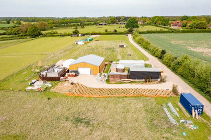 Added on 29/01/2026Farmland