West Woodlands, Frome, Somerset, BA11
- Land size
- 27.05 acres
Key Features
- Small holding, equestrian property or residential development opportunity
- 27.05 acres
- Private Treaty
Description
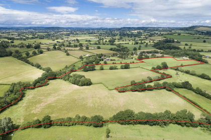
Land, buildings and yard space in a sought after location just south of the town of Frome. The property presents an excellent opportunity to create a small holding, equestrian property or residential development subject to the necessary consents. In total the property extends to approximately 27.05 acres (10.95 Ha) or thereabouts.
The property comprises two agricultural buildings, both benefitting from Full planning consent for conversion from agricultural to residential use, should prospective purchasers wish to do so. Alternatively, the buildings present an opportunity for continued agricultural use or potential to convert to commercial or equestrian subject to the necessary consents.
To the east of the buildings and yard area is a productive block of permanent pasture land with the property in total extending to approximately 27.05 acres (10.95 Ha).
BUILDINGS
Building A: Block construction with rendered exterior, the core part of the building has a CA roof with a lean-to of similar construction under CI roof. The building has three distinct rooms; The core part of the building (59’1” x 18’4”) has sliding door to front together with pedestrian doorway. The open fronted garage (12’7” x 18’2”) with timber cladding on part. The end Garage (9’6” x 18’2”) has timber doors to front with construction as detailed above.
Building B: Steel portal framed construction (59’7” x 30’6”) with concrete floor throughout, block dividing wall and external wall on western side. Steel profile cladding to the rear and one side, under fibre cement sheeted roof. Adjoining lean-to (59’7” x 19’3”) of steel portal frame construction, concrete floor throughout, block walling under fibre cement sheeted roof, steel profile cladding.
SERVICES
Buildings: We understand historically there has been a mains water and a mains electricity supply to the buildings.
Land: We understand historically there has been mains water supply to troughs on the land.
All prospective purchasers are to make their own enquiries with the statutory utility providers and the current services to the property.
ACCESS
The property benefits from excellent access directly from the B3092 via a gateway followed by a hard-core track leading to the land and building which is within the property’s ownership.
OVERAGE CLAUSE
We understand there is an overage clause covering residential development of each of the buildings stating 7% of the Gross Development Value is payable to a previous owner within 10 days of a disposal of these buildings. Furthermore we understand there is an overage provision over the agricultural land stating should the land be used as a solar array, a payment of 30% of any uplift in value (less planning costs) will be due to a previous owner. Further details from the selling agents.
FLOOD ZONE
According to information from the Environment Agency, parts of the subject property are designated as being at risk of flooding from rivers or seas without defences, with a flood risk rating of high.
LOTTING
It is anticipated that the property will be offered as lotted, but the Vendor reserves the right to sell the property as a whole or in lots privately or to amalgamate, withdraw, sub-divide, alter, add to or amend any lot or any part prior to the sale. No responsibility can be accepted for any expenses incurred by intending purchasers inspecting properties which have been sold, let or withdrawn.
TOWN AND COUNTRY PLANNING
Prior approval has been obtained on the buildings on site which are further described as follows:
Building A: Ref. No: 2023/1775/PAA Prior Approval for a proposed change of use of agricultural building to a dwellinghouse (Class C3) and for associated operational development. This prior approval was approved on 7th November 2023 and allows the conversion to a three bedroom single storey property.
Building B: Ref. No: 2026/0602/FUL Conversion of Masonry Barn to a Single Dwelling
Further to the above applications, a full planning application has recently been submitted for the conversion of buildings A ref (2026/0602/FUL) we understand that a seperate full planning application will be submitted for building B. . Further information from the selling agents.
RIGHTS OF WAY, EASEMENTS
We understand there is a right of access in between Buildings A and B and through the agricultural land via the trackway, in favour of the solar development located to the north east. In addition we understand there is also a right of access south of Building B to the compound area. We understand this trackway is to be maintained by the owners of the property. There is a public footpath traversing the property from west to east.
The property is offered for sale subject to and with the benefit of all matters contained in or referred to in the property charges register of the registered title together with all public and private rights of way, wayleaves, easements and other rights of way whether these are specifically referred to or not.
TENURE
The land is of freehold tenure with full vacant possession available upon completion of the purchase.
HEALTH & SAFETY
All persons wishing to view the property do so entirely at their own risk. Neither the Vendors or their Agents will be held liable for any damage or injury that may occur when interested parties are visiting the property. We advise that children under the age of 14 do not attend viewings due to the hazardous nature of the building.
VIEWING
Strictly by appointment only with the agent.
The property is located within the hamlet of West Woodlands, just south of Frome, combining peaceful rural surroundings with excellent access to local amenities. There is a good selection of nearby schools, including highly regarded primary options in Frome and well established secondary provision such as Frome College.
Transport links are convenient, with easy road access to the A361 and A36 for routes toward Bath, Warminster, and the wider Somerset and Wiltshire areas. Frome railway station is only a short drive away, offering direct services to Bath, Bristol, and London, making the location ideal for commuters seeking countryside living without compromising on connectivity. Other nearby towns include Shepton Mallet approximately 14 miles west, Wincanton approximately 15 miles south west.
Map Location
Property details
- Tenure
- Ask Agent
- Council Tax Band
- TBC
- Date Posted
- 2026-04-02
Market Value Analysis
Compared with 74 Farmland & Pasture listings in South West England (25+ acres).
Utilities & Restrictions
Utilities
- Electricity
- Ask Agent
- Water
- Ask Agent
- Heating
- Ask Agent
- Broadband
- Ask Agent
- Sewerage
- Ask Agent
Rights & Restrictions
- Public Rights of Way
- Ask Agent
- Private Rights of Way
- Ask Agent
- Listed Property
- Ask Agent
- Restrictions
- Ask Agent
Listed status, conservation areas and planning constraints for this location are in the full report.
Property Features
- Accessibility
- Ask Agent
- Parking
- Parking Available
- Garden
- Garden
Beyond the particulars: planning activity, flood history, heritage and ground risks, checked for this exact spot.
Connectivity
Broadband
Fastest speed available at this postcode
5 Mbps
Under 10 Mbps here
Suitable for
- Basic browsing & email
Fixed wireless access may also be an option here.
Mobile signal
Outdoor predictions; indoor signal depends on building materials.
Ofcom Connected Nations postcode-level predictions. Speeds and signal are modelled, not measured, and vary between addresses and providers.
Signal is the easy part. Planning activity, flood history and protected designations here are in the full report.
Nearest Schools
Primary
- Christ Church First School1.8 milesOfsted report card · Jan 2026
- Ages
- 2 to 9
- Pupils
- 47
- Type
- Academy sponsor led
- Faith
- Church of England
- St John's Church of England Voluntary Aided First School, Frome2.4 milesOfsted: Requires improvement
- Ages
- 4 to 9
- Pupils
- 185
- Type
- Voluntary aided school
- Faith
- Church of England
- Avanti Park School2.4 milesOfsted: Good
- Ages
- 4 to 13
- Pupils
- 503
- Type
- Free schools
- Trinity Church of England First School2.5 milesNo Ofsted rating
- Ages
- 5 to 9
- Pupils
- 297
- Type
- Academy converter
- Faith
- Church of England
- Nunney First School2.6 milesNo Ofsted rating
- Ages
- 4 to 9
- Pupils
- 76
- Type
- Academy sponsor led
Secondary
- Oakfield Academy2.6 milesOfsted: Requires improvement
- Ages
- 9 to 13
- Pupils
- 490
- Type
- Academy converter
- Selwood Academy3 milesOfsted: Good
- Ages
- 9 to 13
- Pupils
- 658
- Type
- Academy converter
- Faith
- Church of England/Methodist
- Frome Community College3.4 milesNo Ofsted rating
- Ages
- 13 to 18
- Pupils
- 1,298
- Type
- Academy converter
- Kingdown School6.8 milesNo Ofsted rating
- Ages
- 11 to 18
- Pupils
- 1,347
- Type
- Academy converter
- Matravers School7.1 milesOfsted: Good
- Ages
- 11 to 18
- Pupils
- 958
- Type
- Foundation school
Distances are straight-line from the advertised location. Source: the national school registers (DfE, Welsh Government, Scottish Government) and Ofsted.
Schools are just the start: sold prices nearby, planning activity and any flood history are in the full report.
Amenities
Supermarket
GP surgery
Pharmacy
Hospital
Straight-line distances from the advertised location. Sources: NHS records, Geolytix supermarket locations, OS Open Greenspace and the national trails registers.
The area stacks up? Now check the location itself: planning nearby, protected designations and past flooding.
Getting Around
Nearest station
Nearest bus stop
Typical drive times
Straight-line distances from the advertised location; drive times are typical free-flow times over OpenStreetMap road data, so allow more at peak. Public transport locations from DfT NaPTAN.
Easy to reach matters. So do planning activity, flood history and ground risks: all in the full report.
Flood Risk
From Environment Agency flood map open data, checked around the advertised map pin and allowing for the listed acreage where known. This summary comes from LandSale, the advertising platform, not from the listing agent, and is not part of the agent's particulars. Risk can vary across a single holding, so verify anything critical through your own searches before committing.
Rivers and the sea
Mapped within the area searched, not at the advertised map pin itself.
Surface water
Mapped within the area searched, not at the advertised map pin itself.
The detail behind these bandings
The full report pinpoints where this location sits on the flood maps, and runs the deeper checks that usually only surface after an offer.
- Exact flood zones & annual chances (included in the full report)
- Any recorded past flooding (included in the full report)
- Planning activity nearby (included in the full report)
- Heritage & conservation (included in the full report)
- Protected nature designations (included in the full report)
- Ground risks (included in the full report)
- Sold prices nearby (included in the full report)
£14.99 · one-off purchase
By LandSale, the platform. Not provided by the listing agent. Ready in about a minute.
Important notice: Information, maps and tags on this page are drawn from the advertising agent's marketing materials or generated automatically. LandSale has not verified them. Relying on these details is at your own risk, always carry out independent checks before committing to a purchase.
LandSale full disclaimer
Marketing information only - not formal particulars. The details on this website are provided for general guidance and do not constitute an offer or contract. Neither LandSale nor the advertising estate/land agent accepts responsibility for any inaccuracy.
1. Source of information
- Listing content: Core description, asking price, tenure, measurements, photographs and planning history originate from the marketing materials of the advertising estate or land agent. LandSale does not author this content and cannot guarantee its accuracy.
- Automated tags & categorisation: Property type, land-use class, acreage bands and similar labels may be applied by machine-learning models. They are intended as a helpful guide only and may not reflect the property's legal status or permitted use.
- Third-party & enriched data layers: Maps, boundary outlines, planning designations, soil reports, broadband coverage and other environmental or location-based insights are licensed from external suppliers. Such data are supplied “as is", may be incomplete or out of date and are subject to change without notice.
2. Verification required
Prospective purchasers must verify critical matters, including but not limited to planning permission, title boundaries, public rights of way, environmental constraints, acreage, services, access and VAT status, through their own inspections, specialist surveys, legal advisers and the selling agent before relying on the information or entering into any contract.
3. No warranty or liability
LandSale gives no warranty, express or implied, as to the accuracy, completeness or fitness for any particular purpose of the information displayed. LandSale shall not be liable for any loss, damage, cost or expense arising directly or indirectly from any use of or reliance on such information, save where liability may not be excluded by law.
4. Updates & feedback
If you believe any detail on this listing is inaccurate, please let us know. We will investigate and, where appropriate, update the listing or notify the agent.
© LandSale | Version 1.3 - August 2026
Similar properties for sale
- Price
- Guide Price£390,000
- Size
- 33.34 acres
West Street, Fontmell Magna, Shaftesbury, Dorset, SP7, Fontmell Magna, Dorset SP7 England
Added on 08/08/2026Agricultural Land
- Price
- £400,000
- Size
- 33.17 acres
Land at Burrington Road, Charterhouse, Priddy, Somerset BS40 England
Added on 05/08/2026Pasture
- Price
- Offers in Excess of£390,000
- Size
- 30.2 acres
Keynsham, Bristol, BS30, Hanham Abbots, South Gloucestershire BS30 England
Added on 10/03/2026Pasture
- Price
- Guide Price£500,000
- Size
- 44.74 acres
Land at Northalls Farm, Isle Abbotts, Somerset, TA3, Isle Abbotts, Somerset TA3 England
Added on 19/08/2026Arable Land
- Price
- Guide Price£575,000
- Size
- 56.85 acres
Added on 26/08/2026Agricultural Land
- Price
- Offers in Excess of£480,000
- Size
- 48.77 acres
Added on 10/08/2026Agricultural Land
- Price
- Guide Price£485,000
- Size
- 42.57 acres
Whitestaunton, Chard, Somerset, Whitestaunton, Somerset TA20 England
Added on 22/06/2026Grazing Land