Strategic Land Opportunity – Land at Maesgwynne, Fishguard, Pembrokeshire, SA65 9BQ
- Land size
- 28.14 acres
Key Features
- Site area: c. 11.39 ha (28.14 acres)
- Total indicative capacity: 342 dwellings (175 within the plan period + 167 beyond)
- Minimum yield (plan period): 175 dwellings
- Affordable housing (indicative): 10%
- Delivery timescale: Medium / Long term (Years 6–16)
- Additional units beyond plan period: 167 dwellings
- The site is available for promotion and acquisition via an option / subject to planning structure and parties are invited to submit terms
- We invite proposals from interested parties, to be submitted by midday on Friday 24 April 2026
Description
Strategic Land Opportunity – Inviting Option / Subject to Planning Proposals
Powells are instructed to invite proposals from developers to take forward the continued promotion of the site through the Pembrokeshire Replacement Local Development Plan (LDP2 / RLDP) examination process, secure the allocation through adoption, and thereafter obtain a planning consent for residential development, with completion on purchase within a timescale to be agreed.
RLDP Allocation
The site is allocated in the Deposit Plan under Policy GN 19A – Maesgwynne, Fishguard (S/HSG/034F/LDP2/1)
• Site area: c. 11.39 ha (28.14 acres)
• Total indicative capacity: 342 dwellings (175 within the plan period + 167 beyond)
• Minimum yield (plan period): 175 dwellings
• Affordable housing (indicative): 10%
• Delivery timescale: Medium / Long term (Years 6–16)
• Additional units beyond plan period: 167 dwellings
Policy GN 19A – Key Requirements
The Deposit Plan confirms that part of the wider Maesgwynne site (“Parc Loktudi”) has already been developed and the remainder should be progressed via a co-ordinated masterplanned approach.
A masterplan is required for the remainder of the site, to incorporate (amongst other matters):
• Public and amenity open space;
• SuDS;
• A buffer zone adjacent to the Maesgwynne Farm complex (including listed building setting considerations);
• Areas protected for nature conservation (including Maesgwyn Lane and related hedgerows/trees);
• Sustainable access and movement.
Vehicular access must meet the requirements of the Trunk Road Authority.
Site Information
Land at Maesgwynne, Fishguard comprises a strategic residential land opportunity identified within the Pembrokeshire County Council LDP2 (Deposit 2). The site extends to approximately 11.39 hectares (28.14 acres).
The site requires a comprehensive approach to bring forward residential development, consistent with the masterplanning requirements set out in Policy GN 19A. The area hatched in blue on the Site Plan is expressly intended to safeguard the setting of the existing farmhouse and will be retained free from built development, with use limited to non–built form only.
Key Information
Services: Interested parties must make and rely upon their own enquiries regarding the availability, capacity, routeing, and cost of connections to all mains services and utilities, together with any necessary off-site works.
Wayleaves, Easements & Rights of Way: The land is to be offered subject to, and with the benefit of, all existing wayleaves, easements, covenants, and all public and private rights of way, whether or not referred to in these particulars. Interested parties attention is drawn to the fact there is gas pipeline infratructure crossing parts of the site and a private drainage easement between the owner and Wales and West Housing Association.
VAT: The VAT status of the land is to be confirmed. Interested parties must satisfy themselves as to any VAT implications.
Viewing Arrangements: The land may be viewed from the public highway. On site viewings are strictly by prior appointment through the agent only.
Planning Context
The RLDP is currently progressing through the examination process. The appointed Inspectors have raised a number of evidence-base matters which the Council must address to enable the Plan to proceed.
In broad terms, the Inspectors have sought:
• A clearer and more robust position on Habitats Regulations Assessment (HRA) and the mitigation approach to European site constraints, including in-combination effects;
• Strengthened evidence on infrastructure delivery (costs, funding sources, delivery bodies and timescales);
• Clarification and justification on the Plan’s alignment with updated flood policy / TAN 15 and the role of SFCA evidence;
• Improved transparency and robustness on deliverability, phasing and implementation for allocations.
These points are relevant to the site and should be addressed within a developer’s promotion and planning strategy, particularly in respect of ecology/HRA, drainage, highways, and deliverability.
The Deposit Plan records that a consent for 50 homes (100% affordable) has been granted on land adjacent to Clos-y-Bigney / land north of Maesgwyn.
Interested parties should set out a clear strategy for:
• Engagement with the RLDP team / examination process;
• Masterplanning (including safeguarding/buffers to the existing farm complex);
• Technical workstreams (highways, drainage/SuDS, ecology/HRA, heritage setting, landscape/visual);
• Programme to planning submission, determination and completion.
Invitation of Proposals
The site is available for promotion and acquisition via an option / subject to planning structure and parties are invited to submit terms as follows:
• Type of agreement (option / conditional)
• Purchase price / valuation mechanism, including assumptions, abnormal costs and any caps/deductibles
• Premium payment(s) (if applicable)
• Term(s) of agreement / longstop
• Detailed Planning strategy, including approach to RLDP examination engagement and securing allocation through adoption
• Masterplanning approach, including safeguarding/buffers to the Maesgwynne Farm complex and delivery of open space and SuDS
• Highways strategy, including engagement with the Trunk Road Authority in respect of A40
• Confirmation of payment of landowner’s professional fees (agent and legal)
• Deliverability evidence, including funding / board approvals / track record on comparable strategic allocations
For further details, please contact: Stuart Leaver BSc (Hons) MSc MRICS FAAV
Expressions of Interest: To register interest and receive the information pack and sales process updates, please contact the agent using the details on this brochure.
Map Location
Property details
- Tenure
- Ask Agent
- Council Tax Band
- Ask Agent
- Date Posted
- 2026-03-17
Utilities & Restrictions
Utilities
- Electricity
- Ask Agent
- Water
- Ask Agent
- Heating
- Ask Agent
- Broadband
- Ask Agent
- Sewerage
- Ask Agent
Rights & Restrictions
- Public Rights of Way
- Ask Agent
- Private Rights of Way
- Ask Agent
- Listed Property
- Ask Agent
- Restrictions
- Ask Agent
Property Features
- Accessibility
- Ask Agent
- Parking
- Ask Agent
- Garden
- Ask Agent
Important notice: Information, maps and tags on this page are supplied by the advertising agent or generated automatically. LandSale has not verified them. Relying on these details is at your own risk, always carry out independent checks before committing to a purchase.
LandSale full disclaimer
Marketing information only - not formal particulars. The details on this website are provided for general guidance and do not constitute an offer or contract. Neither LandSale nor the advertising estate/land agent accepts responsibility for any inaccuracy.
1. Source of information
- Agent-supplied content: Core description, asking price, tenure, measurements, photographs and planning history are uploaded by the appointed agent, who remains solely responsible for their accuracy.
- Automated tags & categorisation: Property type, land-use class, acreage bands and similar labels may be applied by machine-learning models. They are intended as a helpful guide only and may not reflect the property's legal status or permitted use.
- Third-party & enriched data layers: Maps, boundary outlines, planning designations, soil reports, broadband coverage and other environmental or location-based insights are licensed from external suppliers. Such data are supplied “as is", may be incomplete or out of date and are subject to change without notice.
2. Verification required
Prospective purchasers must verify critical matters, including but not limited to planning permission, title boundaries, public rights of way, environmental constraints, acreage, services, access and VAT status, through their own inspections, specialist surveys, legal advisers and the selling agent before relying on the information or entering into any contract.
3. No warranty or liability
LandSale gives no warranty, express or implied, as to the accuracy, completeness or fitness for any particular purpose of the information displayed. LandSale shall not be liable for any loss, damage, cost or expense arising directly or indirectly from any use of or reliance on such information, save where liability may not be excluded by law.
4. Updates & feedback
If you believe any detail on this listing is inaccurate, please let us know. We will investigate and, where appropriate, update the listing or notify the agent.
© LandSale | Version 1.2 - January 2026
Listing agent
Powells, Monmouth
Singleton Court Business Park, Wonastow Road, Monmouth, NP25 5JA
Contact Powells, Monmouth
Singleton Court Business Park, Wonastow Road, Monmouth, NP25 5JA
View agent profileSimilar properties for sale

- Price
- £900,000
- Size
- 45 acres
Maesgwynne Road, Fishguard, Pembrokeshire, SA65, Scleddau, Pembrokeshire SA65 9PR Wales
Added on 29/01/2026Smallholding
- Price
- Offers Over£850,000
- Size
- 15.4 acres
Letterston, Haverfordwest, Pembrokeshire, SA62, Letterston, Pembrokeshire SA62 5EG Wales
Added on 29/01/2026Country Estate
- Price
- £695,000
- Size
- 17 acres
Pantycrwyn, Letterston, Haverfordwest, Pembs SA62 5TU, Wolfscastle, Pembrokeshire SA62 5TU Wales
Added on 29/01/2026Smallholding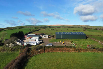
- Price
- Offers in Region of£525,000
- Size
- 18 acres
Puncheston, Haverfordwest, SA62, Puncheston, Pembrokeshire SA62 5RR Wales
Added on 11/07/2026Equestrian property
- Price
- Offers in Region of£625,000
- Size
- 17.6 acres
Wolfscastle, Haverfordwest, Wolfscastle, Pembrokeshire SA62 5NJ Wales
Added on 09/07/2026House with Land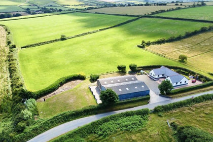
- Price
- £895,000
- Size
- 37.55 acres
Wolfscastle, Haverfordwest, SA62, Wolfscastle, Pembrokeshire SA62 5PA Wales
Added on 29/01/2026Farm
- Price
- £2,000,000
- Size
- 180 acres
Added on 10/02/2026Dairy Farm
- Price
- Guide Price£2,500,000
- Size
- 217.65 acres
Added on 29/01/2026Farm
- Price
- £635,000
- Size
- 16.07 acres
Added on 11/07/2026House with Land
- Price
- Offers in Region of£3,000,000
- Size
- 24.31 acres
Asheston House Farm, Pen Y Cwm, Haverfordwest SA62 6NH, Brawdy, Pembrokeshire SA62 6NH Wales
Added on 18/03/2026Farmhouse