Puncheston, Haverfordwest, SA62
- Land size
- 18 acres
- Bedrooms
- 2
- Bathrooms
- 1
Key Features
- PUNCHESTON
- 2 bedroomed cottage
- Equestrian Smallholding
- 18 acres
- Large Purpose Built Barn
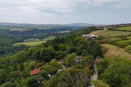
- Far Reaching Views
- 2 Bed
- EPC -TBC
- Rare find!
Description
***** Exceptional 18-Acre Equestrian Smallholding with Spectacular Far-Reaching Views Across Pembrokeshire to Milford Haven ***** *** Peacefully positioned with no near neighbours, just one mile from the village of Puncheston *** Impressive 25m x 35m equestrian/agricultural barn offering excellent potential for a variety of uses (STP) *** Charming two-bedroom cottage with scope to extend (STP) *** Recently upgraded with an air source heat pump, new hot water cylinder and an accessible wet room *** Excellent range of outbuildings including purpose-built stables *** Potential for a farm shop or similar enterprise (STP) *** Approximately 18 acres of gently sloping pasture, divided into paddocks and surrounding the property *** Nestled within the beautiful Preseli Hills, enjoying stunning views towards Mynydd Morvil *** A truly outstanding rural location, just 8 miles from Fishguard and 12 miles from Haverfordwest. Viewing is highly recommended.
Directions : From Fishguard take the B4331 Road south east in the direction of Maenclochog for some 2 1⁄2 miles passing through the hamlet of Llanychaer and continue on this road in the direction of Maenclochog for a further 31⁄2 miles or so and take the second turning on the right signposted to Puncheston. Continue on this road for a mile and a half or so and take the third turning on the right towards Llygad-yr-Haul. Proceed up the hill for 300 yards or so and upon reaching Llygad-yr-Haul, follow the road to the right and bear right towards Penlan Oleu. A For Sale Board is erected at the roadside entrance.
Alternatively from Haverfordwest, take the Main A40 Road north for some 10 miles and in the village of Letterston take the turning on the right at the crossroads, signposted to Puncheston and Little Newcastle. Continue on this road for in excess of 3 miles and proceed through the village of Puncheston and continue on this road towards Rosebush for three quarters of a mile or so and take the turning on the left for Llygad-yr-Haul. Follow directions as above. A For Sale Board is erected at the roadside entrance.
What3words : mammoth.different.cups
Mobile Signal
4G great data and voice
Construction Type
Stone Built
Location
Puncheston village is a mile with Primary school, public house and places of worship. Letterston 4 and a half miles with shops, school, public house and places of worship etc.
The towns of Fishguard and Haverfordwest are 8 and 12 miles respectively offering shops, eateries and an excellent array of facilities with Fishguard Harbour having a sailing to Rosslare, Ireland. 9 Miles approx to the popular North Pembrokeshire coastline and South Ceredigion coastline.
Cottage
A traditional stone built cottage, single storey with pitched slate roof. Adjoining outbuilding which could be extended into subject to planning.
Reception Hallway
Ceramic tiled floor, coat hooks and doors to
Kitchen/ Dining Room
3.96m x 3.81m (13' 0" x 12' 6") Max.
(maximum). With a ceramic tiled floor, Inglenook fireplace housing an Oil fired Rayburn Cooking Range, strip light, range of floor and wall cupboards, single drainer inset Stainless Steel sink unit with hot and cold, Airing Cupboard with a pre lagged copper hot water cylinder and immersion heater, uPVC double glazed window with vertical blinds, Hygena built in 4 ring L.P Gas Cooker Hob, 2 uPVC double glazed windows, radiator, 3 ceiling spotlight, part tiled surround, 7 power points and door to Inner Hall.
Living Room
3.81m x 3.05m (12' 6" x 10' 0")
Wood style flooring, Brick open fireplace with a slate hearth, TV point, telephone point, double glazed window, radiator, wall insulation to fireplace wall.
Inner Hallway
Ceramic tiled floor and doors to
Bedroom 1
3.12m x 2.74m (10' 3" x 9' 0") Max
With laminated wood floor, radiator, pull switch, ceiling light, radiator, telephone point, TV point, 4 power points and a uPVC double glazed window with roller blind.
Bedroom 2
2.74m x 2.44m (9' 0" x 8' 0") Max.
With laminated wood floor, uPVC double glazed window with roller blind, radiator, pull switch and 4 power points.
Bathroom/ Wet Room
With ceramic tiled floor, uPVC double glazed window, white suite off , disabled friendly no step shower cubicle, Wash Hand Basin and WC, part tiled surround, towel rail/shelf, toilet roll holder and a Manrose extractor fan.
Externally 1
Directly to the fore of the Property is a concrete hardstanding which allows for ample vehicle parking and turning space. Adjoining the Cottage on the southern gable end is a:-
Store Shed
5.49m x 3.66m (18' 0" x 12' 0") Approx.
Timber and corrugated asbestos constructions. Ideal to demolish and build extension subject to planning and building regulations.
Purpose Built Kennel
6.55m x 2.88m (21' 6" x 9' 5")
With concreted base, insulated timber clad walls and a pitched composition slate roof. It has 4 uPVC double glazed windows, a uPVC double glazed entrance door, 8 downlighters and 4 power points.
Hayshed
With an adjoining 2 Bay Lean-to.
Store/Hay/Machinery Shed
Former Cowshed
Of stone construction with a corrugated asbestos roof.
Former Dairy
3.48m x 2.64m (11' 5" x 8' 8")
Of concrete block construction with a corrugated asbestos roof with strip light and 4 power points.
Former Silage Pit / Store
13.72m x 6.1m (45' 0" x 20' 0")
With strip lights and power points.
N.B. Half the Store Shed which measures 22'6" x 20'0" (6.86m x 6.10m) has a suspended floor and is timber clad with potential as Workshop or even as a Dry Store.
Stables
9.14m x 6.1m (30' 0" x 20' 0")
Loose Box
5.6m x 4.5m (18' 4" x 14' 9")
Of concrete block and timber construction with box profile cladding and roof.
Multi Purpose Shed
10.7m x 5.7m (35' 1" x 18' 8")
With strip lights and power points. Currently used as 3 Stables.
Lean to Loose Housing Shed
10.67m x 5.94m (35' 0" x 19' 6")
Of concrete block and timber construction with box profile cladding and roof with electric light and power points.
Cubicle Shed For 14.
6.55m x 5.79m (21' 6" x 19' 0")
Of concrete block and corrugated iron construction with a concreted base.
Stables / Foaling Shed
10.97m x 6.10m (36' 0" x 20' 0")
Approx. There are 2 Stables measuring 12' x 10' (3.66m x 3.05m) and a Foaling Box 20'6" x 14'6" (6.25m x 4.42m)
Stable Block
Of timber construction with a concreted floor. There are 3 Stables each measuring 12'6" x 11'6" (3.81m x 3.51m) and a:-
Tack Room
5.33m x 3.66m (17' 6" x 12' 0") Approx.
Large Multi Purpose Agricultural / Equestrian Building
33.53m x 24.38m (110' 0" x 80' 0")
( which is 18'0" (5.5m) to the eaves) Utilised for Machinery / Fertilizer Storage or the like (Subject to any necessary Consents).
Adjacent to the Multipurpose Agricultural/Equestrian Building is a large hardsurfaced Vehicle parking area which extends to a Third of an Acre or thereabouts.
Externally 2
3 Outside Water Taps and 4 Outside Electric Lights.
The land in total extends to some 18 acres or thereabouts which is all down to permanent pasture and is in the main, gently sloping with a southerly aspect. The perimeter boundary of the land is in the main sheep fenced.
The boundaries of the property are coloured red on the attached plan to the Scale of 1/2500.
Services
Mains Water (metered supply) and Electricity are connected. Cesspit/Effluent Tank Drainage. UPVC Double Glazing. Loft Insulation. Telephone, subject to British Telecom Regulations. Oil Fired Rayburn Cooking Range.
N.B. In March 2023, the Property has been upgraded to an Eco Friendly Air to Water Heating System which includes a new generation 6 Samsung Heat Pump and a Kodak Smart Pre Plumb Cylinder Boiler.
There is also a Wireless Digital 7 day programmable Room Thermostat and Receiver. New radiators have been installed in both Bedrooms, Living Room and Kitchen. The Living Room fireplace wall has been insulated and re-plastered. The Loft is fully insulated and the Rayburn Range is now utilised for cooking only.
12 Photovoltaic Solar Panels have been fitted alongside the Equestrian Building which stand at ground level. The Equestrian Building has its own mains fuse board and control panels for the Solar Panels and also has an internet adapter, twin p...
Council tax
The property is listed under the Local Authority of Pembrokeshire County Council. Council Tax Band for the property - 'D'.
Access
Vehicle and Pedestrian Access Rights of Way exist in favor of Penlan Oleu over the hard surfaced track which leads up to the Property. The track is owned by the next door property, Llygad-yr-Haul.
Tenure and Possession
Freehold with Vacant Possession upon Completion
Anti Money Laundering
By law, we are required to conduct anti-money laundering checks on all potential buyers and sellers, and we take this responsibility very seriously. In line with HMRC guidelines and legal regulations, our trusted independent and industry recognised partner, Coadjute (Coadjute | Overview), will securely manage these checks on our behalf. Once an offer is accepted (subject to contract), Coadjute will send a secure link for you to complete the biometric checks electronically. These are legal requirements which we cannot ignore. A non-refundable fee of £45 + VAT per person will apply for these checks, and Coadjute will handle the payment for this service. You as a buyer will pay Coadjute directly. These anti-money laundering checks must be completed before we can send the memorandum of sale to the solicitors to confirm the sale. Please contact the office if you have any questions in relation to this. Please note: the property will remain on the market until the checks have been complete...
Map Location
Property details
- Tenure
- Freehold
- Council Tax Band
- D
- Date Posted
- 2026-07-11
Price history
| Date | Change | Price |
|---|---|---|
| 17 Aug 2026 | Reduced 5% (−£25,000) | £475,000 |
| Until 17 Aug 2026 | Asking price | £500,000 |
Market Value Analysis
Compared with 13 Equestrian listings in Wales (10+ acres).
Energy Performance Certificate
Energy Efficiency Rating
Based on UK Energy Performance Certificate standards (EU Directive 2002/91/EC)
Running costs are one side. Planning activity, flood history and ground risks for this location are in the full report.
Utilities & Restrictions
Utilities
- Electricity
- Mains
- Water
- Mains
- Heating
- Air Source Heat Pump
- Broadband
- Standard Copper (ADSL)
- Sewerage
- Mains
Rights & Restrictions
- Public Rights of Way
- Ask Agent
- Private Rights of Way
- Ask Agent
- Listed Property
- Ask Agent
- Restrictions
- Ask Agent
Listed status, conservation areas and planning constraints for this location are in the full report.
Property Features
- Accessibility
- Ask Agent
- Parking
- Disabled Parking
- Garden
- Garden
Beyond the particulars: planning activity, flood history, heritage and ground risks, checked for this exact spot.
Connectivity
Broadband
Fastest speed available at this postcode
16 Mbps
Standard (10-30 Mbps)
Suitable for
- Web & social
- Music streaming
- Standard video calls
Mobile signal
Predicted 4G and 5G signal; indoor signal depends on building materials.
Ofcom Connected Nations postcode-level predictions. Speeds and signal are modelled, not measured, and vary between addresses and providers.
Signal is the easy part. Planning activity, flood history and protected designations here are in the full report.
Nearest Schools
Primary
- Puncheston Community Primary School1 mile
- Pupils
- 76
- Type
- Infants & Juniors
- Language
- Welsh medium school / provision (including transitional)
- Ysgol Llanychllwydog2.1 miles
- Pupils
- 29
- Type
- Nursery, Infants & Juniors
- Language
- Welsh medium school / provision (including transitional)
- Wolfscastle Communty Primary School4.6 miles
- Pupils
- 50
- Type
- Nursery, Infants & Juniors
- Language
- Welsh medium school / provision (including transitional)
- Ysgol Gymunedol Maenclochog4.6 miles
- Pupils
- 98
- Type
- Infants & Juniors
- Language
- Welsh medium school / provision (including transitional)
- Ysgol Ger y Llan4.9 miles
- Pupils
- 101
- Type
- Nursery, Infants & Juniors
- Language
- Welsh medium school / provision (including transitional)
Secondary
- Ysgol Bro Gwaun5.7 miles
- Pupils
- 574
- Type
- Secondary (ages 11-16)
- Language
- Dual language school / provision (Welsh and English) (including transitional)
- Ysgol Caer Elen9.1 miles
- Pupils
- 907
- Type
- Middle (ages 3-16)
- Language
- Welsh medium school / provision (including transitional)
- Ysgol Bro Preseli10 miles
- Pupils
- 932
- Type
- Middle (ages 3-19)
- Language
- Welsh medium school / provision (including transitional)
- Haverfordwest High VC School11 miles
- Pupils
- 1,699
- Type
- Secondary (ages 11-19)
- Language
- English medium school / provision
- Ysgol Uwchradd Aberteifi14 miles
- Pupils
- 614
- Type
- Secondary (ages 11-19)
- Language
- Welsh medium school / provision (including transitional)
Distances are straight-line from the advertised location. Source: the national school registers (DfE, Welsh Government, Scottish Government) and Ofsted.
Schools are just the start: sold prices nearby, planning activity and any flood history are in the full report.
Amenities
Supermarket
GP surgery
Pharmacy
Straight-line distances from the advertised location. Sources: NHS records, Geolytix supermarket locations, OS Open Greenspace and the national trails registers.
The area stacks up? Now check the location itself: planning nearby, protected designations and past flooding.
Getting Around
Nearest station
Nearest bus stop
Typical drive times
Straight-line distances from the advertised location; drive times are typical free-flow times over OpenStreetMap road data, so allow more at peak. Public transport locations from DfT NaPTAN.
Easy to reach matters. So do planning activity, flood history and ground risks: all in the full report.
Flood Risk
Natural Resources Wales open data, checked around the advertised map pin for the listed acreage. Long-term risk counts flood defences; the planning map's flood zones do not. Provided by LandSale, not the listing agent, and not part of the agent's particulars. Risk varies across a holding, so verify before committing.
Rivers and the sea
Planning map: Flood Zone 1.
Surface water
Not at the pin: mapped about 140 metres away.
These bandings are the summary. Where this location sits on the flood maps, plus planning activity, heritage and ground risks, is in the full report.
Important notice: Information, maps and tags on this page are drawn from the advertising agent's marketing materials or generated automatically. LandSale has not verified them. Relying on these details is at your own risk, always carry out independent checks before committing to a purchase.
LandSale full disclaimer
Marketing information only - not formal particulars. The details on this website are provided for general guidance and do not constitute an offer or contract. Neither LandSale nor the advertising estate/land agent accepts responsibility for any inaccuracy.
1. Source of information
- Listing content: Core description, asking price, tenure, measurements, photographs and planning history originate from the marketing materials of the advertising estate or land agent. LandSale does not author this content and cannot guarantee its accuracy.
- Automated tags & categorisation: Property type, land-use class, acreage bands and similar labels may be applied by machine-learning models. They are intended as a helpful guide only and may not reflect the property's legal status or permitted use.
- Third-party & enriched data layers: Maps, boundary outlines, planning designations, soil reports, broadband coverage and other environmental or location-based insights are licensed from external suppliers. Such data are supplied “as is", may be incomplete or out of date and are subject to change without notice.
2. Verification required
Prospective purchasers must verify critical matters, including but not limited to planning permission, title boundaries, public rights of way, environmental constraints, acreage, services, access and VAT status, through their own inspections, specialist surveys, legal advisers and the selling agent before relying on the information or entering into any contract.
3. No warranty or liability
LandSale gives no warranty, express or implied, as to the accuracy, completeness or fitness for any particular purpose of the information displayed. LandSale shall not be liable for any loss, damage, cost or expense arising directly or indirectly from any use of or reliance on such information, save where liability may not be excluded by law.
4. Updates & feedback
If you believe any detail on this listing is inaccurate, please let us know. We will investigate and, where appropriate, update the listing or notify the agent.
© LandSale | Version 1.3 - August 2026
Similar properties for sale
- Price
- Guide Price£400,000
- Size
- 9 acres
Added on 29/09/2026House with Land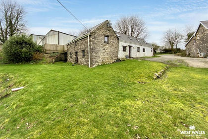
- Price
- Offers in Excess of£575,000
- Size
- 22.68 acres
Llanycefn, Clynderwen, Maenclochog, Pembrokeshire SA66 Wales
Added on 05/03/2026Barn Conversion
- Price
- £450,000
- Size
- 17 acres
Penybryn, Cardigan, SA43, Cilgerran, Pembrokeshire SA43 Wales
Added on 05/10/2026Smallholding
- Price
- Guide Price£425,000
- Size
- 13 acres
Llanboidy CARMARTHENSHIRE, Llanboidy, Carmarthenshire SA34 Wales
Added on 08/10/2026Smallholding
- Price
- Fixed Price£499,950
- Size
- 10 acres
Llangwm, Haverfordwest, SA62, Freystrop, Pembrokeshire SA62 Wales
Added on 23/07/2026House with Land
- Price
- £469,000
- Size
- 9 acres
Added on 29/01/2026Smallholding- Price
- Offers in Region of£379,000
- Size
- 9 acres
Added on 02/10/2026House with Land
- Price
- £575,000
- Size
- 13 acres
Blaenwaun, Whitland, SA34, Llanwinio, Carmarthenshire SA34 Wales
Added on 11/04/2026Smallholding
- Price
- Offers in Region of£550,000
- Size
- 9 acres
Great Plains Road, Stepaside, SA67, Amroth, Pembrokeshire SA67 Wales
Added on 03/07/2026Equestrian property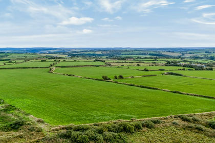
- Price
- Guide Price£475,000
- Size
- 69 acres
Added on 24/09/2026Smallholding