Square & Compass, Haverfordwest, SA62
- Land size
- 180 acres
Key Features
- Highly desirable and equipped dairy farm extending to 180 acres (72.85 hectares)
- Excellent range of modern farm buildings with 250 matted cubicles
- De Laval 18/36 fully automated herringbone milking parlour
- Suitable for growing excellent crops of grass and arable crops
- Tracked system with fenced enclosures and strategically placed water troughs
- Slurry lagoon and silage clamps meeting NVZ requirements
- Edge of renowned Pembrokeshire Coast National Park
Description
A highly desirable and well-equipped 180 acre dairy farm situated in a renowned early growing area in north - west Pembrokeshire.
Overview
Llwyndyrys Farm is a highly desirable and well-equipped commercial dairy farm extending to approx. 180 acres (72.85 hectare) in total, positioned in predominantly south-facing position in north – west Pembrokeshire, a short distance in-land from the renowned Pembrokeshire Coast National Park.
The farm is set-up as a one-man dairy unit, benefitting from an excellent range of modern farm buildings, to include extensive cubicle and loose housing accommodation, a modern dairy and parlour, covered feeding areas, feedstores, silage clamp and slurry lagoon, meeting all current NVZ regulations.
The land is level to gently sloping in nature, being split into two principal blocks, with circa 147 acres ringfenced around the farmstead being laid to productive pasture and an arable rotation, serviced by a tracked system, fenced enclosures and strategically placed water troughs, to exploit a long grazing and growing season. The second block is an off-lying parcel of 33 acres, utilised for cutting purposes.
Situation
The property lies in near 8-mile equal distance between the city of St Davids and the harbour town of Fishguard, fronting the A487 highway, in the small village of Square and Compass, being home to a public house, petrol station and convenience store. The county town of Haverfordwest lies 15 miles to the south, being the commercial centre of the county, with an excellent and comprehensive range of amenities and services.
The renowned Pembrokeshire coastline is a short distance away, with the highly sought-after fishing and harbour villages of Porthgain, Aberiddi and Trefin, are all within a short driving distance away, being home to well-regarded eateries and beaches.
The farm lies within easy reach of several livestock markets to include Whitland, Crymych, Carmarthen and Newcastle Emlyn. There are number of established milk factories in nearby Haverfordwest to include First Milk, Totally Welsh and Pembrokeshire Creamery, whilst Newcastle Emlyn is home to Dairy Partners.
General Purpose Building
14.37m x 15.66m (47' 2" x 51' 5") (3-bay)
Of steel stanchions with part concrete panelled and brick walls with box profile and Yorkshire boarding sheeted elevations, under box profile sheeted roof. Water troughs. 2500 litre fuel tank.
Loose Housing
9.25m x 14.36m (30' 4" x 47' 1") (3-bay)
Of steel stanchion with part concrete block walls construction, with box profile and Yorkshire boarding elevations under box profile sheeted roof. Water troughs.
50,000 Gallon Reception Pit
With slurry pump to main lagoon.
Dairy Buildings
Of concrete block construction under a pitched box profile sheeted roof, comprising:
Dairy: 4.74m x 6.49m (15' 7" x 21' 4") Housing the Dairy Master 16,000 litre bulk tank.
Pump Room: 5.34m x 4.73m (17' 6" x 15' 6") 10,000 litre water tank.
Wash Room: 2.31m x 5.00m (7' 7" x 16' 5") automated parlour washer system.
Office: 3.02m x 1.79m (9' 11" x 5' 10") Landline and broadband connection.
Milking Parlour and Handling Building with Colleting Yard
Steel and timber frame with concrete block and panelled walls construction, with Yorkshire boarding elevations under a pitched fibre cement roof.
Milking Parlour: 22.36m x 7.15m (73' 4" x 23' 5")
De Laval Herringbone 18/36 fully automated swing over milking parlour with milk meters feed to yield.
Handling Facility: 22.36m x 4.68m (73' 4" x 15' 4")
With a cattle handling race, crush and drafting gate.
Collecting Yard: 90' 0" x 30' 0" (27.43m x 9.14m)
Automatic scrapers and backing gate. Concrete Floor.
Modern Livestock Housing & Feeding Passage
Concrete reinforced and steel portal framed construction with concrete panelled walls and Yorkshire boarding elevations under fibre cement sheeted roofs.
250 matted cubicles and loose housing accommodation.
Cubicle Housing: 90' 0" x 30' 0" (27.43m x 9.14m) + 90' 0" x 65' 0" (27.43m x 19.81m) + 90' 0" x 35' 0" (27.43m x 10.67m).
Loose Housing: 95' 0" x 40' 0" (28.96m x 12.19m)
Feeding Passage: 35' 0" x 170' 0" (10.67m x 51.82m)
Cow Kennels
48' 0" x 45' 0" (14.63m x 13.72m)
Timber framed under pitched zinc sheeted roof with 48 kennels.
Silage Clamp
170'0" x 100'0" (51.82m x 30.48m)
Concrete floor constructed to NVZ specification in 2020.
Slurry Lagoon
1,750,00 gallon slurry lagoon with attenuation pond.
Static Caravan & timber framed porch
Benefitting from mains electricity and water connection with drainage to cesspool/effluent tank.
Storage Building in Field near Mathry
35' 0" x 21' 0" (10.67m x 6.40m)
Of concrete block construction under a corrugated iron sheeted roof.
Land
The land extends to 180 acres (72.84 hectares) in total being gently sloping in nature, and split in to two main blocks.
The principal block extends to approx. 147 acres (59.49 hectares) and is ringfenced around the farmstead being laid to productive pasture and in an arable rotation, being serviced by a track system, fenced enclosures and strategically placed water troughs. The second block is an off-lying parcel of 32.37 acres (approx.), situated 1 mile east, suitable for cutting and silage purposes, with the benefit of three gated access points the A487 highway.
The land is classified as freely draining acid loamy soils over rock and Grade 3b according to the Agricultural Land Classification Map produced by the Welsh Government.
Schedule of Area
Tenure
We understand that the property is held on a Freehold basis.
Services
Mains water (metered) connected to both blocks of land. The dairy unit has its own private supply from a bore hole. Mains electricity (three phase). Broadband connection. CCTV installed.
Wayleaves, Easements and Rights of Way
The property is sold subject to and with the benefit of all rights, including rights of way, whether public or private, light, support, drainage, water, and electricity supplies and any other rights and obligations, easements and proposed wayleaves for masts, pylons, stays, cables, drains and water, gas and other pipes, whether referenced or not.
IACS
We understand the property is registered.
Agricultural Holding Number
55/450/0172
Basic Payment Scheme
The Basic Payment Scheme entitlements are included in the sale.
Method of Sale
Llwyndyrys Farm is offered For Sale via private treaty as a whole.
Plans, Areas and Schedules
A copy of the plan is attached for identification purposes only. The purchasers shall be deemed to have satisfied themselves as to the description of the property. Any error or mis-statement shall not annul a sale or entitle any party to compensation in respect thereof.
Planning
All planning related enquiries to Pembrokeshire County Council Planning Department.
3G County Hall, Haverfordwest, Pembrokeshire, SA61 1TP.
Telephone: 01437 764551.
Local Authority
Pembrokeshire County Council, County Hall, Haverfordwest, Pembrokeshire, SA61 1TP.
Telephone: 01437 764 551.
Pembrokeshire Coast National Park
National Park Office, Llanion Park, Pembroke Dock, Pembrokeshire, SA72 6DY.
Telephone: 01267 234545
What 3 Word / Postcode
///tastier.shout.pillow / SA62 5JJ
Viewing
Strictly by appointment with sole selling agents Rees Richards & Partners.
Please contact Carmarthen office for further information - 12 Spilman Street, Carmarthen SA31 1LQ.
Tel: 01267 612021
Email: [email protected]
Map Location
Property details
- Tenure
- Freehold
- Council Tax Band
- Ask Agent
- Date Posted
- 2026-02-10
Market Value Analysis
Compared with 6 Dairy Farms listings in Wales (100+ acres).
Property Brochure
Seen the details? The full report adds the independent checks: planning activity, flood history, heritage and ground.
Utilities & Restrictions
Utilities
- Electricity
- Ask Agent
- Water
- Ask Agent
- Heating
- Ask Agent
- Broadband
- Ask Agent
- Sewerage
- Ask Agent
Rights & Restrictions
- Public Rights of Way
- Ask Agent
- Private Rights of Way
- Ask Agent
- Listed Property
- Ask Agent
- Restrictions
- Ask Agent
Listed status, conservation areas and planning constraints for this location are in the full report.
Property Features
- Accessibility
- Ask Agent
- Parking
- Ask Agent
- Garden
- Garden
Beyond the particulars: planning activity, flood history, heritage and ground risks, checked for this exact spot.
Connectivity
Broadband
Fastest speed available at this postcode
1.8 Gbps
Gigabit full fibre · available to 44% of premises
Suitable for
- 4K streaming on every screen
- Full-time home working
- Online gaming & big downloads
Mobile signal
Predicted 4G and 5G signal; indoor signal depends on building materials.
Ofcom Connected Nations postcode-level predictions. Speeds and signal are modelled, not measured, and vary between addresses and providers.
Signal is the easy part. Planning activity, flood history and protected designations here are in the full report.
Nearest Schools
Primary
- Ysgol Gymunedol Croesgoch1.8 miles
- Pupils
- 108
- Type
- Nursery, Infants & Juniors
- Language
- Welsh medium school / provision (including transitional)
- Ysgol Penrhyn Dewi5.4 miles
- Pupils
- 606
- Type
- Middle (ages 3-16)
- Language
- English medium school / provision
- Ysgol Ger y Llan5.4 miles
- Pupils
- 101
- Type
- Nursery, Infants & Juniors
- Language
- Welsh medium school / provision (including transitional)
- Roch Community School6.1 miles
- Pupils
- 126
- Type
- Nursery, Infants & Juniors
- Language
- English medium school / provision
- Ysgol Gymunedol Wdig / Goodwick Community School6.9 miles
- Pupils
- 110
- Type
- Nursery, Infants & Juniors
- Language
- Welsh medium school / provision (including transitional)
Secondary
- Ysgol Penrhyn Dewi5.4 miles
- Pupils
- 606
- Type
- Middle (ages 3-16)
- Language
- English medium school / provision
- Ysgol Bro Gwaun7 miles
- Pupils
- 574
- Type
- Secondary (ages 11-16)
- Language
- Dual language school / provision (Welsh and English) (including transitional)
- Ysgol Caer Elen11 miles
- Pupils
- 907
- Type
- Middle (ages 3-16)
- Language
- Welsh medium school / provision (including transitional)
- Haverfordwest High VC School11 miles
- Pupils
- 1,699
- Type
- Secondary (ages 11-19)
- Language
- English medium school / provision
- Milford Haven School15 miles
- Pupils
- 1,045
- Type
- Secondary (ages 11-16)
- Language
- English medium school / provision
Distances are straight-line from the advertised location. Source: the national school registers (DfE, Welsh Government, Scottish Government) and Ofsted.
Schools are just the start: sold prices nearby, planning activity and any flood history are in the full report.
Amenities
Supermarket
GP surgery
Pharmacy
Walking trail
Straight-line distances from the advertised location. Sources: NHS records, Geolytix supermarket locations, OS Open Greenspace and the national trails registers.
The area stacks up? Now check the location itself: planning nearby, protected designations and past flooding.
Getting Around
Nearest station
Nearest bus stop
Typical drive times
Straight-line distances from the advertised location; drive times are typical free-flow times over OpenStreetMap road data, so allow more at peak. Public transport locations from DfT NaPTAN.
Easy to reach matters. So do planning activity, flood history and ground risks: all in the full report.
Flood Risk
Natural Resources Wales open data, checked around the advertised map pin for the listed acreage. Long-term risk counts flood defences; the planning map's flood zones do not. Provided by LandSale, not the listing agent, and not part of the agent's particulars. Risk varies across a holding, so verify before committing.
Rivers and the sea
Planning map: Flood Zone 1.
Surface water
Not at the pin: mapped about 20 metres away.
These bandings are the summary. Where this location sits on the flood maps, plus planning activity, heritage and ground risks, is in the full report.
Important notice: Information, maps and tags on this page are drawn from the advertising agent's marketing materials or generated automatically. LandSale has not verified them. Relying on these details is at your own risk, always carry out independent checks before committing to a purchase.
LandSale full disclaimer
Marketing information only - not formal particulars. The details on this website are provided for general guidance and do not constitute an offer or contract. Neither LandSale nor the advertising estate/land agent accepts responsibility for any inaccuracy.
1. Source of information
- Listing content: Core description, asking price, tenure, measurements, photographs and planning history originate from the marketing materials of the advertising estate or land agent. LandSale does not author this content and cannot guarantee its accuracy.
- Automated tags & categorisation: Property type, land-use class, acreage bands and similar labels may be applied by machine-learning models. They are intended as a helpful guide only and may not reflect the property's legal status or permitted use.
- Third-party & enriched data layers: Maps, boundary outlines, planning designations, soil reports, broadband coverage and other environmental or location-based insights are licensed from external suppliers. Such data are supplied “as is", may be incomplete or out of date and are subject to change without notice.
2. Verification required
Prospective purchasers must verify critical matters, including but not limited to planning permission, title boundaries, public rights of way, environmental constraints, acreage, services, access and VAT status, through their own inspections, specialist surveys, legal advisers and the selling agent before relying on the information or entering into any contract.
3. No warranty or liability
LandSale gives no warranty, express or implied, as to the accuracy, completeness or fitness for any particular purpose of the information displayed. LandSale shall not be liable for any loss, damage, cost or expense arising directly or indirectly from any use of or reliance on such information, save where liability may not be excluded by law.
4. Updates & feedback
If you believe any detail on this listing is inaccurate, please let us know. We will investigate and, where appropriate, update the listing or notify the agent.
© LandSale | Version 1.3 - August 2026

Listing agent
Rees Richards and Partners, Swansea
12 Spilman Street, Carmarthen, SA31 1LQ
Contact Rees Richards and Partners, Swansea
12 Spilman Street, Carmarthen, SA31 1LQ
View agent profileNearby properties for sale
- Price
- £850,000
- Size
- 9 acres
Mathry, Haverfordwest, SA62, Mathry, Pembrokeshire SA62 Wales
Added on 29/01/2026Smallholding
- Price
- Offers in Region of£1,500,000
- Size
- 9.22 acres
Haverfordwest, SA62, Haverfordwest, Pembrokeshire SA62 Wales
Added on 07/07/2026Country Estate
- Price
- Guide Price£495,000
- Size
- 24.32 acres
Dwrbach, Fishguard, SA65, Fishguard, Pembrokeshire SA65 Wales
Added on 12/10/2026Smallholding
- Price
- £695,000
- Size
- 17 acres
Pantycrwyn, Letterston, Haverfordwest, Pembs SA62, Wolfscastle, Pembrokeshire SA62 Wales
Added on 29/01/2026Smallholding
- Price
- Guide Price£300,000
- Size
- 9.35 acres
Rhysgwyllt Farmhouse, Letterston SA62, Letterston, Pembrokeshire SA62 Wales
Added on 08/10/2026Smallholding
- Price
- £895,000
- Size
- 37.55 acres
Wolfscastle, Haverfordwest, SA62, Wolfscastle, Pembrokeshire SA62 Wales
Added on 29/01/2026Farm
- Price
- Guide Price£495,000
- Size
- 9 acres
Added on 12/10/2026Smallholding
- Price
- £585,000
- Size
- 5 acres
Camrose, Haverfordwest, SA62, Haverfordwest, Pembrokeshire SA62 Wales
Added on 13/07/2026Smallholding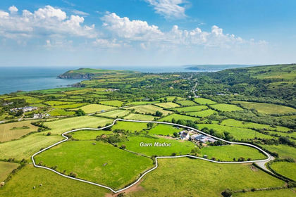
- Price
- Guide Price£1,350,000
- Size
- 11 acres
Added on 01/06/2026Farmhouse
- Price
- £1,250,000
- Size
- 10.8 acres
Added on 29/05/2026House with Land