Plot 1, Main Road, Donington-on-bain
- Land size
- 0.2 acres
Key Features
- Full planning permission granted
- 2 bedroom Dorma house design
- Popular Wolds Village with shops and pub
- New Price to help buyer with costs towards Archeological dig requirements
- Impressive design in keeping with village
- Plot of 0.2 Acres (sts)
- Positioned opposite the Church
- Adjacent plot
- South facing garden
Description
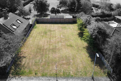
NEW PRICE!!! A unique development opportunity in a popular Lincolnshire Wolds village to acquire a building plot benefitting from full Planning Permission for the erection of a detached 2 bed home. Positioned in a superb, elevated spot opposite the church on a generous plot of around 0.2 acres (sts). New Price to help buyer with costs towards Archeological dig requirements
Directions Proceed away from Louth along Westgate and to the roundabout on the bypass, then carry straight on and at the South Elkington fork, bear left. Follow the A631 to Welton-le-Wold and after passing the garage on the left, take the next left turn along the Bluestone Heath Road. At the first crossroads turn right towards Donington-on-Bain, follow the lane and eventually at the T-junction, turn left towards the village. The plot will be found on the right just on the right turning off the main road into the entrance for Donington-on-Bain primary school and the gated access to the plot is immediately on your left.
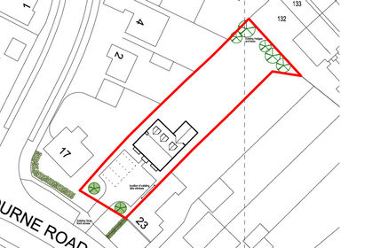
Description This plot now has the benefit of full planning permission for a detached 2 bedroom dwelling as indicated on the attached plans. A generous plot extending towards the rear, currently laid to lawn and having a slight gradient back towards the road giving it an elevated position. The plot measures approximately 0.2 acres (subject to survey). Fenced boundaries to sides with hedged boundary to the front. Range of mature bushes and trees and currently having concrete path, collapsed brick building to front, further brick-built outhouse to right hand side in dilapidated condition and aluminium-framed greenhouse which are the buyer's responsibility to remove.
Planning details for the plot (Ref; N/042/01395/23) can be reviewed online which was granted on 18th September 2023. The relevant plans can be found on the East Lindsey Council's website: https://www.e-lindsey.gov.uk/applications and are available from the selling agent on request by e-mail. The proposed layout is shown on the indicated plans and applicants should carefully consider the planning decision notice in full, the approved plans, conditions and requirements. An Archaeological Evaluation Report and Heritage Impact Statement has been completed and is available to download from the planning portal.
The Proposed House A well designed Dorma style house is shown in the attached plans with well planned accommodation and light, airy living space with large windows. A traditional pitched main roof covered in tiles with a rough render wall finish. The property will be well positioned in the plot having driveway with ample space all round with the rear enjoying a southerly aspect and extending into the deep long garden.
Internally the accommodation opens into the large kitchen living dining room with patio doors to the garden with the spacious lounge adjacent. A rear hallway beyond gives access to the shower room and utility with turned staircase leading to first floor. Off the first floor landing with storage cupboards are two double bedrooms one with dormer rear window. Finally, a spacious bathroom completes the accommodation.
Services The purchaser is to satisfy themselves as to the exact position and accessibility of nearby mains services and will be required to make their own connections. It is believed mains water, electricity and drainage are located nearby.
Access and maintenance The site is accessed from the public highway.
Wayleaves, Easements, Covenants, Conditions and Rights of Way
The plot is sold subject to and with benefit of all existing wayleaves, easements and rights of way, whether mentioned in these particulars or not.
Viewings Viewing during daylight hours by prior appointment is permitted unaccompanied. Please contact our office for further details.
VAT It is not anticipated that VAT will be charged, however should any sale of any part of the land or any rights attached to it become chargeable supply for the purpose of VAT, such tax will be payable by the buyer(s) in addition to the contract price.
Tenure The site is offered for sale freehold with vacant possession upon completion.
Situation Donington-on Bain is around 8 miles from Louth market town and around 10 miles equidistant from Market Rasen and Horncastle, the former having rail links to the national network and the latter known for its many antique and bric-a-brac shops. Louth is known as the Capital of the Wolds and has three markets each week and an attractive Conservation Area around the superb St James Church. There are many restaurants, bars, wine bars and cafes in addition to the independent shops and numerous sports and hobby activities.
The cathedral city of Lincoln is approximately 20 miles away while the holiday coast is about 21 miles, with resorts, nature reserves and miles of open beach. One of the best villages in the Wolds for amenities having post office with shop, convenience store, the Black Horse pub serving food and providing visitor accommodation, a mobile library service, excellent mobile fish and chip van, a multi-use games area with playing fields and hard tennis courts and a children's play area.
The Viking Way passes through the centre of the village leading through the countryside for miles either to the north or south (149 miles in total for the hardy!) The village hall hosts several events including craft fairs, race nights, Pilates, yoga and card nights. There is a village primary school and bus service to the secondary/grammar schools and academies in the area. The stone-built Grade 2 Listed Church of St Andrew stands opposite the property in the heart of the village and is c.1779, restored 1868 with origins dating back to the late 12th Century.
General Information The particulars are intended to give a fair and substantially correct overall description for the guidance of intending purchasers. Plans/maps and highlighted images are not to specific scale, are based on information supplied and subject to verification by a solicitor at sales stage against the sale contract plans. Site dimensions have been measured to apparent boundaries on site and should be verified against the contract plans when these have been completed. BDLD
Text…
Text...
Map Location
Property details
- Tenure
- Freehold
- Council Tax Band
- TBC
- Date Posted
- 2026-03-12
Property Brochure
Seen the details? The full report adds the independent checks: planning activity, flood history, heritage and ground.
Utilities & Restrictions
Utilities
- Electricity
- Ask Agent
- Water
- Ask Agent
- Heating
- Ask Agent
- Broadband
- Ask Agent
- Sewerage
- Ask Agent
Rights & Restrictions
- Public Rights of Way
- Ask Agent
- Private Rights of Way
- Ask Agent
- Listed Property
- Ask Agent
- Restrictions
- Ask Agent
Listed status, conservation areas and planning constraints for this location are in the full report.
Property Features
- Accessibility
- Ask Agent
- Parking
- Off-Street Parking
- Garden
- Garden
Beyond the particulars: planning activity, flood history, heritage and ground risks, checked for this exact spot.
Connectivity
Broadband
Fastest speed available at this postcode
1.8 Gbps
Gigabit full fibre · available to 57% of premises
Suitable for
- 4K streaming on every screen
- Full-time home working
- Online gaming & big downloads
Fixed wireless access may also be an option here.
Mobile signal
Predicted 4G and 5G signal; indoor signal depends on building materials.
Ofcom Connected Nations postcode-level predictions. Speeds and signal are modelled, not measured, and vary between addresses and providers.
Signal is the easy part. Planning activity, flood history and protected designations here are in the full report.
Nearest Schools
Primary
- The Donington-on-Bain School153 metresOfsted: Good
- Ages
- 4 to 11
- Pupils
- 103
- Type
- Community school
- Scamblesby Church of England Primary School3.6 milesOfsted: Good
- Ages
- 4 to 11
- Pupils
- 46
- Type
- Voluntary controlled school
- Faith
- Church of England
- Kidgate Academy6.4 milesOfsted: Requires improvement *
- Ages
- 4 to 11
- Pupils
- 397
- Type
- Academy converter
- Legsby Primary School6.5 milesOfsted: Good
- Ages
- 4 to 11
- Pupils
- 26
- Type
- Community school
- St Michael's Church of England School, Louth6.6 milesNo Ofsted rating
- Ages
- 4 to 11
- Pupils
- 291
- Type
- Voluntary controlled school
- Faith
- Church of England
Secondary
- King Edward VI Grammar School6.1 milesOfsted: Good
- Ages
- 11 to 18
- Pupils
- 900
- Type
- Academy converter
- Louth Academy6.7 milesOfsted: Good
- Ages
- 11 to 16
- Pupils
- 891
- Type
- Academy sponsor led
- Queen Elizabeth's Grammar School, Horncastle8.3 milesOfsted: Good
- Ages
- 11 to 18
- Pupils
- 788
- Type
- Academy converter
- De Aston School8.4 milesNo Ofsted rating
- Ages
- 11 to 18
- Pupils
- 939
- Type
- Academy converter
- Faith
- Christian
- The Banovallum School8.8 milesNo Ofsted rating
- Ages
- 11 to 16
- Pupils
- 621
- Type
- Academy converter
* Latest graded judgement covers quality of education only; no overall grade was issued under the 2024-25 inspection framework.
Distances are straight-line from the advertised location. Source: the national school registers (DfE, Welsh Government, Scottish Government) and Ofsted.
Schools are just the start: sold prices nearby, planning activity and any flood history are in the full report.
Amenities
Supermarket
GP surgery
Pharmacy
Hospital
Green space
Straight-line distances from the advertised location. Sources: NHS records, Geolytix supermarket locations, OS Open Greenspace and the national trails registers.
The area stacks up? Now check the location itself: planning nearby, protected designations and past flooding.
Getting Around
Nearest station
Nearest bus stop
Typical drive times
Straight-line distances from the advertised location; drive times are typical free-flow times over OpenStreetMap road data, so allow more at peak. Public transport locations from DfT NaPTAN.
Easy to reach matters. So do planning activity, flood history and ground risks: all in the full report.
Flood Risk
Environment Agency open data, checked around the advertised map pin for the listed acreage. Long-term risk counts flood defences; the planning map's flood zones do not. Provided by LandSale, not the listing agent, and not part of the agent's particulars. Risk varies across a holding, so verify before committing.
Rivers and the sea
Planning map: Flood Zone 1.
Surface water
Not at the pin: mapped about 10 metres away.
These bandings are the summary. Where this location sits on the flood maps, plus planning activity, heritage and ground risks, is in the full report.
Important notice: Information, maps and tags on this page are drawn from the advertising agent's marketing materials or generated automatically. LandSale has not verified them. Relying on these details is at your own risk, always carry out independent checks before committing to a purchase.
LandSale full disclaimer
Marketing information only - not formal particulars. The details on this website are provided for general guidance and do not constitute an offer or contract. Neither LandSale nor the advertising estate/land agent accepts responsibility for any inaccuracy.
1. Source of information
- Listing content: Core description, asking price, tenure, measurements, photographs and planning history originate from the marketing materials of the advertising estate or land agent. LandSale does not author this content and cannot guarantee its accuracy.
- Automated tags & categorisation: Property type, land-use class, acreage bands and similar labels may be applied by machine-learning models. They are intended as a helpful guide only and may not reflect the property's legal status or permitted use.
- Third-party & enriched data layers: Maps, boundary outlines, planning designations, soil reports, broadband coverage and other environmental or location-based insights are licensed from external suppliers. Such data are supplied “as is", may be incomplete or out of date and are subject to change without notice.
2. Verification required
Prospective purchasers must verify critical matters, including but not limited to planning permission, title boundaries, public rights of way, environmental constraints, acreage, services, access and VAT status, through their own inspections, specialist surveys, legal advisers and the selling agent before relying on the information or entering into any contract.
3. No warranty or liability
LandSale gives no warranty, express or implied, as to the accuracy, completeness or fitness for any particular purpose of the information displayed. LandSale shall not be liable for any loss, damage, cost or expense arising directly or indirectly from any use of or reliance on such information, save where liability may not be excluded by law.
4. Updates & feedback
If you believe any detail on this listing is inaccurate, please let us know. We will investigate and, where appropriate, update the listing or notify the agent.
© LandSale | Version 1.3 - August 2026

Listing agent
Masons Sales, Louth
Cornmarket, Louth, LN11 9QD
Similar properties for sale
- Price
- £120,000
- Size
- 0.23 acres
Legbourne Road, Louth LN11, Louth, Lincolnshire LN11 England
Added on 03/06/2026Building Plot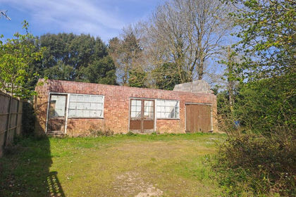
- Price
- Offers in Region of£80,000
Building Plot, East Road, Tetford, Tetford, Lincolnshire LN9 England
Added on 05/08/2026Building Plot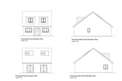 Added on 24/02/2026Building Plot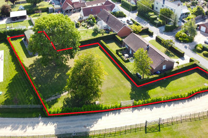
- Price
- £125,000
- Size
- 0.25 acres
Building Plot at Trianja, Church Lane, Alvingham LN11, Louth, Lincolnshire LN11 England
Added on 29/01/2026Building Plot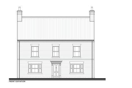
- Price
- £85,000
- Size
- 0.25 acres
Plot 2 Carlton Road, Manby, Manby, Lincolnshire LN11 England
Added on 29/01/2026Building Plot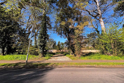
- Price
- £85,000
- Size
- 0.25 acres
Plot 1 Carlton Road, Manby, Louth, Manby, Lincolnshire LN11 England
Added on 29/01/2026Building Plot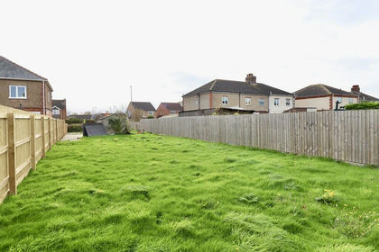 Added on 29/01/2026Building Plot
 Added on 02/08/2026Building Plot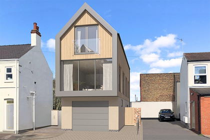
- Price
- Offers Over£110,000
Segmere Street, Cleethorpes, Great Grimsby and Cleethorpes, North East Lincolnshire DN35 England
Added on 10/04/2026Building Plot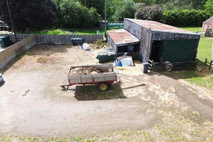 Added on 12/06/2026Building Plot