Ware, Hertfordshire
- Land size
- 15.54 acres
Key Features
- A wonderful collection of period buildings and later properties
- Total gross floor area of approx. 7,784 sq m (83,776 sq ft)
- Splendid Grade II and Grade II* Listed
- Principal buildings with captivating architecture and interior features
- Private, tranquil rural setting with mature wooded surroundings
- Extensive gardens, sports fields, woodland, car parks and long drive approach
- Investment, development and change of use opportunities (subject to contract and planning)
- About 6.29 hectares (15.54 acres)
- Extensive accommodation to include conference rooms, teaching spaces, library, theatre, kitchens, dining areas and offices plus extensive residential accommodation for pupils and staff
Description
An historic college campus with alternative use potential (subject to contract and planning).
Property Summary
All Nations Christian College is situated on a site of approximately 15 acres surrounded by the Easneye Estate in an attractive rural part of Hertfordshire. The site consists of a mixture of listed Victorian buildings in the Gothic Revival style and more recent buildings built primarily in the 1970s and 80s.
The site, with its original Victorian buildings, was purchased by the College in 1970 from the Buxton family, who still own and farm the surrounding Easneye Estate. The original buildings were designed by Sir Alfred Waterhouse, a prolific 19th Century architect of some note. Easneye House is reputed to be his first residential commission. Given its providence and architectural importance, Easneye House carries a Grade II* listing, whilst other important period buildings on site such as the former Stables and converted Coach House carry a Grade II Listing.
The Victorian mansion at the centre of the site provides an elegant focal point to the campus and features wonderful architecture with tall gables, impressive chimney stacks, ornate brickwork and stained-glass windows. Inside are grand former reception rooms and the magnificent reception hall with a dramatic oak staircase. Of particular note on the upper floors is the large atrium with galleried landings and crowned by a stained-glass lantern.
The former stables and coach house have been converted to offices and residential accommodation whilst numerous other buildings are in a variety of uses and offer flexibility of future use. In addition to the main college buildings there are a range of useful outbuildings plus ‘Oak Tree Cottages’ and ‘The Cedars’ offering outlying residential accommodation.
Situation
Nestled in the heart of the Hertfordshire countryside, All Nations Christian College has for decades, been a peaceful and inspiring setting for learning, reflection, and community. Located on the beautiful Easneye Estate, just outside the historic market town of Ware, the college is surrounded by rolling parkland and mature woodlands.
Despite its tranquil rural setting, the property enjoys excellent transport connections. It is 2.6 miles to the A10, which leads north to Cambridge (33 miles distant) and south into London. Central London is about 35 miles away and it is just under 10 miles to Junction 25 of the M25 Motorway. Stansted Airport is about 19 miles away. It is less than 2 miles to St. Margarets railway station where direct trains to London Waterloo take from 31 minutes.
Fixtures and fittings
All fixtures and fittings, garden statuary, machinery etc. whether mentioned or not in these particulars are excluded from the sale but some may be available by separate negotiation.
Data room
Interested parties may gain detailed information in relation to the property on request. Please contact the selling agent for access details.
Services
We understand that mains water, gas and electricity are connected.
None of the services or appliances, heating installations, plumbing or electrical systems have been tested by the selling agents.
Tenure and possession
All Nations Christian College is for sale Freehold with vacant possession on completion.
Method of sale
The property is offered for sale by Private Treaty.
Local Authority
East Herts District Council.
Public rights of way, wayleaves and easements
The property is sold subject to and with the benefit of all rights of way, easements and wayleaves that may exist over the same whether disclosed or not. We understand there are no public rights of way that cross the property.
Planning
Information regarding planning and current use/designations is available in the data room.
Solicitors
Anthony Collins, 134 Edmund Street, Birmingham B3 2ES.
Legal costs
Each party to be responsible for their own legal costs incurred in this transaction.
VAT
Unless otherwise stated, all prices and quoted are exclusively of Value Added Tax (VAT). Any intending purchaser should satisfy themselves independently as to VAT in respect of this transaction.
Anti Money Laundering Regulations (AML)
In accordance with Anti Money Laundering Regulations (AML), we are required to request forms of identification and carry out due diligence on any parties connected to a successful offer. Should an offer be made on behalf of a business/company, AML due diligence will also be necessary. Proof/source of funding must be supplied, prior to offer acceptance.
Plans and boundaries
The plans within these particulars are based on Ordnance Survey data and provided for reference only. They are believed to be correct but accuracy is not guaranteed. The purchaser shall be deemed to have full knowledge of all boundaries and the extent of ownership. Neither the vendor nor the vendor’s agents will be responsible for defining the boundaries or the ownership thereof.
Viewings
Strictly by appointment through Fisher German LLP as sole selling agents: Bedford Office and London Office
Directions
Postcode – SG12 8LX
what3words – ///port.books.rise
Map Location
Property details
- Tenure
- Freehold
- Council Tax Band
- TBC
- Date Posted
- 2026-02-17
Market Value Analysis
Compared with 69 Homes with Land listings in East Anglia (10+ acres).
Energy Performance Certificate
Energy Efficiency Rating
Based on UK Energy Performance Certificate standards (EU Directive 2002/91/EC)
Running costs are one side. Planning activity, flood history and ground risks for this location are in the full report.
Utilities & Restrictions
Utilities
- Electricity
- Ask Agent
- Water
- Ask Agent
- Heating
- Ask Agent
- Broadband
- Ask Agent
- Sewerage
- Ask Agent
Rights & Restrictions
- Public Rights of Way
- Ask Agent
- Private Rights of Way
- Ask Agent
- Listed Property
- Ask Agent
- Restrictions
- Ask Agent
Listed status, conservation areas and planning constraints for this location are in the full report.
Property Features
- Accessibility
- Ask Agent
- Parking
- Parking Available
- Garden
- Garden
Beyond the particulars: planning activity, flood history, heritage and ground risks, checked for this exact spot.
Connectivity
Broadband
Fastest speed available at this postcode
1.8 Gbps
Gigabit full fibre
Suitable for
- 4K streaming on every screen
- Full-time home working
- Online gaming & big downloads
Mobile signal
Predicted 4G and 5G signal; indoor signal depends on building materials.
Ofcom Connected Nations postcode-level predictions. Speeds and signal are modelled, not measured, and vary between addresses and providers.
Signal is the easy part. Planning activity, flood history and protected designations here are in the full report.
Nearest Schools
Primary
- St John the Baptist Voluntary Aided Church of England Primary School0.9 milesOfsted: Good *
- Ages
- 4 to 11
- Pupils
- 155
- Type
- Voluntary aided school
- Faith
- Church of England
- St Andrew's Church of England Voluntary Controlled Primary School1 mileNo Ofsted rating
- Ages
- 3 to 11
- Pupils
- 193
- Type
- Voluntary controlled school
- Faith
- Church of England
- Priors Wood Primary School1.2 milesOfsted report card · Jan 2026
- Ages
- 3 to 11
- Pupils
- 231
- Type
- Community school
- Christ Church CofE (VA) Primary School and Nursery1.4 milesNo Ofsted rating
- Ages
- 3 to 11
- Pupils
- 332
- Type
- Voluntary aided school
- Faith
- Church of England
- Larkspur Academy1.5 milesOfsted: Good
- Ages
- 3 to 11
- Pupils
- 64
- Type
- Academy sponsor led
Secondary
- Presdales School1.4 milesOfsted: Outstanding
- Ages
- 11 to 18
- Pupils
- 1,167
- Type
- Academy converter
- Gender
- Girls
- The John Warner School1.9 milesOfsted: Inadequate
- Ages
- 11 to 18
- Pupils
- 726
- Type
- Academy converter
- The Chauncy School2.2 milesNo Ofsted rating
- Ages
- 11 to 18
- Pupils
- 1,515
- Type
- Academy converter
- Simon Balle All-Through School3.1 milesNo Ofsted rating
- Ages
- 4 to 18
- Pupils
- 1,617
- Type
- Academy converter
- Robert Barclay Academy3.4 milesOfsted: Good
- Ages
- 11 to 18
- Pupils
- 821
- Type
- Academy sponsor led
* Latest graded judgement covers quality of education only; no overall grade was issued under the 2024-25 inspection framework.
Distances are straight-line from the advertised location. Source: the national school registers (DfE, Welsh Government, Scottish Government) and Ofsted.
Schools are just the start: sold prices nearby, planning activity and any flood history are in the full report.
Amenities
Supermarket
GP surgery
Pharmacy
Hospital
Straight-line distances from the advertised location. Sources: NHS records, Geolytix supermarket locations, OS Open Greenspace and the national trails registers.
The area stacks up? Now check the location itself: planning nearby, protected designations and past flooding.
Getting Around
Nearest station
Nearest bus stop
Typical drive times
Straight-line distances from the advertised location; drive times are typical free-flow times over OpenStreetMap road data, so allow more at peak. Public transport locations from DfT NaPTAN.
Easy to reach matters. So do planning activity, flood history and ground risks: all in the full report.
Flood Risk
Environment Agency open data, checked around the advertised map pin for the listed acreage. Long-term risk counts flood defences; the planning map's flood zones do not. Provided by LandSale, not the listing agent, and not part of the agent's particulars. Risk varies across a holding, so verify before committing.
Rivers and the sea
Planning map: Flood Zone 1.
Surface water
Not at the pin: mapped about 20 metres away.
These bandings are the summary. Where this location sits on the flood maps, plus planning activity, heritage and ground risks, is in the full report.
Important notice: Information, maps and tags on this page are drawn from the advertising agent's marketing materials or generated automatically. LandSale has not verified them. Relying on these details is at your own risk, always carry out independent checks before committing to a purchase.
LandSale full disclaimer
Marketing information only - not formal particulars. The details on this website are provided for general guidance and do not constitute an offer or contract. Neither LandSale nor the advertising estate/land agent accepts responsibility for any inaccuracy.
1. Source of information
- Listing content: Core description, asking price, tenure, measurements, photographs and planning history originate from the marketing materials of the advertising estate or land agent. LandSale does not author this content and cannot guarantee its accuracy.
- Automated tags & categorisation: Property type, land-use class, acreage bands and similar labels may be applied by machine-learning models. They are intended as a helpful guide only and may not reflect the property's legal status or permitted use.
- Third-party & enriched data layers: Maps, boundary outlines, planning designations, soil reports, broadband coverage and other environmental or location-based insights are licensed from external suppliers. Such data are supplied “as is", may be incomplete or out of date and are subject to change without notice.
2. Verification required
Prospective purchasers must verify critical matters, including but not limited to planning permission, title boundaries, public rights of way, environmental constraints, acreage, services, access and VAT status, through their own inspections, specialist surveys, legal advisers and the selling agent before relying on the information or entering into any contract.
3. No warranty or liability
LandSale gives no warranty, express or implied, as to the accuracy, completeness or fitness for any particular purpose of the information displayed. LandSale shall not be liable for any loss, damage, cost or expense arising directly or indirectly from any use of or reliance on such information, save where liability may not be excluded by law.
4. Updates & feedback
If you believe any detail on this listing is inaccurate, please let us know. We will investigate and, where appropriate, update the listing or notify the agent.
© LandSale | Version 1.3 - August 2026
Similar properties for sale
- Price
- £4,250,000
- Size
- 42 acres
Added on 28/07/2026House with Land
- Price
- Guide Price£4,500,000
- Size
- 9 acres
Ashendene Road, Bayford, SG13, Bayford, Hertfordshire SG13 England
Added on 02/09/2026Country Estate
- Price
- Guide Price£5,000,000
- Size
- 15.1 acres
Munden Road, Dane End, Ware, Hertfordshire, SG12, Little Munden, Hertfordshire SG12 England
Added on 03/07/2026House with Land
- Price
- Guide Price£5,950,000
- Size
- 15 acres
Epping Upland, Epping, CM16, Epping Upland, Essex CM16 England
Added on 12/04/2026Estate
- Price
- £4,475,000
- Size
- 16.6 acres
Beggar Hill, Fryerning, CM4, Ingatestone and Fryerning, Essex CM4 England
Added on 13/02/2026Country Estate
- Price
- Offers in Region of£4,300,000
- Size
- 402.62 acres
Whitehouse Farm, Little Sampford, CB10, Little Sampford, Essex CB10 England
Added on 01/09/2026Farm
- Price
- Guide Price£5,000,000
- Size
- 11 acres
Isle of Wight Lane, Kensworth, Kensworth, Central Bedfordshire LU6 England
Added on 29/01/2026House with Land
- Price
- Guide Price£4,000,000
- Size
- 13 acres
Cholesbury Road, Cholesbury, Hertfordshire, HP23, Tring, Hertfordshire HP23 England
Added on 28/05/2026Equestrian property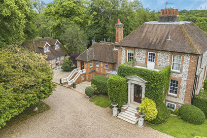
- Price
- Guide Price£4,250,000
- Size
- 17 acres
Added on 08/07/2026House with Land
- Price
- £4,500,000
- Size
- 40 acres
Gorse Hill, Farningham, Dartford, DA4, Farningham, Kent DA4 England
Added on 13/06/2026Country Home