Killingan Wood, Sedlescombe, East Sussex
- Land size
- 15.7 acres
Key Features
- Ancient and semi-natural woodland
- Located within an area of Outstanding Natural Beauty (AONB)
- In all about 15.7 acres (6.3 hectares)
Description
LOCATION
The woodland is located on the outskirts of Sedlescombe, approximately 1.2 miles from the centre of the village (The Queen's Head Public House). Westfield is approximately 3.9 miles to the south-east, Battle, approximately 4.6 miles to the south-west, and Hastings just under 8 miles to the south.
DESCRIPTION
Registered under Title Number ESX417272 (part of), the block of ancient and semi-natural woodland comprises various broadleaf species, including a rare Service Tree, Oak, Ash, Hornbeam, Silver Birch, and Holly, together with Aconites, Bluebells, and Wild Orchids in the Spring.
Within a book written by historians, Jonathan and Michael Starkey, it has been suggested that Killingan Wood was possibly a site connected to the Battle of Hastings.
ACCESS
Access is via public footpaths leading from Hurst Lane.
DIRECTIONS
From The Queen's Head Public House, head north-east along Brede Lane for approximately 0.6 miles (0.96 km), and then turn left into Hurst Lane. Continue on Hurst Lane for approximately 0.96 miles (1.5km), whereafter, the woodland will be found on the left-hand side, approximately 250m after a sharp left-handed corner.
What3Words: community.political.filter
SERVICES
There are no services connected.
TENURE
The property is offered for sale freehold with vacant possession upon completion.
LOCAL AUTHORITY
Rother District Council.
EASEMENTS, WAYLEAVES AND RIGHTS OF WAY
A public footpath runs along the western boundary, together with a second that runs adjacent to the eastern boundary. Please see the following link for further details:
The property is sold subject to and with the benefit of all existing rights whether public or private including Rights of Way, supply, drainage, water and electricity supplies or other
rights, covenants, restrictions and obligations, quasi easements, and all wayleaves, whether referred to or not within these particulars.
MINERALS, SPORTING RIGHTS AND TIMBER
All mineral rights, sporting rights and standing timber so far as they are owned are included in the Freehold.
A conveyance dated 23 September 1931 refers to a covenant regarding the sporting and mineral rights. Further information available from the selling agent.
PLANS
The attached boundary plan is for identification purposes only with boundaries shown edged red. Purchasers should satisfy themselves on the location of all external or internal boundaries prior to offering.
AGENTS NOTES
We wish to inform prospective purchasers that we have prepared these sales particulars as a general guide. None of the statements contained within these particulars relating to this property should be relied upon as a statement of fact. All measurements are given as a guide and no liability can be accepted for any errors arising therefrom.
CLIENT IDENTIFICATION
In accordance with the Money Laundering Regulations, we are now required to obtain proof of identification for all purchasers. BTF employs the services of 'Thirdfort' to verify the identity and residence of purchasers.
ACREAGES
The acreages are for guidance purposes only and are given without responsibility. Any intending purchasers should not rely upon them as statements or representations of fact but must satisfy themselves by inspection or otherwise.
VIEWING
During daylight hours only and strictly by prior appointment with the Vendor's Sole Agents, BTF Partnership.
The vendors and their agents do not accept any responsibility for accidents or personal injury as a result of viewings, whether accompanied or not.
Map Location
Property details
- Tenure
- Freehold
- Council Tax Band
- Ask Agent
- Date Posted
- 2026-02-12
Market Value Analysis
Compared with 12 Woodland listings in South East England (10+ acres).
Utilities & Restrictions
Utilities
- Electricity
- Ask Agent
- Water
- Ask Agent
- Heating
- Ask Agent
- Broadband
- Ask Agent
- Sewerage
- Ask Agent
Rights & Restrictions
- Public Rights of Way
- Ask Agent
- Private Rights of Way
- Ask Agent
- Listed Property
- Ask Agent
- Restrictions
- Ask Agent
Property Features
- Accessibility
- Ask Agent
- Parking
- Ask Agent
- Garden
- Ask Agent
Important notice: Information, maps and tags on this page are supplied by the advertising agent or generated automatically. LandSale has not verified them. Relying on these details is at your own risk, always carry out independent checks before committing to a purchase.
LandSale full disclaimer
Marketing information only - not formal particulars. The details on this website are provided for general guidance and do not constitute an offer or contract. Neither LandSale nor the advertising estate/land agent accepts responsibility for any inaccuracy.
1. Source of information
- Agent-supplied content: Core description, asking price, tenure, measurements, photographs and planning history are uploaded by the appointed agent, who remains solely responsible for their accuracy.
- Automated tags & categorisation: Property type, land-use class, acreage bands and similar labels may be applied by machine-learning models. They are intended as a helpful guide only and may not reflect the property's legal status or permitted use.
- Third-party & enriched data layers: Maps, boundary outlines, planning designations, soil reports, broadband coverage and other environmental or location-based insights are licensed from external suppliers. Such data are supplied “as is", may be incomplete or out of date and are subject to change without notice.
2. Verification required
Prospective purchasers must verify critical matters, including but not limited to planning permission, title boundaries, public rights of way, environmental constraints, acreage, services, access and VAT status, through their own inspections, specialist surveys, legal advisers and the selling agent before relying on the information or entering into any contract.
3. No warranty or liability
LandSale gives no warranty, express or implied, as to the accuracy, completeness or fitness for any particular purpose of the information displayed. LandSale shall not be liable for any loss, damage, cost or expense arising directly or indirectly from any use of or reliance on such information, save where liability may not be excluded by law.
4. Updates & feedback
If you believe any detail on this listing is inaccurate, please let us know. We will investigate and, where appropriate, update the listing or notify the agent.
© LandSale | Version 1.2 - January 2026
Listing agent
BTF Partnership, Heathfield
Euston House 82a High Street, Heathfield, TN21 8JD
Contact BTF Partnership, Heathfield
Euston House 82a High Street, Heathfield, TN21 8JD
View agent profileSimilar properties for sale

- Price
- Guide Price£130,000
- Size
- 4.75 acres
Pashley Road, Ticehurst, East Sussex, TN5, Ticehurst, East Sussex TN5 7HE England
Added on 29/01/2026Vacant Land
- Price
- Offers in Excess of£150,000
- Size
- 9.37 acres
Added on 29/01/2026Pasture
- Price
- Guide Price£95,000
- Size
- 6.25 acres
Argos Hill, Rotherfield, Rotherfield, East Sussex TN6 3QH England
Added on 04/07/2026Vacant Land
- Price
- Guide Price£150,000
- Size
- 0.7 acres
Added on 28/05/2026Grazing Land
- Price
- £150,000
- Size
- 1.7 acres
Green Lane, Crowborough, TN6, Crowborough, East Sussex TN6 2XB England
Added on 22/04/2026Grazing Land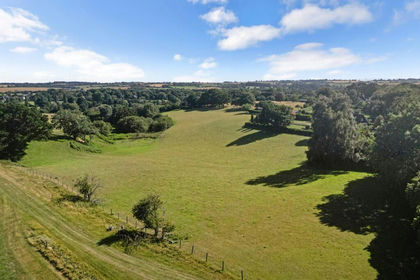
- Price
- Guide Price£125,000
- Size
- 9 acres
Southenay Lane, Sellindge, Ashford, Kent, TN25, Sellindge, Kent TN25 6AN England
Added on 09/07/2026Vacant Land
- Price
- Guide Price£140,000
- Size
- 3 acres
Plots A,B,C Hever Road, Edenbridge, Edenbridge, Kent TN8 5LD England
Added on 29/01/2026Vacant Land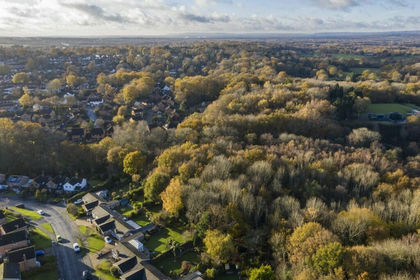
- Price
- £75,000
- Size
- 9 acres
Eden Vale, East Grinstead, West Sussex, RH19, Dormansland, Surrey RH19 2JJ England
Added on 17/07/2026Undeveloped Land
- Price
- £63,150
- Size
- 4.21 acres
Added on 18/06/2026Pasture
- Price
- Guide Price£110,000
Haven Field, Cudham, Greater London, Orpington, Bromley TN16 2HT England
Added on 28/01/2026Vacant Land