Bodidris Hall
- Land size
- 6.99 acres
- Bedrooms
- 6
- Bathrooms
- 4
Key Features
- Six bedroom and four bathroom Elizabethan manor house
- Set in approximately eight acres of parkland setting
- Extensive (11,000 sqft) stone barns with planning permission for up to eight cottages (available by separate negotiation)
- Impressive master bedroom suite with views over private lake and Llandegla forest
- Landscaped walled garden and orchard
Description
Bodidris Hall was also used as accommodation for the Earl of Leicester, who fought with Evan Lloyd in Ireland and knighted him in 1586. Leicester is said to have used Bodidris between 1563 and 1578 as his hunting lodge and his heraldic badge, the bear and the ragged staff, appears on the south gable.
During the 19th century the ownership of Bodidris passed to the Williams family of Bodelwyddan Castle. Sir Hugh Williams gave money for the new school at Llandegla and his sister paid for the rebuilding of Llandegla church.
Bodidris Hall is a substantial stone Manor House with a slate roof. Part timbered sections offer clues to the evolution of the house and fine stone mullioned windows and oak doors are a particular feature of the property. In spite of its scale Bodidris is well balanced for modern family living and has been impressively restored to a high standard by the current owner.
The heavy panelled front door beside a stone terrace adjacent to a large gravelled parking area at the side of the house opens into a hall with a stone floor, a cloakroom and wc. It leads to a reception hall linking the kitchen to the main reception rooms and containing wonderful ancient oak stairs. Beneath the stairs is a larder/wine store.
A fine oak partition provides the division from the superb family kitchen with an excellent bespoke Clive Christian kitchen with high quality appliances, including a LaCanche cooking range, marble work tops and a substantial island. At the opposite end of the room is an area for dining and beside a door to the back hall a seating area within a former inglenook. Off the back hall is a second staircase and a corridor with fitted cupboards leading to a utility room. A door opens onto the drive.
At the front of the house offering views over the grounds and valley beyond is an impressive drawing room with heavy oak beams, bespoke oak flooring, a fireplace, panelled walls and a dining room also with bespoke flooring.
On the first floor is a stunning master bedroom suite with far reaching views, built in dressing room and bathroom and two further suites. There are two staircases to the second floor with one leading to a cinema room which links to a kitchen and WC. This area may offer scope for the creation of a staff flat. The second stairs lead to a landing serving a study with fitted shelving, two further bedrooms and a family bathroom.
Outside beautiful landscaped grounds are set within a walled garden. They include hard landscaping in the form of terracing for dining and entertaining, a range of specimen plants and trees together with lawns. Beside the house is a substantial outbuilding providing garaging, a workshop and storage. There is a gravel driveway a turning area and substantial wooden gates. In front of the house are rolling lawns leading to a large lake with a small island.
Available in addition are the Grade II* listed outbuildings are situated to the south west of Bodidris Hall and comprise the Old Stable Block and three cottages requiring renovation being: - Gardeners Cottage - Grooms Cottage - Laundry Cottage
The handsome buildings are arranged around a courtyard and The Old Stable Block is a particularly fine building with an elegant cupola style clock tower.
Planning consent was granted on 25th February 2015 (Application 17/2014/0980) for Alterations to 4 dwellings and conversion of redundant outbuildings together with associated works including installation of replacement effluent treatment plant. The permission was later altered to remove an occupancy condition giving a full residential permission for 8 properties.
Summary of proposed accommodation:
8 units comprising: 3 x 4 bed, 3 x 3 bed and 2 x 2 bed, parking, gardens.
Total Floor Area approximately 10,700 sq ft
Location
Bobidris Hall is around 10 miles from the city Wrexham which offers a range of retail, educational and commercial services as well as access to the A483/A5 linking Chester and Shrewsbury.
The property is well situated for many leisure activities such as walking and riding on Offa's Dyke and Moel Famau, fishing, and Snowdonia National Park is also about an hour from the property.
The commercial centre of Chester is approximately 22 miles away, which provides a superb range of shopping and leisure facilities and some excellent schools including Kings and Queens. Chester also gives access to the motorway network providing a link to other North West and Midlands conurbations and to Liverpool and Manchester airports.
Square Footage: 8,048 sqft
Acreage: 6.99 Acres
Map Location
Property details
- Tenure
- Freehold
- Council Tax Band
- I
- Date Posted
- 2026-01-29
Market Value Analysis
Compared with 365 Homes with Land listings in Wales (5+ acres).
Utilities & Restrictions
Utilities
- Electricity
- Mains
- Water
- Private Supply
- Heating
- Ask Agent
- Broadband
- Ask Agent
- Sewerage
- Septic Tank / Private
Rights & Restrictions
- Public Rights of Way
- Ask Agent
- Private Rights of Way
- Yes
- Listed Property
- Ask Agent
- Restrictions
- Ask Agent
Listed status, conservation areas and planning constraints for this location are in the full report.
Property Features
- Accessibility
- Ask Agent
- Parking
- Parking Available
- Garden
- Garden
Beyond the particulars: planning activity, flood history, heritage and ground risks, checked for this exact spot.
Connectivity
Broadband
Fastest speed available at this postcode
1.8 Gbps
Gigabit full fibre
Suitable for
- 4K streaming on every screen
- Full-time home working
- Online gaming & big downloads
Mobile signal
Predicted 4G and 5G signal; indoor signal depends on building materials.
Ofcom Connected Nations postcode-level predictions. Speeds and signal are modelled, not measured, and vary between addresses and providers.
Signal is the easy part. Planning activity, flood history and protected designations here are in the full report.
Nearest Schools
Primary
- Ysgol Dyffryn Ial1 mile
- Pupils
- 42
- Type
- Nursery, Infants & Juniors
- Language
- Dual language school / provision (Welsh and English) (including transitional)
- Ysgol Bro Famau2 miles
- Pupils
- 61
- Type
- Nursery, Infants & Juniors
- Language
- English medium school / provision
- Ysgol Pentrecelyn3.5 miles
- Pupils
- 27
- Type
- Nursery, Infants & Juniors
- Language
- Welsh medium school / provision (including transitional)
- Bwlchgwyn School3.9 miles
- Pupils
- 106
- Type
- Nursery, Infants & Juniors
- Language
- English medium school / provision
- Ysgol Terrig4 miles
- Pupils
- 97
- Type
- Nursery, Infants & Juniors
- Language
- Welsh medium school / provision (including transitional)
Secondary
- Ysgol Brynhyfryd5.3 miles
- Pupils
- 1,121
- Type
- Secondary (ages 11-19)
- Language
- Dual language school / provision (Welsh and English) (including transitional)
- Alun School6.3 miles
- Pupils
- 1,480
- Type
- Secondary (ages 11-19)
- Language
- English medium school / provision
- Maes Garmon6.4 miles
- Pupils
- 578
- Type
- Secondary (ages 11-19)
- Language
- Welsh medium school / provision (including transitional)
- Grango6.9 miles
- Pupils
- 580
- Type
- Secondary (ages 11-16)
- Language
- English medium school / provision
- Ysgol Bryn Alyn6.9 miles
- Pupils
- 701
- Type
- Secondary (ages 11-16)
- Language
- English medium school / provision
Distances are straight-line from the advertised location. Source: the national school registers (DfE, Welsh Government, Scottish Government) and Ofsted.
Schools are just the start: sold prices nearby, planning activity and any flood history are in the full report.
Amenities
Supermarket
GP surgery
Pharmacy
Walking trail
Straight-line distances from the advertised location. Sources: NHS records, Geolytix supermarket locations, OS Open Greenspace and the national trails registers.
The area stacks up? Now check the location itself: planning nearby, protected designations and past flooding.
Getting Around
Nearest station
Nearest bus stop
Typical drive times
Straight-line distances from the advertised location; drive times are typical free-flow times over OpenStreetMap road data, so allow more at peak. Public transport locations from DfT NaPTAN.
Easy to reach matters. So do planning activity, flood history and ground risks: all in the full report.
Flood Risk
Natural Resources Wales open data, checked around the advertised map pin for the listed acreage. Long-term risk counts flood defences; the planning map's flood zones do not. Provided by LandSale, not the listing agent, and not part of the agent's particulars. Risk varies across a holding, so verify before committing.
Rivers and the sea
Planning map: Flood Zone 1.
Surface water
These bandings are the summary. Where this location sits on the flood maps, plus planning activity, heritage and ground risks, is in the full report.
Important notice: Information, maps and tags on this page are drawn from the advertising agent's marketing materials or generated automatically. LandSale has not verified them. Relying on these details is at your own risk, always carry out independent checks before committing to a purchase.
LandSale full disclaimer
Marketing information only - not formal particulars. The details on this website are provided for general guidance and do not constitute an offer or contract. Neither LandSale nor the advertising estate/land agent accepts responsibility for any inaccuracy.
1. Source of information
- Listing content: Core description, asking price, tenure, measurements, photographs and planning history originate from the marketing materials of the advertising estate or land agent. LandSale does not author this content and cannot guarantee its accuracy.
- Automated tags & categorisation: Property type, land-use class, acreage bands and similar labels may be applied by machine-learning models. They are intended as a helpful guide only and may not reflect the property's legal status or permitted use.
- Third-party & enriched data layers: Maps, boundary outlines, planning designations, soil reports, broadband coverage and other environmental or location-based insights are licensed from external suppliers. Such data are supplied “as is", may be incomplete or out of date and are subject to change without notice.
2. Verification required
Prospective purchasers must verify critical matters, including but not limited to planning permission, title boundaries, public rights of way, environmental constraints, acreage, services, access and VAT status, through their own inspections, specialist surveys, legal advisers and the selling agent before relying on the information or entering into any contract.
3. No warranty or liability
LandSale gives no warranty, express or implied, as to the accuracy, completeness or fitness for any particular purpose of the information displayed. LandSale shall not be liable for any loss, damage, cost or expense arising directly or indirectly from any use of or reliance on such information, save where liability may not be excluded by law.
4. Updates & feedback
If you believe any detail on this listing is inaccurate, please let us know. We will investigate and, where appropriate, update the listing or notify the agent.
© LandSale | Version 1.3 - August 2026
Similar properties for sale
- Price
- £2,000,000
- Size
- 7.5 acres
Added on 15/06/2026Country Home
- Price
- £1,650,000
- Size
- 5 acres
Huxley Lane, Chester, CH3 9, Hargrave and Huxley, Cheshire West and Chester CH3 England
Added on 10/04/2026Country Home
- Price
- Guide Price£1,300,000
- Size
- 10 acres
Added on 09/07/2026House with Land
- Price
- Guide Price£1,395,000
- Size
- 14.39 acres
Forest Gate Farm, Delamere Road, Norley, Norley, Cheshire West and Chester WA6 England
Added on 25/04/2026Country Home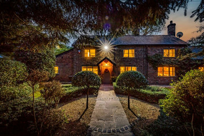
- Price
- £1,999,995
- Size
- 5 acres
Wash Lane, Allostock, WA16, Allostock, Cheshire West and Chester WA16 England
Added on 28/01/2026Equestrian property