Llanteg, Narberth
- Land size
- 5.54 acres
- Bedrooms
- 4
- Bathrooms
- 2
Key Features
- Farmhouse With Outbuildings And Workshop
- Development Opportunity
- 5.54 Acres Approx
- Four Bedrooms
- Chain Free
- Ample Off Road Parking
- LPG Central Heaing
- Close To Coast
- Popular Village Location
- EPC Rating: E
Description
** NO ONWARD CHAIN** This delightful character farmhouse situated in approximately 5.54 acres is located in the sought-after area of Llanteg. Just a short drive from the popular seaside resorts of Tenby and Saundersfoot, Amroth and its lovely sandy beach is only 1.5 miles away.
Bevelyn Farm would make an ideal family home and offers versatile accommodation. There is potential to enhance and/or develop the various outbuildings within the grounds, (with the necessary planning consents) and has the scope and space to create any number of lifestyle choices. This detached home briefly comprises; entrance hall/boot room, country kitchen/breakfast room, dining area, home office, lounge with multi-fuel stove and exposed beams, and sunroom on the ground floor. Stairs from the lounge lead you up to four bedrooms one of which is en-suite and a family-sized bathroom. The property benefits from a classic neutral decor throughout, and has LPG gas central heating.
Externally, the stone outbuilding on one side of the farmyard, originally the old dairy, is in 3 sections and is a perfect project for development, or stables. A 44' block outbuilding sits opposite and is currently being used as a home business workshop. At the bottom of the yard, there is also a 40' farm barn with a lean-to at the rear. Alongside this, there is a fenced-off, hard-core static caravan pitch with connections to water and a private drainage system. Set in approx 5.54 acres which is split over three paddocks, and the surrounding mature gardens, the main garden also houses a patio area which provides space for outside seating. Viewing is highly recommended to appreciate the lifestyle opportunities at Bevelyn Farm and its location in the most beautiful Pembrokeshire countryside.
Llanteg is situated just outside the National Park but within walking distance of the stunning Pembrokeshire coastline near Amroth, and only a short drive to the seaside resorts of Tenby and Saundersfoot.
Workshop - 13.46m x 5.82m (44'2 x 19'1) -
Old Dairy - lhs 4.09m x 3.68m, middle 6.20m x 3.84m, rhs 6.38m - 3 SECTIONS - LHS 13'5 X 12'1, MIDDLE 20'4 X 12'7, RHS 20'11 X 15'2
Barn - 12.27m x 10.36m (40'3 x 34') -
Barn Lean-To - 2.24m x 8.38m (7'4 x 27'6) -
VIEWING: By appointment only via the Agents.
TENURE: We are advised Freehold
SERVICES: We have not checked or tested any of the services or appliances at the property.
COUNCIL TAX: Band 'G'
HEATING: Gas
ref: ADD /LLE /JUN/ 24
TAKEONOK/16/06/24/LLE
FACEBOOK & TWITTER
Be sure to follow us on Twitter: @ WWProps
Map Location
Property details
- Tenure
- Freehold
- Council Tax Band
- G
- Date Posted
- 2026-01-29
Market Value Analysis
Compared with 365 Homes with Land listings in Wales (5+ acres).
Energy Performance Certificate
Energy Efficiency Rating
Based on UK Energy Performance Certificate standards (EU Directive 2002/91/EC)
Running costs are one side. Planning activity, flood history and ground risks for this location are in the full report.
Utilities & Restrictions
Utilities
- Electricity
- Ask Agent
- Water
- Ask Agent
- Heating
- Ask Agent
- Broadband
- Ask Agent
- Sewerage
- Ask Agent
Rights & Restrictions
- Public Rights of Way
- Ask Agent
- Private Rights of Way
- Ask Agent
- Listed Property
- Ask Agent
- Restrictions
- Ask Agent
Listed status, conservation areas and planning constraints for this location are in the full report.
Property Features
- Accessibility
- Ask Agent
- Parking
- Parking Available
- Garden
- Garden
Beyond the particulars: planning activity, flood history, heritage and ground risks, checked for this exact spot.
Connectivity
Broadband
Fastest speed available at this postcode
1.8 Gbps
Gigabit full fibre · available to 89% of premises
Suitable for
- 4K streaming on every screen
- Full-time home working
- Online gaming & big downloads
Mobile signal
Predicted 4G and 5G signal; indoor signal depends on building materials.
Ofcom Connected Nations postcode-level predictions. Speeds and signal are modelled, not measured, and vary between addresses and providers.
Signal is the easy part. Planning activity, flood history and protected designations here are in the full report.
Nearest Schools
Primary
- Tavernspite Community Primary School1.5 miles
- Pupils
- 208
- Type
- Nursery, Infants & Juniors
- Language
- English medium school / provision
- Stepaside Community Primary School3.6 miles
- Pupils
- 119
- Type
- Nursery, Infants & Juniors
- Language
- English medium school / provision
- Templeton Community Primary School4.1 miles
- Pupils
- 126
- Type
- Nursery, Infants & Juniors
- Language
- English medium school / provision
- Saundersfoot Community Primary School4.1 miles
- Pupils
- 172
- Type
- Nursery, Infants & Juniors
- Language
- English medium school / provision
- Llys Hywel4.3 miles
- Pupils
- 135
- Type
- Infants & Juniors
- Language
- Dual language school / provision (Welsh and English) (including transitional)
Secondary
- Dyffryn Taf4.4 miles
- Pupils
- 890
- Type
- Secondary (ages 11-19)
- Language
- Dual language school / provision (Welsh and English) (including transitional)
- Ysgol Greenhill School6.8 miles
- Pupils
- 877
- Type
- Secondary (ages 11-19)
- Language
- English medium school / provision
- Ysgol Harri Tudur / Henry Tudor School13 miles
- Pupils
- 1,152
- Type
- Secondary (ages 11-19)
- Language
- English medium school / provision
- Ysgol Caer Elen14 miles
- Pupils
- 907
- Type
- Middle (ages 3-16)
- Language
- Welsh medium school / provision (including transitional)
- Ysgol Bro Preseli14 miles
- Pupils
- 932
- Type
- Middle (ages 3-19)
- Language
- Welsh medium school / provision (including transitional)
Distances are straight-line from the advertised location. Source: the national school registers (DfE, Welsh Government, Scottish Government) and Ofsted.
Schools are just the start: sold prices nearby, planning activity and any flood history are in the full report.
Amenities
Supermarket
GP surgery
Pharmacy
Straight-line distances from the advertised location. Sources: NHS records, Geolytix supermarket locations, OS Open Greenspace and the national trails registers.
The area stacks up? Now check the location itself: planning nearby, protected designations and past flooding.
Getting Around
Nearest station
Nearest bus stop
Typical drive times
Straight-line distances from the advertised location; drive times are typical free-flow times over OpenStreetMap road data, so allow more at peak. Public transport locations from DfT NaPTAN.
Easy to reach matters. So do planning activity, flood history and ground risks: all in the full report.
Flood Risk
Natural Resources Wales open data, checked around the advertised map pin for the listed acreage. Long-term risk counts flood defences; the planning map's flood zones do not. Provided by LandSale, not the listing agent, and not part of the agent's particulars. Risk varies across a holding, so verify before committing.
Rivers and the sea
Planning map: Flood Zone 1.
Surface water
Not at the pin: mapped about 60 metres away.
These bandings are the summary. Where this location sits on the flood maps, plus planning activity, heritage and ground risks, is in the full report.
Important notice: Information, maps and tags on this page are drawn from the advertising agent's marketing materials or generated automatically. LandSale has not verified them. Relying on these details is at your own risk, always carry out independent checks before committing to a purchase.
LandSale full disclaimer
Marketing information only - not formal particulars. The details on this website are provided for general guidance and do not constitute an offer or contract. Neither LandSale nor the advertising estate/land agent accepts responsibility for any inaccuracy.
1. Source of information
- Listing content: Core description, asking price, tenure, measurements, photographs and planning history originate from the marketing materials of the advertising estate or land agent. LandSale does not author this content and cannot guarantee its accuracy.
- Automated tags & categorisation: Property type, land-use class, acreage bands and similar labels may be applied by machine-learning models. They are intended as a helpful guide only and may not reflect the property's legal status or permitted use.
- Third-party & enriched data layers: Maps, boundary outlines, planning designations, soil reports, broadband coverage and other environmental or location-based insights are licensed from external suppliers. Such data are supplied “as is", may be incomplete or out of date and are subject to change without notice.
2. Verification required
Prospective purchasers must verify critical matters, including but not limited to planning permission, title boundaries, public rights of way, environmental constraints, acreage, services, access and VAT status, through their own inspections, specialist surveys, legal advisers and the selling agent before relying on the information or entering into any contract.
3. No warranty or liability
LandSale gives no warranty, express or implied, as to the accuracy, completeness or fitness for any particular purpose of the information displayed. LandSale shall not be liable for any loss, damage, cost or expense arising directly or indirectly from any use of or reliance on such information, save where liability may not be excluded by law.
4. Updates & feedback
If you believe any detail on this listing is inaccurate, please let us know. We will investigate and, where appropriate, update the listing or notify the agent.
© LandSale | Version 1.3 - August 2026
Listing agent
West Wales Properties, Tenby
Nat West Chamber Tudor Square Tenby SA70 7AJ
View agent profileSimilar properties for sale
- Price
- Offers in Region of£695,000
- Size
- 8 acres
Added on 26/07/2026House with Land
- Price
- £675,000
- Size
- 8 acres
Efail Y Banc, Rhydargaeau Road, Carmarthen, SA32, Carmarthen, Carmarthenshire SA32 Wales
Added on 10/04/2026Country Home
- Price
- £500,000
- Size
- 5 acres
Dre-Fach Felindre, Llandysul, Llangeler, Carmarthenshire SA44 Wales
Added on 20/03/2026House with Land
- Price
- Offers in Region of£725,000
- Size
- 2.16 acres
St. Dogmaels, Cardigan, St. Dogmaels, Pembrokeshire SA43 Wales
Added on 03/07/2026House with Land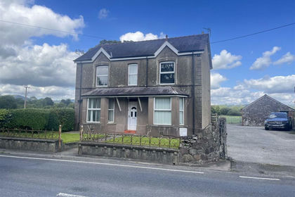
- Price
- £500,000
- Size
- 28 acres
Llangadog, Towy Valley, Llangadog, Carmarthenshire SA19 Wales
Added on 29/01/2026Smallholding