Par Moor Road, St Austell
- Land size
- 1 acres
Key Features
- Unique investment opportunity
- 1 acre site with a block of 16 multi-let rentable units and generous parking provision
- Full Planning Permission to construct 25 new commercial units
- Full Planning Permission to create a new vehicular access from Cypress Avenue (planning activated)
- Located in St Austell Bay Business Park
- Potential for alterative redevelopment subject to the necessary planning consent
- Situated in a strategic location just off the A390 and A3082
Description
Rare investment opportunity to acquire site with a block of 16 multi-let rentable units with permissions for redevelopment and new vehicular access set in the Popular St Austell Bay Business Park.
For Sale by Public Auction on the 23 October 2025
Situation - Cypress House benefits from excellent access to several major road links, making it a highly accessible location for businesses. Par Moor Road itself connects directly to the A390, one of Cornwall's primary arterial routes, linking St Austell to the nearby town of Liskeard and city of Truro. The recently completed St Austell to A30 Link Road, provides fast and much improved access to the A30, a critical route linking Cornwall to the rest of the UK. Additionally, the A3082 provides a scenic route to the charming coastal town of Fowey, enhancing both business accessibility and regional appeal. These comprehensive road networks not only ensure superior accessibility but also positions Cypress House as a prestigious address for discerning businesses seeking a strategic foothold in one of Cornwall's most vibrant commercial areas.
The Existing Property - This prime industrial property, located within the thriving St Austell Bay Business Park, offers an exceptional investment opportunity. Built in 1997 and set in approximately 1 acre; the site combines modern office spaces with versatile workshops, offering a well-rounded environment for various business operations. The property includes 13 modern multi size office units designed to accommodate various business needs. Each office is ready for immediate use and maintained to a high standard. There are also 3 spacious workshops, each fitted with roller doors providing flexible space for industrial activities, storage or other commercial uses. The building includes comprehensive amenities such as an on-site dedicated meeting room that has been recently redecorated and offers a professional environment, well-maintained toilet facilities including multiple cubicles in both the ladies ' and men's toilets, and a fully accessible disabled toilet. Outside, the building is further enhanced by garden areas located to the north and east elevation and to the front of the building there is a generous parking provision.
The site is conveniently accessed by the main entrance of the popular St Austell Bay Business Park and is in close proximity to well established businesses including Toolstation, Brewers Decorator Centre, Screwfix, Westcountry and Spearfishing UK and therefore is perfectly positioned for success in a thriving commercial hub.
Tenure - The building is subject to a 5 year lease, to a company owned by the vendors, for the letting of several offices and workshop units ending on the 31 October 2028 and generates an income of £10,800 per annum. The vendors are agreeable to an early surrender of the lease if required. Please contact the lead agent for further details.
Planning - Full Planning Permission has been granted for the redevelopment of the site, allowing for the demolition of the existing building and the construction of 25 new commercial units arranged in four separate terraced blocks. Each unit benefits from Use Class E and features a mezzanine floor with a total floor area of 62.8sq.m. On the ground floor, every unit is designed with a kitchen, toilet and workshop area, ensuring functionality and convenience for a wide range of business operations. There is also Full Planning Permission (planning activated) to construct a new direct vehicular access from Cypress Avenue. This redevelopment offers a rare investment opportunity to create contemporary, versatile commercial spaces in a strategically located site. The site has potential for alternative redevelopment opportunities subject to obtaining necessary consents.
Services - The site is connected to mains 3-phase electric, mains water and mains drainage. The building benefits from a built in camera system with cameras installed in several of the multi-size offices, an alarm system managed by an external company and outdoor security lights. The individual units within the building benefit from sub meter electric.
Business Rates - Interested parties are advised to make their own enquiries with the Local Authority to ascertain the rates payable.
Local Authority - Cornwall Council
Location - What3Words: ///movies.disposal.bypasses
Solicitors - Nash & Co Solicitors
Beaumont House, PL4 9BD
Agents Notes - Demolition of existing industrial unit and erection of commercial buildings: Ref No.: PA23/04374. Construction of new vehicular access Ref No.: PA22/00415. There is broadband available and mobile coverage in the area, please refer to Ofcom’s website for more details.
Code For Leasing Business Premises - The Code for Leasing Business Premises in England and Wales strongly recommends you seek professional advice from a qualified surveyor, solicitor or licenced conveyancer before agreeing or signing a business tenancy agreement. The Code is available through professional institutions and trade associations or through the website:
Finance Act 1989 - Unless otherwise stated, all prices and rents are quoted exclusive of Value Added Tax (VAT). Any intending purchasers or lessees should satisfy themselves independently as to VAT in respect of any transaction.
Viewing - Viewing is strictly by appointment only, please contact sole agents Symonds & Sampson on
Map Location
Property details
- Tenure
- Freehold
- Council Tax Band
- Ask Agent
- Date Posted
- 2026-01-29
Utilities & Restrictions
Utilities
- Electricity
- Ask Agent
- Water
- Ask Agent
- Heating
- Ask Agent
- Broadband
- Ask Agent
- Sewerage
- Ask Agent
Rights & Restrictions
- Public Rights of Way
- Ask Agent
- Private Rights of Way
- Ask Agent
- Listed Property
- Ask Agent
- Restrictions
- Ask Agent
Listed status, conservation areas and planning constraints for this location are in the full report.
Property Features
- Accessibility
- Ask Agent
- Parking
- Parking Available
- Garden
- Garden
Beyond the particulars: planning activity, flood history, heritage and ground risks, checked for this exact spot.
Connectivity
Broadband
Fastest speed available at this postcode
1 Gbps
Gigabit full fibre · available to 66% of premises
Suitable for
- 4K streaming on every screen
- Full-time home working
- Online gaming & big downloads
Mobile signal
Predicted 4G and 5G signal; indoor signal depends on building materials.
Ofcom Connected Nations postcode-level predictions. Speeds and signal are modelled, not measured, and vary between addresses and providers.
Signal is the easy part. Planning activity, flood history and protected designations here are in the full report.
Nearest Schools
Primary
- Biscovey Academy0.7 milesOfsted: Good *
- Ages
- 7 to 11
- Pupils
- 198
- Type
- Academy converter
- Biscovey Nursery and Infants' Academy0.7 milesNo Ofsted rating
- Ages
- 2 to 7
- Pupils
- 150
- Type
- Academy converter
- Charlestown Primary School0.9 milesOfsted: Good *
- Ages
- 4 to 11
- Pupils
- 372
- Type
- Academy converter
- Bishop Bronescombe CofE School1 mileOfsted: Good
- Ages
- 2 to 11
- Pupils
- 267
- Type
- Academy converter
- Faith
- Church of England
- Sandy Hill Academy1.5 milesNo Ofsted rating
- Ages
- 3 to 11
- Pupils
- 455
- Type
- Academy converter
Secondary
- Penrice Academy1.5 milesOfsted: Outstanding *
- Ages
- 11 to 16
- Pupils
- 1,405
- Type
- Academy converter
- Poltair School2.2 milesOfsted: Good
- Ages
- 11 to 16
- Pupils
- 882
- Type
- Academy sponsor led
- Fowey River Academy4.2 milesOfsted: Good *
- Ages
- 11 to 16
- Pupils
- 676
- Type
- Academy sponsor led
- Brannel School6.8 milesOfsted: Good
- Ages
- 11 to 16
- Pupils
- 888
- Type
- Academy sponsor led
- Bodmin College8.1 milesOfsted: Requires improvement *
- Ages
- 11 to 18
- Pupils
- 1,236
- Type
- Academy converter
* Latest graded judgement covers quality of education only; no overall grade was issued under the 2024-25 inspection framework.
Distances are straight-line from the advertised location. Source: the national school registers (DfE, Welsh Government, Scottish Government) and Ofsted.
Schools are just the start: sold prices nearby, planning activity and any flood history are in the full report.
Amenities
Supermarket
GP surgery
Pharmacy
Hospital
Green space
Walking trail
Straight-line distances from the advertised location. Sources: NHS records, Geolytix supermarket locations, OS Open Greenspace and the national trails registers.
The area stacks up? Now check the location itself: planning nearby, protected designations and past flooding.
Getting Around
Nearest station
Nearest bus stop
Typical drive times
Straight-line distances from the advertised location; drive times are typical free-flow times over OpenStreetMap road data, so allow more at peak. Public transport locations from DfT NaPTAN.
Easy to reach matters. So do planning activity, flood history and ground risks: all in the full report.
Flood Risk
From Environment Agency flood map open data, checked around the advertised map pin and allowing for the listed acreage where known. This summary comes from LandSale, the advertising platform, not from the listing agent, and is not part of the agent's particulars. Risk can vary across a single holding, so verify anything critical through your own searches before committing.
Rivers and the sea
Also mapped within the area searched, about 40 metres around the pin: Flood Zone 2 from about 10 metres and Flood Zone 3 from about 10 metres.
Higher risk nearbySurface water
Also mapped within the area searched, about 40 metres around the pin: a 1 in 30 or greater chance each year from about 10 metres and a 1 in 100 to 1 in 1000 chance each year from about 10 metres.
Higher risk nearbyThese bandings are the summary. Where this location sits on the flood maps, plus planning activity, heritage and ground risks, is in the full report.
Important notice: Information, maps and tags on this page are drawn from the advertising agent's marketing materials or generated automatically. LandSale has not verified them. Relying on these details is at your own risk, always carry out independent checks before committing to a purchase.
LandSale full disclaimer
Marketing information only - not formal particulars. The details on this website are provided for general guidance and do not constitute an offer or contract. Neither LandSale nor the advertising estate/land agent accepts responsibility for any inaccuracy.
1. Source of information
- Listing content: Core description, asking price, tenure, measurements, photographs and planning history originate from the marketing materials of the advertising estate or land agent. LandSale does not author this content and cannot guarantee its accuracy.
- Automated tags & categorisation: Property type, land-use class, acreage bands and similar labels may be applied by machine-learning models. They are intended as a helpful guide only and may not reflect the property's legal status or permitted use.
- Third-party & enriched data layers: Maps, boundary outlines, planning designations, soil reports, broadband coverage and other environmental or location-based insights are licensed from external suppliers. Such data are supplied “as is", may be incomplete or out of date and are subject to change without notice.
2. Verification required
Prospective purchasers must verify critical matters, including but not limited to planning permission, title boundaries, public rights of way, environmental constraints, acreage, services, access and VAT status, through their own inspections, specialist surveys, legal advisers and the selling agent before relying on the information or entering into any contract.
3. No warranty or liability
LandSale gives no warranty, express or implied, as to the accuracy, completeness or fitness for any particular purpose of the information displayed. LandSale shall not be liable for any loss, damage, cost or expense arising directly or indirectly from any use of or reliance on such information, save where liability may not be excluded by law.
4. Updates & feedback
If you believe any detail on this listing is inaccurate, please let us know. We will investigate and, where appropriate, update the listing or notify the agent.
© LandSale | Version 1.3 - August 2026
Listing agent
Symonds & Sampson, Dorchester
Burraton House, 5 Burraton Square, Poundbury, Dorset, DT1 3GR
View agent profileSimilar properties for sale
 Added on 29/01/2026Pub
- Price
- Guide Price£725,000
- Size
- 0.79 acres
Old Station Yard, Berrycoombe Road, Bodmin, Cornwall, PL31, Bodmin, Cornwall PL31 England
Added on 10/09/2026Commercial Land
- Price
- Guide Price£745,000
- Size
- 0.23 acres
Added on 17/07/2026Industrial Land
- Price
- £850,000
- Size
- 0.53 acres
Prince Albert House, Liskeard Business Park, Liskeard, Liskeard, Cornwall PL14 England
Added on 12/05/2026Warehouse
- Price
- Offers in Region of£899,950
Added on 17/07/2026Commercial Land
- Price
- £900,000
Unit A Trecerus Industrial Estate, Padstow, Cornwall, PL28, Padstow, Cornwall PL28 England
Added on 17/07/2026Warehouse
- Price
- Offers in Excess of£750,000
Mariners, 4 Grove Place, Falmouth, Cornwall, TR11, Falmouth, Cornwall TR11 England
Added on 24/06/2026Pub
- Price
- Offers in Excess of£900,000
Devonport Inn, The Cleave, Kingsand, Torpoint, Maker-with-Rame, Cornwall PL10 England
Added on 29/01/2026Pub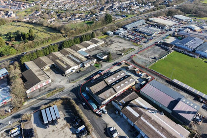
- Price
- Guide Price£750,000
- Size
- 0.29 acres
Added on 29/01/2026Warehouse