Flatts Farm and barnhouse, Main Road, Darley Bridge
- Land size
- 75.14 acres
- Bedrooms
- 5
- Bathrooms
- 3
Key Features
- A productive and well-managed dairy and livestock farm
- A spacious detached three-bedroom farmhouse
- With attractive two-bedroom agricultural workers’ dwelling
- Approximately 75.14 acres of productive flat mowing and grazing land
Description
Flatts Farm presents a rare opportunity to acquire a productive and well-managed dairy and livestock farm comprising a spacious detached three-bedroom farmhouse, an attractive two-bedroom agricultural workers’ dwelling a range of buildings including those suited to conversion, and approximately 75.14 acres of productive land.
Guide Price: £1,765,000
An additional 32.3 acres are available under separate negotiation.
Flatts Farm Summary - Flatts Farm offers a well-established livestock and dairy farm with flexible accommodation and excellent productive pasture land.
The farmhouse is a detached three-bedroom property with the benefit of an attractive two-bedroom barn conversion. The holding benefits from highly productive grassland, until recently managed as a productive dairy unit, latterly used for suckler beef production. The land is flat, fertile and offers excellent mowing and grazing pasture.
Location - Flatts Farm is situated on the outskirts of Darley Bridge, a village located between Matlock and Bakewell, in the heart of the Derbyshire Dales only minutes from the Peak District.
Whilst in a lovely rural position, the property affords a very accessible rural location with ready access to Matlock (2.9 miles), Bakewell (6.5 miles) and major road networks. The farm is only 10 miles from Chesterfield and 21.2 miles from Derby.
Matlock has a train station offering intercity trains to London and a wide range of amenities. There is a good selection of local primary schools with both South Darley Primary School and Churchtown C of E primary being within 2 miles and rated ‘Good’ by OFSTED. Stanton in Peak C of E Primary is just 3.5 miles away and is rated ‘Excellent’. The well regarded local secondary schools are Lady Manners School in Bakewell and Highfields School in Matlock.
Background - The farm has been within the vendors family since 1939, and has been owned and farmed by him for the last forty years, operated as a successful dairy unit. The milking herd was 80 cows, but with the vendor reaching retirement, he has reduced the milking herd and has kept beef cattle in recent months. The farm has been managed to the highest level.
Farmhouse - The large, three bedroom detached double fronted farmhouse provides lovely flexible living accommodation overlooking the farm and sat within an attractive garden.
The accommodation is well appointed, spacious and is arranged over two storeys with three large double bedrooms, and scope for additional rooms in the roof space subject to the necessary consents. The farmhouse is very well finished and has lovely high ceilings throughout, affording large bright rooms making it a very appealling prospect.
The main Entrance Hall affords access to all of the principal ground floor rooms, that include the large triple aspect Sitting Room that runs the full length of the house. Access is afforded to the spacious double aspect Dining Room and the large double aspect Kitchen Diner that accommodates an extensive range of fitted timber wall and base units with a number of integrated appliances, and benefitting from far reaching views over the fields beyond making it a wonderful heart of the home, with a useful cloakroom off. From the Kitchen is a good sized glazed Entrance/Utility area with a range of fitted base units with WC off, and external access that has been used as the primary access into the property.
From the front Entrance Hall the spacious staircase leads to the first floor, with a central landing that in turn leads to three large double bedrooms, family bathroom and study. A loft ladder leads into the roof space that offers scope for further rooms if required subject to the necessary consents.
The Barnhouse - This attractive stone barn conversion was completed in 1991 and is very well finished, boasting views across the fields and yard.
The two-bedroom agricultural workers’ dwelling is well situated and has been let out by the current owners to the existing tenant since August 2013.
After entering the Entrance Porch, the Hallway in turn leads to a large Kitchen Diner, Living Room, Family Bathroom and Double Bedroom. In addition to the ground floor accommodation is a Double Bedroom with Ensuite located on the first floor, together with additional storage. Adjoining the Barnhouse are outside stores that could be used to extend the Barnhouse accommodation (subject to necessary consents) or offer additional storage.
Occupancy Condition - The occupation of the Barnhouse is limited to a person solely or mainly employed, or last employed (prior to retirement), in the locality in agriculture as defined in section 290 (1) of the Town and Country Planning act 1971 (including any dependants of such a person residing with him) or a widow or widower of such a person.
Buildings And Facilities - Flatts Farm offers a good range of both traditional and modern agricultural buildings largely located at the farmstead, and based around concretes yard areas. The traditional stone range provides scope for conversion to other uses (subject to planning). The more modern buildings are well suited to farming operations, supporting the dairy operation, and latterly beef cattle, and may well be suited to other non agricultural uses subject to planning.
The buildings can be briefly summarised as follows, with reference to the numbered plan.
1.Single storey stone range, with blue slate over, blockwork internal skin and concrete floor, accommodating the 10:10 herringbone parlour, collecting yard and dairy (35.2m x 6.45m GEA). This building offers considerable scope for conversion for alternative uses, subject to the necessary consents, or to recommence dairy farming.
2.Three bay steel frame monopitch implement store with box profile sheet and concrete block cladding and floor (5.0m x 8.7m, 10.6m x 5.6m GEA).
3.Three bay open fronted Dutch barn, with steel frame monopitch at the rear, used for cattle handling and as an implement store (13.1m x 12.8 m GEA)
4.Single storey rendered brick cattle building with corrugated grey fibre cement over and concrete floor (3.6m x 17.3m GEA)
5.Six bay steel portal framed cubicle shed with timber and box profile sheet cladding and concrete floor (28.4m x 6.4 GEA).
6.Timber framed building with box profile sheet roof over and concrete floor accommodating 64 cow kennels (30.7 x 14.8 m GEA)
7.Five bay steel portal framed implement and forage shed with Yorkshire board and box profile cladding and stone floor (23.0m x 15.1m GEA)
Steel framed two bay open fronted implement store (9.5m x 7.5m GEA).
The holding benefits from an above ground three ring steel slurry store with c. 88,000 gallon capacity, with further below ground storage of c. 20,000 gallons.
In addition, lying to the east of the farmstead is an in field four bay Dutch barn (18.5m x 5.6m GEA) currently used as an implement and forage shed. A further single storey stone barn with stone slate over is located further to the east, overlooking the river (9.4m x 3.6m GEA).
Land - The holding comprises approximately 75.14 acres of very productive grassland that has been managed to a high standard, being well suited for mowing and grazing, with three cuts typically being taken.
The land is generally flat, readily accessible, has good sized fields and is over deep freely draining floodplain soils that have a loamy texture and have naturally moderate to high fertility (Soilscape 12). The land has access to both natural and mains water.
Lotting - The property is offered as a whole or in two lots. Please note that Lot 1 will need to have been sold before a separate sale of Lot 2 is considered.
Lot 1 comprises the residential properties farmstead, buildings and 72.16 acres (shown tinted PINK on the Holding Plan). There is additional land available separately, totalling 32.6 acres of land, similarly all suitable for mowing and grazing.
Flooding - The farm is situated adjacent to the River Derwent and includes land classified as being within Flood Zone 3, while the majority of the farmstead lies within Flood Zone 2.
Seasonal flooding can occasionally occur when the River Derwent overtops its banks or when the river level exceed the field drainage outfall height. On such occasions, livestock will likely need to be temporarily removed from the affected fields. However, the land benefits from an extensive system of field drains, allowing it to recover and dry out quickly once river levels recede.
The property has been in the vendors’ family since 1939, with the current owners having held it for more than 40 years. Despite its proximity to the river, the vendors confirm that the residential dwellings have never experienced flooding during this time. There have also been no difficulties in obtaining buildings and contents insurance. The farm buildings have similarly remained unaffected, with the exception of the eastern edge of Building 7.
For prospective purchasers with concerns about flooding, the vendors are happy to provide further details and discuss their experience during any arranged viewing.
Services - Both the Farmhouse and the Barnhouse benefit from mains water, gas and electric. The farm has three phase electricity. Domestic drainage is via private systems, though a connection is possible to the mains nearby if desired
Rights Of Way, Wayleaves & Easements - The property is sold subject to and with the benefit of all existing rights of way, wayleaves, and easements.
Timber, Minerals & Sporting Rights - Included insofar as they exist. Fishing rights are excluded.
Fixtures, Fittings & Plan - Only those referred to in these particulars are included in the sale
Tenure And Possession - The property is offered freehold with vacant possession on completion, excepting only the Barnhouse that is currently occupied on a periodic Assured Shorthold Tenancy, with a current rent passing of £440 per calendar month. Should the purchaser wish to resume possession, two months written notice will need to be served by the Landlord.
Council Tax & Epc - Both the Farmhouse and the Barnhouse are separately registered with Derbyshire Dales District Council as Council Tax Band D
The Farmhouse has an EPC rating of 62 (Energy rating ‘D’), the Barnhouse has an EPC rating of 52, (Energy Rating ‘E’).
Local Authority: - Derbyshire Dales District Council
A| Town Hall, Bank Road, Matlock, Derbyshire DE4 3NN
T|
E|
Solicitor - Lovedays Solicitors (Mr. Glenn McClenaghan)
A| Aldern House, Baslow Road, Bakewell, Derbyshire DE45 1AE
T|
E|
Viewing - Strictly by appointment only through the selling agents Bagshaws at the Bakewell Office on .
Broadband Connectivity - Fibre broadband is connected to the farmhouse However, please note that connection speeds may vary. For an estimated broadband coverage, prospective purchasers are advised to consult
Mobile Network Coverage - The property is well-situated for mobile signal coverage and is expected to be served by a broad range of providers. Prospective purchasers are encouraged to consult the Ofcom website ( to obtain an estimate of the signal strength for this specific location.
Agents Notes - Bagshaws LLP have made every reasonable effort to ensure these details offer an accurate and fair description of the property. The particulars are produced in good faith, for guidance only and do not constitute or form an offer or part of the contract for sale. Bagshaws LLP and their employees are not authorised to give any warranties or representations in relation to the sale and give notice that all plans, measurements, distances, areas and any other details referred to are approximate and based on information available at the time of printing.
Map Location
Property details
- Tenure
- Freehold
- Council Tax Band
- D
- Date Posted
- 2026-01-29
Market Value Analysis
Compared with 54 listings of all property types in East Midlands (75+ acres).
Energy Performance Certificate
Energy Efficiency Rating
Based on UK Energy Performance Certificate standards (EU Directive 2002/91/EC)
Running costs are one side. Planning activity, flood history and ground risks for this location are in the full report.
Utilities & Restrictions
Utilities
- Electricity
- Mains
- Water
- Mains
- Heating
- Gas Central Heating
- Broadband
- Ask Agent
- Sewerage
- Septic Tank / Private
Rights & Restrictions
- Public Rights of Way
- Ask Agent
- Private Rights of Way
- Ask Agent
- Listed Property
- Ask Agent
- Restrictions
- Ask Agent
Listed status, conservation areas and planning constraints for this location are in the full report.
Property Features
- Accessibility
- Ask Agent
- Parking
- Off-Street Parking
- Garden
- Garden
Beyond the particulars: planning activity, flood history, heritage and ground risks, checked for this exact spot.
Connectivity
Broadband
Fastest speed available at this postcode
1.8 Gbps
Gigabit full fibre · available to 31% of premises
Suitable for
- 4K streaming on every screen
- Full-time home working
- Online gaming & big downloads
Mobile signal
Outdoor predictions; indoor signal depends on building materials.
Ofcom Connected Nations postcode-level predictions. Speeds and signal are modelled, not measured, and vary between addresses and providers.
Signal is the easy part. Planning activity, flood history and protected designations here are in the full report.
Nearest Schools
Primary
- South Darley CofE Primary School602 metresNo Ofsted rating
- Ages
- 5 to 11
- Pupils
- 54
- Type
- Voluntary controlled school
- Faith
- Church of England
- Darley Churchtown Church of England Primary School0.7 milesOfsted: Good
- Ages
- 4 to 11
- Pupils
- 41
- Type
- Academy converter
- Faith
- Church of England
- Darley Dale Primary School0.8 milesOfsted: Good
- Ages
- 3 to 11
- Pupils
- 214
- Type
- Community school
- All Saints CofE Junior School1.5 milesOfsted report card · Apr 2026
- Ages
- 7 to 11
- Pupils
- 218
- Type
- Academy converter
- Faith
- Church of England
- Winster CofE Primary School1.8 milesNo Ofsted rating
- Ages
- 4 to 11
- Pupils
- 4
- Type
- Voluntary controlled school
- Faith
- Church of England
Secondary
- Highfields School2.6 milesNo Ofsted rating
- Ages
- 11 to 18
- Pupils
- 1,298
- Type
- Academy converter
- Lady Manners School5 milesOfsted: Good
- Ages
- 11 to 18
- Pupils
- 1,405
- Type
- Foundation school
- Anthony Gell School5.4 milesNo Ofsted rating
- Ages
- 11 to 18
- Pupils
- 776
- Type
- Academy converter
- Brookfield Community School7.5 milesOfsted: Good
- Ages
- 11 to 18
- Pupils
- 1,156
- Type
- Academy converter
- Tupton Hall School8 milesOfsted: Good
- Ages
- 11 to 18
- Pupils
- 1,581
- Type
- Academy sponsor led
Distances are straight-line from the advertised location. Source: the national school registers (DfE, Welsh Government, Scottish Government) and Ofsted.
Schools are just the start: sold prices nearby, planning activity and any flood history are in the full report.
Amenities
Supermarket
GP surgery
Pharmacy
Hospital
Green space
Straight-line distances from the advertised location. Sources: NHS records, Geolytix supermarket locations, OS Open Greenspace and the national trails registers.
The area stacks up? Now check the location itself: planning nearby, protected designations and past flooding.
Getting Around
Nearest station
Nearest bus stop
Typical drive times
Straight-line distances from the advertised location; drive times are typical free-flow times over OpenStreetMap road data, so allow more at peak. Public transport locations from DfT NaPTAN.
Easy to reach matters. So do planning activity, flood history and ground risks: all in the full report.
Flood Risk
From Environment Agency flood map open data, checked around the advertised map pin and allowing for the listed acreage where known. This summary comes from LandSale, the advertising platform, not from the listing agent, and is not part of the agent's particulars. Risk can vary across a single holding, so verify anything critical through your own searches before committing.
Rivers and the sea
Surface water
Mapped within the area searched, not at the advertised map pin itself.
The detail behind these bandings
The full report pinpoints where this location sits on the flood maps, and runs the deeper checks that usually only surface after an offer.
- Exact flood zones & annual chances (included in the full report)
- Any recorded past flooding (included in the full report)
- Planning activity nearby (included in the full report)
- Heritage & conservation (included in the full report)
- Protected nature designations (included in the full report)
- Ground risks (included in the full report)
- Sold prices nearby (included in the full report)
£14.99 · one-off purchase
By LandSale, the platform. Not provided by the listing agent. Ready in about a minute.
Important notice: Information, maps and tags on this page are drawn from the advertising agent's marketing materials or generated automatically. LandSale has not verified them. Relying on these details is at your own risk, always carry out independent checks before committing to a purchase.
LandSale full disclaimer
Marketing information only - not formal particulars. The details on this website are provided for general guidance and do not constitute an offer or contract. Neither LandSale nor the advertising estate/land agent accepts responsibility for any inaccuracy.
1. Source of information
- Listing content: Core description, asking price, tenure, measurements, photographs and planning history originate from the marketing materials of the advertising estate or land agent. LandSale does not author this content and cannot guarantee its accuracy.
- Automated tags & categorisation: Property type, land-use class, acreage bands and similar labels may be applied by machine-learning models. They are intended as a helpful guide only and may not reflect the property's legal status or permitted use.
- Third-party & enriched data layers: Maps, boundary outlines, planning designations, soil reports, broadband coverage and other environmental or location-based insights are licensed from external suppliers. Such data are supplied “as is", may be incomplete or out of date and are subject to change without notice.
2. Verification required
Prospective purchasers must verify critical matters, including but not limited to planning permission, title boundaries, public rights of way, environmental constraints, acreage, services, access and VAT status, through their own inspections, specialist surveys, legal advisers and the selling agent before relying on the information or entering into any contract.
3. No warranty or liability
LandSale gives no warranty, express or implied, as to the accuracy, completeness or fitness for any particular purpose of the information displayed. LandSale shall not be liable for any loss, damage, cost or expense arising directly or indirectly from any use of or reliance on such information, save where liability may not be excluded by law.
4. Updates & feedback
If you believe any detail on this listing is inaccurate, please let us know. We will investigate and, where appropriate, update the listing or notify the agent.
© LandSale | Version 1.3 - August 2026
Listing agent
Bagshaws, Bakewell
The Agricultural Business Centre, Agricultural Way, Bakewell, DE45 1AH
View agent profileSimilar properties for sale
- Price
- Offers in Region of£1,350,000
- Size
- 196 acres
Gospel Farm, Bramley Lane, Hassop, Bakewell, Hassop, Derbyshire DE45 England
Added on 29/01/2026Farm
- Price
- Guide Price£1,995,000
- Size
- 73.92 acres
Monkwood Farm, Barlow, Dronfield, Barlow, Derbyshire S18 England
Added on 25/04/2026House with Land- Price
- Offers in Region of£1,750,000
- Size
- 50 acres
Monkwood Farm, Barlow, Dronfield, Barlow, Derbyshire S18 England
Added on 07/05/2026House with Land
- Price
- Guide Price£1,515,000
- Size
- 205.57 acres
Added on 17/07/2026Farm
- Price
- Guide Price£2,000,000
- Size
- 213.99 acres
Land and Buildings at Ivy Farm, Kinoulton, Nottinghamshire, Kinoulton, Nottinghamshire NG12 England
Added on 15/03/2026Farmland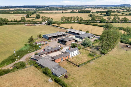
- Price
- Offers in Excess of£1,600,000
- Size
- 76 acres
Added on 11/08/2026Farm