Hensley Hill House, The Farmhouse Known As Hensley Hill, Rathmell, Settle, North Yorkshire, BD24
- Bedrooms
- 3
- Bathrooms
- 2
Key Features
- Detached farmhouse dating back to the 1800s
- Wonderful views
- Kitchen with picture window looking out to Pen-y-ghent
- Three bedrooms
- Parking for approx. 3 cars on driveway
- Barn currently used as a garage
- Wrap around gardens
- Council tax D
- EPC rating D
Description
This charming detached farmhouse, believed to date back to the 1800s, enjoys a truly enviable position with wonderful surrounding views. A particular highlight is the kitchen, which benefits from a picture window framing stunning views towards Pen-y-ghent. The property provides three bedrooms, ample driveway parking for approximately three cars, a substantial barn currently utilised as a garage, and attractive wrap-around gardens, offering a fantastic opportunity to create a beautiful countryside home with plenty of character and potential.
This property is all about the views, location and potential. Situated near the beautiful village of Rathmell near Settle and looking out over Pen-y-ghent and Hesley Moss from the kitchens, bedrooms mezzanine and rear gardens. The Moss is registered as a SSSI with Natural England and has mature woodlands, the footpath runs from the house across the Moss to open countryside walks.
The property currently stands as one full dwelling with the historic farmhouse still with its original features and a study/bedroom on the first floor with a morso squirrel stove. The previous owners 70’s conversion made a large farmhouse that extends into the adjoining converted barns with mezzanine dining areas. This space could be converted to create a fabulous open kitchen/living space with mezzanine dining or a separate apartment to run Air B&B from. Beautiful wrap around gardens providing idyllic seating areas, vegetable growing patches and parking.
The current owner has done considerable work since owning it with various repairs and renovations.
Benefitting from Economy 7 Night storage heaters and has three multi fuel stoves and is described in brief below using approximate room sizes:-
ACCOMMODATION - MAIN HOUSE
GROUND FLOOR
ENTRANCE HALL
A solid wood front door and into a useful and spacious hallway with a tiled floor with plenty of space for boots and coats and access to the garage barn.
SHOWER ROOM
A shower room consisting of walk in shower enclosure, low suite WC and handbasin. Part tiled walls and a heated towel rail.
KITCHEN 12'4" x 8'8" (3.76m x 2.64m)
A dream of a kitchen to wash up in with a picture window with views over to Pen-y-ghent. A built in wood storage unit with inset sink unit and drainer with a maple worktop and a built in dish-washer. A fabulous built in pantry cupboard with wood panelled sliding doors and an Economy 7 Aga with two ovens and a tiled floor.
SITTING ROOM 17'6" x 13'2" (5.33m x 4.01m)
A light and spacious sitting room with dual aspect windows with stunning views and a lovely open, stone fireplace with log burning stove. Stairs to the first floor.
ADJOINING BARN GARAGE 32' x 18' (9.75m x 5.49m)
With large wooden barn doors and stone flagged floor, this barn would make a fabulous open plan kitchen/living space with a mezzanine upper floor currently used as a dining space with fabulous views. It has a stone flagged floor, light and power, and houses the property's water filtration system, wood store and a has a built in workbench. The current owner uses it partly as a garage. Upstairs, a large mezzanine dining space with wooden floor, triple aspect windows to amaze your guests with the stunning views on offer.
FIRST FLOOR
LANDING
Night storage heater.
BEDROOM ONE 16'6" x 11'4" (5.03m x 3.45m)
A generous double bedroom with fabulous dual aspect windows to enjoy the amazing views, wood floor and large built in wardrobes. Electric night storage heater and roof space access.
BEDROOM TWO
A spacious double bedroom currently being used as a study with a picture window to the front with far reaching hill views. Wood floor and an electric night storage heater.
BEDROOM THREE
Wow, this part of the property is just adorable and has so much potential to develop further for a larger family or just keep it as the treasure that it is and use it for guests or Airbnb within the current guidelines.
DINING ROOM 14'1" x 3'3" (4.3m x 1m)
This really is farmhouse living at its truest with stone flagged floor, solid wood beamed ceiling and the original open range with original bread oven and grill fire. A beautiful cottage window to the front with window seat and understairs storage.
KITCHENETTE 6'8" x 6'1" (2.03m x 1.85m)
This fabulous kitchenette area has plumbing and a hot water boiler. Stone floor, original slate shelving and a delightful small window from the traditional sink to the view.
FIRST FLOOR
LANDING
An open landing area with spindle balustrade and wonderful window overlooking the rolling hills and peaks beyond. This area would make an incredible open bathroom with roll top bath to lie back and enjoy the views. Currently used as a bedroom/study area.
BEDROOM 13'4" x 10'5" (4.06m x 3.18m)
A stunning double bedroom with exposed stone wall, open fireplace with morso log burning stove and window to the front.
SMALL STONE BUILDING
The stone built outhouse at the top of the garden was the original outside toilet for the farmhouse. It is an adorable building which could make a perfect pizza oven, camera obscura and has development potential, or just the continued use as a separate wc and garden shed. The garden historically housed a turf house and it is believed that originally this was part of the first house.
EXTERNAL - GARDENS AND PARKING
To the front of the property, access is via a gated entrance from a private track from the road. To a private drive area with parking for three cars and access to the barn currently used as a garage and wood store on the ground floor level, with a 70’s workbench area built into the old stalls.
A multitude of fruit trees and seating areas are amongst the established trees and shrubbery to the front of the property that make it a haven for wildlife. The original stone slabs make a wonderful seating area and original stone walls inset amongst the gardens.
To the rear of the property is an expansive lawned garden area with a secret garden at the top to delight the children in the family, trees, shrubs and elevated seating areas to enjoy the wonderful Yorkshire Peaks views. Raised vegetable beds, pergola covered seating/planting areas and stone built outhouse which would make a perfect pizza oven, camera obscura or just the continued use as a separate wc. Historically the building was the outside wc for the original small farmhouse in the top part of the current extended farmhouse which was developed in the early 70’s.
To the side are wrap around gardens that are based on a Ha ha’s view into the landscape and support a wildlife corridor. The dominant title, Hensley Hill House is shown through the farm house title being the farm title, Hensley Hill with House added in the full title description at A1. It is a special and rare farm house and hill title represented by Hensley Hill on the title plan and mapping. The garden is a stepping stone within agricultural land for birds flying from the Moss to Stocks reservoir further to the north.
VIEWING ARRANGEMENTS
We would be pleased to arrange a viewing for you. Please contact Hardisty's Skipton office. Our opening hours are:- Monday to Friday: 9.00am - 5.30pm Saturday: 9.00am - 4.00pm Sunday: 11.00am - 3.00pm
TENURE
We understand the property to be freehold.
COUNCIL TAX
Craven District Council Tax Band D. For further details on North Yorkshire Council Tax Charges please visit
PLEASE NOTE
The extent of the property and its boundaries are subject to verification by inspection of the title deeds. The measurements in these particulars are approximate and have been provided for guidance purposes only. The fixtures, fittings and appliances have not been tested and therefore no guarantee can be given that they are in working order. The internal photographs used in these particulars are reproduced for general information and it cannot be inferred that any item is included in the sale.
REFERRAL FEE DISCLOSURE
As well as your obligation to pay our commission or fees we may also receive a commission, payment, fee or reward (known as a Referral Fee) from ancillary providers for recommending their service to you. Please see website for full details.
Map Location
Property details
- Tenure
- Freehold
- Council Tax Band
- D
- Date Posted
- 2026-01-29
Energy Performance Certificate
Energy Efficiency Rating
Based on UK Energy Performance Certificate standards (EU Directive 2002/91/EC)
Running costs are one side. Planning activity, flood history and ground risks for this location are in the full report.
Utilities & Restrictions
Utilities
- Electricity
- Ask Agent
- Water
- Ask Agent
- Heating
- Ask Agent
- Broadband
- Ask Agent
- Sewerage
- Ask Agent
Rights & Restrictions
- Public Rights of Way
- Ask Agent
- Private Rights of Way
- Ask Agent
- Listed Property
- Ask Agent
- Restrictions
- Ask Agent
Listed status, conservation areas and planning constraints for this location are in the full report.
Property Features
- Accessibility
- Ask Agent
- Parking
- Parking Available
- Garden
- Garden
Beyond the particulars: planning activity, flood history, heritage and ground risks, checked for this exact spot.
Connectivity
Broadband
Fastest speed available at this postcode
1 Gbps
Gigabit full fibre · available to 8% of premises
Suitable for
- 4K streaming on every screen
- Full-time home working
- Online gaming & big downloads
Mobile signal
Predicted 4G and 5G signal; indoor signal depends on building materials.
Ofcom Connected Nations postcode-level predictions. Speeds and signal are modelled, not measured, and vary between addresses and providers.
Signal is the easy part. Planning activity, flood history and protected designations here are in the full report.
Nearest Schools
Primary
- Giggleswick Primary School3.2 milesOfsted: Good
- Ages
- 4 to 11
- Pupils
- 75
- Type
- Community school
- Settle Church of England Voluntary Controlled Primary School3.2 milesOfsted: Good
- Ages
- 3 to 11
- Pupils
- 188
- Type
- Voluntary controlled school
- Faith
- Church of England
- Long Preston Endowed Voluntary Aided Primary School3.5 milesNo Ofsted rating
- Ages
- 3 to 11
- Pupils
- 53
- Type
- Voluntary aided school
- Faith
- Church of England
- Hellifield Community Primary School4.8 milesOfsted: Good *
- Ages
- 4 to 11
- Pupils
- 77
- Type
- Community school
- Austwick Church of England VA Primary School5.5 milesNo Ofsted rating
- Ages
- 4 to 11
- Pupils
- 53
- Type
- Voluntary aided school
- Faith
- Church of England
Secondary
- Settle College3.3 milesNo Ofsted rating
- Ages
- 11 to 18
- Pupils
- 561
- Type
- Community school
- Bowland High8.5 milesOfsted: Good
- Ages
- 11 to 16
- Pupils
- 644
- Type
- Academy converter
- West Craven High School11 milesOfsted: Requires improvement
- Ages
- 11 to 16
- Pupils
- 528
- Type
- Academy converter
- Clitheroe Royal Grammar School11 milesOfsted: Outstanding
- Ages
- 11 to 18
- Pupils
- 1,496
- Type
- Academy converter
- Ribblesdale School12 milesOfsted: Good *
- Ages
- 4 to 16
- Pupils
- 1,437
- Type
- Community school
* Latest graded judgement covers quality of education only; no overall grade was issued under the 2024-25 inspection framework.
Distances are straight-line from the advertised location. Source: the national school registers (DfE, Welsh Government, Scottish Government) and Ofsted.
Schools are just the start: sold prices nearby, planning activity and any flood history are in the full report.
Amenities
Supermarket
GP surgery
Pharmacy
Hospital
Straight-line distances from the advertised location. Sources: NHS records, Geolytix supermarket locations, OS Open Greenspace and the national trails registers.
The area stacks up? Now check the location itself: planning nearby, protected designations and past flooding.
Getting Around
Nearest station
Nearest bus stop
Typical drive times
Straight-line distances from the advertised location; drive times are typical free-flow times over OpenStreetMap road data, so allow more at peak. Public transport locations from DfT NaPTAN.
Easy to reach matters. So do planning activity, flood history and ground risks: all in the full report.
Flood Risk
Environment Agency open data, checked around the advertised map pin for the listed acreage. Long-term risk counts flood defences; the planning map's flood zones do not. Provided by LandSale, not the listing agent, and not part of the agent's particulars. Risk varies across a holding, so verify before committing.
Rivers and the sea
Planning map: Flood Zone 1.
Surface water
These bandings are the summary. Where this location sits on the flood maps, plus planning activity, heritage and ground risks, is in the full report.
Important notice: Information, maps and tags on this page are drawn from the advertising agent's marketing materials or generated automatically. LandSale has not verified them. Relying on these details is at your own risk, always carry out independent checks before committing to a purchase.
LandSale full disclaimer
Marketing information only - not formal particulars. The details on this website are provided for general guidance and do not constitute an offer or contract. Neither LandSale nor the advertising estate/land agent accepts responsibility for any inaccuracy.
1. Source of information
- Listing content: Core description, asking price, tenure, measurements, photographs and planning history originate from the marketing materials of the advertising estate or land agent. LandSale does not author this content and cannot guarantee its accuracy.
- Automated tags & categorisation: Property type, land-use class, acreage bands and similar labels may be applied by machine-learning models. They are intended as a helpful guide only and may not reflect the property's legal status or permitted use.
- Third-party & enriched data layers: Maps, boundary outlines, planning designations, soil reports, broadband coverage and other environmental or location-based insights are licensed from external suppliers. Such data are supplied “as is", may be incomplete or out of date and are subject to change without notice.
2. Verification required
Prospective purchasers must verify critical matters, including but not limited to planning permission, title boundaries, public rights of way, environmental constraints, acreage, services, access and VAT status, through their own inspections, specialist surveys, legal advisers and the selling agent before relying on the information or entering into any contract.
3. No warranty or liability
LandSale gives no warranty, express or implied, as to the accuracy, completeness or fitness for any particular purpose of the information displayed. LandSale shall not be liable for any loss, damage, cost or expense arising directly or indirectly from any use of or reliance on such information, save where liability may not be excluded by law.
4. Updates & feedback
If you believe any detail on this listing is inaccurate, please let us know. We will investigate and, where appropriate, update the listing or notify the agent.
© LandSale | Version 1.3 - August 2026
Listing agent
Hardisty Prestige, Covering Ilkley, Skipton & Horsforth
Yorkshire
Similar properties for sale
- Price
- Offers in Region of£575,000
A65, Long Preston, BD23, Settle, North Yorkshire BD23 England
Added on 13/02/2026Barn Conversion Added on 29/01/2026Barn Conversion
- Price
- Guide Price£575,000
Malham, Skipton, North Yorkshire, BD23, Malham, North Yorkshire BD23 England
Added on 07/09/2026Barn Conversion
- Price
- £525,000
Thompsons Barn, Horton In Ribblesdale, BD24, Horton in Ribblesdale, North Yorkshire BD24 England
Added on 29/01/2026Barn Conversion
- Price
- £475,000
- Size
- 1 acres
Sawley, Bolton By Bowland, Clitheroe, Lancashire, Grindleton, Lancashire BB7 England
Added on 07/10/2026Conversion Land
- Price
- Offers in Region of£625,000
Lower Chapel Lane, Grindleton, BB7, Grindleton, Lancashire BB7 England
Added on 28/04/2026Barn Conversion
- Price
- Guide Price£389,950
Selside, Settle, North Yorkshire, BD24, Horton in Ribblesdale, North Yorkshire BD24 England
Added on 20/02/2026Barn Conversion
- Price
- Offers in Region of£550,000
1 Green Head Cottage, Cross Lane, Low Bentham, LA2, Bentham, North Yorkshire LA2 England
Added on 20/07/2026Development Land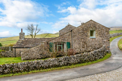
- Price
- Offers in Region of£530,000
Scar End Barn, Ingleton, Carnforth, LA6, Ingleton, North Yorkshire LA6 England
Added on 18/03/2026Barn Conversion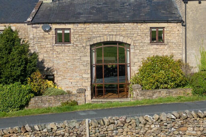 Added on 06/10/2026Barn Conversion