Mill Lane, Fareham, Hampshire, PO15
- Land size
- 7.5 acres
- Bedrooms
- 7
- Bathrooms
- 7
Key Features
- SEE AND PRINT PDF SALES PARTICULARS AVAILABLE BELOW
- SEE DRONE VIDEO FOOTAGE ON THE VIRTUAL TOUR TAB
- 7 BED DETACHED FARMHOUSE (APPROX. 4,809 SQ.FT.)
- EXTENDING TO APPROX. 7.50 ACRES IN ALL
- PASTURE LAND, CURRENTLY CARAVAN & CAMPING SITE (APPROX. 5.25 ACRES)
- SHEPHERDS HUT
- SMALL RANGE OF COMMMERCIAL BUILDING & YARDS
- CLOSE TO RIVER MEON AND TITCHFIELD ABBEY
- WOODLAND OF APPROX. 0.89 ACRES
- POND
Description
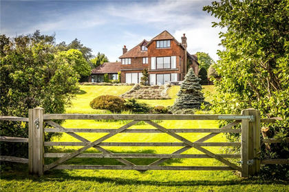
The Property: 'Drove Lea Farm', extending in all to approx. 7.50 acres (3.03 Ha), is a characterful Property, nestled in the scenic Meon Valley within the historic landscape of Titchfield Abbey situated to the south. Dating back to the late 1800s, the farmhouse was once part of the original Titchfield Abbey Estate and features a historic sink, linked to the Abbey's medieval carp pond, which was once used to supply fresh fish to the monastery. The Abbey is know to have strong associations with William Shakespeare. The historic and picturesque village of Titchfield itself is only a short walk away to the south.
The house provides a spacious family home with a Victorian heart (approx. 4,890 ft2/ 446.8m2) surrounded by a country garden. Buildings in use for storage and commercial uses extending to approx. 5,824ft2 /541.1m2, as well as hardstanding and yard space extending to approx. 27,935 ft2 (0.67 acres/0.27 Ha) in use for access and for siting a wood chipping business. The pasture land extends to approx. 5.25 acres (2.12 Ha) and provides a tranquil location for a caravan site and a shepherd's hut . The Property also includes a small area of woodland (Segensworth Copse) extending to approx. 0.89 acres (0.36 Ha), and a pond.
Over the years, Drove Lea Farm has evolved through a variety of uses including as a strawberry farm, then a dairy operation with its own bottling facility, and was even once home to a small local school. Prior to its current use, the land has supported a plant hire company. Today the Property hosts multiple income streams including the caravan/camping site, a shepherd's hut, several rented commercial units and a wood chipping business.
Drove Lea Farm extends in all, to approximately 7.50 acres, as outlined in red on the Site Plan. An approximate summary of the various areas is as follows:
0.69 acres / 0.28 Ha - House, gardens and access and parking
5.25 acres / 2.12 Ha - Pastureland; currently Caravan site and Shepherds Hut
0.67 acres / 0.27 Ha - Buildings and Yards-storage & commercial
0.89 acres / 0.36 Ha - Woodland (Segensworth Copse)
TOTAL 7.50 acres / 3.03 Ha
THE HOUSE (see floor plan)
Ground Floor: Hardwood front door with adjacent stained glass window provides access to the entrance hall in the characterful Victorian heart of the house, with doors to principal living spaces. Roomy triple-aspect sitting room features ceiling beams, log burner with brick surround and French doors opening onto patio. Separate dining room again featuring exposed ceiling beams, brick chimney breast and open fire. Dual aspect family room accessed through dining room with tiled floor and French doors into garden. Generous study with fitted cupboard. Large kitchen/breakfast room with ample worktop space, La Nordica Wood Burning Stove and two sets of French Doors opening onto patio on northern elevation making an excellent space for entertaining. Bathroom with a shower accessed from the hallway and a utility room accessed from the kitchen/breakfast room.
First Floor: The first floor is accessed via a stairway from the entrance hall onto a landing featuring beams in ceiling and walls. The first floor hosts 7 bedrooms. The dual aspect Master-Suite (Bedroom 1) has views across the River Meon to the east and includes a large en-suite, as well as a substantial fitted wardrobe/dressing room. Bedrooms 2-4 and 7 also benefit from their own en-suite bathrooms, a layout which lends itself to guests and family staying overnight. The remaining Bedrooms 5-6 have use of a well-equipped bathroom accessed off the landing. Bedrooms 2, 5, 6 and 7 have views towards Titchfield Abbey. Bedroom 4 benefits from a fitted wardrobe with an added feature of some historic hardwood doors originally from a church.
Outside: The house is set within attractive, landscaped gardens mainly laid down to lawn with flowerbeds and established shrubs designed to provide year-round interest and colour. There are patio areas at the northern end of the house and at the south-western corner and paths provide access round the house and to the front door.
The curtilage of the house extends to around 0.46 acre. A brick wall provides privacy from the buildings and yard space to the west and south. The north and eastern boundaries are post and rail fencing with established shrubs providing privacy from the caravan site. At the south-eastern corner of the house there is a parking area with parking for a least six vehicles.
Outbuildings: (See Site & Floor Plans)
Unit 1 (Approx. 1,203ft2/ 111m2)
Timber building with metal roof. Roller shutter door on southern elevations. Pedestrian door on western elevation. Windows on eastern and western elevations. Consented Use Class B1 . The Government subsumed B1 into new Use Class E on 1st September 2020. Currently rented to a local joiner.
Market Rent: approx. £9,500 per annum.
See Planning Consents P/99/1318/CU and P/99/1318/DP/A via Fareham Borough Council website.
Unit 2 (Approx. 1,145ft2/ 105.2m2) Used in-hand for machinery storage/workshop.
Brick building with tiled roof. Metal door on southern elevation and residential specification. Pedestrian door on western elevation. Windows on eastern and western elevations. Built to residential spec. Consented Use Class B1 - Government subsumed B1 into new Use Class E on 1st September 2020.
Market Rent: approx. £9,100 per annum.
Unit 3 (Approx. 1,347ft2/ 127.4m2) In hand. Used for storage.
3a (Approx. 349ft2/ 32.3m2) Timber clad building with metal roof. Window on eastern elevation. In use for storage.
3b (Approx. 299ft2/ 29.1m2) Block construction with timber cladding. Opening on eastern elevation.
3c (Approx. 232ft2/ 21.2m2) Block construction with timber cladding. Pedestrian door and window on eastern elevation.
Carport (Approx. 466ft2/ 44.8m2). In hand. Used for parking cars.
Unit 4 (Approx. 821ft2/ 118.6m2). Timber clad building with metal roof. Roller shutter door on eastern elevation. Currently rented out on an informal basis for vehicle workshop/storage.
Market Rent: £1,800 per annum.
Unit 5 In hand. (Approx. 868ft2/ 80.2m2). Metal framed pole barn with metal roof. Used for storage of wood in connection with the wood chipping enterprise.
Unit 6 (Approx. 781ft2/ 72.3m2) In hand. Timber framed pole barn with metal roof and cladding. Open on north-eastern elevation. Currently used by a local builder for the storage of vehicles and equipment.
Potential Market Rent: £3,600/annum.
Yards: (See Site Plan)
Yard A (Estimated approx. 6,458ft2/ 600m2) Used in connection with woodchip, garden mulch and firewood business.
Potential Market Rent: £1,800 per annum, with Unit 5.
See Planning Consent P/01/0323/CU dated 29th May 2001 (Planning History section contains link to other relevant Planning Consents).
Yard B (Estimated approx. 4,843ft2/ 450m2) Currently rented by a local Wood Worker.
Market Rent: £2,400/annum.
Caravan & Camping Site: (See Site Plan)
The pasture land, extending to approx. 5.25 acres (2.12 ha), provides a tranquil, historic and convenient location and is currently used for Caravan and Camping. Anticipated annual revenue £80-£90,000.
Drove Lea Farm can facilitate quiet country breaks but also caravan/camping rallies. It is a convenient stopover for those coming to and from Europe, with access to the M27 and proximity to both the ports of Portsmouth and Southampton. Proximity to Titchfield including local pubs and amenities, serves to make it even more attractive.
Planning Consent P/06/0966/CU dated 12th September 2006 stipulated the amount of caravans allowed as follows:
See Agents details.
The collective number of caravans and tents permitted at the site at anyone time shall not exceed a maximum of:
- 50 During the periods of approved school holidays for state schools within the Borough of Fareham and on recognised public holidays within the months of February to November.
- 20 During the remaining periods within the months of February to November.
- During the months of December and January each year, no caravans or tents are permitted on the land.
Facilities currently on-site include:
40 card-fed electricity meter hook-ups for caravans, clean water taps and Elsan disposal point/tank.
Camping and Caravan pitch fees are currently £15.00 a night per unit, with extra metered payments if using electricity.
Please see link to caravan/camping site website via Agents details:
Shepherd's Hut: (See Site Plan)
The Property hosts a high quality shepherd's hut in a separate paddock to the caravan/camping site, overlooking the pond, the surrounding Meon Valley and the historic Titchfield Abbey beyond.
This has a double bed so caters for one or two persons. It is marketed as ideal for couples looking for a romantic getaway but also for newly married couples as the Great Barn, a popular venue for weddings, is close by.
Fees are currently £130/night.
There may be the opportunity to expand this enterprise, subject to planning and other approval where necessary.
Please see shepherd hut website via Agents details.
Income Streams:
The Property has several active income streams, along with further potential:
Potential Rental Income from commercial buildings and yards - In excess of £25,000 per annum.
Caravan/Camping Enterprise: £15 per night per pitch with consent for 20 regular
caravans, 10 months of the year and up to 50 during holidays. Anticipated revenue £80-£90,000 per annum.
Shepherd's Hut: £130/night.
Wood Chip/Garden Mulch/Firewood Business: Unit 5 & Yard A with planning consents in place and an existing customer base, there is potential to continue the existing business.
If you require further information on the business aspects, please contact the Selling Agent.
Location: Drove Lea Farm is located off Mill Lane just to the north of the picturesque village of Titchfield with its range of amenities and within the scenic Meon Valley. The River Meon flows just across Mill Lane to the East. Despite its rural location, the Property is conveniently located closed to major transport links. Junctions 9 and 10 of the M27 are only around 5 mins drive away offering fast access to Portsmouth, Southampton, Winchester.
The A27 and A32 are also close by. Fareham Train Station is around 10 mins away by car with direct trains to London Waterloo. Bus services are available from nearby Titchfield. As regards international travel, Southampton and Portsmouth Ferry Terminals are only around 20 minutes away by car while Southampton Airport is also only around 20 minutes away.
Land Registry: The Property for sale comprises the entirety of two Land Registry Titles HP110489 and HP110490. See Selling Agent's website for Land Registry Title Plans and Registers.
Land: The northern part of the land is Grade 1, the middle part is Grade 2 and the southernmost part is Grade 3 on Natural England's Provisional Land Classification Maps. The soil is identified as slowly permeable seasonally wet slightly acid but base-rich loamy and clayey soils on the National Soils Database.
Easement/Third Party Rights: The mine and mineral rights for the entirety of the Property were reserved during a previous transaction and are not currently included with the freehold.
There are other rights referred to on the two Land Registry Titles including the following:
By Transfer dated 23 October 1976, a right of way for the benefit of Land Registry Title HP110489 was reserved over Title HP110490 by. However as the benefitting and affected Titles are being sold together this right of way is not required at this point in time.
By Deed dated 31 July 1981, rights were granted for the owners of adjoining land to the east to construct and maintain a sewer including a manhole across Land Registry Title HP110490 between points A and C on the Land Registry Title Plan (C being the mains supply in Mill Lane).
The owners of Drove Lea were allowed to connect to the sewer and maintenance obligations were split between the parties.
See Selling Agent's website for Land Registry Title Plans and Registers which give further details.
Designations: Drove Lea Farm is within the Titchfield Abbey Conservation area. The Titchfield Abbey and Fishponds Schedule Monument is adjacent to the southern boundary and slightly crosses the boundary including a small area of the Property. The Property is also within a strategic gap in the current Local Plan and also the Meon Valley Area of Special Landscape Quality.
Planning History: please look at the Agents website.
The Property is connected to mains water and electricity. The heating for the house is oil-fired. There is mains drainage.
Council Tax: Property Band = G for year 2024/2025 = £3,439.01.
Business Rates: Current rateable value (1st April 2023 to present).
Certified Location (CL) - £2,675
Land at Drove Lea Farm-£2,900
Workshop at Drove Lea Farm-£6,400
Local Authority: Fareham Borough Council, Civic Offices, Civic Way, Hampshire, PO16 7AZ. Tel: .
DIRECTIONS:
FROM THE M27: Travelling eastbound, exiting the M27 at Junction 11 take the fourth exit at the first roundabout and then the second exit at the second roundabout onto Southampton Road, towards Titchfield. At the next roundabout take the second exit. At the traffic lights at the bottom of the hill, turn left on to Mill Lane. Travel along Mill Lane for approximately 0.5 miles, where 'Drove Lea Farm' is indicated on the left hand side, by a white/green signpost.
FROM FAREHAM: Go west along The Avenue/A27. Follow the dual carriageway to the Titchfield Gyratory. Keep right at the bottom of the hill, into the right filter-lane on to Mill Lane. 'Drove Lea Farm' is indicated after approximately 0.5 miles on the left hand side, by a white/green signpost.
What3words: open.exit.brotherly
Map Location
Property details
- Tenure
- Freehold
- Council Tax Band
- Ask Agent
- Date Posted
- 2026-01-29
Market Value Analysis
Compared with 444 Homes with Land listings in South East England (5+ acres).
Utilities & Restrictions
Utilities
- Electricity
- Ask Agent
- Water
- Ask Agent
- Heating
- Oil Heating
- Broadband
- Ask Agent
- Sewerage
- Ask Agent
Rights & Restrictions
- Public Rights of Way
- Ask Agent
- Private Rights of Way
- Ask Agent
- Listed Property
- Ask Agent
- Restrictions
- Ask Agent
Property Features
- Accessibility
- Ask Agent
- Parking
- Parking Available
- Garden
- Garden
Important notice: Information, maps and tags on this page are supplied by the advertising agent or generated automatically. LandSale has not verified them. Relying on these details is at your own risk, always carry out independent checks before committing to a purchase.
LandSale full disclaimer
Marketing information only - not formal particulars. The details on this website are provided for general guidance and do not constitute an offer or contract. Neither LandSale nor the advertising estate/land agent accepts responsibility for any inaccuracy.
1. Source of information
- Agent-supplied content: Core description, asking price, tenure, measurements, photographs and planning history are uploaded by the appointed agent, who remains solely responsible for their accuracy.
- Automated tags & categorisation: Property type, land-use class, acreage bands and similar labels may be applied by machine-learning models. They are intended as a helpful guide only and may not reflect the property's legal status or permitted use.
- Third-party & enriched data layers: Maps, boundary outlines, planning designations, soil reports, broadband coverage and other environmental or location-based insights are licensed from external suppliers. Such data are supplied “as is", may be incomplete or out of date and are subject to change without notice.
2. Verification required
Prospective purchasers must verify critical matters, including but not limited to planning permission, title boundaries, public rights of way, environmental constraints, acreage, services, access and VAT status, through their own inspections, specialist surveys, legal advisers and the selling agent before relying on the information or entering into any contract.
3. No warranty or liability
LandSale gives no warranty, express or implied, as to the accuracy, completeness or fitness for any particular purpose of the information displayed. LandSale shall not be liable for any loss, damage, cost or expense arising directly or indirectly from any use of or reliance on such information, save where liability may not be excluded by law.
4. Updates & feedback
If you believe any detail on this listing is inaccurate, please let us know. We will investigate and, where appropriate, update the listing or notify the agent.
© LandSale | Version 1.2 - January 2026
Listing agent
Giles Wheeler-Bennett, Southampton
West Court, Lower Basingwell Street, Bishop's Waltham, SO32 1AJ
Contact Giles Wheeler-Bennett, Southampton
West Court, Lower Basingwell Street, Bishop's Waltham, SO32 1AJ
View agent profileSimilar properties for sale
- Price
- Guide Price£3,500,000
- Size
- 5 acres
High Street, Bursledon, Southampton, Hampshire, SO31, Bursledon, Hampshire SO31 8DJ England
Added on 22/06/2026House with Land
- Price
- Guide Price£3,500,000
- Size
- 5 acres
High Street, Bursledon, Southampton, Hampshire, SO31, Bursledon, Hampshire SO31 8DJ England
Added on 11/06/2026House with Land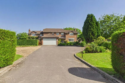
- Price
- £2,500,000
- Size
- 10 acres
Grange Road, Old Netley, Bursledon, SO31, Hound, Hampshire SO31 8BT England
Added on 04/07/2026House with Land
- Price
- Guide Price£2,350,000
- Size
- 8.4 acres
Added on 29/01/2026House with Land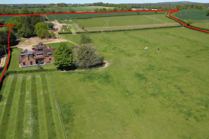
- Price
- Guide Price£3,050,000
- Size
- 67.17 acres
Added on 13/06/2026Farm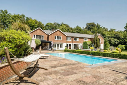
- Price
- £2,400,000
- Size
- 3 acres
Midlington Hill, Droxford, Southampton, Hampshire, SO32, Droxford, Hampshire SO32 3PU England
Added on 04/07/2026Country Home
- Price
- £2,900,000
- Size
- 9 acres
Allington Lane, Fair Oak, SO50, West End, Hampshire SO50 7DE England
Added on 17/06/2026House with Land
- Price
- Guide Price£3,050,000
- Size
- 17.83 acres
Furzeley Road, Waterlooville, Hampshire, PO7, Denmead, Hampshire PO7 6TX England
Added on 18/06/2026House with Land
- Price
- £2,250,000
- Size
- 5.04 acres
Twiggs Lane, Marchwood, Hampshire, Marchwood, Hampshire SO40 4UN England
Added on 28/01/2026Estate
- Price
- Guide Price£2,250,000
- Size
- 3.25 acres
Puckpool, Isle of Wight, Nettlestone and Seaview, Isle of Wight PO33 1PJ England
Added on 18/06/2026House with Land