Lower Dunsforth, York, North Yorkshire, YO26
- Land size
- 63.89 acres
Description
Location
The land at Scarers Lane is situated approximately 0.5 mile to the south-east of the village of Lower Dunsforth which itself is situated approximately 4 miles to the south-east of the market town of Boroughbridge and 16 miles to the north-west of the city of York. Access to the A1(M) is within 4 miles which connects the service centres of the north-east.
Land
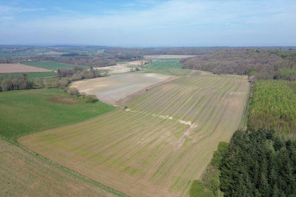
The property comprises a ring-fenced parcel of productive meadow and pasture land with frontage to the River Ure and extending in all to approximately 63.89 acres which comprises approximately 22.69 acres of improved grassland and 41.20 acres of pasture land.
The land is all classified as being Grade 3 under the former MAFF Land Classification Series.
The underlying soil type is classed as being part of the Foggathorpe series which is described as a slowly permeable, loamy and fine loamy over clayey soil and summarised as being suited to cereal cropping, dairying and stock rearing.
The land is generally level being situated approximately 20 metres above sea level. The boundaries predominantly comprise mature hedgerow interspersed with timber post and wire fencing forming livestock proof boundaries.
The land is accessed directly from the adopted highway known as Scarers Lane with a public footpath transecting the land connecting Scarers Lane with the banks of the River Ure where the footpath continues north.
Method of sale
The property is offered for sale by private treaty as a whole. The vendors reserve the right to conclude the sale by any other means at their discretion.
If you have downloaded these particulars, please register your interest with the selling agent.
Tenure & Possession
The freehold of the Property is offered for sale subject to a Farm Business Tenancy (FBT) which is due to expire on 9th September 2026.
Services
The land is not connected to any mains services.
Wayleaves Easements & Rights of Way
The land is sold subject to and with the benefits of all rights of way, water drainage, water courses and other easements and rights of adjoining owners (if any) affecting the same and all existing and proposed wayleaves and other matters registered by any competent authority subject to statute.
Health & Safety
Parties are reminded to be as vigilant as possible when making an inspection and be aware of potential hazards including open ditches and drains. Parties viewing the property do so, entirely at their own risk.
VAT
Any prices quoted are exclusive of VAT. In the event that the sale of the property or any part of it or any right attached to it becomes a chargeable supply for the purposes of VAT, such tax will be payable in addition to the purchase price.
Sporting, Fishing, Timber & Mineral Rights
The sporting, fishing, timber and mineral rights are included in so far as they are owned.
Local Authorities
North Yorkshire Council
Viewings
Parties are permitted to view the land on foot and during reasonable daylight hours.
Directions
From Boroughbridge, travel south on the B6265. After approx. 2.5 miles turn left onto Hunday Field Road signposted Lower Dunsforth. Continue through the village of Lower Dunsforth following Beck Closes Road for approx. 0.3 mile before turning left onto the no-through road signposted Dunsforth Lodge. The land is situated after approximately 0.4 mile marked with a Carter Jonas For Sale board.
What3Words
///keyboard.nicknames.pets
Map Location
Property details
- Tenure
- Freehold
- Council Tax Band
- TBC
- Date Posted
- 2026-01-29
Market Value Analysis
Compared with 26 Farmland & Pasture listings in Yorkshire and The Humber (50+ acres).
Utilities & Restrictions
Utilities
- Electricity
- Ask Agent
- Water
- Ask Agent
- Heating
- Ask Agent
- Broadband
- Ask Agent
- Sewerage
- Ask Agent
Rights & Restrictions
- Public Rights of Way
- Ask Agent
- Private Rights of Way
- Ask Agent
- Listed Property
- Ask Agent
- Restrictions
- Ask Agent
Property Features
- Accessibility
- Ask Agent
- Parking
- Ask Agent
- Garden
- Ask Agent
Important notice: Information, maps and tags on this page are supplied by the advertising agent or generated automatically. LandSale has not verified them. Relying on these details is at your own risk, always carry out independent checks before committing to a purchase.
LandSale full disclaimer
Marketing information only - not formal particulars. The details on this website are provided for general guidance and do not constitute an offer or contract. Neither LandSale nor the advertising estate/land agent accepts responsibility for any inaccuracy.
1. Source of information
- Agent-supplied content: Core description, asking price, tenure, measurements, photographs and planning history are uploaded by the appointed agent, who remains solely responsible for their accuracy.
- Automated tags & categorisation: Property type, land-use class, acreage bands and similar labels may be applied by machine-learning models. They are intended as a helpful guide only and may not reflect the property's legal status or permitted use.
- Third-party & enriched data layers: Maps, boundary outlines, planning designations, soil reports, broadband coverage and other environmental or location-based insights are licensed from external suppliers. Such data are supplied “as is", may be incomplete or out of date and are subject to change without notice.
2. Verification required
Prospective purchasers must verify critical matters, including but not limited to planning permission, title boundaries, public rights of way, environmental constraints, acreage, services, access and VAT status, through their own inspections, specialist surveys, legal advisers and the selling agent before relying on the information or entering into any contract.
3. No warranty or liability
LandSale gives no warranty, express or implied, as to the accuracy, completeness or fitness for any particular purpose of the information displayed. LandSale shall not be liable for any loss, damage, cost or expense arising directly or indirectly from any use of or reliance on such information, save where liability may not be excluded by law.
4. Updates & feedback
If you believe any detail on this listing is inaccurate, please let us know. We will investigate and, where appropriate, update the listing or notify the agent.
© LandSale | Version 1.2 - January 2026
Listing agent
Carter Jonas Rural, Yorkshire
82 Micklegate, York, YO1 6LF
Similar properties for sale
- Price
- Guide Price£325,000
- Size
- 32.5 acres
Ganthorpe, York, Terrington, North Yorkshire YO60 6QD England
Added on 29/01/2026Arable Land
- Price
- Guide Price£520,000
- Size
- 47.22 acres
Checker Lane, Riccall, Selby, Riccall, North Yorkshire YO19 6FS England
Added on 04/06/2026Arable Land
- Price
- Guide Price£525,000
- Size
- 58.6 acres
58.60 acres of Land at Amotherby, Malton, Amotherby, North Yorkshire YO17 6UN England
Added on 06/06/2026Agricultural Land
- Price
- Guide Price£485,000
- Size
- 111.38 acres
Lot 2 - Land at Ramsgill, Harrogate, Stonebeck Down, North Yorkshire HG3 5RT England
Added on 29/01/2026Farmland
- Price
- Guide Price£380,000
- Size
- 109.24 acres
Lot 3 - Land at Ramsgill, Harrogate, Stonebeck Down, North Yorkshire HG3 5RT England
Added on 29/01/2026Farmland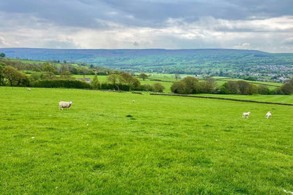
- Price
- Guide Price£400,000
- Size
- 33.5 acres
Added on 01/07/2026Farm
- Price
- £375,000
- Size
- 52.64 acres
Balne Moor Road, Balne, Goole, North Yorkshire, DN14, Balne, North Yorkshire DN14 0EN England
Added on 29/01/2026Agricultural Land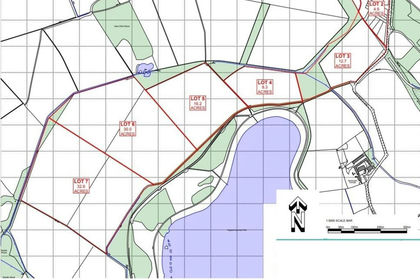
- Price
- Offers Over£450,000
- Size
- 32.6 acres
Added on 22/02/2026Farmland
- Price
- Guide Price£525,000
- Size
- 69.39 acres
Land at Hollins Hill, Charltons, Guisborough, Lockwood, Redcar and Cleveland TS12 3DE England
Added on 29/01/2026Arable Land