Hollacombe, Crediton, EX17
- Bedrooms
- 4
- Bathrooms
- 3
Key Features
- Semi-detached barn conversion
- 4 bedrooms and 3 bathrooms
- Just a short distance from Crediton
- Gorgeous south facing gardens
- Light, open living spaces
- Additional utility and hobby room/study
- Kitchen/dining room with island
- Parking
- Gas central heating
- EPC: D
Description
Set right in the middle of Devon’s rolling hills is the little known hamlet of Hollacombe, just a couple of miles outside of Crediton, this beautiful and unspoilt area is a real hidden gem. The villages of Coleford, Yeoford and Copplestone are only a stone’s throw too, the latter two with train stations, so although it’s quiet, it’s not isolated, just a perfect retreat from busy life. Leaving Crediton via Cromwells Cutting is an experience in itself and one that never seems to get old, and soon, turning off down a private lane, you’ll find yourself in this tranquil semi-rural setting.
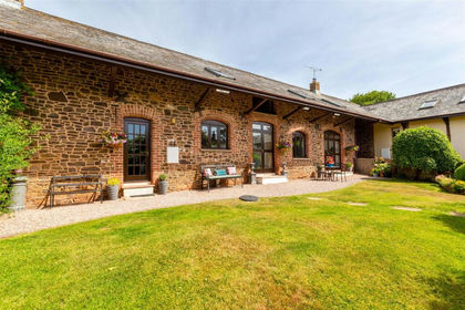
The property was converted in 2009 by local developers Drew and Sons and it’s since undergone further upgrades and improvements. It’s a comfortable home with gas central heating (LPG) and double glazing, quality fittings and a flexible layout with three bedrooms on the first floor (master ensuite) and then a fourth bedroom and w/c with integrated bidet on the ground floor. We love the options that are open to how this home is used! At the rear is a dedicated study/hobby room with side access and there’s a good sized utility room too, perfect for keeping the white goods out of sight! But it’s at the front that this barn really connects with it’s rural environment. The open plan living room opens onto the south facing gardens, flooding it with light, yet cosy in the winter. An opening leads through to the stylish, modern kitchen with its island and solid surfaces creates an excellent flow between the two but with distinct zones.
Outside, the private lane in from the country lane leads to just 4 properties. The garden to No.2 lies to the south so gets plenty of sunlight. There’s off-road parking for two vehicles (plus a small car or trailer behind the house) and the front garden is level and well stocked. There’s gorgeous seating areas with a vine covered pergola adding shade and character. There’s lawn too and the whole garden is a delightful place to sit. There’s access via the side to get to the rear of the property where there’s storage, the additional parking and of course access for maintenance.
A surprisingly spacious barn conversion with a south facing garden, in a wonderful semi-rural location just minutes from town!
Buyers' Compliance Fee Notice
Please note that a compliance check fee of £25 (inc. VAT) per person is payable once your offer is accepted. This non-refundable fee covers essential ID verification and anti-money laundering checks, as required by law.
Please see the floorplan for room sizes.
Current Council Tax: Band D – Mid Devon
Approx Age: Converted 2009
Construction Notes: Cob and block under slate roof
Utilities: Mains electric, water, telephone & broadband
Drainage: Private Drainage (treatment plant)
Heating: LPG Gas fired central heating
Listed: No
Conservation Area: No
Tenure: Freehold
CREDITON is a vibrant market town with a bustling high street full of independent shops, eateries, and pubs. In recent years a diverse arts scene has grown to include all manner of mediums, with the performing arts making use of the town’s market square where, in the summer months, a range of activities take place. The market square is also home to the town’s twice-monthly farmer’s market. The town has an equally significant past. It was originally the first Bishopric in Devon and the imposing Parish Church of The Holy Cross now stands where once stood Devon’s first Saxon cathedral (909-1050AD). It is also the birthplace of Saint Boniface, one of the founding fathers of the Christian church in Europe. Easily commutable to Exeter and with two primary schools, a secondary school with sixth form as well as a wide range of necessary amenities, it’s clear why the town is a firm favourite with locals and relocators alike.
DIRECTIONS
For sat-nav use EX17 5BW and the What3Words address is ///submit.dining.cubed but if you want the traditional directions, please read on.
From Crediton High Street, continue towards Copplestone along the A377. Pass Homeleigh Garden Centre on your right and take the next left at Barnstaple Cross, continue along to the next crossroads (Raddon Down Cross) and turn left towards the recycling centre, now continue for approx. 0.6 miles and take the next left signposted to Hollacombe Hamlets and look out for a concrete track on your left, it’s signed The Barns. Continue down the track and you’ll arrive at The Barns with No 2 being the nearest of the semi-detached barns.
EPC Rating: D
Map Location
Property details
- Tenure
- Freehold
- Council Tax Band
- Ask Agent
- Date Posted
- 2026-01-29
Energy Performance Certificate
Energy Efficiency Rating
Based on UK Energy Performance Certificate standards (EU Directive 2002/91/EC)
Running costs are one side. Planning activity, flood history and ground risks for this location are in the full report.
Utilities & Restrictions
Utilities
- Electricity
- Ask Agent
- Water
- Ask Agent
- Heating
- Gas Central Heating
- Broadband
- Ask Agent
- Sewerage
- Ask Agent
Rights & Restrictions
- Public Rights of Way
- Ask Agent
- Private Rights of Way
- Ask Agent
- Listed Property
- Ask Agent
- Restrictions
- Ask Agent
Listed status, conservation areas and planning constraints for this location are in the full report.
Property Features
- Accessibility
- Ask Agent
- Parking
- Parking Available
- Garden
- Private Garden
Beyond the particulars: planning activity, flood history, heritage and ground risks, checked for this exact spot.
Connectivity
Broadband
Fastest speed available at this postcode
1.8 Gbps
Gigabit full fibre · available to 20% of premises
Suitable for
- 4K streaming on every screen
- Full-time home working
- Online gaming & big downloads
Fixed wireless access may also be an option here.
Mobile signal
Outdoor predictions; indoor signal depends on building materials.
Ofcom Connected Nations postcode-level predictions. Speeds and signal are modelled, not measured, and vary between addresses and providers.
Signal is the easy part. Planning activity, flood history and protected designations here are in the full report.
Nearest Schools
Primary
- Yeoford Community Primary School1.5 milesNo Ofsted rating
- Ages
- 4 to 11
- Pupils
- 56
- Type
- Academy converter
- Landscore Primary School1.6 milesOfsted: Good
- Ages
- 4 to 11
- Pupils
- 276
- Type
- Community school
- Copplestone Primary School2.1 milesOfsted: Good
- Ages
- 4 to 11
- Pupils
- 138
- Type
- Foundation school
- Sandford School2.5 milesOfsted: Good
- Ages
- 3 to 11
- Pupils
- 74
- Type
- Community school
- Hayward's Primary School2.6 milesOfsted report card · Mar 2026
- Ages
- 4 to 11
- Pupils
- 403
- Type
- Community school
Secondary
- Queen Elizabeth's1.9 milesOfsted report card · May 2026
- Ages
- 11 to 18
- Pupils
- 1,096
- Type
- Academy converter
- Thomas Hall School7.9 milesOfsted: Requires improvement
- Ages
- 4 to 16
- Pupils
- 438
- Type
- Free schools
- West Exe School9.4 milesOfsted report card · Jun 2026
- Ages
- 11 to 16
- Pupils
- 1,237
- Type
- Academy sponsor led
- St James School10 milesNo Ofsted rating
- Ages
- 11 to 16
- Pupils
- 985
- Type
- Academy converter
- Isca Academy10 milesNo Ofsted rating
- Ages
- 11 to 16
- Pupils
- 860
- Type
- Academy sponsor led
Distances are straight-line from the advertised location. Source: the national school registers (DfE, Welsh Government, Scottish Government) and Ofsted.
Schools are just the start: sold prices nearby, planning activity and any flood history are in the full report.
Amenities
Supermarket
GP surgery
Pharmacy
Hospital
Straight-line distances from the advertised location. Sources: NHS records, Geolytix supermarket locations, OS Open Greenspace and the national trails registers.
The area stacks up? Now check the location itself: planning nearby, protected designations and past flooding.
Getting Around
Nearest station
Nearest bus stop
Typical drive times
Straight-line distances from the advertised location; drive times are typical free-flow times over OpenStreetMap road data, so allow more at peak. Public transport locations from DfT NaPTAN.
Easy to reach matters. So do planning activity, flood history and ground risks: all in the full report.
Flood Risk
From Environment Agency flood map open data, checked around the advertised map pin and allowing for the listed acreage where known. This summary comes from LandSale, the advertising platform, not from the listing agent, and is not part of the agent's particulars. Risk can vary across a single holding, so verify anything critical through your own searches before committing.
Rivers and the sea
Surface water
The detail behind these bandings
The full report pinpoints where this location sits on the flood maps, and runs the deeper checks that usually only surface after an offer.
- Exact flood zones & annual chances (included in the full report)
- Any recorded past flooding (included in the full report)
- Planning activity nearby (included in the full report)
- Heritage & conservation (included in the full report)
- Protected nature designations (included in the full report)
- Ground risks (included in the full report)
- Sold prices nearby (included in the full report)
£14.99 · one-off purchase
By LandSale, the platform. Not provided by the listing agent. Ready in about a minute.
Important notice: Information, maps and tags on this page are drawn from the advertising agent's marketing materials or generated automatically. LandSale has not verified them. Relying on these details is at your own risk, always carry out independent checks before committing to a purchase.
LandSale full disclaimer
Marketing information only - not formal particulars. The details on this website are provided for general guidance and do not constitute an offer or contract. Neither LandSale nor the advertising estate/land agent accepts responsibility for any inaccuracy.
1. Source of information
- Listing content: Core description, asking price, tenure, measurements, photographs and planning history originate from the marketing materials of the advertising estate or land agent. LandSale does not author this content and cannot guarantee its accuracy.
- Automated tags & categorisation: Property type, land-use class, acreage bands and similar labels may be applied by machine-learning models. They are intended as a helpful guide only and may not reflect the property's legal status or permitted use.
- Third-party & enriched data layers: Maps, boundary outlines, planning designations, soil reports, broadband coverage and other environmental or location-based insights are licensed from external suppliers. Such data are supplied “as is", may be incomplete or out of date and are subject to change without notice.
2. Verification required
Prospective purchasers must verify critical matters, including but not limited to planning permission, title boundaries, public rights of way, environmental constraints, acreage, services, access and VAT status, through their own inspections, specialist surveys, legal advisers and the selling agent before relying on the information or entering into any contract.
3. No warranty or liability
LandSale gives no warranty, express or implied, as to the accuracy, completeness or fitness for any particular purpose of the information displayed. LandSale shall not be liable for any loss, damage, cost or expense arising directly or indirectly from any use of or reliance on such information, save where liability may not be excluded by law.
4. Updates & feedback
If you believe any detail on this listing is inaccurate, please let us know. We will investigate and, where appropriate, update the listing or notify the agent.
© LandSale | Version 1.3 - August 2026
Listing agent
Helmores, Crediton
111-112 High Street, Crediton, Devon, EX17 3LF
Similar properties for sale
- Price
- Guide Price£480,000
Added on 29/01/2026Barn Conversion
- Price
- Guide Price£425,000
- Size
- 1.93 acres
Upton Hellions, Crediton, EX17, Upton Hellions, Devon EX17 England
Added on 08/08/2026House with Land
- Price
- Offers in Region of£400,000
- Size
- 11 acres
Added on 24/06/2026Smallholding
- Price
- Guide Price£295,000
- Size
- 33.03 acres
Added on 03/07/2026Farm
- Price
- Guide Price£360,000
34.68 Acres - Bow, Crediton, Devon, EX17, Bow, Devon EX17 England
Added on 05/06/2026Farm
- Price
- £450,000
- Size
- 1.1 acres
Added on 01/04/2026Development Land
- Price
- Guide Price£315,000
- Size
- 0.39 acres
Added on 13/08/2026Building Plot
- Price
- £400,000
Added on 29/07/2026Building Plot
- Price
- Guide Price£350,000
Development Site, Toronto Road, Exeter, Exeter, Devon EX4 England
Added on 29/01/2026Development Land
- Price
- Guide Price£400,000
Added on 01/06/2026Barn Conversion