Trebarwith PL33
- Bedrooms
- 3
- Bathrooms
- 2
Key Features
- Superb Views
- Ample Parking
- Very Spacious Garden
- Oil Fired Central Heating
- Double Glazed Windows and External Doors
- Master Bedroom with En Suite Bathroom
- Fantastic Reversed Accommodation Design
- Feature Open Plan Living/Dining/Kitchen with Fully Fitted Kitchen with Built-in Appliances, Vaulted Ceiling and Exposed Timber Beams
- Amazing Location Close to Tregardock & Trebarwith
- Good Size Garden with Potential (see later note)
Description
A beautifully presented 3 bedroom, 2 bathroom barn conversion in a most wonderful location enjoying spectacular countryside and sea views. Freehold. Council Tax Band D. EPC rating C.
Trerubies is a beautiful reversed accommodation 3 bedroom barn conversion situated in this cluster of properties around the original farmhouse. The property enjoys a most wonderful location surrounded by countryside with lovely views over the fields and being so close to some of the most dramatic coastline and walks. Trebarwith Strand is a 1.1 mile walk from the property, renowned for its amazing sunsets and beautiful scenery.
We understand there was former consent in the top corner of the large garden for a garden building from which there would have been the most stunning views towards the coastline. This has now lapsed but the former planning application no. was PA/09247 if any interested parties would like to look at the historic details on the Cornwall Council online planning portal.
The Accommodation comprises with all measurements being approximate:
From the parking area, an external stairwell leads to
Fully Glazed Entrance Door to
Superb Open Plan Kitchen/Dining/Living Room - 9.25m x 3.82m
A lovely room with exposed timber beams and vaulted ceiling, triple aspect windows together with 3 double glazed Velux skylights, inset ceiling spotlights, lovely views over countryside and out to sea, 2 radiators, fully fitted modern kitchen comprising one and a half bowl single drainer stainless steel sink, mixer tap over, good range of built-in base and wall units, fitted worktops with matching splashbacks, built-in Neff stainless steel oven and grill, Neff ceramic hob, extractor fan and glazed splashback, integral Neff dishwasher, integral fridge and freezer. Feature staircase with oak/stainless steel and glazed balustrade with stairs leading down to the
Ground Floor
Hallway
With cupboard housing circuit breakers with electric light, space and plumbing for washing machine.
Shower Room
With large walk-in fully tiled shower enclosure with thermostatic shower, glazed screen, concealed cistern Geberit W.C., wash hand basin with pull out storage drawer below, fully tiled walls, underfloor heating, heated towel rail, slate window sill, extractor fan.
Bedroom 3 - 2.39m 3.5m
Radiator, window shelf.
Lobby
Having built-in shelved storage cupboards to side and 3 steps to
Bedroom 2 - 4.33m x 2.62m
With built-in cupboard, double glazed door to rear with sea views and window to rear, radiator, built-in desk to recess.
Master Bedroom Suite -
Built-in cupboards and
En Suite Bathroom
White suite comprising panelled bath with shower attachment, fully tiled surround, low level W.C., wash hand basin, cupboards below with attractive mirror, slate window sill, heated towel rail and underfloor heating.
5 steps lead down to the
Bedroom Area - 2.39m x 6m
Exposed painted timber beam, dual aspect windows and fully glazed French door leading on to the patio area, radiator.
Outside
A drive serves the cluster of properties. As you enter, turn to the right just before the property which leads to the parking area located on the left hand side behind the property. Gate leads to lower paved patio area. Attractive steps and glazed/stainless steel balustrading lead to the first floor entrance which has an attractive timber decking patio area taking advantage of the views and as can be seen on the photo and the video tour, then sweeps around to the lovely large gardens with stone walling and laid to lawn with top patio from where there are most wonderful views over the countryside and out to sea. Garden shed. Oil storage tank.
Services
Mains water and electricity are connected to the property. Drainage is to a septic tank.
Agents Note
Please note that an AML fee is chargeable to the buyer once an offer is accepted to cover the cost of carrying out the required identity and anti-money laundering checks. The fee is £30 plus VAT (£36 inc VAT) per person. Once these checks have been completed, the fee cannot be refunded, even if the property purchase does not go ahead.
PROOF OF FINANCE – Purchasers, before an offer is formally agreed, we will require proof of your financial ability to purchase. Again, we ask for your cooperation on this matter to avoid any unnecessary delays in issuing a memorandum of sale.
What3words: ///weekend.guru.samplers
Please contact our Wadebridge Office for further details
Map Location
Property details
- Tenure
- Freehold
- Council Tax Band
- D
- Date Posted
- 2026-01-29
Price history
| Date | Change | Price |
|---|---|---|
| 25 Sep 2026 | Reduced 4.3% (−£25,000) | £550,000 |
| Until 25 Sep 2026 | Asking price | £575,000 |
Energy Performance Certificate
Energy Efficiency Rating
Based on UK Energy Performance Certificate standards (EU Directive 2002/91/EC)
Running costs are one side. Planning activity, flood history and ground risks for this location are in the full report.
Utilities & Restrictions
Utilities
- Electricity
- Ask Agent
- Water
- Ask Agent
- Heating
- Ask Agent
- Broadband
- Ask Agent
- Sewerage
- Ask Agent
Rights & Restrictions
- Public Rights of Way
- Ask Agent
- Private Rights of Way
- Ask Agent
- Listed Property
- Ask Agent
- Restrictions
- Ask Agent
Listed status, conservation areas and planning constraints for this location are in the full report.
Property Features
- Accessibility
- Ask Agent
- Parking
- Driveway
- Garden
- Garden
Beyond the particulars: planning activity, flood history, heritage and ground risks, checked for this exact spot.
Connectivity
Broadband
Fastest speed available at this postcode
21 Mbps
Standard (10-30 Mbps)
Suitable for
- Web & social
- Music streaming
- Standard video calls
Mobile signal
Predicted 4G and 5G signal; indoor signal depends on building materials.
Ofcom Connected Nations postcode-level predictions. Speeds and signal are modelled, not measured, and vary between addresses and providers.
Signal is the easy part. Planning activity, flood history and protected designations here are in the full report.
Nearest Schools
Primary
- Delabole Primary School1.1 milesNo Ofsted rating
- Ages
- 4 to 11
- Pupils
- 70
- Type
- Academy sponsor led
- Tintagel Primary School1.5 milesNo Ofsted rating
- Ages
- 2 to 11
- Pupils
- 89
- Type
- Academy converter
- Camelford Community Primary School2.9 milesOfsted: Good
- Ages
- 2 to 11
- Pupils
- 253
- Type
- Academy converter
- St Teath Community Primary School2.9 milesOfsted: Good *
- Ages
- 2 to 11
- Pupils
- 145
- Type
- Academy converter
- Boscastle Community Primary School4.2 milesNo Ofsted rating
- Ages
- 4 to 11
- Pupils
- 60
- Type
- Foundation school
Secondary
- Sir James Smith's School2.9 milesNo Ofsted rating
- Ages
- 11 to 16
- Pupils
- 588
- Type
- Academy converter
- Wadebridge School8.7 milesOfsted: Good
- Ages
- 11 to 16
- Pupils
- 1,018
- Type
- Academy converter
- Bodmin College12 milesOfsted: Requires improvement *
- Ages
- 11 to 18
- Pupils
- 1,236
- Type
- Academy converter
- Budehaven Community School16 milesOfsted: Good
- Ages
- 11 to 18
- Pupils
- 1,145
- Type
- Foundation school
- Launceston College17 milesOfsted: Good
- Ages
- 11 to 18
- Pupils
- 1,205
- Type
- Academy converter
* Latest graded judgement covers quality of education only; no overall grade was issued under the 2024-25 inspection framework.
Distances are straight-line from the advertised location. Source: the national school registers (DfE, Welsh Government, Scottish Government) and Ofsted.
Schools are just the start: sold prices nearby, planning activity and any flood history are in the full report.
Amenities
Supermarket
GP surgery
Pharmacy
Hospital
Walking trail
Straight-line distances from the advertised location. Sources: NHS records, Geolytix supermarket locations, OS Open Greenspace and the national trails registers.
The area stacks up? Now check the location itself: planning nearby, protected designations and past flooding.
Getting Around
Nearest station
Nearest bus stop
Typical drive times
Straight-line distances from the advertised location; drive times are typical free-flow times over OpenStreetMap road data, so allow more at peak. Public transport locations from DfT NaPTAN.
Easy to reach matters. So do planning activity, flood history and ground risks: all in the full report.
Flood Risk
Environment Agency open data, checked around the advertised map pin for the listed acreage. Long-term risk counts flood defences; the planning map's flood zones do not. Provided by LandSale, not the listing agent, and not part of the agent's particulars. Risk varies across a holding, so verify before committing.
Rivers and the sea
Planning map: Flood Zone 1.
Surface water
These bandings are the summary. Where this location sits on the flood maps, plus planning activity, heritage and ground risks, is in the full report.
Important notice: Information, maps and tags on this page are drawn from the advertising agent's marketing materials or generated automatically. LandSale has not verified them. Relying on these details is at your own risk, always carry out independent checks before committing to a purchase.
LandSale full disclaimer
Marketing information only - not formal particulars. The details on this website are provided for general guidance and do not constitute an offer or contract. Neither LandSale nor the advertising estate/land agent accepts responsibility for any inaccuracy.
1. Source of information
- Listing content: Core description, asking price, tenure, measurements, photographs and planning history originate from the marketing materials of the advertising estate or land agent. LandSale does not author this content and cannot guarantee its accuracy.
- Automated tags & categorisation: Property type, land-use class, acreage bands and similar labels may be applied by machine-learning models. They are intended as a helpful guide only and may not reflect the property's legal status or permitted use.
- Third-party & enriched data layers: Maps, boundary outlines, planning designations, soil reports, broadband coverage and other environmental or location-based insights are licensed from external suppliers. Such data are supplied “as is", may be incomplete or out of date and are subject to change without notice.
2. Verification required
Prospective purchasers must verify critical matters, including but not limited to planning permission, title boundaries, public rights of way, environmental constraints, acreage, services, access and VAT status, through their own inspections, specialist surveys, legal advisers and the selling agent before relying on the information or entering into any contract.
3. No warranty or liability
LandSale gives no warranty, express or implied, as to the accuracy, completeness or fitness for any particular purpose of the information displayed. LandSale shall not be liable for any loss, damage, cost or expense arising directly or indirectly from any use of or reliance on such information, save where liability may not be excluded by law.
4. Updates & feedback
If you believe any detail on this listing is inaccurate, please let us know. We will investigate and, where appropriate, update the listing or notify the agent.
© LandSale | Version 1.3 - August 2026
Listing agent
Cole Rayment & White, Wadebridge
20 Molesworth Street, Wadebridge, PL27 7DG
Contact Cole Rayment & White, Wadebridge
20 Molesworth Street, Wadebridge, PL27 7DG
View agent profileSimilar properties for sale
- Price
- £625,000
- Size
- 4.58 acres
Added on 07/10/2026House with Land
- Price
- Guide Price£565,000
Added on 10/07/2026Barn Conversion
- Price
- Offers in Excess of£420,000
Added on 03/07/2026Barn Conversion
- Price
- £600,000
- Size
- 2.59 acres
St. Gennys, Bude, Cornwall, St. Gennys, Cornwall EX23 England
Added on 19/05/2026Barn Conversion
- Price
- £525,000
- Size
- 4.5 acres
Millpool, Edge of Bodmin Moor, Cornwall, Cardinham, Cornwall PL30 England
Added on 13/06/2026House with Land
- Price
- Guide Price£650,000
- Size
- 7.5 acres
Burlawn, Wadebridge, Cornwall, PL27, St. Breock, Cornwall PL27 England
Added on 09/10/2026House with Land
- Price
- Guide Price£525,000
- Size
- 2.12 acres
Added on 28/08/2026House with Land Added on 29/01/2026Barn Conversion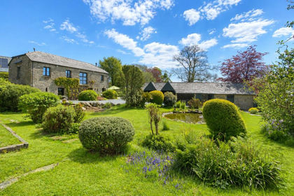
- Price
- £575,000
- Size
- 0.5 acres
Laneast, Launceston, Cornwall, PL15, Laneast, Cornwall PL15 England
Added on 31/03/2026Barn Conversion
- Price
- Guide Price£575,000
- Size
- 3.7 acres
Added on 23/05/2026Multiple Dwelling Property