Branton, Alnwick, Northumberland, NE66
- Bedrooms
- 3
- Bathrooms
- 1
Key Features
- Three bedrooms
- One bathroom
- One reception room
- Ground floor accommodation
- Communal gardens
- On site gym & spa facilities
Description
Charming three-bedroom stone cottage barn
conversion in a picturesque village setting. A successful holiday let, the property offers single-level living, a large communal garden, and access to a nearby swimming pool, sauna, gym tennis courts and golf simulator.
The Property
Old Mill Cottage is a charming three-bedroom barn conversion, thoughtfully arranged over a single level and set within a traditional courtyard setting. Benefitting from access to the excellent leisure facilities at Breamish Valley
Cottages, residents can enjoy use of the swimming pool, sauna, gym, tennis courts and golf simulator for an annual fee.
In recent years, the property has been
successfully operated as a holiday let, offering an
attractive lifestyle or investment opportunity.
Beautifully presented throughout, the cottage offers warm and welcoming accommodation. The well-appointed kitchen features a range of stylish wall and base units, an electric oven and hob, washing machine, dishwasher and fridge freezer. Beyond, the bright and spacious sitting room enjoys a charming exposed stone feature wall and
dual-aspect windows overlooking both the courtyard and communal gardens.
There are three well-proportioned bedrooms, two of which benefit from pleasant garden views. Completing the accommodation is a contemporary bathroom comprising a bath with overhead shower, pedestal wash hand basin and WC.
Externally, residents can enjoy a large communal garden, providing the perfect space to relax and appreciate the peaceful village surroundings.
Notes
A service charge is payable towards the maintenance of the common areas but this also provides access to the leisure facilities at Breamish Valley Cottages which includes swimming pool, gym, tennis courts, sauna and steam room.
Tenure and Possession
Leasehold 999 years from 1st January 2007, 981 years remaining.
EPC Rating
This property has been certified with an EPC Rating of D/61.
Local Authority
Northumberland County Council. The property does not have a council tax banding as utilised as a holiday let.
Utilities
The property benefits from mains electricity, oil central heating and water and private drainage. The boiler and heating system is shared between three properties with each property having a meter.
Parking
Parking is available in the courtyard.
Characteristics
Broadband is currently connected with average download speeds of approximately 36Xmbps and average upload speeds of 8.5mbps. Mobile coverage is available, interested parties are advised to perform their own due diligence in respect of availability.
what3words
Every three metre square of the world has been given a unique combination of three words.
///runners.polices.safety
Viewings
Viewings are strictly by prior appointment with GFW.
Important Notice
Every care has been taken with the preparation of these particulars, but they are for general guidance only and complete accuracy cannot be guaranteed. If there is any point, which is of particular importance professional verification should be sought. All dimensions/boundaries are approximate. The mention of fixtures, fittings &/or appliances does not imply they are in full efficient working order. Photographs are provided for general information and you may not republish, retransmit, redistribute or otherwise make the material available to any party or make the same available on any website. These particulars do not constitute a contract or part of a contract.
The Area
Branton is a picturesque and peaceful Northumberland hamlet, situated just a mile from the A697 and offering excellent access to both Alnwick and Morpeth for commuters.
Nestled at the foot of the Cheviot Hills, the village enjoys a stunning rural setting surrounded by some of the county's most beautiful countryside. A welcoming community, highly regarded first school and popular wine bar and restaurant add to the appeal, while everyday amenities can be found nearby in Powburn.
The historic market town of Alnwick is only a short drive away and offers a wider range of shopping, dining and leisure facilities. Renowned for its magnificent Castle and Gardens, Alnwick continues to be one of Northumberland's most sought-after destinations. The region's spectacular Heritage Coastline is also within
easy reach, providing miles of unspoilt beaches, dramatic scenery and charming coastal villages to explore.
Map Location
Property details
- Tenure
- Leasehold
- Council Tax Band
- TBC
- Date Posted
- 2026-01-29
Price history
| Date | Change | Price |
|---|---|---|
| 13 Oct 2026 | Reduced 3.8% (−£10,000) | £250,000 |
| Until 13 Oct 2026 | Asking price | £260,000 |
Energy Performance Certificate
Energy Efficiency Rating
Based on UK Energy Performance Certificate standards (EU Directive 2002/91/EC)
Running costs are one side. Planning activity, flood history and ground risks for this location are in the full report.
Leasehold Information
- Length of Lease
- 979 years remaining
Tenure is one layer. The full report checks the location itself: planning activity, flood history and heritage.
Utilities & Restrictions
Utilities
- Electricity
- Ask Agent
- Water
- Ask Agent
- Heating
- Ask Agent
- Broadband
- Ask Agent
- Sewerage
- Ask Agent
Rights & Restrictions
- Public Rights of Way
- Ask Agent
- Private Rights of Way
- Ask Agent
- Listed Property
- Ask Agent
- Restrictions
- Ask Agent
Listed status, conservation areas and planning constraints for this location are in the full report.
Property Features
- Accessibility
- Ask Agent
- Parking
- Parking Available
- Garden
- Ask Agent
Beyond the particulars: planning activity, flood history, heritage and ground risks, checked for this exact spot.
Connectivity
Broadband
Fastest speed available at this postcode
1.8 Gbps
Gigabit full fibre · available to 62% of premises
Suitable for
- 4K streaming on every screen
- Full-time home working
- Online gaming & big downloads
Mobile signal
Predicted 4G and 5G signal; indoor signal depends on building materials.
Ofcom Connected Nations postcode-level predictions. Speeds and signal are modelled, not measured, and vary between addresses and providers.
Signal is the easy part. Planning activity, flood history and protected designations here are in the full report.
Nearest Schools
Primary
- Branton Primary School and Nursery61 metresNo Ofsted rating
- Ages
- 2 to 11
- Pupils
- 39
- Type
- Academy converter
- Whittingham Church of England Primary School3 milesNo Ofsted rating
- Ages
- 2 to 11
- Pupils
- 81
- Type
- Voluntary controlled school
- Faith
- Church of England
- Wooler First School7.8 milesNo Ofsted rating
- Ages
- 2 to 11
- Pupils
- 107
- Type
- Community school
- Ncea Harry Hotspur Church of England Primary School8.7 milesOfsted: Good
- Ages
- 2 to 11
- Pupils
- 104
- Type
- Academy converter
- Faith
- Church of England
- Thropton Village First School8.7 milesNo Ofsted rating
- Ages
- 3 to 9
- Pupils
- 36
- Type
- Academy converter
Secondary
- Dr Thomlinson Church of England Middle School9.5 milesNo Ofsted rating
- Ages
- 9 to 13
- Pupils
- 184
- Type
- Academy converter
- Faith
- Church of England
- The Duchess's Community High School9.6 milesOfsted: Requires improvement
- Ages
- 11 to 18
- Pupils
- 1,276
- Type
- Academy converter
- James Calvert Spence College15 milesOfsted: Good
- Ages
- 11 to 19
- Pupils
- 567
- Type
- Community school
- The King Edward VI School21 milesOfsted: Good *
- Ages
- 13 to 18
- Pupils
- 1,426
- Type
- Academy converter
- Morpeth Chantry Middle School21 milesOfsted report card · Mar 2026
- Ages
- 9 to 13
- Pupils
- 525
- Type
- Academy converter
* Latest graded judgement covers quality of education only; no overall grade was issued under the 2024-25 inspection framework.
Distances are straight-line from the advertised location. Source: the national school registers (DfE, Welsh Government, Scottish Government) and Ofsted.
Schools are just the start: sold prices nearby, planning activity and any flood history are in the full report.
Amenities
Supermarket
GP surgery
Pharmacy
Hospital
Straight-line distances from the advertised location. Sources: NHS records, Geolytix supermarket locations, OS Open Greenspace and the national trails registers.
The area stacks up? Now check the location itself: planning nearby, protected designations and past flooding.
Getting Around
Nearest station
Nearest bus stop
Typical drive times
Straight-line distances from the advertised location; drive times are typical free-flow times over OpenStreetMap road data, so allow more at peak. Public transport locations from DfT NaPTAN.
Easy to reach matters. So do planning activity, flood history and ground risks: all in the full report.
Flood Risk
Environment Agency open data, checked around the advertised map pin for the listed acreage. Long-term risk counts flood defences; the planning map's flood zones do not. Provided by LandSale, not the listing agent, and not part of the agent's particulars. Risk varies across a holding, so verify before committing.
Rivers and the sea
Planning map: Flood Zone 1.
Surface water
Not at the pin: mapped about 10 metres away.
These bandings are the summary. Where this location sits on the flood maps, plus planning activity, heritage and ground risks, is in the full report.
Important notice: Information, maps and tags on this page are drawn from the advertising agent's marketing materials or generated automatically. LandSale has not verified them. Relying on these details is at your own risk, always carry out independent checks before committing to a purchase.
LandSale full disclaimer
Marketing information only - not formal particulars. The details on this website are provided for general guidance and do not constitute an offer or contract. Neither LandSale nor the advertising estate/land agent accepts responsibility for any inaccuracy.
1. Source of information
- Listing content: Core description, asking price, tenure, measurements, photographs and planning history originate from the marketing materials of the advertising estate or land agent. LandSale does not author this content and cannot guarantee its accuracy.
- Automated tags & categorisation: Property type, land-use class, acreage bands and similar labels may be applied by machine-learning models. They are intended as a helpful guide only and may not reflect the property's legal status or permitted use.
- Third-party & enriched data layers: Maps, boundary outlines, planning designations, soil reports, broadband coverage and other environmental or location-based insights are licensed from external suppliers. Such data are supplied “as is", may be incomplete or out of date and are subject to change without notice.
2. Verification required
Prospective purchasers must verify critical matters, including but not limited to planning permission, title boundaries, public rights of way, environmental constraints, acreage, services, access and VAT status, through their own inspections, specialist surveys, legal advisers and the selling agent before relying on the information or entering into any contract.
3. No warranty or liability
LandSale gives no warranty, express or implied, as to the accuracy, completeness or fitness for any particular purpose of the information displayed. LandSale shall not be liable for any loss, damage, cost or expense arising directly or indirectly from any use of or reliance on such information, save where liability may not be excluded by law.
4. Updates & feedback
If you believe any detail on this listing is inaccurate, please let us know. We will investigate and, where appropriate, update the listing or notify the agent.
© LandSale | Version 1.3 - August 2026
Listing agent
George F.White, Newcastle
Dean Street Arch 22 Dean Street Newcastle Upon Tyne NE1 1PG
Contact George F.White, Newcastle
Dean Street Arch 22 Dean Street Newcastle Upon Tyne NE1 1PG
View agent profileSimilar properties for sale
 Added on 24/06/2026Development Land
- Price
- Guide Price£280,000
Added on 29/01/2026Building Plot
- Price
- Guide Price£225,000
- Size
- 0.36 acres
Added on 14/05/2026Self Build Plot
- Price
- Offers Over£300,000
Added on 14/10/2026Building Plot
- Price
- £225,000
- Size
- 0.5 acres
Added on 29/01/2026Building Plot
- Price
- Offers in Excess of£300,000
Longhorsley, Morpeth, Northumberland, NE65, Longhorsley, Northumberland NE65 England
Added on 15/09/2026Development Land
- Price
- Offers in Excess of£300,000
- Size
- 3.22 acres
Added on 29/01/2026Cottage
- Price
- Offers Over£280,000
Added on 06/06/2026Development Land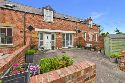
- Price
- Offers Over£210,000
The Courtyard, Backworth, Cramlington and Killingworth, North Tyneside NE27 England
Added on 05/07/2026Barn ConversionLeasehold
- Price
- Guide Price£295,000
- Size
- 0.31 acres
Former Miners Hall, Crawcrook, Tyne and Wear, NE40, Blaydon and Consett, Gateshead NE40 England
Added on 29/01/2026Redevelopment Land