Moat Farm Road, Folkestone, CT19
- Land size
- 2.25 acres
Key Features
- 2.25 Acres
- Planning for 30 units
- Y19/0704/FH
Description
Background:
The school site was originally sold as part of the enabling to fund the construction of the New Beacon school now in Moat Farm road which saw the merger of the Highview and Foxwood schools into new school facilities. The site is approximately 0.91 hectares in area (2.25 acres).
The site is the former home of the Highview school. The school was decanted after a new facility was built a short distance away. This new school, The Beacon now houses both the Highview and
Foxwood schools allowing for a new state of the art facility.
The site has good transport links to Folkestone, Ashford and Dover. The nearest train station is Folkestone central which is within 0.7 miles.
Further facilities in the proximity of the site:
- 2 Primary schools within 0.5 mile.
- Folkestone academy secondary School within 1 mile.
- A Tesco Extra within 0.5 miles and 0.7 miles from Sainsbury's supermarket.
- Within 0.6 miles of Radnor Park.
About Folkestone:
Folkestone is a conveniently located coastal Town that has train links via HS1 in under 1 hour to London St Pancras, the Channel Tunnel service to France and the port of Dover are within 10 miles
to the East. Folkestone has a number of regeneration projects with the development of Folkestone Seafront with over 700 apartments and the town of Otterpool as a new Garden Town in the next
25 years. and
It was announced on 18/01/2023, that Folkestone and Hythe District Council have been awarded £19.7 million for a major overhaul of Folkestone’s town centre to improve shopping areas, an
upgraded bus station and a new public green space to encourage businesses and visitors into the area.
The funding is for the three following projects:
1. Station Arrival and Town Centre Connections: This element of the project aims to improve the inks from the railway station for pedestrians and cyclists to encourage use of active travel and
public transport and to improve connections for visitors and residents alike.
2. Improved Gateway to the Town Centre and Bouverie Square: This component of the project will unlock transformational change around the town centre. The focus will be to reconfigure the main
bus station in the town centre and implement changes to the legacy gyratory road system to the north. The money will enable a sustainable, attractive and welcoming gateway to be created for Folkestone town centre with a green park replacing the bus station in Bouverie Square. The exciting and ambitious project will see Shellons Street become two-way with bus stops and bays replacing the bus station. Better signage and obvious walking links will connect visitors to a greener, more vibrant Sandgate Road and Guildhall Street shopping area.
3. Folca, Sandgate Road and Town Centre Public Realm: This element of the project will refurbish the Folca building (the former Debenhams building) into a ‘town lab’ which will encourage and
bring new and experimental uses into the town centre. The phased refurbishment of this building will bring a currently redundant building back into use in the town centre and reactivate this part of the high street. It will also improve the public realm on Sandgate Road to encourage footfall in this area of the town centre. The funding will also enable the second phase of Folca to be progressed by establishing new uses for the site, with an intended focus on public services, retail, leisure and business uses for the rejuvenated building.
There is a short video of the future of Folkestone here:
Planning Proposal: - Y19/0704/FH
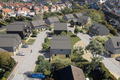
The proposed development has full planning permission for 24 houses and six flats with planning granted for 22% affordable dwellings.
The project is ready to commence construction with material planning start and pre-start conditions discharged.
The proposal is for a mixture of 1,2, 3 and 4 bed properties to consist of:
- 10 No 2 bed houses
- 12 No 3 bed houses
- 2 No 4 bed House (1 No Wheelchair compliant)
- 6 No 1 bed flats. (2 No Wheelchair compliant)
All of the proposals will include associated parking.
Landscaping:
The approach will be to produce a good variance of soft and hard landscaping as expected of that of a residential location. Consideration will be given to the variances in levels throughout the site to allow for an interesting and varied planning scheme. Careful deliberation has been given to allocate some space back to support the natural ecology, creating a low density development.
Appearance:
The proposed appearance will be in-keeping with the location whilst giving a modern appearance expected of the current period. With materials chosen to be informed by dwellings generally within
the area.
Stipulations:
Overage Clauses have been amended and will not trigger unless further units are added to a scheme and Rights of Way with KCC have been completed. Full details can be disclosed.
- CIL Contributions is calculated as £129,256 and S.106 contributions have been fixed at £14,791
Legal Costs: Each party to pay their own legal costs.
Viewings Strictly by appointment through Motis Estates Commercial Agents in Folkestone - or .
VACANT POSSESSION UPON COMPLETION SUBJECT TO CONTRACT (This firm operates a Complaints Handling Procedure, details of which are available upon request).
IMPORTANT NOTICE FROM MOTIS ESTATES Descriptions of the property are subjective and are used in good faith as an opinion and NOT as a statement of fact. Please make further specific enquires to ensure that our descriptions are likely to match any expectations you may have of the property. We have not tested any services, systems or appliances at this property. We strongly recommend that all the information we provide be verified by you on inspection, and by your Surveyor and Conveyancer.
Legal Costs: Each party to pay their own legal costs.
Viewings Strictly by appointment through Motis Estates Commercial Agents in Folkestone - or .
VACANT POSSESSION UPON COMPLETION SUBJECT TO CONTRACT (This firm operates a Complaints Handling Procedure, details of which are available upon request).
IMPORTANT NOTICE FROM MOTIS ESTATES Descriptions of the property are subjective and are used in good faith as an opinion and NOT as a statement of fact. Please make further specific enquires to ensure that our descriptions are likely to match any expectations you may have of the property. We have not tested any services, systems or appliances at this property. We strongly recommend that all the information we provide be verified by you on inspection, and by your Surveyor and Conveyancer.
Map Location
Property details
- Tenure
- Freehold
- Council Tax Band
- Ask Agent
- Date Posted
- 2026-01-28
Market Value Analysis
Compared with 109 Development Land listings in South East England (1+ acres).
Utilities & Restrictions
Utilities
- Electricity
- Ask Agent
- Water
- Ask Agent
- Heating
- Ask Agent
- Broadband
- Ask Agent
- Sewerage
- Ask Agent
Rights & Restrictions
- Public Rights of Way
- Ask Agent
- Private Rights of Way
- Ask Agent
- Listed Property
- Ask Agent
- Restrictions
- Ask Agent
Listed status, conservation areas and planning constraints for this location are in the full report.
Property Features
- Accessibility
- Ask Agent
- Parking
- Parking Available
- Garden
- Garden
Beyond the particulars: planning activity, flood history, heritage and ground risks, checked for this exact spot.
Connectivity
Broadband
Fastest speed available at this postcode
10 Gbps
Gigabit full fibre
Suitable for
- 4K streaming on every screen
- Full-time home working
- Online gaming & big downloads
Fixed wireless access may also be an option here.
Mobile signal
Outdoor predictions; indoor signal depends on building materials.
Ofcom Connected Nations postcode-level predictions. Speeds and signal are modelled, not measured, and vary between addresses and providers.
Signal is the easy part. Planning activity, flood history and protected designations here are in the full report.
Nearest Schools
Primary
- Mundella Primary School199 metresOfsted: Good
- Ages
- 3 to 11
- Pupils
- 184
- Type
- Academy converter
- Stella Maris Catholic Primary School388 metresNo Ofsted rating
- Ages
- 4 to 11
- Pupils
- 204
- Type
- Academy converter
- Faith
- Roman Catholic
- Castle Hill Community Primary School629 metresOfsted: Good
- Ages
- 3 to 11
- Pupils
- 395
- Type
- Community school
- Christ Church Cep Academy, Folkestone724 metresOfsted: Good
- Ages
- 4 to 11
- Pupils
- 411
- Type
- Academy converter
- Faith
- Church of England
- Folkestone Primary755 metresOfsted: Good
- Ages
- 2 to 11
- Pupils
- 460
- Type
- Academy sponsor led
Secondary
- Folkestone Academy755 metresOfsted report card · May 2026
- Ages
- 11 to 19
- Pupils
- 936
- Type
- Academy sponsor led
- The Harvey Grammar School0.9 milesNo Ofsted rating
- Ages
- 11 to 18
- Pupils
- 1,005
- Type
- Academy converter
- Gender
- Boys
- Turner Free School1.2 milesOfsted: Good
- Ages
- 11 to 18
- Pupils
- 997
- Type
- Free schools
- The Folkestone School for Girls1.4 milesOfsted: Good
- Ages
- 11 to 18
- Pupils
- 1,145
- Type
- Academy converter
- Gender
- Girls
- Brockhill Park Performing Arts College4.9 milesOfsted report card · Jan 2026
- Ages
- 11 to 18
- Pupils
- 1,314
- Type
- Academy converter
Distances are straight-line from the advertised location. Source: the national school registers (DfE, Welsh Government, Scottish Government) and Ofsted.
Schools are just the start: sold prices nearby, planning activity and any flood history are in the full report.
Amenities
Supermarket
GP surgery
Pharmacy
Hospital
Green space
Walking trail
Straight-line distances from the advertised location. Sources: NHS records, Geolytix supermarket locations, OS Open Greenspace and the national trails registers.
The area stacks up? Now check the location itself: planning nearby, protected designations and past flooding.
Getting Around
Nearest station
Nearest bus stop
Typical drive times
Straight-line distances from the advertised location; drive times are typical free-flow times over OpenStreetMap road data, so allow more at peak. Public transport locations from DfT NaPTAN.
Easy to reach matters. So do planning activity, flood history and ground risks: all in the full report.
Flood Risk
From Environment Agency flood map open data, checked around the advertised map pin and allowing for the listed acreage where known. This summary comes from LandSale, the advertising platform, not from the listing agent, and is not part of the agent's particulars. Risk can vary across a single holding, so verify anything critical through your own searches before committing.
Rivers and the sea
Surface water
The detail behind these bandings
The full report pinpoints where this location sits on the flood maps, and runs the deeper checks that usually only surface after an offer.
- Exact flood zones & annual chances (included in the full report)
- Any recorded past flooding (included in the full report)
- Planning activity nearby (included in the full report)
- Heritage & conservation (included in the full report)
- Protected nature designations (included in the full report)
- Ground risks (included in the full report)
- Sold prices nearby (included in the full report)
£14.99 · one-off purchase
By LandSale, the platform. Not provided by the listing agent. Ready in about a minute.
Important notice: Information, maps and tags on this page are drawn from the advertising agent's marketing materials or generated automatically. LandSale has not verified them. Relying on these details is at your own risk, always carry out independent checks before committing to a purchase.
LandSale full disclaimer
Marketing information only - not formal particulars. The details on this website are provided for general guidance and do not constitute an offer or contract. Neither LandSale nor the advertising estate/land agent accepts responsibility for any inaccuracy.
1. Source of information
- Listing content: Core description, asking price, tenure, measurements, photographs and planning history originate from the marketing materials of the advertising estate or land agent. LandSale does not author this content and cannot guarantee its accuracy.
- Automated tags & categorisation: Property type, land-use class, acreage bands and similar labels may be applied by machine-learning models. They are intended as a helpful guide only and may not reflect the property's legal status or permitted use.
- Third-party & enriched data layers: Maps, boundary outlines, planning designations, soil reports, broadband coverage and other environmental or location-based insights are licensed from external suppliers. Such data are supplied “as is", may be incomplete or out of date and are subject to change without notice.
2. Verification required
Prospective purchasers must verify critical matters, including but not limited to planning permission, title boundaries, public rights of way, environmental constraints, acreage, services, access and VAT status, through their own inspections, specialist surveys, legal advisers and the selling agent before relying on the information or entering into any contract.
3. No warranty or liability
LandSale gives no warranty, express or implied, as to the accuracy, completeness or fitness for any particular purpose of the information displayed. LandSale shall not be liable for any loss, damage, cost or expense arising directly or indirectly from any use of or reliance on such information, save where liability may not be excluded by law.
4. Updates & feedback
If you believe any detail on this listing is inaccurate, please let us know. We will investigate and, where appropriate, update the listing or notify the agent.
© LandSale | Version 1.3 - August 2026
Listing agent
Motis Estates, Folkestone
Suite 1-2 Motis Business Centre, Cheriton High Street, Folkestone, Kent, CT19 4QJ
Contact Motis Estates, Folkestone
Suite 1-2 Motis Business Centre, Cheriton High Street, Folkestone, Kent, CT19 4QJ
View agent profileSimilar properties for sale
- Price
- Offers in Region of£1,750,000
- Size
- 2.25 acres
Moat Farm Road, Folkestone, Kent, CT19, Folkestone, Kent CT19 England
Added on 29/01/2026Development Land
- Price
- Offers in Region of£1,950,000
- Size
- 3 acres
Shottendane Farm, Shottendane Road, Margate, Kent, CT9, East Thanet, Kent CT9 England
Added on 30/05/2026Development Land
- Price
- Offers in Region of£1,500,000
- Size
- 11 acres
Added on 05/04/2026Development Land
- Price
- Offers in Excess of£1,750,000
- Size
- 13 acres
Hillside Farm, Stockbury Valley, Stockbury, Sittingbourne, Kent, ME9, Stockbury, Kent ME9 England
Added on 10/06/2026Warehouse