Kings Wood Farm, Gillingham, Dorset, SP8
- Bedrooms
- 5
- Bathrooms
- 5
Key Features
- A superb opportunity to work with a reputable developer to build a new eco-home of c.300 sq. m. (3,230 sq. ft.)
- 5 double bedrooms, all with en suite bathrooms, large kitchen / dining / living room (10m x 8m), study and separate TV room
- Striking Dutch barn design with vaulted ceilings and open-plan living spaces. Generous private garden with far-reaching views.
- £950,000 build contract with JT Castle Developers
- Exceptional energy efficiency – solar park, air source heat pump & full underfloor heating
- Immense Stamp Duty Savings
- Exclusive development of 8 houses set in 10 acres
- Also available off-plan with choices of kitchen, bathrooms, flooring and landscaping (£1,450,000)
- 3-bedroom house available to rent free of charge during construction
- Just a short drive from Gillingham Station
Description
The Dutch Barn, Kings Wood Farm, Gillingham, Dorset, SP8 5QR
JT Castle are offering the opportunity for a buyer to work with them to construct this impressive 5-bedroom property. They are an extremely reputable developer with an exceptional portfolio of beautiful homes. The opportunity includes a purchase of the building plot at the advertised price, alongside a build contract of £950,000. Purchasing using this method results in immense Stamp Duty Savings compared to buying the finished property once it is constructed.
The Dutch Barn is a striking new home that blends traditional rural character with cutting-edge sustainable design. Set within Kings Wood Farm, an exclusive development of seven houses in 10 acres of beautiful countryside, this property offers generous private gardens, far-reaching views, and a truly exceptional lifestyle.
The house provides around 300 sq. m. of accommodation with a superb 10m x 8m open-plan kitchen, dining and living room, together with a study and TV room. There are five bedrooms, each with its own en suite.
Sustainability is at the core of the design, with every detail considered to reduce running costs and environmental impact. The home has a share in a 240 kW solar park, together with an air source heat pump, full underfloor heating, and high-performance construction using reclaimed and natural materials. A purchaser has full opportunity to select kitchens, bathrooms, finishes and landscaping to create a truly individual home.
Accommodation
The Dutch Barn has been designed to combine the character of a traditional rural building with the very best in modern, sustainable living. The distinctive gambrel roof and clean lines give the house a striking presence, while extensive glazing ensures the interiors are filled with light and connected to the landscape.
The accommodation extends to around 300 sq. m. and centres on a magnificent open-plan kitchen, dining and living room measuring 10m x 8m with a vaulted ceiling and sliding doors opening to the garden. A separate TV room and study provide further reception space and flexibility.
There are five generous bedrooms, each with its own en suite bathroom. The layout is adaptable, and partitions and sliding doors allow the spaces to be tailored for family living, entertaining, or working from home.
Kings Wood Farm is an exclusive development of seven houses, each with a generous private garden, set across 10 acres. The Dutch Barn has decking and outdoor living areas opening directly from the main living space, with uninterrupted views across open countryside.
A three-bedroom house on site is available to rent free of charge during the build period. This could alleviate any logistical difficulties and ensure a smooth purchasing process.
Services
The property has been built using a “fabric first” approach to ensure durability, energy efficiency, and comfort.
Solar power: The house has the benefit of a share in a private 240 kW solar park (approx. 35 kWp per house – far exceeding the average domestic system). This is designed to provide enough energy to power the home and electric vehicles at minimal cost.
Heating: An air source heat pump supplies 100% underfloor heating throughout, designed to run at low temperatures for optimum efficiency.
Construction: Cavity wall build with high levels of PIR insulation, concrete floors and high-performance glazing – providing excellent thermal mass, sound insulation and year-round comfort.
Materials: Sustainably sourced or reclaimed timbers, including Douglas Fir, Siberian Larch and oak, are used throughout, ensuring longevity and character.
About the area
Kings Wood Farm lies in a beautiful rural setting with far-reaching views, yet is exceptionally well placed for local amenities and communications.
Nearby Gillingham is a thriving town in North Dorset, surrounded by rolling countryside and with a strong sense of community. It is the most northerly town in the county and benefits from excellent facilities, good schools, and outstanding transport links – making it a popular choice for families, commuters, and those seeking a balance of town and country living. At the heart of the town is a wide range of shops and services, including a large Waitrose, independent retailers, cafés and restaurants. Everyday needs are well catered for, with doctors, dentists and leisure facilities all close at hand.
The area is well served by both state and independent schools. Within the town are Gillingham School, a large and well-regarded secondary school, and several primary schools. Further afield, there is an excellent choice of independent schools, including Port Regis, Bryanston, Clayesmore, and Milton Abbey, all of which are within easy reach.
One of Gillingham’s greatest strengths is its connectivity. The railway station provides a regular mainline service to London Waterloo (in under two hours), Exeter and the south west, making it an excellent base for commuters. The A303 is also nearby, giving swift road access to the M3 and London, as well as to the West Country.
Gillingham has a long and interesting history, recorded in the Domesday Book and with close ties to the royal hunting grounds of Kings Wood, which once extended over a large area of countryside here, making the development aptly named. The town has grown steadily but retains an attractive character with older buildings interspersed with newer developments, all set against the backdrop of the Blackmore Vale.
The surrounding countryside offers endless opportunities for walking, riding and outdoor pursuits, while nearby attractions such as Stourhead and The Newt in Somerset add to the appeal.
The situation of this property and its combination of excellent amenities, strong community, and accessibility make it one of the most desirable locations in north Dorset.
Important Notice
Roderick Thomas, their clients and any joint agents state that these details are for general guidance only and accuracy cannot be guaranteed. They do not constitute any part of any contract. All measurements are approximate, and floor plans are to give a general indication only and are not accurate drawings. No guarantees are given with regard to planning permission or fitness for purpose. No apparatus, equipment, fixture or fitting has been tested. Items shown in photographs are not necessarily included. Purchasers must satisfy themselves on all matters by inspection or otherwise. VIEWINGS - interested parties are advised to check availability and the current situation prior to travelling to see any property.
"Identity verification & Anti Money Laundering (AML) Requirements"
As Estate Agents, we are required by law to undertake Anti Money Laundering (AML) Regulation checks on any purchaser who has an offer accepted on a property. We are required to use a specialist third-party service to verify the purchaser's) identity. The cost of these checks is £60 (inc. VAT) per person. This is payable at the point an offer is accepted and our purchaser information forms are completed, prior to issuing the Memorandum of Sales to both sellers and buyers and their respective conveyancing solicitors. This is a legal requirement, and the charge is non-refundable.”
Map Location
Property details
- Tenure
- Freehold
- Council Tax Band
- Ask Agent
- Date Posted
- 2026-01-29
Utilities & Restrictions
Utilities
- Electricity
- Mains, Solar Panels
- Water
- Mains
- Heating
- Eco-Friendly System, Air Source Heat Pump
- Broadband
- Ask Agent
- Sewerage
- Septic Tank / Private
Rights & Restrictions
- Public Rights of Way
- Ask Agent
- Private Rights of Way
- Ask Agent
- Listed Property
- Ask Agent
- Restrictions
- Ask Agent
Listed status, conservation areas and planning constraints for this location are in the full report.
Property Features
- Accessibility
- Ask Agent
- Parking
- Garage
- Garden
- Garden
Beyond the particulars: planning activity, flood history, heritage and ground risks, checked for this exact spot.
Connectivity
Broadband
Fastest speed available at this postcode
17 Mbps
Standard (10-30 Mbps)
Suitable for
- Web & social
- Music streaming
- Standard video calls
Fixed wireless access may also be an option here.
Mobile signal
Outdoor predictions; indoor signal depends on building materials.
Ofcom Connected Nations postcode-level predictions. Speeds and signal are modelled, not measured, and vary between addresses and providers.
Signal is the easy part. Planning activity, flood history and protected designations here are in the full report.
Nearest Schools
Primary
- Gillingham Primary School1.2 milesOfsted report card · Jan 2026
- Ages
- 4 to 11
- Pupils
- 233
- Type
- Academy converter
- Milton-on-Stour Church of England Primary School1.3 milesOfsted: Good
- Ages
- 4 to 11
- Pupils
- 119
- Type
- Academy converter
- Faith
- Church of England
- St Mary the Virgin Church of England Primary School1.6 milesNo Ofsted rating
- Ages
- 2 to 11
- Pupils
- 242
- Type
- Academy converter
- Faith
- Church of England
- Wyke Primary School1.8 milesOfsted: Requires improvement
- Ages
- 4 to 11
- Pupils
- 161
- Type
- Academy sponsor led
- Motcombe CofE Primary School2.5 milesOfsted: Good
- Ages
- 4 to 11
- Pupils
- 146
- Type
- Academy converter
- Faith
- Church of England
Secondary
- Gillingham School1.1 milesOfsted: Good
- Ages
- 11 to 18
- Pupils
- 1,684
- Type
- Voluntary controlled school
- Shaftesbury School4.6 milesOfsted: Good
- Ages
- 11 to 18
- Pupils
- 782
- Type
- Academy converter
- Faith
- Church of England
- King Arthur's School7.3 milesOfsted: Requires improvement *
- Ages
- 11 to 16
- Pupils
- 450
- Type
- Academy sponsor led
- Sturminster Newton High School8.4 milesOfsted report card · Apr 2026
- Ages
- 11 to 18
- Pupils
- 605
- Type
- Academy converter
- Sexey's School9.7 milesOfsted: Good
- Ages
- 11 to 18
- Pupils
- 633
- Type
- Academy converter
- Faith
- Church of England
* Latest graded judgement covers quality of education only; no overall grade was issued under the 2024-25 inspection framework.
Distances are straight-line from the advertised location. Source: the national school registers (DfE, Welsh Government, Scottish Government) and Ofsted.
Schools are just the start: sold prices nearby, planning activity and any flood history are in the full report.
Amenities
Supermarket
GP surgery
Pharmacy
Hospital
Straight-line distances from the advertised location. Sources: NHS records, Geolytix supermarket locations, OS Open Greenspace and the national trails registers.
The area stacks up? Now check the location itself: planning nearby, protected designations and past flooding.
Getting Around
Nearest station
Nearest bus stop
Typical drive times
Straight-line distances from the advertised location; drive times are typical free-flow times over OpenStreetMap road data, so allow more at peak. Public transport locations from DfT NaPTAN.
Easy to reach matters. So do planning activity, flood history and ground risks: all in the full report.
Flood Risk
From Environment Agency flood map open data, checked around the advertised map pin and allowing for the listed acreage where known. This summary comes from LandSale, the advertising platform, not from the listing agent, and is not part of the agent's particulars. Risk can vary across a single holding, so verify anything critical through your own searches before committing.
Rivers and the sea
Surface water
The detail behind these bandings
The full report pinpoints where this location sits on the flood maps, and runs the deeper checks that usually only surface after an offer.
- Exact flood zones & annual chances (included in the full report)
- Any recorded past flooding (included in the full report)
- Planning activity nearby (included in the full report)
- Heritage & conservation (included in the full report)
- Protected nature designations (included in the full report)
- Ground risks (included in the full report)
- Sold prices nearby (included in the full report)
£14.99 · one-off purchase
By LandSale, the platform. Not provided by the listing agent. Ready in about a minute.
Important notice: Information, maps and tags on this page are drawn from the advertising agent's marketing materials or generated automatically. LandSale has not verified them. Relying on these details is at your own risk, always carry out independent checks before committing to a purchase.
LandSale full disclaimer
Marketing information only - not formal particulars. The details on this website are provided for general guidance and do not constitute an offer or contract. Neither LandSale nor the advertising estate/land agent accepts responsibility for any inaccuracy.
1. Source of information
- Listing content: Core description, asking price, tenure, measurements, photographs and planning history originate from the marketing materials of the advertising estate or land agent. LandSale does not author this content and cannot guarantee its accuracy.
- Automated tags & categorisation: Property type, land-use class, acreage bands and similar labels may be applied by machine-learning models. They are intended as a helpful guide only and may not reflect the property's legal status or permitted use.
- Third-party & enriched data layers: Maps, boundary outlines, planning designations, soil reports, broadband coverage and other environmental or location-based insights are licensed from external suppliers. Such data are supplied “as is", may be incomplete or out of date and are subject to change without notice.
2. Verification required
Prospective purchasers must verify critical matters, including but not limited to planning permission, title boundaries, public rights of way, environmental constraints, acreage, services, access and VAT status, through their own inspections, specialist surveys, legal advisers and the selling agent before relying on the information or entering into any contract.
3. No warranty or liability
LandSale gives no warranty, express or implied, as to the accuracy, completeness or fitness for any particular purpose of the information displayed. LandSale shall not be liable for any loss, damage, cost or expense arising directly or indirectly from any use of or reliance on such information, save where liability may not be excluded by law.
4. Updates & feedback
If you believe any detail on this listing is inaccurate, please let us know. We will investigate and, where appropriate, update the listing or notify the agent.
© LandSale | Version 1.3 - August 2026
Listing agent
Roderick Thomas, Castle Cary
2 High Street Castle Cary BA7 7AW
Similar properties for sale
- Price
- Guide Price£500,000
- Size
- 1 acres
Bowridge Hill, Gillingham, Dorset, SP8, Gillingham, Dorset SP8 England
Added on 11/09/2026Conversion Land
- Price
- Offers in Excess of£450,000
- Size
- 0.44 acres
Added on 12/06/2026Development Land
- Price
- Guide Price£500,000
- Size
- 2 acres
Added on 15/05/2026Development Land
- Price
- Guide Price£500,000
- Size
- 2 acres
Added on 07/02/2026Development Land
- Price
- Guide Price£400,000
- Size
- 3.12 acres
Camp Road, Henstridge, Templecombe, BA8, Henstridge, Somerset BA8 England
Added on 20/02/2026Undeveloped Land
- Price
- Offers in Region of£600,000
West Street, Fontmell Magna, Fontmell Magna, Dorset SP7 England
Added on 09/04/2026Barn
- Price
- Guide Price£400,000
- Size
- 1.1 acres
Lower Road, South Cheriton, Templecombe, Horsington, Somerset BA8 England
Added on 13/02/2026Development Land
- Price
- Guide Price£400,000
- Size
- 7 acres
Added on 23/05/2026Building Plot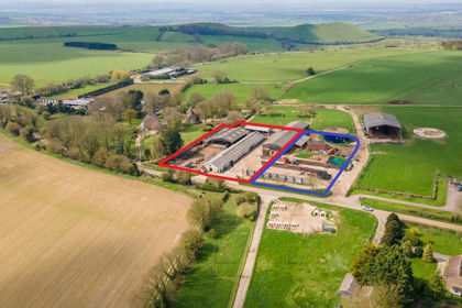
- Price
- Guide Price£550,000
- Size
- 1.26 acres
Added on 29/01/2026Development Land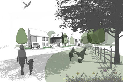
- Price
- Offers in Excess of£550,000
- Size
- 0.56 acres
Marston Lane, Frome, Frome, BA11, Frome, Somerset BA11 England
Added on 10/09/2026Development Land