Land & Building at Little Panson, Launceston
- Land size
- 19.91 acres
Key Features
- 19.91 acres
- Newly erected agricultural barn
- New Fencing & Gates
- Well maintained hedgerows
- Newly installed mains water system & troughs
- Mains electric supply
Description
A prime combination of grass leys & lower grazing meadows extending to around 19.91 acres (8.06ha) including a modern agricultural building. The land is split into three conveniently sized plots with well maintained hedgerows, new fencing and gates, newly installed mains water system with troughs throughout and mains electric. Further development potential subject to the necessary permissions.
Description
The property extends to around 19.91 acres (8.06ha) of level to gently sloping land, split into three conveniently sized parcels. Access is directly off the A388 into field no 9609 where the newly erected agricultural barn is located with planning permission 1/0570/2024/FUL consisting of a galvanized steel portal framed building measuring 11.96m x 18.46m, with crushed stone floor and timber clad sides all under a corrugated cement fibre roof with light sheets. The external yard area is fully fenced and railed with hardened stone, with a further gateway into the fields to the east.
Situation
The land is situated to the north of St Giles on the Heath, an idyllic Devonshire village with good access into the local town of Launceston just over the Cornish border. The land is 6 miles north of Launceston, 8 miles south of Holsworthy and 21 miles east of Oakhampton with good access on the A30.
Description
The property is an agricultural holding consisting of grass leys & lower grazing meadows extending to around 19.91 acres (8.06ha) including a modern agricultural building. The land is split into three conveniently sized plots with well maintained hedgerows, new fencing and gates, newly installed mains water system with troughs throughout and mains electric. Further development potential and suitable for the grazing of livestock, horses and ponies or for amenity use subject to the necessary permissions
Access
Access directly off the public highway to the west known as the A388.
Local Authority:
Torridge District Council, Riverbank House, Bideford, EX39 2QG.
Services
Water Supply: There is a metered mains water supply throughout the property servicing each field with a water trough.
Electricity: There is a new mains electrical supply connection to the property.
Boundaries, Roads & Fencing
The Purchaser/Purchasers shall be deemed to have full knowledge of the boundaries, and neither the Vendor, nor their Agent will be responsible for defining the ownership of the boundary fencing and hedges. Where it is known boundary ownership shall be marked by a 'T' on the sales plan.
Wayleaves, Rights & Easements:
The property is sold subject to any wayleaves, public or private rights of ways, easements and covenants and all outgoings, whether mentioned in the sales particulars or not. The property is not subject to any public footpaths or rights of way.
Planning & Development
The property is free from any restrictions for building however, there is an overage providing for the payment of 30% of the uplift in value as a result of the granting of any residential planning permission being for one unit or more, until February 2044
Environmental Stewardship
The property is subject to a Mid-Tier agreement – that if accepted it will transferred upon completion.
Tenure:
The property is available freehold with vacant possession. Land Registry Title DN767145
Viewing:
Viewing is available during daylight hours subject to prior registration with Rendells - Newton Abbot
Tel no. . Buyers will need to have a copy of the particulars to hand.
Health & Safety
Applicants/purchasers enter and view the property entirely at their own risk and no responsibility is accepted by the vendors or the agents.
Plan
The sale plan is for identification purposes only, all would be purchasers are advised to make a thorough inspection of the property to be aware of its full extent.
Directions
Leave the A30 at the Tavistock/A384 junction, turn onto the A388 and follow this road through the village of St Giles on the Heath until the property appears on the right.
What3Words:
///script.contrived.neon
Map Location
Property details
- Tenure
- Freehold
- Council Tax Band
- Ask Agent
- Date Posted
- 2026-01-29
Market Value Analysis
Compared with 84 Farmland & Pasture listings in South West England (10+ acres).
Utilities & Restrictions
Utilities
- Electricity
- Ask Agent
- Water
- Ask Agent
- Heating
- Ask Agent
- Broadband
- Ask Agent
- Sewerage
- Ask Agent
Rights & Restrictions
- Public Rights of Way
- Ask Agent
- Private Rights of Way
- Ask Agent
- Listed Property
- Ask Agent
- Restrictions
- Ask Agent
Property Features
- Accessibility
- Ask Agent
- Parking
- Ask Agent
- Garden
- Garden
Important notice: Information, maps and tags on this page are supplied by the advertising agent or generated automatically. LandSale has not verified them. Relying on these details is at your own risk, always carry out independent checks before committing to a purchase.
LandSale full disclaimer
Marketing information only - not formal particulars. The details on this website are provided for general guidance and do not constitute an offer or contract. Neither LandSale nor the advertising estate/land agent accepts responsibility for any inaccuracy.
1. Source of information
- Agent-supplied content: Core description, asking price, tenure, measurements, photographs and planning history are uploaded by the appointed agent, who remains solely responsible for their accuracy.
- Automated tags & categorisation: Property type, land-use class, acreage bands and similar labels may be applied by machine-learning models. They are intended as a helpful guide only and may not reflect the property's legal status or permitted use.
- Third-party & enriched data layers: Maps, boundary outlines, planning designations, soil reports, broadband coverage and other environmental or location-based insights are licensed from external suppliers. Such data are supplied “as is", may be incomplete or out of date and are subject to change without notice.
2. Verification required
Prospective purchasers must verify critical matters, including but not limited to planning permission, title boundaries, public rights of way, environmental constraints, acreage, services, access and VAT status, through their own inspections, specialist surveys, legal advisers and the selling agent before relying on the information or entering into any contract.
3. No warranty or liability
LandSale gives no warranty, express or implied, as to the accuracy, completeness or fitness for any particular purpose of the information displayed. LandSale shall not be liable for any loss, damage, cost or expense arising directly or indirectly from any use of or reliance on such information, save where liability may not be excluded by law.
4. Updates & feedback
If you believe any detail on this listing is inaccurate, please let us know. We will investigate and, where appropriate, update the listing or notify the agent.
© LandSale | Version 1.2 - January 2026
Similar properties for sale

- Price
- £300,000
- Size
- 26 acres
Added on 29/01/2026Grazing Land
- Price
- Guide Price£295,000
- Size
- 34.64 acres
Sampford Courtenay, Okehampton, EX20, Sampford Courtenay, Devon EX20 2RZ England
Added on 28/04/2026Farmland
- Price
- Offers in Excess of£300,000
- Size
- 30 acres
Parkham Ash, Bideford, EX39, Parkham, Devon EX39 5PS England
Added on 15/06/2026Grazing Land
- Price
- Guide Price£284,000
- Size
- 35.79 acres
Added on 29/01/2026Grazing Land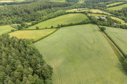
- Price
- Guide Price£280,000
- Size
- 30.47 acres
Added on 03/07/2026Vacant Land
- Price
- Guide Price£250,000
- Size
- 17.57 acres
Ipplepen, Newton Abbot, TQ12, Denbury and Torbryan, Devon TQ12 6ED England
Added on 21/05/2026Grazing Land
- Price
- £312,000
- Size
- 35.37 acres
Lot 1: 35.37 of Land at Bolsters Wood, Exeter, Exeter, Devon EX4 2NY England
Added on 29/01/2026Vacant Land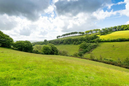
- Price
- Guide Price£350,000
- Size
- 20 acres
20 Acres of land and building, Bratton Fleming, Devon EX32 7QQ England
Added on 23/05/2026Grazing Land
- Price
- Offers in Excess of£375,000
- Size
- 46 acres
Added on 28/04/2026Farmland