Holbeach, PE12 7DE
- Land size
- 0.33 acres
Key Features
- Development Land
- Central Location
- Outlined Planning Permission for Three Terrace 3 beds and Two 3 bed semi's
- Planning Reference : H09-0913-22
- Close to Secondary School and Primary School
- Close to Local Shops and Doctor Surgery
Description
Location The site lies at the rear of 38 Fishpond Lane and has an existing access off Farrow Avenue, Holbeach. It is therefore within walking distance of Holbeach town centre and all the amenities which this Market town has to offer.
Description The land extends to approximately 1,351m² (0.33 acres). Access to the plot is proposed to come from Farrow Avenue. The plot is broadly rectangular in shape and has a frontage to Farrow Avenue of approximately 28m, and has an average depth of 55m.
The determined Outline Planning Consent is granted for 5 no. properties off a private drive, and indicatively is shown to comprise 3 x 3 Bedroom terrace houses at the rear and 2 x 3 bedroom semi-detached houses at the front of the site. The original buildings on site have now been demolished. The terrace houses are designed in a 'Dorma' style.
There is an Internal Drainage Board byelaw/easement running across the front of the site (9m), which restricts any development in this area, or planting.
The Registered Title number of the site is LL305652, and the property has a Restrictive covenant preventing the development of unsightly structures (to ensure only conventional dwellings i.e not Temporary or Commercial properties).
Planning Outline Planning Consent with All Matters Reserved, was granted by South Holland District Council - Reference No: H09-0913-22 on 10th October 2023. A copy of the formal Planning Consent is available from the Council's website - - or is available from the Agent's Spalding Office. Included in these Particulars is a copy of the plans determined by the Planning Application. The purchaser will be responsible for all costs in obtaining Reserved matters, and condition compliances consents, and for further studies required, which include contamination and drainage.
This planning consent was granted prior to the introduction of the new Biodiversity measures policy, and therefore there is only has a requirement to make 'simple' measures, and one swift brick is also to be added per dwelling.
Services Electricity has been disconnected, but a water standpipe is still in existence on the site. All mains services are believed to exist in Farrow Avenue, however prospective purchasers should make their own enquiries to establish the suitability and costs of connections.
Map Location
Property details
- Tenure
- Freehold
- Council Tax Band
- TBC
- Date Posted
- 2026-01-29
Utilities & Restrictions
Utilities
- Electricity
- Ask Agent
- Water
- Ask Agent
- Heating
- Ask Agent
- Broadband
- Ask Agent
- Sewerage
- Ask Agent
Rights & Restrictions
- Public Rights of Way
- Ask Agent
- Private Rights of Way
- Ask Agent
- Listed Property
- Ask Agent
- Restrictions
- Ask Agent
Property Features
- Accessibility
- Ask Agent
- Parking
- Parking Available
- Garden
- Ask Agent
Important notice: Information, maps and tags on this page are supplied by the advertising agent or generated automatically. LandSale has not verified them. Relying on these details is at your own risk, always carry out independent checks before committing to a purchase.
LandSale full disclaimer
Marketing information only - not formal particulars. The details on this website are provided for general guidance and do not constitute an offer or contract. Neither LandSale nor the advertising estate/land agent accepts responsibility for any inaccuracy.
1. Source of information
- Agent-supplied content: Core description, asking price, tenure, measurements, photographs and planning history are uploaded by the appointed agent, who remains solely responsible for their accuracy.
- Automated tags & categorisation: Property type, land-use class, acreage bands and similar labels may be applied by machine-learning models. They are intended as a helpful guide only and may not reflect the property's legal status or permitted use.
- Third-party & enriched data layers: Maps, boundary outlines, planning designations, soil reports, broadband coverage and other environmental or location-based insights are licensed from external suppliers. Such data are supplied “as is", may be incomplete or out of date and are subject to change without notice.
2. Verification required
Prospective purchasers must verify critical matters, including but not limited to planning permission, title boundaries, public rights of way, environmental constraints, acreage, services, access and VAT status, through their own inspections, specialist surveys, legal advisers and the selling agent before relying on the information or entering into any contract.
3. No warranty or liability
LandSale gives no warranty, express or implied, as to the accuracy, completeness or fitness for any particular purpose of the information displayed. LandSale shall not be liable for any loss, damage, cost or expense arising directly or indirectly from any use of or reliance on such information, save where liability may not be excluded by law.
4. Updates & feedback
If you believe any detail on this listing is inaccurate, please let us know. We will investigate and, where appropriate, update the listing or notify the agent.
© LandSale | Version 1.2 - January 2026
Listing agent
Longstaff, Spalding
5 New Road Spalding PE11 1BS
Similar properties for sale

- Price
- £189,000
- Size
- 0.33 acres
Added on 08/06/2026Development Land
- Price
- Guide Price£149,950
- Size
- 0.23 acres
Building Plots with Full Planning Consent, Surfleet, Lincolnshire PE11 4DH England
Added on 18/06/2026Building Plot Added on 15/06/2026Self Build Plot
- Price
- Guide Price£225,000
- Size
- 0.19 acres
Oxcroft Bank, Shepeau Stow, PE12 0TY, Whaplode, Lincolnshire PE12 0TY England
Added on 29/01/2026Development Land Added on 28/01/2026Building Plot
- Price
- £225,000
- Size
- 0.33 acres
Lancewood Gardens, Leverington, PE13, Leverington, Cambridgeshire PE13 5FN England
Added on 25/03/2026Building Plot
- Price
- Guide Price£200,000
North End, Wisbech, Wisbech, Cambridgeshire PE13 1PE England
Added on 28/02/2026Development Land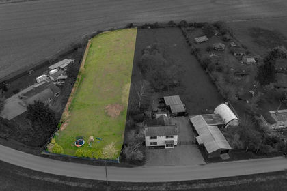
- Price
- £170,000
- Size
- 0.2 acres
Added on 11/05/2026Building Plot Added on 18/06/2026Building Plot
 Added on 29/01/2026Self Build Plot