Sturts Lane, Walton on the Hill, Tadworth, KT20
- Land size
- 26.23 acres
Key Features
- 26.23 acres mixed woodland
Description
Lot 4 E - FRITH PARK FARM, WALTON ON THE HILL, TADWORTH KT20 7RQ
Lot 4 E - Approximately 26.23 acres of woodland with access through adjoining land. Single block of mixed ancient and semi-ancient woodland.
WAYLEAVES, EASEMENTS AND RIGHTS OF WAY The Property is sold subject to or with the benefit of all existing wayleaves, easements, rights of way, covenants and restrictions, whether mentioned in these particulars or not. There are several overhead power cables which cross the land.
SERVICES None
BOUNDARIES The boundaries are based on the Ordnance Survey and are for reference only. The Purchaser will be deemed to have full knowledge of all boundaries and any error or mistake shall not be the responsibility of the Vendor or entitle any party to compensation in respect thereof.
TENURE Freehold with Vacent Possession
METHOD OF SALE For sale by Private Treaty as a whole. A 10% deposit is payable upon exchange of contracts.
VAT Any guide price quoted or discussed is exclusive of VAT. In the event that a sale of the property or any part of it or any right attached to it becomes a chargeable supply for the purposes of VAT such tax will be payable in addition
ANTI-MONEY LAUNDERING REGULATIONS In accordance with the Anti-Money Laundering Regulations 2017, once an offer has been accepted, the purchaser will be required to provide proof of identity and address prior to the instruction of solicitor.
USEFUL INFORMATION: DIRECTIONS Heading north on the B2032 towards Tadworth. After passing over the M25, approximately 200m there are signposts to Frith Park on the left hand side. Take Chequers Lane (B2220) and approximately 100m on left will be signposted Frith Park and Sturt’s Lane. Continue on along Sturt’s Lane over the bridge and Frith Park Farm (Lots 1 – 4) will be at the end of the lane.
VIEWING: Please call to arrange a viewing by prior appointment only.
LOCAL AUTHORITY Reigate & Banstead Borough Council Surrey County Council
VIEWING: White & Sons
IMPORTANT NOTE Whilst we endeavour to provide the most accurate details that we can, all text, photographs and plans are to be used for guidance purposes only and do not form any part of a contract. Services have not been checked by the agent.
Map Location
Property details
- Tenure
- Ask Agent
- Council Tax Band
- TBC
- Date Posted
- 2026-01-29
Market Value Analysis
Compared with 6 Woodland listings in South East England (25+ acres).
Utilities & Restrictions
Utilities
- Electricity
- Ask Agent
- Water
- Ask Agent
- Heating
- Ask Agent
- Broadband
- Ask Agent
- Sewerage
- Ask Agent
Rights & Restrictions
- Public Rights of Way
- Ask Agent
- Private Rights of Way
- Ask Agent
- Listed Property
- Ask Agent
- Restrictions
- Ask Agent
Property Features
- Accessibility
- Ask Agent
- Parking
- Ask Agent
- Garden
- Ask Agent
Important notice: Information, maps and tags on this page are supplied by the advertising agent or generated automatically. LandSale has not verified them. Relying on these details is at your own risk, always carry out independent checks before committing to a purchase.
LandSale full disclaimer
Marketing information only - not formal particulars. The details on this website are provided for general guidance and do not constitute an offer or contract. Neither LandSale nor the advertising estate/land agent accepts responsibility for any inaccuracy.
1. Source of information
- Agent-supplied content: Core description, asking price, tenure, measurements, photographs and planning history are uploaded by the appointed agent, who remains solely responsible for their accuracy.
- Automated tags & categorisation: Property type, land-use class, acreage bands and similar labels may be applied by machine-learning models. They are intended as a helpful guide only and may not reflect the property's legal status or permitted use.
- Third-party & enriched data layers: Maps, boundary outlines, planning designations, soil reports, broadband coverage and other environmental or location-based insights are licensed from external suppliers. Such data are supplied “as is", may be incomplete or out of date and are subject to change without notice.
2. Verification required
Prospective purchasers must verify critical matters, including but not limited to planning permission, title boundaries, public rights of way, environmental constraints, acreage, services, access and VAT status, through their own inspections, specialist surveys, legal advisers and the selling agent before relying on the information or entering into any contract.
3. No warranty or liability
LandSale gives no warranty, express or implied, as to the accuracy, completeness or fitness for any particular purpose of the information displayed. LandSale shall not be liable for any loss, damage, cost or expense arising directly or indirectly from any use of or reliance on such information, save where liability may not be excluded by law.
4. Updates & feedback
If you believe any detail on this listing is inaccurate, please let us know. We will investigate and, where appropriate, update the listing or notify the agent.
© LandSale | Version 1.2 - January 2026
Listing agent
White & Sons, Oxted
39-41 Station Road East, Oxted, RH8 0BD
Similar properties for sale

- Price
- Guide Price£200,000
- Size
- 16.5 acres
Farley Heath, Albury, Guildford, Albury, Surrey GU5 9ER England
Added on 28/01/2026Woodland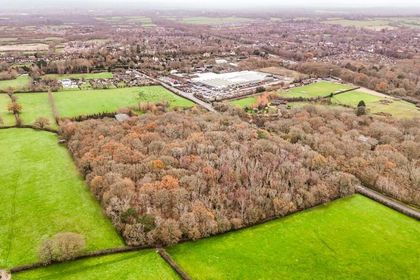
- Price
- Offers Over£150,000
- Size
- 10 acres
Brighton Road, Hassocks, BN6, Hassocks, West Sussex BN6 9LY England
Added on 17/07/2026Woodland
- Price
- Guide Price£120,000
- Size
- 11.09 acres
Green Foot Wood, Nr. Royal Tunbridge Wells, TN3, Frant, East Sussex TN3 9HG England
Added on 19/05/2026Woodland
- Price
- Offers in Excess of£150,000
- Size
- 9.37 acres
Added on 29/01/2026Pasture
- Price
- Offers in Region of£125,000
- Size
- 8 acres
Old Lewes Racecourse, Lewes, Lewes, East Sussex BN7 1EQ England
Added on 29/01/2026Amenity Land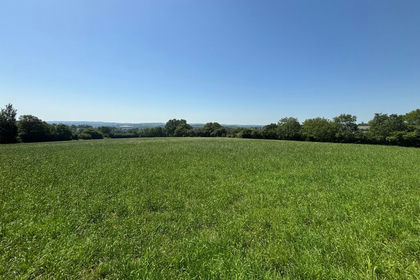
- Price
- Offers in Excess of£200,000
- Size
- 23.99 acres
Land off Buttons Lane, Wadhurst, East Sussex, Wadhurst, East Sussex TN5 6NP England
Added on 07/07/2026Pasture
- Price
- Offers in Excess of£200,000
The Old Tallow House, Burwash High Street, TN19, Burwash, East Sussex TN19 7EN England
Added on 19/02/2026Development Land
- Price
- Offers in Excess of£200,000
- Size
- 6.01 acres
Meonmarsh, Bridge Street, Fareham, Hampshire, PO14, Hamble Valley, Hampshire PO14 3ET England
Added on 29/01/2026Wetland
- Price
- Guide Price£199,950
- Size
- 7.66 acres
Calbourne, Isle Of Wight, Calbourne, Newtown and Porchfield, Isle of Wight PO30 4HZ England
Added on 18/06/2026Grazing Land
- Price
- Guide Price£150,000
- Size
- 2.44 acres
Added on 20/03/2026Vacant Land