Llangattock Lingoed, Abergavenny
- Land size
- 194 acres
- Bedrooms
- 5
Key Features
- MAGNIFICENT LIVESTOCK FARM IN PEACEFUL LOCATION
- GRADE II LISTED FIVE BEDROOM FARMHOUSE
- SUBSTANTIAL THREE BEDROOM MODERN BUNGALOW
- EXTENSIVE RANGE OF MODERN AND TRADITIONAL AGRICULTURAL BUILDINGS
- APPROX 194 ACRES MAINLY LEVEL PASTURE LAND
- FOR SALE AS A WHOLE OR IN 5 LOTS
Description
SITUATION
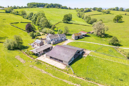
Upper Kathlea Farm occupies an unspoilt rural location in the parish of Llangattock Lingoed in North Monmouthshire.
The property is conveniently situated within easy reach of the towns of Abergavenny (8 miles) and Monmouth (14 miles). Both towns offer an extensive range of shopping, educational and recreational amenities.
The farm is well located within easy reach of the M4 which ensures excellent road communications throughout the United Kingdom.
POST CODE
NP7 8NA
What3Words: arise.showcase.trying (Upper Kathlea Farm)
LOT 1
Upper Kathlea Farmhouse, extensive range of modern and traditional agricultural buildings with 118.70 acres of pasture land. PRICE GUIDE £1,750,000
LOT 2
The Paddocks, a modern four bedroom bungalow set in approximately 0.31 acres. PRICE GUIDE £400,000
LOT 3
Modern agricultural buildings with approximately 30.29 acres of pasture land. PRICE GUIDE £350,000
LOT 4
Approximately 31.75 acres of level pasture land adjacent to Pool Hall Road. PRICE GUIDE £285,000
LOT 5
Approximately 12.95 acres of permanent pasture land at Church Meadow, Llangattock Lingoed. PRICE GUIDE £90,000.
TENURE
The properties are freehold with vacant possession upon completion. Both dwellings are subject to Agricultural Occupancy Conditions (AOC's).
SERVICES
Mains Electricity is connected to the properties.
Private Water supply from a natural spring.
Drainage is to a private disposal system.
Oil fired Central Heating System in both dwellings.
LOCAL AUTHORITY
Monmouthshire Council.
COUNCIL TAX
Farmhouse - Band H. The Paddocks - Band G.
FIXTURES AND FITTINGS
Only fixtures and fittings mentioned in these particulars are included within the sale of the freehold. Any others are expressly excluded.
SPORTING AND MINERAL RIGHTS
The Sporting and Mineral Rights are included in the sale insofar as they are owned.
RIGHTS OF WAY
The properties are sold subject to, and with the benefit of, all existing rights of way, light, support, drainage, water and electricity supplies and other rights and obligations, easements, quasi easements and restrictive covenants and all existing and proposed wayleaves or masts, pylons, stays, cables, drains and water, gas or other pipes, whether referred to in the general remarks and stipulations or particulars of sale or not, and to the provisions of any planning scheme of County or Local Authorities.
PLANS, AREAS AND SCHEDULES
These are based on the most recent Ordnance Survey Promap Series. The purchasers shall be deemed to have satisfied themselves as the boundaries and the area of the land. Any error or mis statement shall not annul the sale or entitle any party to compensation whatsoever.
BASIC PAYMENT SCHEME
No Basic Payment Scheme Entitlements are included in the sale.
MONEY LAUNDERING
We are required by Law to verify the identity and address of everyone who offers, bids or buys property. Please provide the following documentation with your offer:-
1. Photo ID e.g. Passport or Driving Licence. 2. Residency ID e.g. current Utility Bill.
HEALTH & SAFETY
Neither the seller not the selling Agents are responsible for the safety of those viewing the properties and accordingly, all individuals do so at their own risk
VIEWING
Viewing is strictly by appointment only with the joint agents:
RG and RB Williams.
Williams Associates.
LOT 1
UPPER KATHLEA FARMHOUSE
FARMBUILDINGS AND 118.70 ACRES
Upper Kathlea Farm is approached over a private entrance drive leading off a quiet No Through Road. It occupies an elevated location commanding outstanding views over the surrounding countryside.
The farmhouse is believed to date back to the 17th Century and is Grade II listed. It is principally constructed of stone elevations under a slate roof. It contains a wealth of period features throughout.
The spacious well appointed accommodation includes:
GROUND FLOOR
Porch, Hallway, Sitting Room, Kitchen/Conservatory, Office/Hallway, Dining Room, downstairs w.c and Boiler Room.
FIRST FLOOR
Landing, Four Bedrooms (one ensuite), Family Bathroom and Lounge.
SECOND FLOOR
Large Attic Room/Bedroom with separate Bathroom.
The property is subject to an Agricultural Occupancy Condition (AOC). Further information can be found on Monmouthshire County Council Planning Portal under Planning Reference: M3817.
AGRICULTURAL BUILDINGS
The agricultural buildings are of modern and traditional construction and conveniently situated to the farmhouse. The traditional stone buildings offer scope for alternative uses (subject to Planning Consent).
The modern buildings comprise an extensive range of steel framed and timber structures which are principally used for livestock, fodder and machinery storage. The buildings have been maintained to a good standard and are ideal for livestock rearing.
THE LAND
Extending to approximately 118.70 acres, the land is contained within a ring fence surrounding the homestead. It comprises a mainly level area of permanent pasture which is divided into good size enclosures. There is ample shade and shelter for livestock. All fields have access to water tanks supplied by the borehole/spring.
The soil is a medium loam which is ideal for livestock production. All of the land is classified as Grade 2 and 3 according to Agricultural Land Classification Predictive Map (Wales).
LOT 2
THE PADDOCKS
The Paddocks is situated off the entrance drive to Upper Kathlea Farm. It is believed to have been constructed in the late 1990's of brick elevations under a slate roof.
The spacious accommodation includes:
Sun Room, Kitchen, Living Room, Dining Room, Office, Three Bedrooms (one ensuite), Family Bathroom, Utility Room and Shower Room.
The property sits in a plot of approximately 0.31 acres and includes a patio area, large garden and lawns together with gravelled parking area.
The property is subject to an Agricultural Occupancy Condition (AOC). Further information can be found on Monmouthshire County Council Planning Portal under Planning Reference: M3817.
LOT 3
RANGE OF MODERN BUILDINGS AND 30.29 ACRES
Situated adjacent to Upper Kathlea Farm and has direct frontage to an unclassified Council Road.
THE MODERN BUILDINGS
The buildings comprise two steel framed covered cattle yards with an earth bank silage clamp.
THE LAND
The land is contained in a ring fence surrounding the buildings. It comprises a mainly level area of pasture extending to some 30.29 Acres.
LOT 4
31.75 ACRES PASTURE LAND AT POOL HALL
Situated off Pool Hall Road from Llanvetherine to Llangattock Lingoed. The land comprises two excellent mainly level areas of pasture with extensive roadside frontage. The soil is a versatile loam.
The whole extends to approximately 31.75 acres.
LOT 5
12.95 ACRES OF LAND AT CHURCH MEADOW
Situated to the South of the village of Llangattock Lingoed. The land is of excellent level permanent pasture in a single enclosure. The property has frontage to the Full Brook.
The land comprising of a single enclosure of gently undulating permanent pasture and extends to approximately 12.95 acres. There are a number of mature trees around the perimeter and a natural water course along the southern boundary.
Map Location
Property details
- Tenure
- Freehold
- Council Tax Band
- Ask Agent
- Date Posted
- 2026-01-29
Market Value Analysis
Compared with 9 Livestock Farms listings in Wales (100+ acres).
Utilities & Restrictions
Utilities
- Electricity
- Ask Agent
- Water
- Ask Agent
- Heating
- Ask Agent
- Broadband
- Ask Agent
- Sewerage
- Ask Agent
Rights & Restrictions
- Public Rights of Way
- Ask Agent
- Private Rights of Way
- Ask Agent
- Listed Property
- Ask Agent
- Restrictions
- Ask Agent
Listed status, conservation areas and planning constraints for this location are in the full report.
Property Features
- Accessibility
- Ask Agent
- Parking
- Parking Available
- Garden
- Garden
Beyond the particulars: planning activity, flood history, heritage and ground risks, checked for this exact spot.
Connectivity
Broadband
Fastest speed available at this postcode
5 Mbps
Under 10 Mbps here
Suitable for
- Basic browsing & email
Mobile signal
Outdoor predictions; indoor signal depends on building materials.
Ofcom Connected Nations postcode-level predictions. Speeds and signal are modelled, not measured, and vary between addresses and providers.
Signal is the easy part. Planning activity, flood history and protected designations here are in the full report.
Nearest Schools
Primary
- Cross Ash County Primary School2.2 miles
- Pupils
- 166
- Type
- Infants & Juniors
- Language
- English medium school / provision
- Llanvihangel Crucorney County Primary School2.4 miles
- Pupils
- 67
- Type
- Infants & Juniors
- Language
- English medium school / provision
- Llantilio Pertholey CV Primary5.1 miles
- Pupils
- 203
- Type
- Infants & Juniors
- Language
- English medium school / provision
- Ysgol Gymraeg Y Fenni5.3 miles
- Pupils
- 271
- Type
- Nursery, Infants & Juniors
- Language
- Welsh medium school / provision (including transitional)
- King Henry VIII 3196 miles
- Pupils
- 1,310
- Type
- Middle (ages 3-19)
- Language
- English medium school / provision
Secondary
- King Henry VIII 3196 miles
- Pupils
- 1,310
- Type
- Middle (ages 3-19)
- Language
- English medium school / provision
- Crickhowell High School9.9 miles
- Pupils
- 942
- Type
- Secondary (ages 11-19)
- Language
- English medium school / provision
- Monmouth Comprehensive School10 miles
- Pupils
- 1,696
- Type
- Secondary (ages 11-19)
- Language
- English medium school / provision
- Brynmawr Foundation School12 miles
- Pupils
- 569
- Type
- Secondary (ages 11-16)
- Language
- English medium school / provision
- Abersychan Comprehensive13 miles
- Pupils
- 739
- Type
- Secondary (ages 11-16)
- Language
- English medium school / provision
Distances are straight-line from the advertised location. Source: the national school registers (DfE, Welsh Government, Scottish Government) and Ofsted.
Schools are just the start: sold prices nearby, planning activity and any flood history are in the full report.
Amenities
Supermarket
GP surgery
Pharmacy
Walking trail
Straight-line distances from the advertised location. Sources: NHS records, Geolytix supermarket locations, OS Open Greenspace and the national trails registers.
The area stacks up? Now check the location itself: planning nearby, protected designations and past flooding.
Getting Around
Nearest station
Nearest bus stop
Typical drive times
Straight-line distances from the advertised location; drive times are typical free-flow times over OpenStreetMap road data, so allow more at peak. Public transport locations from DfT NaPTAN.
Easy to reach matters. So do planning activity, flood history and ground risks: all in the full report.
Flood Risk
From Natural Resources Wales flood map open data, checked around the advertised map pin and allowing for the listed acreage where known. This summary comes from LandSale, the advertising platform, not from the listing agent, and is not part of the agent's particulars. Risk can vary across a single holding, so verify anything critical through your own searches before committing.
Rivers and the sea
Surface water
Mapped within the area searched, not at the advertised map pin itself.
The detail behind these bandings
The full report pinpoints where this location sits on the flood maps, and runs the deeper checks that usually only surface after an offer.
- Exact flood zones & annual chances (included in the full report)
- Any recorded past flooding (included in the full report)
- Planning activity nearby (included in the full report)
- Heritage & conservation (included in the full report)
- Protected nature designations (included in the full report)
- Ground risks (included in the full report)
- Sold prices nearby (included in the full report)
£14.99 · one-off purchase
By LandSale, the platform. Not provided by the listing agent. Ready in about a minute.
Important notice: Information, maps and tags on this page are drawn from the advertising agent's marketing materials or generated automatically. LandSale has not verified them. Relying on these details is at your own risk, always carry out independent checks before committing to a purchase.
LandSale full disclaimer
Marketing information only - not formal particulars. The details on this website are provided for general guidance and do not constitute an offer or contract. Neither LandSale nor the advertising estate/land agent accepts responsibility for any inaccuracy.
1. Source of information
- Listing content: Core description, asking price, tenure, measurements, photographs and planning history originate from the marketing materials of the advertising estate or land agent. LandSale does not author this content and cannot guarantee its accuracy.
- Automated tags & categorisation: Property type, land-use class, acreage bands and similar labels may be applied by machine-learning models. They are intended as a helpful guide only and may not reflect the property's legal status or permitted use.
- Third-party & enriched data layers: Maps, boundary outlines, planning designations, soil reports, broadband coverage and other environmental or location-based insights are licensed from external suppliers. Such data are supplied “as is", may be incomplete or out of date and are subject to change without notice.
2. Verification required
Prospective purchasers must verify critical matters, including but not limited to planning permission, title boundaries, public rights of way, environmental constraints, acreage, services, access and VAT status, through their own inspections, specialist surveys, legal advisers and the selling agent before relying on the information or entering into any contract.
3. No warranty or liability
LandSale gives no warranty, express or implied, as to the accuracy, completeness or fitness for any particular purpose of the information displayed. LandSale shall not be liable for any loss, damage, cost or expense arising directly or indirectly from any use of or reliance on such information, save where liability may not be excluded by law.
4. Updates & feedback
If you believe any detail on this listing is inaccurate, please let us know. We will investigate and, where appropriate, update the listing or notify the agent.
© LandSale | Version 1.3 - August 2026

Listing agent
RG & RB Williams, Ross-On-Wye
Ross Auction Centre, Netherton Road, Overross, Ross-On-Wye, HR9 7QQ
Contact RG & RB Williams, Ross-On-Wye
Ross Auction Centre, Netherton Road, Overross, Ross-On-Wye, HR9 7QQ
View agent profileSimilar properties for sale
- Price
- Guide Price£2,395,000
- Size
- 116.17 acres
Great Lanolway, Llansoy, Usk, Monmouthshire, NP15, Llantrisant Fawr, Monmouthshire NP15 Wales
Added on 29/01/2026Farm
- Price
- Guide Price£2,900,000
- Size
- 190.39 acres
Talybont-On-Usk, Brecon, Powys, LD3, Talybont-on-Usk, Powys LD3 Wales
Added on 29/01/2026Farm
- Price
- £2,900,000
- Size
- 190.39 acres
Maesmawr Farm Talybont-on-usk, Talybont-on-Usk, Powys LD3 Wales
Added on 29/01/2026Farm
- Price
- £2,900,000
- Size
- 190.39 acres
Maesmawr Farm Talybont-on-usk, Talybont-on-Usk, Powys LD3 Wales
Added on 29/01/2026Farm
- Price
- Guide Price£3,000,000
- Size
- 176.52 acres
Ashperton, Ledbury, Ashperton, Herefordshire, County of HR8 England
Added on 11/07/2026Farm
- Price
- Guide Price£2,200,000
- Size
- 130 acres
Added on 25/07/2026Farm
- Price
- £3,145,000
- Size
- 241.52 acres
Parsonage Farm, Kyre, Tenbury Wells, Worcestershire, Kyre, Worcestershire WR15 England
Added on 14/05/2026Farm
- Price
- Guide Price£2,850,000
- Size
- 225.28 acres
Wern Fawr Farm, Ystradowen, Cowbridge, CF71, Welsh St. Donats, Vale of Glamorgan CF71 Wales
Added on 18/03/2026Farm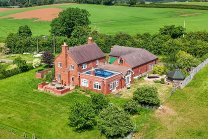
- Price
- Guide Price£3,000,000
- Size
- 144.5 acres
Sinton Green, Hallow, WR2, Grimley, Worcestershire WR2 England
Added on 16/06/2026Farm