
Rackenford, Tiverton, EX16
- Land size
- 2.02 acres
Key Features
- Outstanding rural development opportunity
- Adaptable agricultural barn with pp for light industrial use
- Conveniently situated for access to the A361 North Devon link road
- Set in its own pasture land with superb countryside views
- Private access with ample parking
- Extending in total to about 2.02 Acres
Description
An opportunity to acquire an adaptable agricultural building occupying an outstanding rural position with change of use planning consent for a light industrial business unit, together with the adjoining pasture land. In all about 2.02 Acres.
This sale affords prospective purchasers a wonderful opportunity to acquire a modern agricultural barn which now has the benefit of planning permission for change of use to a light industrial unit with associated track access and hard standing area. The barn occupies an outstanding and yet convenient rural position enjoying excellent access from the A361 North Devon Link road. Benefiting from superb views over its own land and the surrounding unspoilt countryside, the barn offers the potential to create a useful commercial premises, with a gross internal floor space of approx. 2,572sqft (239m²).
The property briefly comprises a modern agricultural building of principally steel framed and profile steel roofed and clad construction, with an earth and wood chip floor. The barn has recently obtained full planning consent for conversion into a single storey commercial business unit with a proposed layout to comprise a Foyer, Reception Office, separate Office, Ladies and Gents Cloakrooms, a Kitchen and a large open plan Business Area with a roller shutter door and Plant Room off.
For the ground floor layout please refer to the above proposed floor plan.
Outside the planning consent allows for the creation of an access track leading from the council road and a large hardstanding area with ample parking. Adjoining the barn is an area of principally level and very gently undulating productive pasture land, enjoying superb southerly views. The approved plans also include a proposed Biodiversity Net Gain area and bund immediately adjoining the barn. There may be potential for the creation of small paddocks, orchards or other amenity areas on the remainder of the land to complement the setting of the building.
Whilst planning consent for light industrial use has already been obtained, there may be scope to consider other alternative uses within the building subject to obtaining any necessary consents.
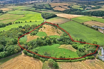
In total, the property extends to about 2.02 Acres, as shown shaded on the attached identification plan.
Tenure
The property if of freehold tenure with vacant possession available upon completion.
Services & Outgoings
The property does not currently benefit from any mains services. We understand that mains water may be available at Batsworthy Cross although prospective purchasers should make their own enquiries regarding the proximity and availability of water and any other mains services. The Purchaser(s) will need to install their own independent private drainage system.
North Devon Council Business Rates - to be assessed. Commercial EPC rating to be confirmed.
Town & Country Planning
Planning consent was obtained from North Devon Council in May 2025 for ‘Change of use of land and conversion of agricultural building to Class E(g) (I, ii, iii) light industrial business unit and associated development including access track and hardstanding area’. Copies of the planning approval and approved plans, together with the relevant supporting documentation are available to view via the North Devon Council planning portal using the Application Reference No: 79720.
The property, notwithstanding any description contained in these particulars, is sold subject to any Development Plan, Tree Preservation Order, Town Planning Scheme, Resolution Notice, which may be or may come to be in force and also subject to any statutory provision or by-laws without any obligation on the part of the vendor to specify them. The barn is situated near to the wind turbines at Batsworthy Cross.
Right of way, Easements, Wayleaves, Etc.
Access to the land from the council highway will be via an unrestricted right of way over the area shown coloured brown. The access will be granted at all times and for all purposes, with or without vehicles.
We are not aware of any public or private rights of way across the land.
The property, as far as required by the Vendors, will be conveyed subject to all rights of way, easements and wayleaves of telegraph and telephone poles, stays and wires, electric pylons, poles and cables, drains, water and gas pipes at present erected on and passing over or under the property and subject to the agreements affecting the same (if any).
Fencing Obligation
The Purchaser(s) will be responsible, within two months of the completion date, for the erection and future maintenance of a new access gate and stock proof fence and between points A, B and C shown on the identification plan.
Sporting & Mineral Rights
The sporting and mineral rights across the land, insofar as they are owned, will be included in the freehold sale.
Designations
The land lies in a Nitrate Vulnerable Zone.
Designations
The land lies in a Nitrate Vulnerable Zone.
Additional Information
Mobile Coverage: Potentially available via THREE, O2, EE and VODAFONE (Based on Ofcom data). For an indication of specificspeeds and supply or coverage in the area we recommend that prospective purchasers contact their our own provider.
Flooding: The land is in an area at a very low risk of flooding from River/Sea and from Surface Water (defined as the chance of flooding each year as less than 0.1%).
Occupying a tucked away rural position the barn lies within the attractive and gently undulating band of countryside between South Molton and Tiverton. Situated a short distance to the west of Batsworthy Cross, which is a junction on the South Molton to Rackenford/Tiverton road, near the Batsworthy wind turbines. Nearby Rackenford is a popular village affording a good range of local amenities including a primary school, village stores/post office, parish church and local social club.
Despite its rural position the property still enjoys easy access to the surrounding districts and main routes of communication with the A361 North Devon link road lying about a 2-3 minute drive away and providing an easy link to the bustling towns of South Molton, Tiverton and Barnstaple, each providing an extensive range of everyday shopping, recreational and educational facilities. The A361 also provides access to the M5 motorway (Junction 27). Mainline intercity rail links are available at Tiverton Parkway, with international airports at Exeter and Bristol.
The land is surrounded by picturesque Devon countryside providing a wealth of recreational activities including walking, horse riding, cycling, fishing on the rivers Taw and Mole, hunting, shooting and golf courses at Libbaton, Barnstaple and Tiverton. To the north the Exmoor National Park offers beautiful moorland scenery with many foot and bridle paths and the stunning North Devon coastline, with popular sandy beaches of Instow, Saunton Sands, Croyde Bay, Putsborough and Woolacombe.
Directions
From the Square in South Molton head eastwards along East Street and follow the B3227 out of the town for about 2 miles until reaching Bish Mill. At Bish Mill turn right, signposted for Bishops Nympton and Rackenford. Stay on this road for about 5.6 miles and at Batsworthy Cross turn right. Follow the road for about 150 yards and the property will be found on the left hand side, denoted by the Agents ‘For Sale’ board.
Alternatively, if approaching from the west on the A361 North Devon link road, at Moortown Cross, take the exit signed for Rose Ash, Ash Mill and Bishops Nympton. Follow the road around to the right and after about 0.5 miles turn left at Beaples Moor Cross. Continue for about 0.8 miles to Batsworthy Cross, go straight over the crossroads and the property will be found after about 150 yards on the left hand side, denoted by the Agents ‘For Sale’ board.
What3Words - For the exact location of the entrance to the property download the App and enter:- lordship.zest.braced
Please Note:- You are strongly advised to follow the directions set out above rather than relying on satellite navigation.
Map Location
Property details
- Tenure
- Freehold
- Council Tax Band
- TBC
- Date Posted
- 2026-01-29
Market Value Analysis
Compared with 178 Development Land listings in South West England (1+ acres).
Property Brochure
Seen the details? The full report adds the independent checks: planning activity, flood history, heritage and ground.
Utilities & Restrictions
Utilities
- Electricity
- Ask Agent
- Water
- Ask Agent
- Heating
- Ask Agent
- Broadband
- Ask Agent
- Sewerage
- Ask Agent
Rights & Restrictions
- Public Rights of Way
- Ask Agent
- Private Rights of Way
- Ask Agent
- Listed Property
- Ask Agent
- Restrictions
- Ask Agent
Listed status, conservation areas and planning constraints for this location are in the full report.
Property Features
- Accessibility
- Ask Agent
- Parking
- Parking Available
- Garden
- Garden
Beyond the particulars: planning activity, flood history, heritage and ground risks, checked for this exact spot.
Connectivity
Broadband
Fastest speed available at this postcode
1.8 Gbps
Gigabit full fibre
Suitable for
- 4K streaming on every screen
- Full-time home working
- Online gaming & big downloads
Fixed wireless access may also be an option here.
Mobile signal
Predicted 4G and 5G signal; indoor signal depends on building materials.
Ofcom Connected Nations postcode-level predictions. Speeds and signal are modelled, not measured, and vary between addresses and providers.
Signal is the easy part. Planning activity, flood history and protected designations here are in the full report.
Nearest Schools
Primary
- Rackenford Church of England Primary School2.9 milesNo Ofsted rating
- Ages
- 4 to 11
- Pupils
- 53
- Type
- Voluntary aided school
- Faith
- Church of England
- Bishops Nympton Primary School3.8 milesOfsted: Good *
- Ages
- 2 to 11
- Pupils
- 80
- Type
- Community school
- Witheridge Church of England Primary Academy4 milesOfsted report card · Jan 2026
- Ages
- 2 to 11
- Pupils
- 135
- Type
- Academy converter
- Faith
- Church of England
- East Worlington Primary School4.8 milesNo Ofsted rating
- Ages
- 0 to 11
- Pupils
- 75
- Type
- Academy converter
- East Anstey Primary School5 milesOfsted: Good
- Ages
- 2 to 11
- Pupils
- 35
- Type
- Community school
Secondary
- South Molton Community College6.7 milesOfsted: Good *
- Ages
- 11 to 16
- Pupils
- 656
- Type
- Foundation school
- Chulmleigh Community College8.6 milesNo Ofsted rating
- Ages
- 11 to 16
- Pupils
- 735
- Type
- Academy converter
- Tiverton High School9.7 milesOfsted: Inadequate *
- Ages
- 11 to 16
- Type
- Academy sponsor led
- Queen Elizabeth's13 milesOfsted report card · May 2026
- Ages
- 11 to 18
- Pupils
- 1,096
- Type
- Academy converter
- Cullompton Community College16 milesOfsted: Good
- Ages
- 11 to 16
- Pupils
- 746
- Type
- Academy converter
* Latest graded judgement covers quality of education only; no overall grade was issued under the 2024-25 inspection framework.
Distances are straight-line from the advertised location. Source: the national school registers (DfE, Welsh Government, Scottish Government) and Ofsted.
Schools are just the start: sold prices nearby, planning activity and any flood history are in the full report.
Amenities
Supermarket
GP surgery
Pharmacy
Hospital
Straight-line distances from the advertised location. Sources: NHS records, Geolytix supermarket locations, OS Open Greenspace and the national trails registers.
The area stacks up? Now check the location itself: planning nearby, protected designations and past flooding.
Getting Around
Nearest station
Nearest bus stop
Typical drive times
Straight-line distances from the advertised location; drive times are typical free-flow times over OpenStreetMap road data, so allow more at peak. Public transport locations from DfT NaPTAN.
Easy to reach matters. So do planning activity, flood history and ground risks: all in the full report.
Flood Risk
Environment Agency open data, checked around the advertised map pin for the listed acreage. Long-term risk counts flood defences; the planning map's flood zones do not. Provided by LandSale, not the listing agent, and not part of the agent's particulars. Risk varies across a holding, so verify before committing.
Rivers and the sea
Planning map: Flood Zone 1.
Surface water
These bandings are the summary. Where this location sits on the flood maps, plus planning activity, heritage and ground risks, is in the full report.
Important notice: Information, maps and tags on this page are drawn from the advertising agent's marketing materials or generated automatically. LandSale has not verified them. Relying on these details is at your own risk, always carry out independent checks before committing to a purchase.
LandSale full disclaimer
Marketing information only - not formal particulars. The details on this website are provided for general guidance and do not constitute an offer or contract. Neither LandSale nor the advertising estate/land agent accepts responsibility for any inaccuracy.
1. Source of information
- Listing content: Core description, asking price, tenure, measurements, photographs and planning history originate from the marketing materials of the advertising estate or land agent. LandSale does not author this content and cannot guarantee its accuracy.
- Automated tags & categorisation: Property type, land-use class, acreage bands and similar labels may be applied by machine-learning models. They are intended as a helpful guide only and may not reflect the property's legal status or permitted use.
- Third-party & enriched data layers: Maps, boundary outlines, planning designations, soil reports, broadband coverage and other environmental or location-based insights are licensed from external suppliers. Such data are supplied “as is", may be incomplete or out of date and are subject to change without notice.
2. Verification required
Prospective purchasers must verify critical matters, including but not limited to planning permission, title boundaries, public rights of way, environmental constraints, acreage, services, access and VAT status, through their own inspections, specialist surveys, legal advisers and the selling agent before relying on the information or entering into any contract.
3. No warranty or liability
LandSale gives no warranty, express or implied, as to the accuracy, completeness or fitness for any particular purpose of the information displayed. LandSale shall not be liable for any loss, damage, cost or expense arising directly or indirectly from any use of or reliance on such information, save where liability may not be excluded by law.
4. Updates & feedback
If you believe any detail on this listing is inaccurate, please let us know. We will investigate and, where appropriate, update the listing or notify the agent.
© LandSale | Version 1.3 - August 2026
Listing agent
Greenslade Taylor Hunt, South Molton23 Broad Street, South Molton, EX36 3AQ
View agent profileSimilar properties for sale
- Price
- £100,000
- Size
- 9.69 acres
Added on 29/09/2026Undeveloped Land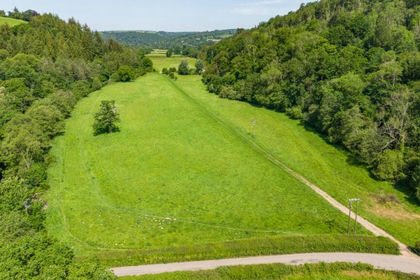
- Price
- Guide Price£120,000
- Size
- 10.28 acres
Lot 5: Land At Perry Farm, Dulverton, Somerset, TA22, Brushford, Somerset TA22 England
Added on 17/09/2026Pasture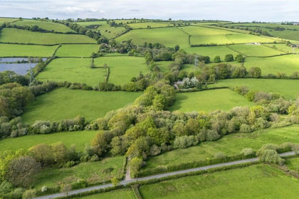
- Price
- Guide Price£100,000
- Size
- 29.81 acres
Shillingford, Tiverton, Devon, EX16, Bampton, Devon EX16 England
Added on 20/05/2026Grazing Land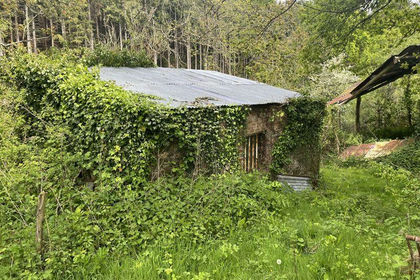
- Price
- £120,000
- Size
- 1.15 acres
Lot 3: Keepers Cottage & Land at Bolsters Wood, Exeter, Exeter, Devon EX4 England
Added on 29/01/2026Agricultural Land
- Price
- Guide Price£120,000
- Size
- 2.25 acres
Park Road, Okehampton, EX20, Hatherleigh, Devon EX20 England
Added on 04/06/2026Building Plot
- Price
- Offers in Region of£75,000
- Size
- 9.46 acres
Added on 07/03/2026Grazing Land
- Price
- Guide Price£110,000
- Size
- 11.12 acres
Whitestaunton, Chard, Somerset, Whitestaunton, Somerset TA20 England
Added on 22/06/2026Pasture
- Price
- Guide Price£90,000
- Size
- 7.86 acres
Lot 4, Land At Stockers Farm, Northleigh, Colyton, Devon, EX24, Colyton, Devon EX24 England
Added on 25/09/2026Pasture
- Price
- Fixed Price£95,000
- Size
- 5 acres
Added on 17/10/2026Vacant Land
- Price
- Guide Price£75,000
- Size
- 3.6 acres
Combeinteignhead, Newton Abbot - Lot 1, TQ12, Newton Abbot, Devon TQ12 England
Added on 15/10/2026Agricultural Land