Shrewsbury, Shropshire, SY5
- Land size
- 809.87 acres
- Bedrooms
- 8
- Bathrooms
- 6
Key Features
- Impressive Grade II listed Hall with walled garden and parkland.
- Self-contained 2 bedroom staff flat.
- Indoor swimming pool complex and tennis court.
- Substantial residential property portfolio.
- Planning for conversion of traditional buildings.
- In hand productive arable land with irrigation reservoir.
- Attractive pasture and amenity woodland.
- Sporting rights and equestrian.
Description
Eaton Mascott Estate presents a rare opportunity to acquire a prestigious country estate in one of Shropshire's most scenic locations, offering historic elegance, exceptional privacy, and lifestyle amenities.
All in about 809.87 acres (327.75 hectares)
Eaton Mascott Hall
At its centre is Eaton Mascott Hall, a Grade II listed residence dating from the late 17th century, with elegant 18th and 19th century additions. Set over four storeys, the Hall features six bedrooms, five attic rooms, a two bedroom self-contained flat, and extensive cellars. Period details include polished oak floors, sash windows, and working fireplaces, complemented by modern comforts such as a passenger lift and luxurious en-suites. The Hall is approached via a half-mile private drive through mature parkland and is surrounded by formal gardens, expansive lawns, and a traditional Ha-Ha, preserving uninterrupted views. Highlights include a grand reception hall, elegant drawing and dining rooms, a bespoke kitchen with sun terrace access, and a distinguished oak-panelled library.
Eaton Mascott Leisure
The Estate’s leisure amenities include a tennis court, indoor swimming pool, steam room, and a historic stable block with manège. A rear courtyard houses garages, and outbuildings, reflecting the Estate’s working heritage. The gardens, developed over 25 years, offer year-round interest with themed spaces such as a walled garden, secret garden with lily pool, Japanese-inspired areas, and a summerhouse with elevated views. The gardens are opened annually for charity, showcasing their beauty and care.
The Estate
Beyond the Hall, the Estate comprises productive arable land, pasture, and woodland, totalling over 780 acres. The arable land (approx. 447 acres) is operated under a contract farming agreement and includes irrigation infrastructure with a reservoir and abstraction licence. Grassland (approx. 210 acres) is let for grazing, while 122 acres of woodland offer ecological and amenity value. A diverse portfolio of 11 renovated residential properties provides a commercial income and flexibility for guests, staff, or extended family. These include substantial homes like North and South Farmhouses, stylish barn conversions, and charming cottages, all maintained to high standards. The Estate also includes a mix of traditional and modern agricultural buildings, some with planning permission for residential conversion, offering further development potential.
Local Information
Eaton Mascott Estate offers a tranquil countryside lifestyle with breathtaking views of the South Shropshire Hills and Welsh Borders. Located just 2 miles from Cross Houses and 8 miles from historic Shrewsbury, it combines rural charm with excellent transport links to Birmingham, London, and Manchester. The area boasts outstanding schools, cultural attractions, and easy access to private aviation, making it ideal for families and commuters alike.
Services
The properties are connected to mains electricity and water.All properties are served by private foul drainage. The properties in Eaton Mascott are served by a bio-disc sewage treatment plant. Chapel House, Keepers Cottage, Pitchford Barn and Pitchford Forge are all served by private septic tanks. Heating to all of the properties is provided by oil fired central heating.
Local Authority
Shropshire County Council.
Directions
From the Shrewsbury bypass, take the A458, signposted to Cross Houses and Much Wenlock. Pass through Cross Houses and then take the second turning on the right signposted to Pitchford and Acton Burnell. Continue on this road for 0.25 miles until reaching the entrance to Eaton Mascott Hall on the right hand side. (All distances and times are approximate)
What3Words
///trick.listen.wheels
Postcode
SY5 6HG
Contact
For further information, please contact Chris Jones using the details listed in the brochure.
Map Location
Property details
- Tenure
- Ask Agent
- Council Tax Band
- TBC
- Date Posted
- 2026-01-29
Market Value Analysis
Compared with 5 Homes with Land listings in West Midlands (100+ acres).
Utilities & Restrictions
Utilities
- Electricity
- Ask Agent
- Water
- Ask Agent
- Heating
- Ask Agent
- Broadband
- Ask Agent
- Sewerage
- Ask Agent
Rights & Restrictions
- Public Rights of Way
- Ask Agent
- Private Rights of Way
- Ask Agent
- Listed Property
- Ask Agent
- Restrictions
- Ask Agent
Listed status, conservation areas and planning constraints for this location are in the full report.
Property Features
- Accessibility
- Ask Agent
- Parking
- Parking Available
- Garden
- Garden
Beyond the particulars: planning activity, flood history, heritage and ground risks, checked for this exact spot.
Connectivity
Broadband
Fastest speed available at this postcode
15 Mbps
Standard (10-30 Mbps)
Suitable for
- Web & social
- Music streaming
- Standard video calls
Mobile signal
Predicted 4G and 5G signal; indoor signal depends on building materials.
Ofcom Connected Nations postcode-level predictions. Speeds and signal are modelled, not measured, and vary between addresses and providers.
Signal is the easy part. Planning activity, flood history and protected designations here are in the full report.
Nearest Schools
Primary
- Condover CofE Primary School2.7 milesOfsted report card · May 2026
- Ages
- 2 to 11
- Pupils
- 129
- Type
- Academy converter
- Faith
- Church of England
- Mereside Church of England Primary Academy3.7 milesNo Ofsted rating
- Ages
- 5 to 11
- Pupils
- 364
- Type
- Academy converter
- Faith
- Church of England
- Christ Church Church of England Primary School3.7 milesOfsted: Good
- Ages
- 3 to 11
- Pupils
- 132
- Type
- Academy converter
- Faith
- Church of England
- Oakmeadow Church of England Primary and Nursery School4.2 milesNo Ofsted rating
- Ages
- 2 to 11
- Pupils
- 472
- Type
- Academy converter
- Faith
- Church of England
- St Lucia's CofE Primary School & Nursery4.2 milesOfsted: Good
- Ages
- 2 to 11
- Pupils
- 126
- Type
- Voluntary controlled school
- Faith
- Church of England
Secondary
- Belvidere School4.5 milesOfsted: Requires improvement *
- Ages
- 11 to 16
- Pupils
- 830
- Type
- Academy converter
- Meole Brace School4.7 milesOfsted: Good
- Ages
- 11 to 16
- Pupils
- 1,316
- Type
- Academy converter
- The Priory School4.8 milesOfsted: Good
- Ages
- 11 to 16
- Pupils
- 852
- Type
- Academy converter
- Shrewsbury Academy6 milesOfsted: Requires improvement
- Ages
- 11 to 16
- Pupils
- 817
- Type
- Academy converter
- William Brookes School6.3 milesOfsted: Requires improvement
- Ages
- 11 to 16
- Pupils
- 748
- Type
- Academy converter
* Latest graded judgement covers quality of education only; no overall grade was issued under the 2024-25 inspection framework.
Distances are straight-line from the advertised location. Source: the national school registers (DfE, Welsh Government, Scottish Government) and Ofsted.
Schools are just the start: sold prices nearby, planning activity and any flood history are in the full report.
Amenities
Supermarket
GP surgery
Pharmacy
Hospital
Green space
Straight-line distances from the advertised location. Sources: NHS records, Geolytix supermarket locations, OS Open Greenspace and the national trails registers.
The area stacks up? Now check the location itself: planning nearby, protected designations and past flooding.
Getting Around
Nearest station
Nearest bus stop
Typical drive times
Straight-line distances from the advertised location; drive times are typical free-flow times over OpenStreetMap road data, so allow more at peak. Public transport locations from DfT NaPTAN.
Easy to reach matters. So do planning activity, flood history and ground risks: all in the full report.
Flood Risk
Environment Agency open data, checked around the advertised map pin for the listed acreage. Long-term risk counts flood defences; the planning map's flood zones do not. Provided by LandSale, not the listing agent, and not part of the agent's particulars. Risk varies across a holding, so verify before committing.
Rivers and the sea
Not at the pin: mapped about 360 metres away.
Planning map: Flood Zone 3, about 370 metres away.
Surface water
Not at the pin: mapped about 40 metres away.
These bandings are the summary. Where this location sits on the flood maps, plus planning activity, heritage and ground risks, is in the full report.
Important notice: Information, maps and tags on this page are drawn from the advertising agent's marketing materials or generated automatically. LandSale has not verified them. Relying on these details is at your own risk, always carry out independent checks before committing to a purchase.
LandSale full disclaimer
Marketing information only - not formal particulars. The details on this website are provided for general guidance and do not constitute an offer or contract. Neither LandSale nor the advertising estate/land agent accepts responsibility for any inaccuracy.
1. Source of information
- Listing content: Core description, asking price, tenure, measurements, photographs and planning history originate from the marketing materials of the advertising estate or land agent. LandSale does not author this content and cannot guarantee its accuracy.
- Automated tags & categorisation: Property type, land-use class, acreage bands and similar labels may be applied by machine-learning models. They are intended as a helpful guide only and may not reflect the property's legal status or permitted use.
- Third-party & enriched data layers: Maps, boundary outlines, planning designations, soil reports, broadband coverage and other environmental or location-based insights are licensed from external suppliers. Such data are supplied “as is", may be incomplete or out of date and are subject to change without notice.
2. Verification required
Prospective purchasers must verify critical matters, including but not limited to planning permission, title boundaries, public rights of way, environmental constraints, acreage, services, access and VAT status, through their own inspections, specialist surveys, legal advisers and the selling agent before relying on the information or entering into any contract.
3. No warranty or liability
LandSale gives no warranty, express or implied, as to the accuracy, completeness or fitness for any particular purpose of the information displayed. LandSale shall not be liable for any loss, damage, cost or expense arising directly or indirectly from any use of or reliance on such information, save where liability may not be excluded by law.
4. Updates & feedback
If you believe any detail on this listing is inaccurate, please let us know. We will investigate and, where appropriate, update the listing or notify the agent.
© LandSale | Version 1.3 - August 2026
Listing agent
Berrys, Shrewsbury
Beech House, Shrewsbury, SY2 6FG
Similar properties for sale
- Price
- Guide Price£25,000,000
- Size
- 93.97 acres
Holmes Chapel Road, Lower Withington, Cheshire, SK11, Lower Withington, Cheshire East SK11 England
Added on 17/07/2026Country Estate
- Price
- £12,500,000
- Size
- 154 acres
Added on 29/07/2026Country Estate
- Price
- Guide Price£26,500,000
- Size
- 1054 acres
Nuneham Courtenay, Oxfordshire, OX44, , Oxfordshire OX44 England
Added on 16/06/2026Country Estate
- Price
- Guide Price£24,000,000
- Size
- 1973.87 acres
Added on 08/08/2026Farm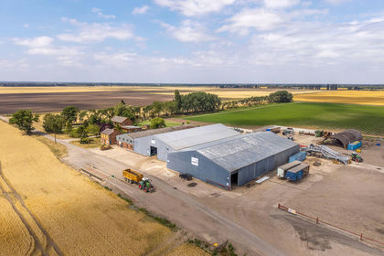
- Price
- Guide Price£15,000,000
- Size
- 1229.51 acres
Added on 08/08/2026Farm