
Achnasol Woodlands, 29.2 Acre Forest, Achnabobane, Spean Bridge
- Land size
- 9.2 acres
Key Features
- Approximately 9.2 acres (3.72 hectares) of freehold woodland.
- Located at Achnabobane, near Spean Bridge, in the spectacular Western Highlands.
- Boundaries outlined in red on the accompanying plan.
- Watercourses and pond features shown within and around the plot.
- Potential for woodland management and timber investment, subject to independent forestry assessment.
- Ideal for conservation, nature photography and informal recreation, subject to title provisions and necessary permissions.
- - Peaceful rural setting with convenient access to amenities in Spean Bridge and Fort William.
- Bid now! To avoid missing out
Description
Glen Spean Woodlands - Near Spean Bridge
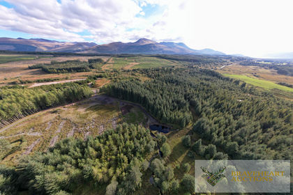
An opportunity to acquire approximately 9.2 acres of freehold woodland in the spectacular Scottish Highlands, combining a peaceful rural setting with opportunities for woodland management, conservation and recreation.
Braveheart Auctions are pleased to present Glen Spean Woodlands, Achnabobane, near Spean Bridge. Previously marketed as part of a larger woodland holding, the land is now being offered as two separate lots. Extending to approximately 37,184 square metres (3.72 hectares), with its extent outlined in red on the accompanying plan.
Set between Spean Bridge and Fort William, the woodland occupies an attractive position in Scotland's Western Highlands. The surrounding mountains, forests and lochs give the area its distinctive character, with the nearby Ben Nevis range providing a spectacular backdrop to the wider landscape.
The established woodland offers an appealing opportunity for buyers seeking a private rural holding to manage and enjoy over the longer term. Whether your interest lies in woodland conservation, habitat enhancement, nature photography or a peaceful escape into the countryside, Plot 2 provides scope to explore a range of interests, subject to the terrain, title provisions and any necessary permissions.
The accompanying plan shows watercourses crossing the plot and pond features within and around its boundary, adding to the natural character of the setting. Purchasers should refer carefully to the red outline to distinguish features included within Plot 2 from those forming part of the surrounding woodland.
The original larger holding was described as containing mature forestry. Plot 2 offers purchasers an opportunity to investigate its own timber and woodland management potential through an independent forestry assessment. Tree species, age, condition, timber volumes, harvesting suitability and extraction arrangements should be confirmed specifically for this lot. No harvesting readiness or level of timber income is guaranteed.
Beyond any potential forestry use, woodland ownership offers the opportunity to preserve and enhance natural habitats. Buyers interested in conservation may wish to explore woodland regeneration, biodiversity improvements and responsible long-term management, taking specialist advice on suitability and any available schemes. Any carbon-related project or income opportunity would require a separate assessment of eligibility.
The wider area is renowned for its wildlife and outdoor recreation. Walking, mountain biking and wildlife watching are popular throughout the surrounding Highlands, while the woodland itself may appeal to purchasers seeking space for quiet enjoyment and a closer connection with nature.
Spean Bridge provides convenient local amenities, while Fort William offers a wider range of shops, restaurants, accommodation and transport connections. This position combines a rural woodland setting with access to established Highland towns, making Plot 2 an attractive prospect for recreational buyers and those seeking a manageable woodland investment.
Tracks are shown on the accompanying plan, but purchasers should confirm legal access rights, their suitability for the intended use, and any shared maintenance obligations through the title documentation and legal pack.
Any forestry operations, groundworks, structures or changes of use will be subject to the relevant permissions and consents. Purchasers should also establish whether environmental designations affect the plot or any proposed activities. No planning permission or development potential is represented as established.
Glen Spean Woodlands offers the opportunity to own a piece of the Western Highlands - a woodland holding with natural character, a peaceful setting and scope for thoughtful long-term management.
Your own woodland retreat in the heart of the Highlands.
Be BraveÖ Follow Your Heart.
This lot will be sold under auction terms and conditions by Braveheart Auctions.
Speak to one of our dedicated team today for more information or visit our website.
Braveheart Auctions hold land and property auctions every two weeks.
Do you know someone with a property or land to sell? Speak to us about our referral programme or arrange a free, no-obligation auction valuation.
Map Location
Property details
- Tenure
- Ask Agent
- Council Tax Band
- Ask Agent
- Date Posted
- 2026-11-13
Market Value Analysis
Compared with 60 Woodland listings in Scotland (5+ acres).
Property Brochure
Seen the details? The full report adds the independent checks: planning activity, flood history, heritage and ground.
Utilities & Restrictions
Utilities
- Electricity
- Ask Agent
- Water
- Ask Agent
- Heating
- Ask Agent
- Broadband
- Ask Agent
- Sewerage
- Ask Agent
Rights & Restrictions
- Public Rights of Way
- Ask Agent
- Private Rights of Way
- Ask Agent
- Listed Property
- Ask Agent
- Restrictions
- Ask Agent
Listed status, conservation areas and planning constraints for this location are in the full report.
Property Features
- Accessibility
- Ask Agent
- Parking
- Ask Agent
- Garden
- Ask Agent
Beyond the particulars: planning activity, flood history, heritage and ground risks, checked for this exact spot.
Connectivity
Broadband
Fastest speed available at this postcode
10 Gbps
Gigabit full fibre · available to 80% of premises
Suitable for
- 4K streaming on every screen
- Full-time home working
- Online gaming & big downloads
Mobile signal
Predicted 4G and 5G signal; indoor signal depends on building materials.
Ofcom Connected Nations postcode-level predictions. Speeds and signal are modelled, not measured, and vary between addresses and providers.
Signal is the easy part. Planning activity, flood history and protected designations here are in the full report.
Nearest Schools
Primary
- Spean Bridge Primary School2.1 miles
- Pupils
- 87
- Type
- Non-denominational
- Bun-sgoil Ghaidhlig Loch Abar5.9 miles
- Pupils
- 147
- Type
- Non-denominational
- Banavie Primary School6.4 miles
- Pupils
- 91
- Type
- Non-denominational
- St Columba's RC Primary School6.4 miles
- Pupils
- 15
- Type
- Roman Catholic
- Caol Primary School6.4 miles
- Pupils
- 238
- Type
- Non-denominational
Secondary
- Lochaber High School5.5 miles
- Pupils
- 839
- Type
- Non-denominational
- Kinlochleven High School12 miles
- Pupils
- 135
- Type
- Non-denominational
- Kilchuimen Academy21 miles
- Pupils
- 47
- Type
- Non-denominational
- Ardnamurchan High School26 miles
- Pupils
- 126
- Type
- Non-denominational
- Mallaig High School34 miles
- Pupils
- 101
- Type
- Non-denominational
Distances are straight-line from the advertised location. Source: the national school registers (DfE, Welsh Government, Scottish Government) and Ofsted.
Schools are just the start: planning activity, heritage and any flood history here are in the full report.
Amenities
Supermarket
GP surgery
Pharmacy
Walking trail
Straight-line distances from the advertised location. Sources: NHS records, Geolytix supermarket locations, OS Open Greenspace and the national trails registers.
The area stacks up? Now check the location itself: planning nearby, protected designations and past flooding.
Getting Around
Nearest station
Nearest bus stop
Typical drive times
Straight-line distances from the advertised location; drive times are typical free-flow times over OpenStreetMap road data, so allow more at peak. Public transport locations from DfT NaPTAN.
Easy to reach matters. So do planning activity, flood history and ground risks: all in the full report.
Flood Risk
SEPA open data, checked around the advertised map pin for the listed acreage. Provided by LandSale, not the listing agent, and not part of the agent's particulars. Risk varies across a holding, so verify before committing.
Rivers and the sea
Surface water
Not at the pin: mapped about 60 metres away.
These bandings are the summary. Where this location sits on the flood maps, plus planning activity, heritage and ground risks, is in the full report.
Important notice: Information, maps and tags on this page are drawn from the advertising agent's marketing materials or generated automatically. LandSale has not verified them. Relying on these details is at your own risk, always carry out independent checks before committing to a purchase.
LandSale full disclaimer
Marketing information only - not formal particulars. The details on this website are provided for general guidance and do not constitute an offer or contract. Neither LandSale nor the advertising estate/land agent accepts responsibility for any inaccuracy.
1. Source of information
- Listing content: Core description, asking price, tenure, measurements, photographs and planning history originate from the marketing materials of the advertising estate or land agent. LandSale does not author this content and cannot guarantee its accuracy.
- Automated tags & categorisation: Property type, land-use class, acreage bands and similar labels may be applied by machine-learning models. They are intended as a helpful guide only and may not reflect the property's legal status or permitted use.
- Third-party & enriched data layers: Maps, boundary outlines, planning designations, soil reports, broadband coverage and other environmental or location-based insights are licensed from external suppliers. Such data are supplied “as is", may be incomplete or out of date and are subject to change without notice.
2. Verification required
Prospective purchasers must verify critical matters, including but not limited to planning permission, title boundaries, public rights of way, environmental constraints, acreage, services, access and VAT status, through their own inspections, specialist surveys, legal advisers and the selling agent before relying on the information or entering into any contract.
3. No warranty or liability
LandSale gives no warranty, express or implied, as to the accuracy, completeness or fitness for any particular purpose of the information displayed. LandSale shall not be liable for any loss, damage, cost or expense arising directly or indirectly from any use of or reliance on such information, save where liability may not be excluded by law.
4. Updates & feedback
If you believe any detail on this listing is inaccurate, please let us know. We will investigate and, where appropriate, update the listing or notify the agent.
© LandSale | Version 1.3 - August 2026
Listing agent
Braveheart Auctions Limited, Edinburgh5 South Charlotte Street, Edinburgh, Scotland, EH2 4AN
Contact Braveheart Auctions Limited, Edinburgh
5 South Charlotte Street, Edinburgh, Scotland, EH2 4AN
View agent profileSimilar properties for sale
- Price
- Guide Price£79,000
- Size
- 10.8 acres
Added on 04/11/2026Woodland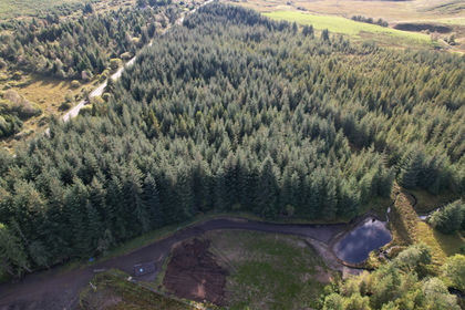
- Price
- Guide Price£90,000
- Size
- 10.8 acres
Added on 04/11/2026Woodland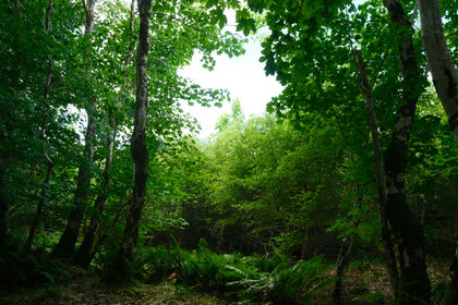
- Price
- Fixed Price£75,000
- Size
- 4.25 acres
Adhamh Wood, Oban, Argyle & Bute, , Argyll and Bute PA37 Scotland
Added on 01/10/2026Woodland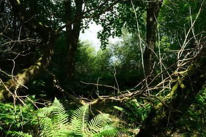
- Price
- Fixed Price£75,000
- Size
- 4 acres
Mungo Wood, Oban, Argyle & Bute, , Argyll and Bute PA37 Scotland
Added on 01/10/2026Woodland
- Price
- Fixed Price£75,000
- Size
- 5 acres
Macnab's Wood, Drumnadrochit, Highland, , Highland IV63 Scotland
Added on 28/09/2026Woodland
- Price
- Fixed Price£77,000
- Size
- 8 acres
Added on 08/10/2026Woodland
- Price
- Fixed Price£79,000
- Size
- 7.5 acres
Added on 01/10/2026Woodland
- Price
- Offers in Excess of£70,000
- Size
- 50.68 acres
Added on 18/07/2026Woodland