Dassett Road, Avon Dassett, Southam
- Land size
- 107.82 acres
Key Features
- Period Farmhouse
- 25,000 sq. ft of modern and traditional buildings
- 337.73 acres of productive arable land
- Secluded position with countryside views
- Potential for development (subject to planning)
- Lot 1 - Hill Farm, Buildings and 219 acres
- Lot 2 - 107.82 acres
- Lot 3 - 10.63 acres and a small range of traditional farm buildings
Description
Hill Farm, Avon Dassett, Lot 2 - Agricultural Land.
Extending to approximately 107.82 acres (43.63 ha)
Comprising 4 arable land parcels relatively level lying enclosed between the public highways known as The Slade and the A423.
Situation - Hill Farm is an attractive predominantly arable farm located between the villages of Avon Dassett, Fenny Compton and Farnborough within the Stratford upon Avon District of Warwickshire. The local market town of Banbury is approximately 8 miles to the south, with the town of Southam approximately 10 miles to the north, with both providing a range of local and amenity services. Warwick and Leamington Spa are also easily accessible and add to the available employment and education opportunities.
Junction 12 of the M40 is 6 miles to the North West and junction 11 is 8 miles to the south providing good midlands connectivity.
Banbury and Leamington Spa provide mainline rail stations to London and Birmingham.
The property is shown on the location plan.
Description - Hill Farm is a fully equipped arable farm comprising a traditional farmhouse with a range of traditional and modern farm buildings suitable for a variety of alternative uses (subject to planning). The farm stands in an elevated position and is conveniently located close to midlands conurbations, motorway and transport links.
The farm is being offered for sale as a whole or in up to 2 lots.
Guide Prices - Lot 1: £3.5m
Lot 2: £1.25m
As a whole £4.75m
Lot 1 (Edged Red) - Hill Farm, Buildings and 219 acres (88 Ha):
Hill Farm is approached direct from the public highway via a tree lined drive which leads gently down to reveal the house and farmyard, located centrally within the surrounding 217 acres of arable land.
The Farmhouse is a period house (Grade II Listed) with original flagstone floors to the ground floor and accommodation arranged over three floors with scope for further accommodation with internal re-configuration. Externally the property is rendered stone; pitched tile roof with a large number of period features throughout the house. The front elevation provides access to a lawned garden with landscaped borders with the rear entrance opening out onto small courtyard with outbuildings.
The property has an outdoor heated swimming pool with changing facilities and an extended patio area detached from the house.
The accommodation is shown on the floorplan and comprises:
Ground Floor:
Kitchen
Utility
Larder
Dining Room
Sitting Room
WC
External Store
First Floor:
Main Bedroom with en-suite bathroom
Bedroom 2 with washing facilities
Family Bathroom
Bedroom 3
Office
Second Floor (requires refurbishment but would provide):
Bedroom 4
Bedroom 5
Bedroom 6
Bedroom 7
There is a workshop and barn building of approximately 349 sq. ft to the west of the house within the grounds which offers additional storage space.
The house also benefits from a cellar.
Farm Buildings:
The farm buildings are shown on the numbered inset plan and the detailed plans. They extend to 25,000 sq ft (2,322 sq. m) and surround a concrete yard. Access is achieved via the driveway past the house and the agricultural buildings comprise:
1)Portal frame building with a lean-to (8,658 sq ft) under box profile sheeting with a concrete floor, part concrete panel walls on two sides.
2)Steel portal frame building (2,516 sq ft) of part concrete block part profile sheeting construction under box profile sheeting with a concrete floor and roller shutter door currently used as a farm workshop. A mezzanine is situated on the southern half of the building. A concrete panel lean-to under profile sheeting roof is adjoining the northern side of the building with an earth floor.
3)A former piggery (3,500 sq ft) of breeze block construction under profile sheeting roof.
4)General purpose building (6,477 sq ft) with wall of building 6 acting as the enclosing wall with part stone part Yorkshire boarding walls to the north and west and concrete floor under fibre cement roof.
5)Single storey stone building (881 sq ft) under fibre cement roof with concrete floor split into two, currently used for storage.
6)Stone built building (3,015 sq ft) under fibre cement roof – would be suitable for alternative uses subject to obtaining necessary planning consents.
7)In-field building (1,237 sq ft) Brick outhouse single storey brick-built building under asbestos roof previously used as a livestock shelter.
Land:
The ring fenced Lot 1 land (shown edged red), extends to 216.29 acres and comprises 7 fields of arable land with three small areas of woodland, enclosed by mature hedgerows and stockproof fencing. The land gently undulates up and down between the two containing highways to the east and west.
The land is identified as being predominantly Grade 3 on the land classification plans for England and Wales being slowly permeable seasonally wet loamy-clay soil with moderate fertility and impeded drainage suitable for pasture and combinable crops
Lot 2 (Edged Blue) - Lot 2 (shown edged blue) extends to 107.82 acres, comprising 4 arable land parcels relatively level lying enclosed between the public highways known as The Slade and the A423. Access from The Slade (a quiet gated road). The land is classified as Grade 3 and the soil described as a slowly permeable seasonally wet loamy-clay soil with moderate fertility and impeded drainage suitable for pasture and combinable crops.
Tenure & Possesion - The property will be sold freehold with vacant possession given upon completion.
A small number of the buildings are currently let out on commercial arrangements with vacant possession available on the service of a 3-month notice. Details of the rental income is available from the Agent’s Towcester office.
Rural Land Register & Environmental Schemes - The land is registered with the Rural Land Register and the fields can be transferred to the purchaser upon completion, from the vendor. The vendors will retain the historic element of previous Basic Payment Scheme claim.
The land is not currently within an SFI scheme or any other environmental management scheme.
Services - Mains water is connected to the property with drainage via a private system and mains electricity is connected.
The purchasers should make their own enquiries as to availability and adequacy of the services.
Plan, Area & Description - The property is sold as Title Numbers WK432613, WK432614, WK432607 & WK463924.
Please note field numbers quoted may not match the RPA field numbers and a plan is for identification purposes only.
The plan, area and description are believed to be correct in every way but no claim will be entertained by the vendor or the agents in respect of any error, omissions and misdescriptions.
Boundaries - Where known the boundary ownership is shown on the plan as an inward marked T on the plan.
Rights Of Way Etc. - There is a footpath running North to South and East to West across title WK432607. Neither of the footpaths are in the vicinity of the farmhouse or buildings.
Epc Rating - The property has a rating of G (1) with potential of D (63).
Council Tax - Hill Farm is within Council Tax Band F and the amount payable is £3,370.85
Local Authorities & Utility Companies - Stratford Borough Council Tel.
Western Power Tel.
Sporting, Timber & Mineral Rights - All rights are believed to be held with the freehold owner and will be included within the sale.
Method Of Sale - The property is offered for sale by private treaty and any interested party should submit their unconditional offers to the Agent’s Towcester Office.
Holdover Or Ingoing Valuation - The vendor reserves the right of holdover in respect of the growing crop if necessary or the appropriate ingoing valuation will be undertaken.
Lotting - The vendor reserves the right to offer the property for sale in any other order than that described in these particulars, subdivide, amalgamate or withdraw the property from sale without prior notice.
Fixtures & Fittings - Only those items specifically mentioned in the sales particulars are included within the sale or the items are specifically excluded.
What3words - Using the WhatThreeWords app the following will take you to the entrances of each Lot:
Lot 1: ///overdrive.sticks.messy
Lot 2: ///green.published.lucky
Lot 3: ///refrained.musically.ruins
Vendors Solicitor - Rhiannon Beswick
Arnold Thomson, 205 Watling Street West, Towcester NN12 6AX
rhiannon. Tel:01327-350666.
Viewing - Viewing is strictly by appointment by contacting Andrew Pinny or Tayla Cave on or email . Please note this is working arable farm therefore appropriate health and safety advice and bio-security measures must be taken.
Anti Money Laundering Regulations - We are required under due diligence, as set up under HRMC, to take a full identification (e.g. photo ID and recent utility bill as proof of address) of a potential purchaser prior to accepting an offer on a property.
Amc - If you would like to discuss financing a purchase of agricultural land, please speak to one of our Agricultural Mortgage Corporation, AMC agents (James Collier or Andrew Pinny) who will be happy to discuss this with you and make an introduction to AMC on your behalf.
Map Location
Property details
- Tenure
- Freehold
- Council Tax Band
- Ask Agent
- Date Posted
- 2026-11-12
Market Value Analysis
Compared with 9 Farmland & Pasture listings in West Midlands (100+ acres).
Utilities & Restrictions
Utilities
- Electricity
- Ask Agent
- Water
- Ask Agent
- Heating
- Ask Agent
- Broadband
- Ask Agent
- Sewerage
- Ask Agent
Rights & Restrictions
- Public Rights of Way
- Ask Agent
- Private Rights of Way
- Ask Agent
- Listed Property
- Ask Agent
- Restrictions
- Ask Agent
Listed status, conservation areas and planning constraints for this location are in the full report.
Property Features
- Accessibility
- Ask Agent
- Parking
- Parking Available
- Garden
- Garden
Beyond the particulars: planning activity, flood history, heritage and ground risks, checked for this exact spot.
Connectivity
Broadband
Fastest speed available at this postcode
80 Mbps
Superfast
Suitable for
- HD streaming
- Video calls
- Web & social
Mobile signal
Predicted 4G and 5G signal; indoor signal depends on building materials.
Ofcom Connected Nations postcode-level predictions. Speeds and signal are modelled, not measured, and vary between addresses and providers.
Signal is the easy part. Planning activity, flood history and protected designations here are in the full report.
Nearest Schools
Primary
- The Dassett CofE Primary School1.4 milesOfsted: Requires improvement *
- Ages
- 4 to 11
- Pupils
- 102
- Type
- Voluntary controlled school
- Faith
- Church of England
- Temple Herdewyke Primary School2.1 milesNo Ofsted rating
- Ages
- 2 to 11
- Pupils
- 107
- Type
- Academy converter
- Hornton Primary School3.3 milesOfsted: Good
- Ages
- 2 to 11
- Pupils
- 109
- Type
- Academy converter
- Cropredy Church of England Primary School4.3 milesOfsted: Requires improvement
- Ages
- 2 to 11
- Pupils
- 196
- Type
- Academy sponsor led
- Faith
- Church of England
- Kineton Church of England Primary School4.7 milesNo Ofsted rating
- Ages
- 4 to 11
- Pupils
- 208
- Type
- Academy converter
- Faith
- Church of England
Secondary
- Kineton High School4.3 milesNo Ofsted rating
- Ages
- 11 to 18
- Pupils
- 1,082
- Type
- Academy converter
- North Oxfordshire Academy5.4 milesNo Ofsted rating
- Ages
- 11 to 19
- Pupils
- 1,004
- Type
- Academy sponsor led
- Futures Institute Banbury7.2 milesNo Ofsted rating
- Ages
- 14 to 18
- Pupils
- 116
- Type
- Studio schools
- Wykham Park7.2 milesNo Ofsted rating
- Ages
- 11 to 18
- Pupils
- 800
- Type
- Academy sponsor led
- Blessed George Napier Catholic School and Sixth Form7.4 milesOfsted: Good
- Ages
- 11 to 18
- Pupils
- 943
- Type
- Academy converter
- Faith
- Roman Catholic
* Latest graded judgement covers quality of education only; no overall grade was issued under the 2024-25 inspection framework.
Distances are straight-line from the advertised location. Source: the national school registers (DfE, Welsh Government, Scottish Government) and Ofsted.
Schools are just the start: sold prices nearby, planning activity and any flood history are in the full report.
Amenities
Supermarket
GP surgery
Pharmacy
Hospital
Green space
Straight-line distances from the advertised location. Sources: NHS records, Geolytix supermarket locations, OS Open Greenspace and the national trails registers.
The area stacks up? Now check the location itself: planning nearby, protected designations and past flooding.
Getting Around
Nearest station
Nearest bus stop
Typical drive times
Straight-line distances from the advertised location; drive times are typical free-flow times over OpenStreetMap road data, so allow more at peak. Public transport locations from DfT NaPTAN.
Easy to reach matters. So do planning activity, flood history and ground risks: all in the full report.
Flood Risk
Environment Agency open data, checked around the advertised map pin for the listed acreage. Long-term risk counts flood defences; the planning map's flood zones do not. Provided by LandSale, not the listing agent, and not part of the agent's particulars. Risk varies across a holding, so verify before committing.
Rivers and the sea
Planning map: Flood Zone 1.
Surface water
Not at the pin: mapped about 60 metres away.
These bandings are the summary. Where this location sits on the flood maps, plus planning activity, heritage and ground risks, is in the full report.
Important notice: Information, maps and tags on this page are drawn from the advertising agent's marketing materials or generated automatically. LandSale has not verified them. Relying on these details is at your own risk, always carry out independent checks before committing to a purchase.
LandSale full disclaimer
Marketing information only - not formal particulars. The details on this website are provided for general guidance and do not constitute an offer or contract. Neither LandSale nor the advertising estate/land agent accepts responsibility for any inaccuracy.
1. Source of information
- Listing content: Core description, asking price, tenure, measurements, photographs and planning history originate from the marketing materials of the advertising estate or land agent. LandSale does not author this content and cannot guarantee its accuracy.
- Automated tags & categorisation: Property type, land-use class, acreage bands and similar labels may be applied by machine-learning models. They are intended as a helpful guide only and may not reflect the property's legal status or permitted use.
- Third-party & enriched data layers: Maps, boundary outlines, planning designations, soil reports, broadband coverage and other environmental or location-based insights are licensed from external suppliers. Such data are supplied “as is", may be incomplete or out of date and are subject to change without notice.
2. Verification required
Prospective purchasers must verify critical matters, including but not limited to planning permission, title boundaries, public rights of way, environmental constraints, acreage, services, access and VAT status, through their own inspections, specialist surveys, legal advisers and the selling agent before relying on the information or entering into any contract.
3. No warranty or liability
LandSale gives no warranty, express or implied, as to the accuracy, completeness or fitness for any particular purpose of the information displayed. LandSale shall not be liable for any loss, damage, cost or expense arising directly or indirectly from any use of or reliance on such information, save where liability may not be excluded by law.
4. Updates & feedback
If you believe any detail on this listing is inaccurate, please let us know. We will investigate and, where appropriate, update the listing or notify the agent.
© LandSale | Version 1.3 - August 2026
Contact Howkins & Harrison LLP, Towcester
98A Watling Street East, Towcester, NN12 6BT
View agent profileSimilar properties for sale
- Price
- Guide Price£1,200,000
- Size
- 156.74 acres
Added on 27/06/2026Farm
- Price
- Offers in Region of£980,000
- Size
- 97.65 acres
Added on 15/10/2026Farmland
- Price
- Guide Price£1,400,000
- Size
- 119.37 acres
Gorse Hill Farm, Clifton-upon-Teme WR6, Tedstone Delamere, Herefordshire, County of WR6 England
Added on 29/01/2026Farm
- Price
- Guide Price£1,175,000
- Size
- 130.17 acres
Lot 2 - Land and Buildings at Mount Pleasant Farm, Winwick, Winwick, Cambridgeshire PE28 England
Added on 24/09/2026Farmland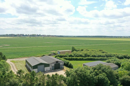
- Price
- Guide Price£1,500,000
- Size
- 135.76 acres
Added on 29/01/2026Farmland