Land at, Handford Way, Plummers Plain, West Sussex
- Land size
- 0.9 acres
Description
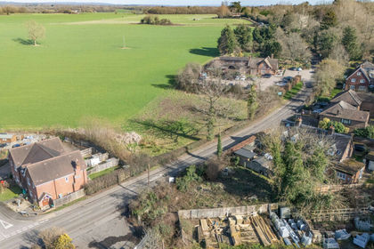
2 parcels of land for sale measuring approximately
0.9 acres* off Handford Way, accessed via a short
private road serving 5 dwellings. The land is currently
lightly wooded and will be sold with the benefit of
rights of way and utility connections to Handford Way
(private road), subject to contribution to future
maintenance costs. Handford Way forms part of a
small cluster of dwellings close to the junction of the
B2110 and Hammerpond Road. It is approximately 2
miles from Handcross Village, the M23/A23 and 6
miles to Horsham and Haywards Heath.
By way of background, the land for sale is part of the
curtilage of The Warren, a large country house built in
1895, converted into flats in 1965 and partly
belonging to the vendor of the 2 plots. The whole is
part of The Warren Estate, extending to
approximately 40 acres (until 1952 650 acres).
PLANNING
The land is adjacent to a larger parcel of land which
secured outline planning consent for residential
development in 1963, subsequent to which 5
dwellings were built and now front the made up
Handford Way. The land now for sale is currently
beyond any defined residential settlement boundary
and is classified in the Horsham District Council Local
Plan as being land in the Countryside and within the
High Weald National Landscape (AONB). As such,
land use is currently restrictive. However, the land is
situated close to this previously developed cul de sac,
characterised by individual dwellings in spacious
plots. It may therefore have some potential for
development, subject to appropriate consents. We
would direct interested persons to the recently
updated National Planning Policy Guidance 2026,
that implements the Government’s policy aimed at
boosting the supply of housing.
Note 1: The landowner is pursuing a planning
application for residential development of nearby
land. See Horsham District Council
( planning reference
DC/26/1639
LAND NEAR HANDCROSS, HORSHAM, WEST SUSSEX RH13 6PD
2 plots of land approx. 0.9 acres each with vehicular access.
GUIDE PRICE £200,000 FREEHOLD per plot
Peter Leete and Partners
The Green, Headley Road, Grayshott,
Hindhead, Surrey GU26 6LG
t:
Note 2: There is a public footpath (No 1706) leading
up from the B2110 Handcross Road which passes
diagonally between the 2 plots of land.
Note 3: Access via Handford Way would be subject to
maintenance contributions. There are no mains
services to the land. There is potential to connect to a
shared sewage system in Handford Way, subject to
maintenance contributions.
ENQUIRIES
All enquiries must be directed to the sole selling
agents, Peter Leete and Partners who will provide
instructions for nearby parking and viewing of the
plots on foot via the public footpath (1706)
SALE TERMS
Our clients are seeking offers in the region of
£200,000 for the freehold interest of each parcel of
land. In order to preserve the local amenity,
alternative use of the land will be restricted to one
residential dwelling.
The Estate is strongly motivated to assist wherever
possible, development proposals for the land in
keeping with the local architectural heritage and
unique quality of the landscape
Boundaries have not been fully demarked and will be
set out and agreed with the successful purchaser in
due course.
*Measurement provided by Seller and should be
verified
The agents, associated staff and third parties give notice that: 1. We are
not authorised to make or give any representations or
warranties in relation to the property, either on our own behalf or on
behalf of our client or otherwise. We assume no responsibility
for any statement that may be made in any sales particulars,
correspondence, verbally or otherwise. Any such statements do not form
part of any offer or contract and must not be relied upon as statements or
representations of fact. 2. Any areas, measurements or distances in sales
particulars are approximate. Any plans and floor areas are for guidance
only. 3. It should not be assumed that the property has all necessary
planning, building regulation or other consents. We have not tested any
services, equipment or facilities. 4. Purchasers must satisfy themselves
and rely on their own enquiries and surveys prior to committing to
purchase the property.
Map Location
Property details
- Tenure
- Ask Agent
- Council Tax Band
- Ask Agent
- Date Posted
- 2026-11-11
Utilities & Restrictions
Utilities
- Electricity
- Ask Agent
- Water
- Ask Agent
- Heating
- Ask Agent
- Broadband
- Ask Agent
- Sewerage
- Ask Agent
Rights & Restrictions
- Public Rights of Way
- Ask Agent
- Private Rights of Way
- Ask Agent
- Listed Property
- Ask Agent
- Restrictions
- Ask Agent
Listed status, conservation areas and planning constraints for this location are in the full report.
Property Features
- Accessibility
- Ask Agent
- Parking
- Parking Available
- Garden
- Ask Agent
Beyond the particulars: planning activity, flood history, heritage and ground risks, checked for this exact spot.
Connectivity
Broadband
Fastest speed available at this postcode
1.8 Gbps
Gigabit full fibre
Suitable for
- 4K streaming on every screen
- Full-time home working
- Online gaming & big downloads
Mobile signal
Predicted 4G and 5G signal; indoor signal depends on building materials.
Ofcom Connected Nations postcode-level predictions. Speeds and signal are modelled, not measured, and vary between addresses and providers.
Signal is the easy part. Planning activity, flood history and protected designations here are in the full report.
Nearest Schools
Primary
- Holy Trinity CofE Primary School, Lower Beeding1.5 milesOfsted: Good
- Ages
- 4 to 11
- Pupils
- 80
- Type
- Voluntary controlled school
- Faith
- Church of England
- Handcross Primary School1.7 milesNo Ofsted rating
- Ages
- 2 to 11
- Pupils
- 238
- Type
- Community school
- St. Mark's CofE Primary School2.3 milesNo Ofsted rating
- Ages
- 4 to 11
- Pupils
- 100
- Type
- Voluntary controlled school
- Faith
- Church of England
- Colgate Primary School2.6 milesNo Ofsted rating
- Ages
- 4 to 11
- Pupils
- 126
- Type
- Community school
- Heron Way Primary School3.2 milesOfsted: Outstanding
- Ages
- 4 to 11
- Pupils
- 417
- Type
- Community school
Secondary
- The Forest School3.5 milesNo Ofsted rating
- Ages
- 11 to 16
- Pupils
- 1,115
- Type
- Academy converter
- Millais School3.6 milesOfsted: Good
- Ages
- 11 to 16
- Pupils
- 896
- Type
- Community school
- Thomas Bennett Community College4.2 milesOfsted: Good
- Ages
- 11 to 18
- Pupils
- 1,261
- Type
- Academy converter
- Holy Trinity CofE Secondary School, Crawley4.3 milesOfsted: Good
- Ages
- 11 to 18
- Pupils
- 1,340
- Type
- Voluntary aided school
- Faith
- Church of England
- Bohunt Horsham4.4 milesOfsted: Good
- Ages
- 4 to 16
- Pupils
- 1,294
- Type
- Free schools
Distances are straight-line from the advertised location. Source: the national school registers (DfE, Welsh Government, Scottish Government) and Ofsted.
Schools are just the start: sold prices nearby, planning activity and any flood history are in the full report.
Amenities
Supermarket
GP surgery
Pharmacy
Hospital
Straight-line distances from the advertised location. Sources: NHS records, Geolytix supermarket locations, OS Open Greenspace and the national trails registers.
The area stacks up? Now check the location itself: planning nearby, protected designations and past flooding.
Getting Around
Nearest station
Nearest bus stop
Typical drive times
Straight-line distances from the advertised location; drive times are typical free-flow times over OpenStreetMap road data, so allow more at peak. Public transport locations from DfT NaPTAN.
Easy to reach matters. So do planning activity, flood history and ground risks: all in the full report.
Flood Risk
Environment Agency open data, checked around the advertised map pin for the listed acreage. Long-term risk counts flood defences; the planning map's flood zones do not. Provided by LandSale, not the listing agent, and not part of the agent's particulars. Risk varies across a holding, so verify before committing.
Rivers and the sea
Planning map: Flood Zone 1.
Surface water
These bandings are the summary. Where this location sits on the flood maps, plus planning activity, heritage and ground risks, is in the full report.
Important notice: Information, maps and tags on this page are drawn from the advertising agent's marketing materials or generated automatically. LandSale has not verified them. Relying on these details is at your own risk, always carry out independent checks before committing to a purchase.
LandSale full disclaimer
Marketing information only - not formal particulars. The details on this website are provided for general guidance and do not constitute an offer or contract. Neither LandSale nor the advertising estate/land agent accepts responsibility for any inaccuracy.
1. Source of information
- Listing content: Core description, asking price, tenure, measurements, photographs and planning history originate from the marketing materials of the advertising estate or land agent. LandSale does not author this content and cannot guarantee its accuracy.
- Automated tags & categorisation: Property type, land-use class, acreage bands and similar labels may be applied by machine-learning models. They are intended as a helpful guide only and may not reflect the property's legal status or permitted use.
- Third-party & enriched data layers: Maps, boundary outlines, planning designations, soil reports, broadband coverage and other environmental or location-based insights are licensed from external suppliers. Such data are supplied “as is", may be incomplete or out of date and are subject to change without notice.
2. Verification required
Prospective purchasers must verify critical matters, including but not limited to planning permission, title boundaries, public rights of way, environmental constraints, acreage, services, access and VAT status, through their own inspections, specialist surveys, legal advisers and the selling agent before relying on the information or entering into any contract.
3. No warranty or liability
LandSale gives no warranty, express or implied, as to the accuracy, completeness or fitness for any particular purpose of the information displayed. LandSale shall not be liable for any loss, damage, cost or expense arising directly or indirectly from any use of or reliance on such information, save where liability may not be excluded by law.
4. Updates & feedback
If you believe any detail on this listing is inaccurate, please let us know. We will investigate and, where appropriate, update the listing or notify the agent.
© LandSale | Version 1.3 - August 2026
Contact Peter Leete & Partners, Grayshott
The Green Headley Road, Grayshott, Hindhead, GU26 6LG
View agent profileSimilar properties for sale
- Price
- Offers in Excess of£175,000
Manor Road, Hurstpierpoint, BN6, Hurstpierpoint and Sayers Common, West Sussex BN6 England
Added on 28/02/2026Development Land
- Price
- £250,000
Added on 26/03/2026Building Plot
- Price
- Offers in Region of£185,000
90 Goldstone Villas, Hove, BN3, Hove and Portslade, Brighton and Hove BN3 England
Added on 17/07/2026Workshop Added on 30/05/2026Development Land
 Added on 29/01/2026Building Plot
- Price
- Guide Price£215,000
- Size
- 0.05 acres
The Coach House, Kenley CR8, Croydon South, Croydon CR8 England
Added on 30/07/2026Development Land
- Price
- Guide Price£250,000
- Size
- 2.7 acres
Added on 29/01/2026Development Land Added on 27/09/2026Development Land
- Price
- Guide Price£250,000
- Size
- 0.08 acres
Added on 08/08/2026Self Build Plot
- Price
- £200,000
Added on 15/08/2026Development Land