Holbeam, Ogwell, TQ12
- Land size
- 68.85 acres
Key Features
- An attractive 68.85 acres (27.86ha) of farmland
- Agricultural buildings with residential potential stpp
- Access from the North and South
- Mains water and the Kester Brook to the north
- Suited for farming, conservation or amenity uses.
- Available as a whole or up to four lots
Description
Higher Holbeam Farm extends in total to approximately 68.85 acres (27.86 hectares) and comprises predominantly productive grassland pasture, together with a farmyard and agricultural buildings.
The land has a gently undulating topography, rising and falling from north to south, and has traditionally been utilised for the grazing of livestock and the production of grass fodder, including hay and silage. The grassland is generally well drained and provides useful agricultural accommodation, suitable for a variety of farming and equestrian interests, subject to any necessary consents.
The fields are served by a mains water supply, with water distributed throughout the property via a system of field troughs. The supply is metered from a connection located in the adjoining public highway.
A central access track runs through the holding, providing convenient access to the various fields and farmyard directly from the public highway.
The property is being offered for sale by Informal Tender as four lots or as a whole or a combination of lots.
LOT 1 – Buildings & Land 13.57 acres (5.49 ha)
Lot 1 (as shown coloured red on the sales plan) extends to around 13.57 acres (5.49 ha) and includes the farmyard containing a range of agricultural buildings that provide useful accommodation for general agricultural purposes and livestock, while the property benefits from separate direct access off the the public highway through large double gates.
Of particular note is the principal agricultural barn, which was the subject of a grant of prior approval dated 21 August 2021 under Part 3, Class Q(a) and (b), and paragraph W of the Town and Country Planning (General Permitted Development) (England) Order 2015, for the change of use of the agricultural building to a dwelling.
Prospective purchasers should note that the approved development was not completed within the requisite three-year period and the prior approval has therefore lapsed.
LOT 2 – Land extending 7.45 acres (3.01 ha)
Lot 2 (as shown coloured yellow on the sales plan) extends to around 7.45 acres (3.01 ha) being a large level field with good access and shared mains water supply. The land is predominately grass pasture including an area of woodland copse of around 1.12 acres in the south west corner.
LOT 3 – Land extending 8.78 acres (3.55 ha)
Lot 3 (as shown coloured green on the sales plan) extends to around 8.78 acres (3.55 ha) being a large level field with good access over the track and shared mains water supply. The land is predominately grass pasture facing south with mature hedgerows.
LOT 4 – Land extending to 39.05 acres (15.80 ha)
Lot 4 (as shown coloured blue on the sales plan) is the largest lot and extends to around 39.05 acres (15.80 ha) consisting of a number of field parcels facing predominately north with mature hedgerow boundaries being level along the ridge to gently sloping and steep in places. the block of land is good for grazing and farming of livestock, with good access to the north and south, a shared mains water supply and river frontage to the north. The land is predominately grass pasture including an area of woodland extending to around 5.15 acres.
Method of Sale
The property is being offered for sale by Informal Tender (unless sold prior), such that buyers are invited to submit their highest and final offers in a sealed envelope by 12 noon Thursday 7th January 2027. Tender forms are available to download or on request from Rendells.
All tenders must be submitted to Rendells, 13 Market Street, Newton Abbot TQ12 2RL
The seller does not undertake to accept the highest or any of the offers and the seller reserves the right to withdraw, alter or amend the way in which the land is offered for sale.
Buyer(s) will be required to exchange contracts within six weeks of their solicitor receiving a draft contract.
Tenure
Freehold with Vacant Possession
Access
Access is directly off the public highway to the south with double gates leading directly into Lot 1 - buildings and yard area and a separate gated stoned track provides shared access into Lots 2, 3 & 4. What3Words ///hobbyists.ever.inserting
Services
All lots will that the benefit of a shared water supply that is metered. All lots shall have the right to lay services under the track accessway from the public highway. Purchasers are advised to make their own enquiries as to any other connections.
Management & Environmental
Currently the land is not under any schemes nor any management plan. The property is registered but is not receiving any payments or grants from DEFRA or the RPA.
Wayleaves, Rights & Easements
The property is sold subject to any Rights of Way, Wayleaves, Rights or Easements which exist at the time of sale whether they are mentioned in these particulars or not. Potential purchasers are advised to make their own enquiries.
Local Authority
Teignbridge District Council, Forde House, newton Abbot TQ12 4XX
Viewings
By appointment only. Call Rendells Rural Department - Newton Abbot Office
or email:
Drone Photography
A video can be viewed at click on the link
Plan
The sale plans have been prepared from the Land Registry title plans and are for identification purposes only, all would be purchasers are advised to make a thorough inspection of the property to be aware of its extent.
Health & Safety
Applicants/purchasers enter and view the property entirely at their own risk and no responsibility is accepted by the vendors or the agents for the purchasers/applicants whilst on the property.
Map Location
Property details
- Tenure
- Freehold
- Council Tax Band
- Ask Agent
- Date Posted
- 2026-11-10
Market Value Analysis
Compared with 46 Farms & Smallholdings listings in South West England (50+ acres).
Utilities & Restrictions
Utilities
- Electricity
- Ask Agent
- Water
- Mains
- Heating
- Ask Agent
- Broadband
- Ask Agent
- Sewerage
- Ask Agent
Rights & Restrictions
- Public Rights of Way
- Ask Agent
- Private Rights of Way
- Yes
- Listed Property
- Ask Agent
- Restrictions
- Ask Agent
Listed status, conservation areas and planning constraints for this location are in the full report.
Property Features
- Accessibility
- Ask Agent
- Parking
- Ask Agent
- Garden
- Garden
Beyond the particulars: planning activity, flood history, heritage and ground risks, checked for this exact spot.
Connectivity
Broadband
Fastest speed available at this postcode
8 Mbps
Under 10 Mbps here
Suitable for
- Basic browsing & email
Mobile signal
Predicted 4G and 5G signal; indoor signal depends on building materials.
Ofcom Connected Nations postcode-level predictions. Speeds and signal are modelled, not measured, and vary between addresses and providers.
Signal is the easy part. Planning activity, flood history and protected designations here are in the full report.
Nearest Schools
Primary
- Denbury Primary School1.4 milesOfsted: Good
- Ages
- 2 to 11
- Pupils
- 111
- Type
- Community school
- Bradley Barton Primary School and Nursery Unit1.5 milesNo Ofsted rating
- Ages
- 3 to 11
- Pupils
- 467
- Type
- Community school
- Canada Hill Community Primary School1.8 milesOfsted: Good
- Ages
- 4 to 11
- Pupils
- 344
- Type
- Community school
- Blackpool Church of England Primary School1.9 milesOfsted: Good
- Ages
- 4 to 11
- Pupils
- 244
- Type
- Academy converter
- Faith
- Church of England
- St Joseph's Catholic Primary School2 milesOfsted: Requires improvement
- Ages
- 5 to 11
- Pupils
- 80
- Type
- Academy converter
- Faith
- Roman Catholic
Secondary
- Coombeshead Academy2.1 milesOfsted: Good
- Ages
- 11 to 18
- Pupils
- 870
- Type
- Academy converter
- Newton Abbot College2.2 milesOfsted: Good *
- Ages
- 11 to 18
- Pupils
- 1,108
- Type
- Academy converter
- South Devon UTC2.6 milesOfsted report card · Feb 2026
- Ages
- 14 to 19
- Pupils
- 184
- Type
- University technical college
- Teign School3.3 milesOfsted: Good
- Ages
- 11 to 18
- Pupils
- 1,111
- Type
- Academy converter
- South Dartmoor Community College3.6 milesOfsted: Good *
- Ages
- 11 to 18
- Pupils
- 801
- Type
- Academy converter
* Latest graded judgement covers quality of education only; no overall grade was issued under the 2024-25 inspection framework.
Distances are straight-line from the advertised location. Source: the national school registers (DfE, Welsh Government, Scottish Government) and Ofsted.
Schools are just the start: sold prices nearby, planning activity and any flood history are in the full report.
Amenities
Supermarket
GP surgery
Pharmacy
Hospital
Green space
Straight-line distances from the advertised location. Sources: NHS records, Geolytix supermarket locations, OS Open Greenspace and the national trails registers.
The area stacks up? Now check the location itself: planning nearby, protected designations and past flooding.
Getting Around
Nearest station
Nearest bus stop
Typical drive times
Straight-line distances from the advertised location; drive times are typical free-flow times over OpenStreetMap road data, so allow more at peak. Public transport locations from DfT NaPTAN.
Easy to reach matters. So do planning activity, flood history and ground risks: all in the full report.
Flood Risk
Environment Agency open data, checked around the advertised map pin for the listed acreage. Long-term risk counts flood defences; the planning map's flood zones do not. Provided by LandSale, not the listing agent, and not part of the agent's particulars. Risk varies across a holding, so verify before committing.
Rivers and the sea
Planning map: Flood Zone 1.
Surface water
Not at the pin: mapped about 280 metres away.
These bandings are the summary. Where this location sits on the flood maps, plus planning activity, heritage and ground risks, is in the full report.
Important notice: Information, maps and tags on this page are drawn from the advertising agent's marketing materials or generated automatically. LandSale has not verified them. Relying on these details is at your own risk, always carry out independent checks before committing to a purchase.
LandSale full disclaimer
Marketing information only - not formal particulars. The details on this website are provided for general guidance and do not constitute an offer or contract. Neither LandSale nor the advertising estate/land agent accepts responsibility for any inaccuracy.
1. Source of information
- Listing content: Core description, asking price, tenure, measurements, photographs and planning history originate from the marketing materials of the advertising estate or land agent. LandSale does not author this content and cannot guarantee its accuracy.
- Automated tags & categorisation: Property type, land-use class, acreage bands and similar labels may be applied by machine-learning models. They are intended as a helpful guide only and may not reflect the property's legal status or permitted use.
- Third-party & enriched data layers: Maps, boundary outlines, planning designations, soil reports, broadband coverage and other environmental or location-based insights are licensed from external suppliers. Such data are supplied “as is", may be incomplete or out of date and are subject to change without notice.
2. Verification required
Prospective purchasers must verify critical matters, including but not limited to planning permission, title boundaries, public rights of way, environmental constraints, acreage, services, access and VAT status, through their own inspections, specialist surveys, legal advisers and the selling agent before relying on the information or entering into any contract.
3. No warranty or liability
LandSale gives no warranty, express or implied, as to the accuracy, completeness or fitness for any particular purpose of the information displayed. LandSale shall not be liable for any loss, damage, cost or expense arising directly or indirectly from any use of or reliance on such information, save where liability may not be excluded by law.
4. Updates & feedback
If you believe any detail on this listing is inaccurate, please let us know. We will investigate and, where appropriate, update the listing or notify the agent.
© LandSale | Version 1.3 - August 2026
Similar properties for sale
- Price
- Guide Price£750,000
- Size
- 163.06 acres
Sidmouth Woods, Sidmouth, EX10, Sidmouth, Devon EX10 England
Added on 24/07/2026Woodland
- Price
- Guide Price£600,000
- Size
- 19.11 acres
Stowford Park, East Putford, EX22, Bulkworthy, Devon EX22 England
Added on 02/10/2026Development Land
- Price
- Offers in Region of£675,000
- Size
- 13.6 acres
Added on 09/07/2026Building Plot
- Price
- Offers in Region of£600,000
- Size
- 1.21 acres
Land at Combe Street Lane, Yeovil, BA21, Yeovil Without, Somerset BA21 England
Added on 29/01/2026Development Land
- Price
- Guide Price£700,000
- Size
- 2.07 acres
Added on 29/01/2026Development Land
- Price
- POA
- Size
- 1.65 acres
Land at Whitstone Hill, Pilton, Shepton Mallet, Somerset, Pilton, Somerset BA4 England
Added on 23/09/2026Development Land
- Price
- Guide Price£950,000
- Size
- 120.79 acres
Added on 15/10/2026Agricultural Land
- Price
- Guide Price£675,000
- Size
- 44.1 acres
Llwyn-y-Celyn Farm Lot 3, Shirenewton, Chepstow, NP16, Chepstow, Monmouthshire NP16 Wales
Added on 29/01/2026Agricultural Land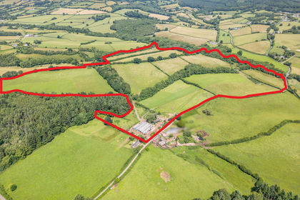
- Price
- Guide Price£1,100,000
- Size
- 97.25 acres
Llwyn-y-Celyn Farm Lot 2, Shirenewton, Chepstow, NP16, Chepstow, Monmouthshire NP16 Wales
Added on 29/01/2026Dairy Farm
- Price
- Guide Price£600,000
- Size
- 0.91 acres
The Paddock, Marshfied, Marshfield, South Gloucestershire SN14 England
Added on 17/09/2026Pasture