Clivey, Dilton Marsh, Westbury
- Land size
- 1.84 acres
- Bedrooms
- 4
- Bathrooms
- 3
Key Features
- Approximately 1.84 acres of level grazing land.
- Full planning permission granted under reference 09/00941/FUL (Wiltshire Council).
- Pre-commencement conditions discharged and initial building control foundation inspections registered.
- Direct access from the B3099 Clivey via a recessed field gate entrance with a tarmacadam crossover.
Description
A prime development opportunity comprising a 1.84-acre parcel of grazing land with the benefit of planning permission for an agricultural worker's dwelling.
Proposed Accommodation (As Per Approved Plans) - Ground Floor
• Entrance Hall: Central welcoming hallway.
• Lounge & Study: Dual front-facing reception spaces.
• Dining Room: Separate formal dining space adjoining the kitchen.
• Kitchen: Rear-facing kitchen layout with direct access to utility.
• Utility & W.C.: Functional boot/utility room with a ground-floor toilet and secondary external access.
• Garage: Attached single garage ((30'6'' times 23')) with an internal access door.
First Floor
• Principal Bedroom: Large double bedroom featuring a dedicated dressing area and an en-suite bathroom.
• Three Further Bedrooms: Well-proportioned bedrooms arranged around a central landing.
• Family Bathroom: Main shared bathroom suite
Grounds & Services - Driveway: Planned bound-gravel driveway with a sweeping turning circle providing ample off-road parking.
Drainage: Approved scheme for an independent septic tank and herringbone drainage field.
Landscaping: Bound by native species hedgerows (including Blackthorn, Hawthorn, and Dog Rose) alongside a 7m high coniferous boundary screen
Agent's Notes - Planning Conditions
The property carries a specialised agricultural occupancy restriction under planning reference 09/00941/FUL. Occupation of the dwelling is strictly limited to a person solely or mainly employed, or last employed, in the locality in agriculture (as defined in Section 336 of the Town and Country Planning Act 1990) or in forestry, including any dependents of such a person residing with him or her.
Commencement of Development
Prospective purchasers should note that pre-commencement planning conditions have been formally discharged by Wiltshire Council, and building control applications are registered (Ref: BR/W/13/0483/DOMBN). Initial foundation inspections have been recorded, effectively safeguarding the permanence of the planning permission.
Services
While the approved plans grant provisions for an independent private septic tank and surface water soakaways, buyers must satisfy themselves as to the exact location, capacity, and connection costs for mains water and electricity infrastructure running alongside the B3099 Clivey.
Boundaries & Fencing
The purchaser will be responsible for erecting and maintaining a stockproof fence along the newly defined boundaries, as well as planting the native hedgerow species scheme (to include Blackthorn, Hawthorn, and Dog Rose) in accordance with the approved landscaping plans.
Rights of Way & Easements
The land is sold subject to and with the benefit of all existing rights of way, wayleaves, and easements, whether public or private, specifically including the shared visibility splays and crossover access off the B3099.
Transport & Connectivity - Despite its peaceful, semi-rural setting, the location offers highly efficient regional transport links:
Rail Links:
Dilton Marsh Rail Station is within comfortable walking distance (approx. 9 minutes / 0.4 miles via the High Street). Operated by Great Western Railway, it provides direct connecting lines toward Cardiff Central, Bristol, and Southampton. Westbury Railway Station sits just 2.5 miles to the northeast. As a major regional rail hub, it provides fast, direct main-line services straight to London Paddington (approx. 1 hour 20 minutes).
Road Network:
The B3099 links swiftly to the A36 (for Bath and Salisbury) and the A350 corridor, giving straightforward vehicle access to the M4 motorway network.
Schooling & Education - The plot is ideally positioned within a short distance of several highly regarded local educational institutions.
Primary Education:
Dilton Marsh C of E Primary School is located under a 10-minute walk (approx. 0.5 miles) away, offering an accessible, village-centric option for younger families. Westbury Leigh C of E Primary School and Bitham Brook Primary School are both located less than a 5-minute drive away in neighbouring Westbury.
Secondary Education:
Matravers School in Westbury is the closest secondary provider (approx. 4-minute drive), serving children aged 11–18 and featuring a dedicated Sixth Form.
Specialist Further Education:
Fairfield College is situated practically on the doorstep (approx. 4-minute walk), providing specialized day and residential courses for young adults.
Map Location
Property details
- Tenure
- Freehold
- Council Tax Band
- Ask Agent
- Date Posted
- 2026-11-09
Market Value Analysis
Compared with 47 Building Plots listings in South West England (1+ acres).
Utilities & Restrictions
Utilities
- Electricity
- Ask Agent
- Water
- Ask Agent
- Heating
- Ask Agent
- Broadband
- Ask Agent
- Sewerage
- Ask Agent
Rights & Restrictions
- Public Rights of Way
- Ask Agent
- Private Rights of Way
- Ask Agent
- Listed Property
- Ask Agent
- Restrictions
- Ask Agent
Listed status, conservation areas and planning constraints for this location are in the full report.
Property Features
- Accessibility
- Ask Agent
- Parking
- Parking Available
- Garden
- Garden
Beyond the particulars: planning activity, flood history, heritage and ground risks, checked for this exact spot.
Connectivity
Broadband
Fastest speed available at this postcode
1 Gbps
Gigabit full fibre · available to 75% of premises
Suitable for
- 4K streaming on every screen
- Full-time home working
- Online gaming & big downloads
Mobile signal
Predicted 4G and 5G signal; indoor signal depends on building materials.
Ofcom Connected Nations postcode-level predictions. Speeds and signal are modelled, not measured, and vary between addresses and providers.
Signal is the easy part. Planning activity, flood history and protected designations here are in the full report.
Nearest Schools
Primary
- Dilton Marsh CofE Primary School818 metresOfsted: Good
- Ages
- 4 to 11
- Pupils
- 158
- Type
- Academy converter
- Faith
- Church of England
- Westbury Leigh CofE Primary School1.2 milesOfsted: Requires improvement
- Ages
- 4 to 11
- Pupils
- 240
- Type
- Academy sponsor led
- Faith
- Church of England
- Chapmanslade Church of England Primary School1.6 milesOfsted: Good
- Ages
- 4 to 11
- Pupils
- 99
- Type
- Academy converter
- Faith
- Church of England
- Westbury Church of England Junior School1.7 milesOfsted: Requires improvement
- Ages
- 7 to 11
- Pupils
- 226
- Type
- Voluntary controlled school
- Faith
- Church of England
- Westbury Infant School1.8 milesNo Ofsted rating
- Ages
- 4 to 7
- Pupils
- 189
- Type
- Community school
Secondary
- Matravers School1.8 milesOfsted: Good
- Ages
- 11 to 18
- Pupils
- 958
- Type
- Foundation school
- Selwood Academy3.4 milesOfsted: Good
- Ages
- 9 to 13
- Pupils
- 658
- Type
- Academy converter
- Faith
- Church of England/Methodist
- Frome Community College3.6 milesNo Ofsted rating
- Ages
- 13 to 18
- Pupils
- 1,298
- Type
- Academy converter
- Kingdown School4.3 milesNo Ofsted rating
- Ages
- 11 to 18
- Pupils
- 1,347
- Type
- Academy converter
- The Clarendon Academy4.4 milesNo Ofsted rating
- Ages
- 11 to 18
- Pupils
- 1,082
- Type
- Academy sponsor led
Distances are straight-line from the advertised location. Source: the national school registers (DfE, Welsh Government, Scottish Government) and Ofsted.
Schools are just the start: sold prices nearby, planning activity and any flood history are in the full report.
Amenities
Supermarket
GP surgery
Pharmacy
Hospital
Green space
Straight-line distances from the advertised location. Sources: NHS records, Geolytix supermarket locations, OS Open Greenspace and the national trails registers.
The area stacks up? Now check the location itself: planning nearby, protected designations and past flooding.
Getting Around
Nearest station
Nearest bus stop
Typical drive times
Straight-line distances from the advertised location; drive times are typical free-flow times over OpenStreetMap road data, so allow more at peak. Public transport locations from DfT NaPTAN.
Easy to reach matters. So do planning activity, flood history and ground risks: all in the full report.
Flood Risk
Environment Agency open data, checked around the advertised map pin for the listed acreage. Long-term risk counts flood defences; the planning map's flood zones do not. The map pin for this listing is approximate, so these readings describe the surrounding area. Provided by LandSale, not the listing agent, and not part of the agent's particulars. Risk varies across a holding, so verify before committing.
Rivers and the sea
Planning map: Flood Zone 1.
Surface water
Not at the pin: mapped about 40 metres away.
These bandings are the summary. Where this location sits on the flood maps, plus planning activity, heritage and ground risks, is in the full report.
Important notice: Information, maps and tags on this page are drawn from the advertising agent's marketing materials or generated automatically. LandSale has not verified them. Relying on these details is at your own risk, always carry out independent checks before committing to a purchase.
LandSale full disclaimer
Marketing information only - not formal particulars. The details on this website are provided for general guidance and do not constitute an offer or contract. Neither LandSale nor the advertising estate/land agent accepts responsibility for any inaccuracy.
1. Source of information
- Listing content: Core description, asking price, tenure, measurements, photographs and planning history originate from the marketing materials of the advertising estate or land agent. LandSale does not author this content and cannot guarantee its accuracy.
- Automated tags & categorisation: Property type, land-use class, acreage bands and similar labels may be applied by machine-learning models. They are intended as a helpful guide only and may not reflect the property's legal status or permitted use.
- Third-party & enriched data layers: Maps, boundary outlines, planning designations, soil reports, broadband coverage and other environmental or location-based insights are licensed from external suppliers. Such data are supplied “as is", may be incomplete or out of date and are subject to change without notice.
2. Verification required
Prospective purchasers must verify critical matters, including but not limited to planning permission, title boundaries, public rights of way, environmental constraints, acreage, services, access and VAT status, through their own inspections, specialist surveys, legal advisers and the selling agent before relying on the information or entering into any contract.
3. No warranty or liability
LandSale gives no warranty, express or implied, as to the accuracy, completeness or fitness for any particular purpose of the information displayed. LandSale shall not be liable for any loss, damage, cost or expense arising directly or indirectly from any use of or reliance on such information, save where liability may not be excluded by law.
4. Updates & feedback
If you believe any detail on this listing is inaccurate, please let us know. We will investigate and, where appropriate, update the listing or notify the agent.
© LandSale | Version 1.3 - August 2026
Contact Symonds & Sampson, Devizes
Unit 1, The Grain Manor Farm Yard, Coate, Devizes, SN10 3LP
View agent profileSimilar properties for sale
- Price
- Guide Price£95,000
Added on 02/11/2026Building Plot
- Price
- Guide Price£140,000
- Size
- 0.2 acres
Building Plot, 188 St Ediths Marsh, Bromham, Chippenham, SN15, Bromham, Wiltshire SN15 England
Added on 15/10/2026Building Plot
- Price
- £100,000
Land at Rear of Bear Inn, 12 Market Place, Wincanton, Somerset, BA9, Wincanton, Somerset BA9 England
Added on 17/07/2026Development Land
- Price
- Guide Price£150,000
- Size
- 0.27 acres
BUILDING PLOT - Tower Road South, Warmley, Bristol, Oldland, South Gloucestershire BS30 England
Added on 20/10/2026Building Plot
- Price
- Guide Price£125,000
Added on 20/10/2026Building Plot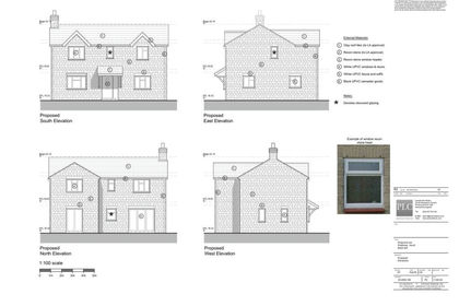
- Price
- Guide Price£115,000
Podimore, Yeovil, BA22, Yeovilton and District, Somerset BA22 England
Added on 11/03/2026Building Plot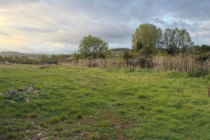
- Price
- Guide Price£150,000
- Size
- 0.27 acres
Building Plot, Peak Lane, Compton Dundon, TA11, Compton Dundon, Somerset TA11 England
Added on 20/10/2026Building Plot
- Price
- Guide Price£100,000
Trevelyan Walk, Bristol, Somerset, BS10, Bristol North West, Bristol, City of BS10 England
Added on 13/10/2026Building Plot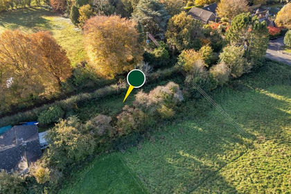
- Price
- Guide Price£95,000
- Size
- 0.21 acres
West of Parkwood, Milton Abbas, Milton Abbas, Dorset DT11 England
Added on 04/11/2026Building Plot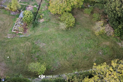 Added on 06/11/2026Self Build Plot