Hollywater Road, Passfield, Liphook, Hampshire, GU30
- Land size
- 2.25 acres
- Bedrooms
- 4
- Bathrooms
- 4
Key Features
- 3,375 sq ft plus garaging
- 4 Reception Rooms
- 4 Double Bedrooms
- 4 Bath/Shower Rooms
- Double garage and mower store
- Beloved family home for nearly 40 years
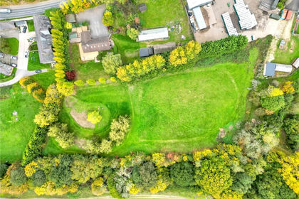
- Formal grounds of approx 1.45 acres plus paddock of approx 0.8 acres (c.2.25 acres)
- Idyllic setting nestled between National Trust woodland and paddocks
Description
Rarely available rural position; with a spring fed pond and garden plus paddock skirting National Trust woodland. Flexible and versatile family accommodation.
Entering the driveway through mature hedging there is off road parking and turning for several vehicles, plus a detached double garage with twin up and over doors and storage above.
A formal entrance porch opens through an attractive wooden front door into a wide and spacious entrance hall; plenty of room to welcome guests and family, a central hub linking all your principle rooms, and there is a great choice of reception space! Extending across the rear of the house is a large formal drawing room with feature fireplace (Jetmaster fire) flanked by built in cupboard and shelving, a large box bay window overlooking south facing gardens and patio doors opening onto a pergola covered patio. Internal double doors open to a dual aspect sitting room with attractive brick fireplace (also with a Jetmaster fire) and alcove shelving.
To the front aspect are a formal dining room and a large open plan kitchen/dining/family room. There is plenty of space for a large family breakfast table in addition to a range of cupboard storage including a large island with sink and breakfast bar. An oil powered Aga creates the rural family vibe, you can imagine baked bread, fantastic roasts with a dog warming itself in front! For practical purposes there is also a built in electric oven. Off the kitchen is a final reception room; currently used as a study (with fitted furniture ) but also a potential play room or snug, and a utility room with further door to a boot room; very practical with paddocks and woodland walks on your doorstep. Completing the ground floor accommodation is a WC.
Moving to the first floor there are four fantastic double bedrooms. Worthy of mention is the 27'10 wide master bedroom with dressing area and wardrobes, 3 south facing windows which enjoy views over the gardens, fitted air conditioning unit and en suite with both bath and shower. Front aspect double bedroom with built in wardrobes and en suite bathroom. The third bedroom is a double approached via a nursery/study/dressing room which combined extend some 25 feet; a very flexible bedroom space which also enjoys an en suite shower room. Finally, bedroom four enjoys a double aspect and benefits from being adjacent to the family bathroom which it can enjoy almost exclusively as the other bedrooms all have en suite facilities.
The gardens and grounds are special, enhanced by their south facing aspect. Adjacent to the house is a large sunny patio, which the current owners have enhanced by creating a large pergola, covered with an ornamental vine, to provide dappled shade. Beyond that are mature well established gardens, predominantly lawned with a super spring fed wildlife pond, and well established Oaks amongst other mature and established trees, rhododendrons and shrubs. Adjacent to the formal grounds is a field/paddock. The grounds have provided a super backdrop to the current owners family life, with plenty of space for children to explore, create dens and rafts, all the while being emersed in nature with plenty of visiting wildlife.
Tenure: Freehold
EPC Rating: D
Council Tax Band: G (Correct at time of publication and is subject to change following a council revaluation after a sale)
Services: The property has mains water, electricity, oil fired central heating to radiators (gas not available) and private drainage (sewage treatment plant).
Broadband and Mobile services: Visit checker.ofcom.org.uk The vendor informs us that fast broadband is available.
Special Note: : Part of the lower garden is in a flood zone, but the house has never been reached.
Location: Nine Oaks sits on the rural edge of the small hamlets of Passfield, Hollywater and Standford.
It sits well back from the road, passing over National Trust land to front. National Trust woodland also abuts the property to the side and rear creating a private rural position.
Facilities are available in Liphook and Bordon, both less than 3 miles away. Liphook offers a wide range of independent shops, cafes, restaurants and pubs in addition to a large Sainsburys supermarket and The Living Room Cinema. There is a railway station offering a stopping service into London. Golf and Leisure facilities are available close by at Griggs Green, whilst the towns of Haslemere and Petersfield are within a short drive offering a greater range of facilities and faster train services.
Bordon has undergone a massive transformation in the last ten years (the Army leaving in 2015) and offers a range of shopping and leisure facilities including a new leisure centre and The Shed leisure venue. Hogmoor Inclosure is ideal for walking, playing, enjoying a coffee in the cafe or partaking in a Park Run.
The Forest Centre sits close to Bordon High Street offering a range of shops (Chemist, B & M, Lidl, post office), a gym (Anytime Fitness), a café, community centre and the local Library). There are a good number of local shops and facilities beyond The Forest Centre including Tesco, a range of smaller independent shops and restaurants and Country Market garden centre and farm shop. There are a number of doctors surgeries including The Chase community hospital.
For families, the property is well-situated with excellent state and private schools nearby, including 3 primary schools within 2 miles, plus Liphook Infants and Juniors. Oakmoor, Woolmer Hill and Bohunt Secondary Schools are easily commutable. As are the private schools of Amesbury, Highfield and Brookham.
Map Location
Property details
- Tenure
- Freehold
- Council Tax Band
- G
- Date Posted
- 2026-11-05
Market Value Analysis
Compared with 1,592 Homes with Land listings in South East England (1+ acres).
Energy Performance Certificate
Energy Efficiency Rating
Based on UK Energy Performance Certificate standards (EU Directive 2002/91/EC)
Running costs are one side. Planning activity, flood history and ground risks for this location are in the full report.
Utilities & Restrictions
Utilities
- Electricity
- Ask Agent
- Water
- Ask Agent
- Heating
- Ask Agent
- Broadband
- Ask Agent
- Sewerage
- Ask Agent
Rights & Restrictions
- Public Rights of Way
- Ask Agent
- Private Rights of Way
- Ask Agent
- Listed Property
- Ask Agent
- Restrictions
- Ask Agent
Listed status, conservation areas and planning constraints for this location are in the full report.
Property Features
- Accessibility
- Ask Agent
- Parking
- Parking Available
- Garden
- Garden
Beyond the particulars: planning activity, flood history, heritage and ground risks, checked for this exact spot.
Connectivity
Broadband
Fastest speed available at this postcode
1.8 Gbps
Gigabit full fibre · available to 17% of premises
Suitable for
- 4K streaming on every screen
- Full-time home working
- Online gaming & big downloads
Mobile signal
Predicted 4G and 5G signal; indoor signal depends on building materials.
Ofcom Connected Nations postcode-level predictions. Speeds and signal are modelled, not measured, and vary between addresses and providers.
Signal is the easy part. Planning activity, flood history and protected designations here are in the full report.
Nearest Schools
Primary
- Woodlea Primary School947 metresOfsted: Inadequate
- Ages
- 4 to 11
- Pupils
- 184
- Type
- Academy sponsor led
- Weyford Nursery and Primary Academy1.3 milesOfsted report card · Mar 2026
- Ages
- 2 to 11
- Pupils
- 402
- Type
- Academy converter
- St Matthew's Church of England Aided Primary School1.5 milesOfsted: Good
- Ages
- 4 to 11
- Pupils
- 208
- Type
- Voluntary aided school
- Faith
- Church of England
- Bordon Infant School1.5 milesNo Ofsted rating
- Ages
- 4 to 7
- Pupils
- 266
- Type
- Academy converter
- Bordon Junior School1.6 milesOfsted: Good
- Ages
- 7 to 11
- Pupils
- 253
- Type
- Academy converter
Secondary
- Oakmoor School1.1 milesOfsted report card · Jan 2026
- Ages
- 11 to 16
- Pupils
- 912
- Type
- Academy sponsor led
- Bohunt School2.2 milesOfsted: Good
- Ages
- 11 to 18
- Pupils
- 2,012
- Type
- Academy converter
- Woolmer Hill School4.4 milesNo Ofsted rating
- Ages
- 11 to 16
- Pupils
- 892
- Type
- Academy converter
- Eggar's School6.5 milesNo Ofsted rating
- Ages
- 11 to 16
- Pupils
- 744
- Type
- Academy converter
- Amery Hill School6.8 milesNo Ofsted rating
- Ages
- 11 to 16
- Pupils
- 982
- Type
- Academy converter
Distances are straight-line from the advertised location. Source: the national school registers (DfE, Welsh Government, Scottish Government) and Ofsted.
Schools are just the start: sold prices nearby, planning activity and any flood history are in the full report.
Amenities
Supermarket
GP surgery
Pharmacy
Hospital
Straight-line distances from the advertised location. Sources: NHS records, Geolytix supermarket locations, OS Open Greenspace and the national trails registers.
The area stacks up? Now check the location itself: planning nearby, protected designations and past flooding.
Getting Around
Nearest station
Nearest bus stop
Typical drive times
Straight-line distances from the advertised location; drive times are typical free-flow times over OpenStreetMap road data, so allow more at peak. Public transport locations from DfT NaPTAN.
Easy to reach matters. So do planning activity, flood history and ground risks: all in the full report.
Flood Risk
Environment Agency open data, checked around the advertised map pin for the listed acreage. Long-term risk counts flood defences; the planning map's flood zones do not. Provided by LandSale, not the listing agent, and not part of the agent's particulars. Risk varies across a holding, so verify before committing.
Rivers and the sea
Not at the pin: mapped about 40 metres away.
Planning map: Flood Zone 3, about 20 metres away.
Surface water
Not at the pin: mapped about 50 metres away.
These bandings are the summary. Where this location sits on the flood maps, plus planning activity, heritage and ground risks, is in the full report.
Important notice: Information, maps and tags on this page are drawn from the advertising agent's marketing materials or generated automatically. LandSale has not verified them. Relying on these details is at your own risk, always carry out independent checks before committing to a purchase.
LandSale full disclaimer
Marketing information only - not formal particulars. The details on this website are provided for general guidance and do not constitute an offer or contract. Neither LandSale nor the advertising estate/land agent accepts responsibility for any inaccuracy.
1. Source of information
- Listing content: Core description, asking price, tenure, measurements, photographs and planning history originate from the marketing materials of the advertising estate or land agent. LandSale does not author this content and cannot guarantee its accuracy.
- Automated tags & categorisation: Property type, land-use class, acreage bands and similar labels may be applied by machine-learning models. They are intended as a helpful guide only and may not reflect the property's legal status or permitted use.
- Third-party & enriched data layers: Maps, boundary outlines, planning designations, soil reports, broadband coverage and other environmental or location-based insights are licensed from external suppliers. Such data are supplied “as is", may be incomplete or out of date and are subject to change without notice.
2. Verification required
Prospective purchasers must verify critical matters, including but not limited to planning permission, title boundaries, public rights of way, environmental constraints, acreage, services, access and VAT status, through their own inspections, specialist surveys, legal advisers and the selling agent before relying on the information or entering into any contract.
3. No warranty or liability
LandSale gives no warranty, express or implied, as to the accuracy, completeness or fitness for any particular purpose of the information displayed. LandSale shall not be liable for any loss, damage, cost or expense arising directly or indirectly from any use of or reliance on such information, save where liability may not be excluded by law.
4. Updates & feedback
If you believe any detail on this listing is inaccurate, please let us know. We will investigate and, where appropriate, update the listing or notify the agent.
© LandSale | Version 1.3 - August 2026
Similar properties for sale
- Price
- Offers in Region of£1,200,000
- Size
- 4 acres
Added on 18/09/2026House with Land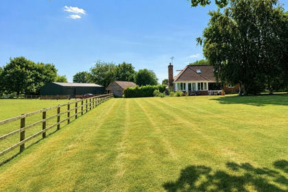
- Price
- Offers Over£1,500,000
- Size
- 10 acres
Duckmead Lane, Liss, Hampshire, Liss, Hampshire GU33 England
Added on 29/01/2026Equestrian property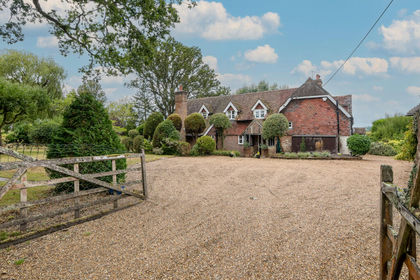
- Price
- £1,450,000
- Size
- 6.17 acres
Kites, Cradle Lane, Frith End, Bordon, Hampshire, Binsted, Hampshire GU35 England
Added on 24/09/2026House with Land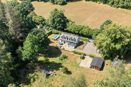
- Price
- Offers in Excess of£1,250,000
- Size
- 1.2 acres
Sandy Lane, Haslemere, Hampshire, GU27, Bramshott and Liphook, Hampshire GU27 England
Added on 04/09/2026House with Land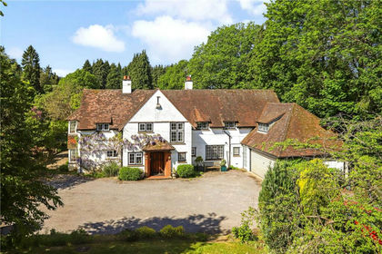
- Price
- Guide Price£1,495,000
- Size
- 1.25 acres
Added on 12/06/2026House with Land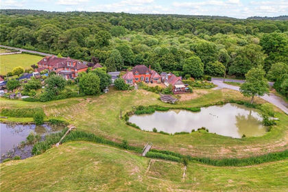
- Price
- Offers in Excess of£1,250,000
- Size
- 4.2 acres
Added on 12/06/2026House with Land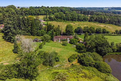
- Price
- Guide Price£1,250,000
- Size
- 3 acres
Added on 03/10/2026House with Land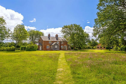
- Price
- Guide Price£1,150,000
- Size
- 1 acres
Added on 22/06/2026House with Land
- Price
- Guide Price£1,500,000
- Size
- 1.86 acres
Added on 27/10/2026Equestrian property
- Price
- Guide Price£1,200,000
- Size
- 1.6 acres
Sandy Lane, Rushmoor, Farnham, Surrey, GU10, Frensham, Surrey GU10 England
Added on 22/09/2026House with Land