The Falcon, 10 Market Hill, Huntingdon, PE29
- Land size
- 0.19 acres
Key Features
- The Falcon occupies a prominent position fronting Market Hill in the centre of the market town of Huntingdon
- A circa 16th century, Grade II-listed, mid-terraced public house incorporating a coaching archway and retaining a number of period features
- Let to a multiple pub operator (Olde England Ltd) that has been in occupation since 2014
- Occupied under a circa 19 year free of tie FRI lease, expiring on 21st March 2034
- Current passing rent of £52,500 per annum
- The guide price reflects an attractive net initial yield of 10%
Description
Location
Huntingdon is a market town in the Huntingdonshire district of Cambridgeshire, with a population of approximately 25,000 residents. It is located around 20 miles north-west of Cambridge and 22 miles south of Peterborough.
The Falcon occupies a prominent position in the heart of the town centre, fronting Market Hill, which adjoins the High Street, an established thoroughfare. The subject property is situated adjacent to the Town Hall and All Saints' Church.
The surrounding area comprises a mix of retail premises and a number of pubs and restaurants including the Market Inn, The George, Olmo Lounge, Pizza Express and Hill Ephesus Restaurant, amongst various others.
Property Description
The Falcon is a circa 16th century two storey mid terraced Grade II listed property, made of part timber framed, part plastered and part brick construction, with later extensions to the rear. It has a narrow frontage but extends out to the rear and has a well-presented trade garden.
The subject premises present well externally and contribute positively to the historic character of the surrounding streetscape.
Accommodation
The ground floor comprises of various interlinking trading areas that can accommodate around 60 covers and a large central servery. They are furnished and decorated in a traditional style throughout and benefit from retained period features, including exposed beams and log-burning/open fires.
Ancillary areas include customer WC's, beer store, basement cellar, good sized catering kitchen (at first floor) and a number of storage areas.
The first floor comprises of three additional trading areas which can accommodate a total of around 48 covers plus two pool tables and two darts boards.
The second floor consists of a double bedroom and there is a small shower room and WC located on the first floor.
Externally, the property benefits from a rear trade garden providing approximately 90 covers, part of which is covered. A further 50 covers are provided within the enclosed area behind the gated front entrance, extending towards the rear trade garden. In addition, there is a rear yard with vehicular access, a brick-built store to the rear and various ancillary storage areas.
The property's building footprint is around 1,949 sq ft and it sits on a plot size amounting to around 0.19 of an acre. Source: Nimbus Maps.
Tenure Comments
The property is held freehold (Title Number CB160908).
The property is let on a circa 19 year free of tie FRI lease to Olde England Ltd (Company Number 07568117) - (Surety: Paul Anthony Charles Hepworth) expiring on 21st March 2034 at a current rent of £52,500 per annum. There is a fixed uplift in rent to £55,000 per annum from 2nd December 2029, until lease expiry.
Guide Price
We are instructed to market the property with a guide price of £499,950 plus VAT (10% NIY) assuming purchaser's costs of 4.70%.
The business will continue to trade unaffected from the premises during the marketing of the property and post completion of the sale.
Planning and Development
We have made enquiries with the local authority and can confirm that property is Grade II listed and sits within the Conservation Area. For further information please contact the local authority.
Premises Licence
It is understood that the property currently possesses a Premises Licence.
Fixtures and Fittings
The fixtures and fittings are owned by the occupational tenant.
VAT
It is envisaged that the property will be sold as a TOGC so the transaction should therefore be exempt from VAT on the basis the purchasing entity is VAT registered.
EPC
An EPC has been requested.
Viewings
All viewings are strictly by appointment only.
Map Location
Property details
- Tenure
- Freehold
- Council Tax Band
- Ask Agent
- Date Posted
- 2026-11-05
Utilities & Restrictions
Utilities
- Electricity
- Ask Agent
- Water
- Ask Agent
- Heating
- Ask Agent
- Broadband
- Ask Agent
- Sewerage
- Ask Agent
Rights & Restrictions
- Public Rights of Way
- Ask Agent
- Private Rights of Way
- Ask Agent
- Listed Property
- Ask Agent
- Restrictions
- Ask Agent
Listed status, conservation areas and planning constraints for this location are in the full report.
Property Features
- Accessibility
- Ask Agent
- Parking
- Ask Agent
- Garden
- Ask Agent
Beyond the particulars: planning activity, flood history, heritage and ground risks, checked for this exact spot.
Connectivity
Broadband
Fastest speed available at this postcode
1 Gbps
Gigabit full fibre · available to 33% of premises
Suitable for
- 4K streaming on every screen
- Full-time home working
- Online gaming & big downloads
Mobile signal
Predicted 4G and 5G signal; indoor signal depends on building materials.
Ofcom Connected Nations postcode-level predictions. Speeds and signal are modelled, not measured, and vary between addresses and providers.
Signal is the easy part. Planning activity, flood history and protected designations here are in the full report.
Nearest Schools
Primary
- Huntingdon Primary School910 metresOfsted: Good
- Ages
- 4 to 11
- Pupils
- 437
- Type
- Community school
- Stukeley Meadows Primary School0.6 milesNo Ofsted rating
- Ages
- 5 to 11
- Pupils
- 371
- Type
- Community school
- Godmanchester Community Academy0.7 milesNo Ofsted rating
- Ages
- 5 to 11
- Pupils
- 402
- Type
- Academy converter
- Hartford Junior School0.8 milesOfsted: Good
- Ages
- 7 to 11
- Pupils
- 222
- Type
- Academy sponsor led
- Hartford Infant and Preschool0.8 milesOfsted: Good
- Ages
- 3 to 7
- Pupils
- 152
- Type
- Academy converter
Secondary
- St Peter's School987 metresOfsted report card · May 2026
- Ages
- 11 to 18
- Pupils
- 1,506
- Type
- Academy converter
- Hinchingbrooke School0.7 milesOfsted report card · May 2026
- Ages
- 11 to 18
- Pupils
- 2,173
- Type
- Academy converter
- St Ivo Academy4.2 milesOfsted: Good
- Ages
- 11 to 18
- Pupils
- 1,378
- Type
- Academy converter
- Longsands Academy7.3 milesOfsted: Good
- Ages
- 11 to 18
- Pupils
- 1,412
- Type
- Academy converter
- Swavesey Village College8 milesOfsted: Outstanding
- Ages
- 11 to 16
- Pupils
- 1,254
- Type
- Academy converter
Distances are straight-line from the advertised location. Source: the national school registers (DfE, Welsh Government, Scottish Government) and Ofsted.
Schools are just the start: sold prices nearby, planning activity and any flood history are in the full report.
Amenities
Supermarket
GP surgery
Pharmacy
Hospital
Green space
Straight-line distances from the advertised location. Sources: NHS records, Geolytix supermarket locations, OS Open Greenspace and the national trails registers.
The area stacks up? Now check the location itself: planning nearby, protected designations and past flooding.
Getting Around
Nearest station
Nearest bus stop
Typical drive times
Straight-line distances from the advertised location; drive times are typical free-flow times over OpenStreetMap road data, so allow more at peak. Public transport locations from DfT NaPTAN.
Easy to reach matters. So do planning activity, flood history and ground risks: all in the full report.
Flood Risk
Environment Agency open data, checked around the advertised map pin for the listed acreage. Long-term risk counts flood defences; the planning map's flood zones do not. The map pin for this listing marks the postcode area rather than the exact location, so these readings describe the surrounding area. Provided by LandSale, not the listing agent, and not part of the agent's particulars. Risk varies across a holding, so verify before committing.
Rivers and the sea
Planning map: Flood Zone 1.
Surface water
Not at the pin: mapped about 20 metres away.
These bandings are the summary. Where this location sits on the flood maps, plus planning activity, heritage and ground risks, is in the full report.
Important notice: Information, maps and tags on this page are drawn from the advertising agent's marketing materials or generated automatically. LandSale has not verified them. Relying on these details is at your own risk, always carry out independent checks before committing to a purchase.
LandSale full disclaimer
Marketing information only - not formal particulars. The details on this website are provided for general guidance and do not constitute an offer or contract. Neither LandSale nor the advertising estate/land agent accepts responsibility for any inaccuracy.
1. Source of information
- Listing content: Core description, asking price, tenure, measurements, photographs and planning history originate from the marketing materials of the advertising estate or land agent. LandSale does not author this content and cannot guarantee its accuracy.
- Automated tags & categorisation: Property type, land-use class, acreage bands and similar labels may be applied by machine-learning models. They are intended as a helpful guide only and may not reflect the property's legal status or permitted use.
- Third-party & enriched data layers: Maps, boundary outlines, planning designations, soil reports, broadband coverage and other environmental or location-based insights are licensed from external suppliers. Such data are supplied “as is", may be incomplete or out of date and are subject to change without notice.
2. Verification required
Prospective purchasers must verify critical matters, including but not limited to planning permission, title boundaries, public rights of way, environmental constraints, acreage, services, access and VAT status, through their own inspections, specialist surveys, legal advisers and the selling agent before relying on the information or entering into any contract.
3. No warranty or liability
LandSale gives no warranty, express or implied, as to the accuracy, completeness or fitness for any particular purpose of the information displayed. LandSale shall not be liable for any loss, damage, cost or expense arising directly or indirectly from any use of or reliance on such information, save where liability may not be excluded by law.
4. Updates & feedback
If you believe any detail on this listing is inaccurate, please let us know. We will investigate and, where appropriate, update the listing or notify the agent.
© LandSale | Version 1.3 - August 2026
Similar properties for sale
- Price
- £433,000
- Floor area
- 2,706 sq ft
Added on 24/07/2026Warehouse
- Price
- £399,500
- Floor area
- 2,412 sq ft
Added on 27/08/2026Warehouse
- Price
- Offers in Region of£420,000
- Floor area
- 3,790 sq ft
5 Ouse Road, Kimbolton, Huntingdon, Cambridgeshire, PE28, Kimbolton, Cambridgeshire PE28 England
Added on 04/04/2026Workshop
- Price
- Offers in Region of£550,000
- Size
- 0.05 acres
3 High Street, Toft, Cambridge, Toft, Cambridgeshire CB23 England
Added on 02/06/2026Commercial Land
- Price
- £400,000
- Floor area
- 2,351 sq ft
Added on 29/01/2026Industrial Land
- Price
- £500,000
- Size
- 0.6 acres
Land Parcel, London Road, Hempsted, PE7, North West Cambridgeshire, Peterborough PE7 England
Added on 18/07/2026Development Land
- Price
- £525,000
- Size
- 0.8 acres
E-619820 - Lazy Otter, Cambridge Road, Ely CB6, Stretham, Cambridgeshire CB6 England
Added on 13/05/2026Pub
- Price
- Guide Price£499,000
London Road, Biggleswade, SG18, Biggleswade, Central Bedfordshire SG18 England
Added on 29/01/2026Pub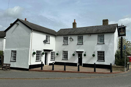
- Price
- Offers in Excess of£385,000
Crown 5 Church St, Litlington, SG8, Litlington, Cambridgeshire SG8 England
Added on 12/06/2026Commercial Land
- Price
- Guide Price£550,000
- Floor area
- 2,222 sq ft
Park Road, Kempston, Bedford, Bedfordshire, MK42, Kempston, Bedford MK42 England
Added on 11/09/2026Industrial Land