
10.17 Acres (Lot B) of Land, Paywell Lane, Blagdon, Bristol, BS40
- Land size
- 10.17 acres
Description
10.17 Acres (Lot B) of Land
Blagdon, Bristol, BS40 7XL
Key Details
An attractive opportunity to purchase a ring-fenced block of agricultural land extending to 10.17 acres or thereabouts.
Freehold
Guide Price
Lot B - 10.17 acres £100,000
-Mains water connection
Description
SITUATION
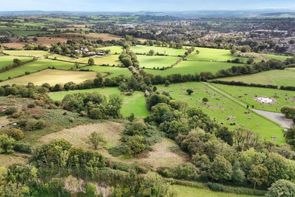
Situated within a traditional Mendip Hills farming landscape characterised by livestock grazing and a strong rural agricultural character, the land is ideally situated for a grass based farming system with the land commanding exceptional views of the Mendip Hills and wider Somerset landscape.
The land is surrounded by farmsteads, rural dwellings and agricultural land, providing an opportunity for purchasers to extend and expand their existing agricultural operations, or the potential to develop a new or bolt-on agricultural unit (subject to obtaining the necessary statutory consents). The land has been well farmed and managed over the years and is an exciting opportunity for potential purchasers.
Lot B
The land is situated to the north of Paywell Lane providing 10.17 acres of permanent pasture across two distinct field parcels. the land is bordered by well maintained mature hedgerow and livestock fencing to part, with some hedgerow trees present. There is a natural pond present within the southern field parcel which extends to approximately 362sq.m (surface area) as illustrated on the site plan.
The land is slightly sloping in topography to parts and is classified as Grade III and IV under the DEFRA Land Classification Map and is ideally suited for a range of agricultural, equestrian and amenity buyers (subject to obtaining the necessary consents). The land benefits from two points of access along the southern boundary.
ACCESS
Lot B: This land benefits from an independent access off Paywell Lane to the South.
STATUTORY DESIGNATIONS
The land is situated in an SSSI Impact Risk Zone, where planning applications are assessed for likely impacts on nearby SSSIs/SACs/SPAs and Ramsar sites.
The land is situated within the Mendip Hills National Landscape.
TOWN AND COUNTRY PLANNING
The land, notwithstanding any description contained in these particulars, is sold subject to any Development Plan, Tree Preservation Order, Town Planning Schedule, resolution or notice which may be, or may come to be, in force, and
also subject to any statutory provisions or byelaws, without any obligation on the part of the vendors to specify them. The purchaser shall be deemed to have full knowledge of, and to have satisfied themselves about, the provisions of any
such matter affecting the property.
DEVELOPMENT CLAWBACK
The land and building are being sold free of any development clawback provision.
ENVIRONMENTAL LAND MANAGEMENT SCHEMES (ELMS)
The land is not subject to any existing ELMS, as far as we are aware.
RIGHTS OF WAY, WAYLEAVES AND EASEMENTS
We have been informed that a mains water pipeline crosses part of Lot A and Lot B and understand that the relevant easement exists, which we understand connects to the compound owned by Bristol Water to the North-West boundary.
We have not been provided with a copy of the easement or informed of any further details.
The purchasers of Lot B will own the land which is cross-hatched brown on the site plan. However, a right of way for all purposes at all times will be granted to the purchaser of Lot A to provide access off Paywell Lane, via the existing access.
The property is sold and so far as required by the Vendors will be conveyed subject to all easements, quasi-easements, privileges and advantages (whether way of water, drainage, light or laying and maintaining water and other pipes or mains of any nature whatsoever) for the benefit of any other property as the owner, tenants or occupiers thereof now or have been accustomed to use, enjoy or exercise. The property is sold subject to all easements and wayleaves of telegraph and telephone poles and stays and wires, and electric pylons, pipes (whether poles and cables, water, gas and other referred to in these Particulars or not) at present erected on and passing over or under the property, and subject to the Agreements affecting the same (if any) and to the Town and Country Planning Scheme, or County, Local Authority or any other statutory
body affecting the same.
AGENTS NOTE
We have been informed that parts of the southern field parcels of Lot A and Lot B have historically had traces of lead within the soil. Over the years the landowner has regularly applied lime to the affected areas. We understand the remainder of the land is unaffected, although lime has been applied across the holding as a whole. Interested parties should make their own enquiries and
undertake any soil testing that they deem fit in order to satisfy themselves in this regard.
It is noted that at present there is no access between the two field parcels that form Lot B and it will be to the discretion of the eventual buyer of Lot B, where an access is to be located (subject to any necessary consent which may exist). In the event that Lot A and B are purchased by different parties, it will be the joint responsibility of the purchasers of Lots A and B to erect a stock proof fence between points X-Y on the site plan. The exact specification of the fence is to be negotiated and agreed between the purchasers with the fence to be erected within 6 weeks of completion.
Services & Additional Information
Services & Outgoings
We understand the land has a mains water connection, with two livestock drinking troughs present, one of which is shared between the two
lots.
We have been informed that there is spring-fed pond on Lot B. This is not metered and potentialpurchasers should make their own enquiries regarding the water quality. We are not aware of any outgoings relating to the land.
Rights & Restrictions
Please see main description.
Flooding
The land is located within Flood Zone 1, as defined by the Environment Agency, and we have been informed by the sellers that the land has never flooded.
Planning
The land, notwithstanding any description contained in these particulars, is sold subject to any Development Plan, Tree Preservation Order,
Town Planning Schedule, resolution or notice which may be, or may come to be, in force, and also subject to any statutory provisions or
byelaws, without any obligation on the part of the vendors to specify them. The purchaser shall be deemed to have full knowledge of, and to have satisfied themselves about, the provisions of any such matter affecting the property.
Directions
What3Words: ///streak.origin.manly
Important Notices
Disclaimer & Important Information
Greenslade Taylor Hunt, their clients and any joint agents give notice that:
They are not authorised to make or give any representations or warranties in relation to the property either here or elsewhere, either on their own behalf or on behalf of their client or otherwise. They assume no responsibility for any statement that may be made in these particulars. These particulars do not form part of any offer or contract and must not be relied upon as statements or representations of fact. For clarification we wish to inform any prospective purchasers that whilst we endeavour to make our sales particulars as accurate and reliable as possible, they have been prepared as a general guide. If there are any points which are of particular importance to you, please contact the office, especially if you are contemplating travelling some distance to view the property.
Any areas, measurements or distances are approximate and any room sizes provided should not be relied upon for carpets or furnishings. The text, photographs and plans are for guidance only and are not necessarily comprehensive. Any field numbers and areas shown on the attached plan are based on the Ordnance Survey and are for
identification purposes only. They do not necessarily correspond either with the National
Grid plan numbers or with those produced on the Rural Land Register.
It should not be assumed that the property has all necessary planning, building regulation or other consents and Greenslade Taylor Hunt has not carried out a detailed survey, tested any services, equipment, facilities or appliances. Purchasers must satisfy themselves by inspection or otherwise. We have not made any investigations into the existence or otherwise of any issues
concerning pollution of land, air or water contamination and the purchaser is responsible for making their own enquiries in this regard.
Viewing Health & Safety Policy
In accordance with our Health and Safety policy all parties undertaking viewings do so at their own risk. In the event of the property being a site with associated risks/renovation requirements, and if so directed by a member of GTH viewers must wear their own appropriate Personal Protection Equipment (PPE). Viewers must be vigilant when viewing working farms/land, particularly around the farmyard and in fields containing stock. All potential purchasers are asked to observe the country code and close all gates. If interested parties do not adhere to our policy and view the site unaccompanied (or without PPE) we/the seller cannot be held liable for any damage or personal injury or associated claim for compensation.
Contact Us
HENRY WORLE
Redhill
0117 203 5577
henry.worle@gth.net
Viewings strictly by appointment with the agents, Greenslade Taylor Hunt
Directions
From the Cathedral City of Wells, proceed north on the Old Bristol Road for approximately 5 miles and turn right onto Plummers Lane and take an immediate left to continue along Old Bristol Road. Continue for approximately 4 miles and turn left onto Bushy Road. Continue for approximately 0.4 miles, where the entrance to the land will be on the right hand side, as demarcated by our ‘For Sale’ board.
Alternatively, from Cheddar proceed north on Shipham Road for approximately 1.5 miles and turn right onto Longbottom Lane (which transitions onto Ivy Lane), for approximately 4 miles. Turn left onto Bushy Road and continue for 0.5 miles, where the entrance to the land will be on the left hand side, as demarcated by our ‘For Sale’ board.
Directions
What3Words: ///streak.origin.manly
Map Location
Property details
- Tenure
- Ask Agent
- Council Tax Band
- Ask Agent
- Date Posted
- 2026-10-30
Market Value Analysis
Compared with 164 Farmland & Pasture listings in South West England (10+ acres).
Property Brochure
Seen the details? The full report adds the independent checks: planning activity, flood history, heritage and ground.
Utilities & Restrictions
Utilities
- Electricity
- Ask Agent
- Water
- Ask Agent
- Heating
- Ask Agent
- Broadband
- Ask Agent
- Sewerage
- Ask Agent
Rights & Restrictions
- Public Rights of Way
- Ask Agent
- Private Rights of Way
- Ask Agent
- Listed Property
- Ask Agent
- Restrictions
- Ask Agent
Listed status, conservation areas and planning constraints for this location are in the full report.
Property Features
- Accessibility
- Ask Agent
- Parking
- Ask Agent
- Garden
- Ask Agent
Beyond the particulars: planning activity, flood history, heritage and ground risks, checked for this exact spot.
Connectivity
Broadband
Fastest speed available at this postcode
9 Mbps
Under 10 Mbps here
Suitable for
- Basic browsing & email
Mobile signal
Predicted 4G and 5G signal; indoor signal depends on building materials.
Ofcom Connected Nations postcode-level predictions. Speeds and signal are modelled, not measured, and vary between addresses and providers.
Signal is the easy part. Planning activity, flood history and protected designations here are in the full report.
Nearest Schools
Primary
- Blagdon Primary School1.4 milesOfsted: Good
- Ages
- 4 to 11
- Pupils
- 91
- Type
- Academy sponsor led
- Ubley Church of England Primary School1.9 milesOfsted: Good
- Ages
- 4 to 11
- Pupils
- 67
- Type
- Academy converter
- Faith
- Church of England
- Burrington Church of England Primary School2.5 milesOfsted report card · Nov 2025
- Ages
- 3 to 11
- Pupils
- 107
- Type
- Academy converter
- Faith
- Church of England
- Priddy Primary School3.5 milesNo Ofsted rating
- Ages
- 4 to 11
- Pupils
- 44
- Type
- Community school
- Cheddar First School3.6 milesOfsted: Good *
- Ages
- 2 to 9
- Pupils
- 358
- Type
- Academy converter
Secondary
- Fairlands Middle School3.3 milesOfsted: Good *
- Ages
- 9 to 13
- Pupils
- 405
- Type
- Academy converter
- The Kings of Wessex Academy3.6 milesNo Ofsted rating
- Ages
- 13 to 18
- Pupils
- 1,043
- Type
- Academy converter
- Faith
- Church of England
- Churchill Academy & Sixth Form4.8 milesOfsted: Good *
- Ages
- 11 to 18
- Pupils
- 1,488
- Type
- Academy converter
- Chew Valley School5.3 milesOfsted report card · May 2026
- Ages
- 11 to 18
- Pupils
- 1,180
- Type
- Academy converter
- The Blue School6.8 milesNo Ofsted rating
- Ages
- 11 to 18
- Pupils
- 1,362
- Type
- Academy converter
- Faith
- Church of England
* Latest graded judgement covers quality of education only; no overall grade was issued under the 2024-25 inspection framework.
Distances are straight-line from the advertised location. Source: the national school registers (DfE, Welsh Government, Scottish Government) and Ofsted.
Schools are just the start: sold prices nearby, planning activity and any flood history are in the full report.
Amenities
Supermarket
GP surgery
Pharmacy
Hospital
Straight-line distances from the advertised location. Sources: NHS records, Geolytix supermarket locations, OS Open Greenspace and the national trails registers.
The area stacks up? Now check the location itself: planning nearby, protected designations and past flooding.
Getting Around
Nearest station
Nearest bus stop
Typical drive times
Straight-line distances from the advertised location; drive times are typical free-flow times over OpenStreetMap road data, so allow more at peak. Public transport locations from DfT NaPTAN.
Easy to reach matters. So do planning activity, flood history and ground risks: all in the full report.
Flood Risk
Environment Agency open data, checked around the advertised map pin for the listed acreage. Long-term risk counts flood defences; the planning map's flood zones do not. Provided by LandSale, not the listing agent, and not part of the agent's particulars. Risk varies across a holding, so verify before committing.
Rivers and the sea
Planning map: Flood Zone 1.
Surface water
These bandings are the summary. Where this location sits on the flood maps, plus planning activity, heritage and ground risks, is in the full report.
Important notice: Information, maps and tags on this page are drawn from the advertising agent's marketing materials or generated automatically. LandSale has not verified them. Relying on these details is at your own risk, always carry out independent checks before committing to a purchase.
LandSale full disclaimer
Marketing information only - not formal particulars. The details on this website are provided for general guidance and do not constitute an offer or contract. Neither LandSale nor the advertising estate/land agent accepts responsibility for any inaccuracy.
1. Source of information
- Listing content: Core description, asking price, tenure, measurements, photographs and planning history originate from the marketing materials of the advertising estate or land agent. LandSale does not author this content and cannot guarantee its accuracy.
- Automated tags & categorisation: Property type, land-use class, acreage bands and similar labels may be applied by machine-learning models. They are intended as a helpful guide only and may not reflect the property's legal status or permitted use.
- Third-party & enriched data layers: Maps, boundary outlines, planning designations, soil reports, broadband coverage and other environmental or location-based insights are licensed from external suppliers. Such data are supplied “as is", may be incomplete or out of date and are subject to change without notice.
2. Verification required
Prospective purchasers must verify critical matters, including but not limited to planning permission, title boundaries, public rights of way, environmental constraints, acreage, services, access and VAT status, through their own inspections, specialist surveys, legal advisers and the selling agent before relying on the information or entering into any contract.
3. No warranty or liability
LandSale gives no warranty, express or implied, as to the accuracy, completeness or fitness for any particular purpose of the information displayed. LandSale shall not be liable for any loss, damage, cost or expense arising directly or indirectly from any use of or reliance on such information, save where liability may not be excluded by law.
4. Updates & feedback
If you believe any detail on this listing is inaccurate, please let us know. We will investigate and, where appropriate, update the listing or notify the agent.
© LandSale | Version 1.3 - August 2026
Similar properties for sale
- Price
- Guide Price£100,000
- Size
- 7.05 acres
Land At Windsor Hill, Shepton Mallet, Somerset, BA4, Shepton Mallet, Somerset BA4 England
Added on 20/10/2026Pasture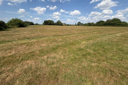
- Price
- Guide Price£95,000
- Size
- 7.98 acres
Limington Road, Yeovil, Yeovilton and District, Somerset BA22 England
Added on 28/09/2026Agricultural Land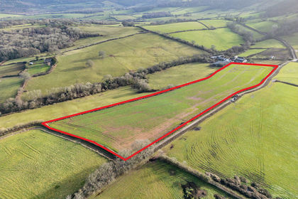
- Price
- Guide Price£90,000
- Size
- 7.41 acres
Land at Llangwm, Usk, Monmouthshire, NP15, Usk, Monmouthshire NP15 Wales
Added on 29/01/2026Agricultural Land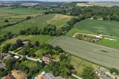
- Price
- Guide Price£120,000
- Size
- 8 acres
Land at West Farm, Knook, Warminster BA12, Knook, Wiltshire BA12 England
Added on 26/10/2026Agricultural Land
- Price
- Guide Price£100,000
- Size
- 7.56 acres
Gannetts, Todber, Sturminster Newton, Todber, Dorset DT10 England
Added on 30/09/2026Farmland
- Price
- Guide Price£95,000
- Size
- 6.45 acres
Gannetts, Todber, Sturminster Newton, Todber, Dorset DT10 England
Added on 30/09/2026Farmland
- Price
- Offers in Excess of£125,000
- Size
- 12.75 acres
Usk, Monmouthshire, NP15, Llantrisant Fawr, Monmouthshire NP15 Wales
Added on 29/07/2026Grazing Land
- Price
- Offers in Region of£80,000
- Size
- 7.46 acres
Trellech, Monmouth, NP25, Trellech United, Monmouthshire NP25 Wales
Added on 07/10/2026Pasture
- Price
- Guide Price£85,000
- Size
- 8.84 acres
Added on 10/06/2026Farmland
- Price
- Guide Price£75,000
- Size
- 5 acres
Added on 13/06/2026Grazing Land