Paddock, Sugar Loaf Lane, Stourbridge
- Land size
- 2 acres
Description
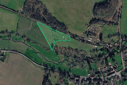
An excellent opportunity to acquire approximately 2 acres of land situated on Sugar Loaf Lane, Stourbridge. The land is currently used for equestrian grazing, making it an ideal prospect for those seeking grazing land for horses or other suitable agricultural or recreational uses, subject to the necessary consents.
Offering a generous parcel of land with water in an established location, this property presents an appealing opportunity for equestrian owners, local farmers or buyers looking to secure additional land for personal use.
Early viewing is recommended to appreciate the land and its potential.
Access - Gate from Sugar loaf lane and Fairy Glen bridle path gives access onto the plot.
Money Laundering Regulations. - By law, we are required to conduct anti-money laundering checks on all potential buyers and sellers, and we take this responsibility very seriously. In line with HMRC guidelines, our trusted partner, Coadjute, will securely manage these checks on our behalf. Once an offer is accepted (subject to contract), Coadjute will send a secure link for you to complete the biometric checks electronically. A non-refundable fee of £45+ VAT per person will apply for these checks, and Coadjute will handle the payment for this service. These anti-money laundering checks must be completed before we can send the memorandum of sale to the solicitors to confirm the sale. Please contact the office if you have any questions in relation to this.
Referral Fees. - We can confirm that if we are sourcing a quotation or quotations on your behalf relevant to the costs that you are likely to incur for the professional handling of the conveyancing process. You should be aware that we could receive a maximum referral fee of approximately £300 inc VAT should you decide to proceed with the engagement of the solicitor in question. We are informed that solicitors are happy to pay this referral fee to ourselves as your agent as it significantly reduces the marketing costs that they have to allocate to sourcing new business. The referral fee is NOT added to the conveyancing charges that would ordinarily be quoted.
We can also confirm that if we have provided your details to Infinity Financial Advice who we are confident are well placed to provide you with the very best possible advice relevant to your borrowing requirements. You should be aware that we receive a referral fee from Infinity for recommending their services. The charges that you will incur with them and all the products that they introduce to you will in no way be affected by this referral fee. On average the referral fees that we have received recently are £218 per case.
The same also applies if we have introduced you to the services of surveyors who we are confident will provide you with a first class service relevant to your property needs, we will again receive a maximum referral fee of £200 inc vat. This referral fee does not impact the actual fee that you would pay had you approached them direct as it is paid to us as an intermediary on the basis that we save them significant marketing expenditure in so doing. If you have any queries regarding the above, please feel free to contact us.
Tenure (Freehold). - References to the tenure of a property are based on information supplied by the seller. We are advised that the property is freehold. A buyer is advised to obtain verification from their solicitor.
Map Location
Property details
- Tenure
- Freehold
- Council Tax Band
- Ask Agent
- Date Posted
- 2026-10-29
Market Value Analysis
Compared with 164 Farmland & Pasture listings in West Midlands (1+ acres).
Utilities & Restrictions
Utilities
- Electricity
- Ask Agent
- Water
- Ask Agent
- Heating
- Ask Agent
- Broadband
- Ask Agent
- Sewerage
- Ask Agent
Rights & Restrictions
- Public Rights of Way
- Ask Agent
- Private Rights of Way
- Ask Agent
- Listed Property
- Ask Agent
- Restrictions
- Ask Agent
Listed status, conservation areas and planning constraints for this location are in the full report.
Property Features
- Accessibility
- Ask Agent
- Parking
- Ask Agent
- Garden
- Ask Agent
Beyond the particulars: planning activity, flood history, heritage and ground risks, checked for this exact spot.
Connectivity
Broadband
Fastest speed available at this postcode
33 Mbps
Superfast · available to 8% of premises
Suitable for
- HD streaming
- Video calls
- Web & social
Mobile signal
Predicted 4G and 5G signal; indoor signal depends on building materials.
Ofcom Connected Nations postcode-level predictions. Speeds and signal are modelled, not measured, and vary between addresses and providers.
Signal is the easy part. Planning activity, flood history and protected designations here are in the full report.
Nearest Schools
Primary
- Blakedown CofE Primary School1.7 milesNo Ofsted rating
- Ages
- 5 to 11
- Pupils
- 194
- Type
- Voluntary controlled school
- Faith
- Church of England
- Gig Mill Primary School1.7 milesOfsted: Good
- Ages
- 2 to 11
- Pupils
- 535
- Type
- Academy converter
- St Joseph's RC Primary School1.8 milesNo Ofsted rating
- Ages
- 5 to 11
- Pupils
- 201
- Type
- Academy converter
- Faith
- Roman Catholic
- The Ridge Primary School2 milesNo Ofsted rating
- Ages
- 3 to 11
- Pupils
- 236
- Type
- Community school
- Hagley Primary School2.1 milesOfsted: Good
- Ages
- 3 to 11
- Pupils
- 667
- Type
- Community school
Secondary
- Haybridge High School and Sixth Form1.5 milesOfsted: Good
- Ages
- 11 to 18
- Pupils
- 1,226
- Type
- Academy converter
- Hagley Catholic High School1.5 milesOfsted: Good
- Ages
- 11 to 18
- Pupils
- 1,088
- Type
- Academy converter
- Faith
- Roman Catholic
- Ridgewood High School2.1 milesOfsted: Good
- Ages
- 11 to 16
- Pupils
- 641
- Type
- Academy converter
- Old Swinford Hospital2.3 milesNo Ofsted rating
- Ages
- 11 to 18
- Pupils
- 1,036
- Type
- Voluntary aided school
- Faith
- Church of England
- Redhill School2.6 milesOfsted: Good
- Ages
- 11 to 16
- Pupils
- 1,204
- Type
- Academy converter
Distances are straight-line from the advertised location. Source: the national school registers (DfE, Welsh Government, Scottish Government) and Ofsted.
Schools are just the start: sold prices nearby, planning activity and any flood history are in the full report.
Amenities
Supermarket
GP surgery
Pharmacy
Hospital
Straight-line distances from the advertised location. Sources: NHS records, Geolytix supermarket locations, OS Open Greenspace and the national trails registers.
The area stacks up? Now check the location itself: planning nearby, protected designations and past flooding.
Getting Around
Nearest station
Nearest bus stop
Typical drive times
Straight-line distances from the advertised location; drive times are typical free-flow times over OpenStreetMap road data, so allow more at peak. Public transport locations from DfT NaPTAN.
Easy to reach matters. So do planning activity, flood history and ground risks: all in the full report.
Flood Risk
Environment Agency open data, checked around the advertised map pin for the listed acreage. Long-term risk counts flood defences; the planning map's flood zones do not. The map pin for this listing is approximate, so these readings describe the surrounding area. Provided by LandSale, not the listing agent, and not part of the agent's particulars. Risk varies across a holding, so verify before committing.
Rivers and the sea
Planning map: Flood Zone 1.
Surface water
Not at the pin: mapped about 10 metres away.
These bandings are the summary. Where this location sits on the flood maps, plus planning activity, heritage and ground risks, is in the full report.
Important notice: Information, maps and tags on this page are drawn from the advertising agent's marketing materials or generated automatically. LandSale has not verified them. Relying on these details is at your own risk, always carry out independent checks before committing to a purchase.
LandSale full disclaimer
Marketing information only - not formal particulars. The details on this website are provided for general guidance and do not constitute an offer or contract. Neither LandSale nor the advertising estate/land agent accepts responsibility for any inaccuracy.
1. Source of information
- Listing content: Core description, asking price, tenure, measurements, photographs and planning history originate from the marketing materials of the advertising estate or land agent. LandSale does not author this content and cannot guarantee its accuracy.
- Automated tags & categorisation: Property type, land-use class, acreage bands and similar labels may be applied by machine-learning models. They are intended as a helpful guide only and may not reflect the property's legal status or permitted use.
- Third-party & enriched data layers: Maps, boundary outlines, planning designations, soil reports, broadband coverage and other environmental or location-based insights are licensed from external suppliers. Such data are supplied “as is", may be incomplete or out of date and are subject to change without notice.
2. Verification required
Prospective purchasers must verify critical matters, including but not limited to planning permission, title boundaries, public rights of way, environmental constraints, acreage, services, access and VAT status, through their own inspections, specialist surveys, legal advisers and the selling agent before relying on the information or entering into any contract.
3. No warranty or liability
LandSale gives no warranty, express or implied, as to the accuracy, completeness or fitness for any particular purpose of the information displayed. LandSale shall not be liable for any loss, damage, cost or expense arising directly or indirectly from any use of or reliance on such information, save where liability may not be excluded by law.
4. Updates & feedback
If you believe any detail on this listing is inaccurate, please let us know. We will investigate and, where appropriate, update the listing or notify the agent.
© LandSale | Version 1.3 - August 2026
Contact Lex Allan, Stourbridge
The Auction House, 87/88 St. Johns Road, Stourbridge, DY8 1EH
View agent profileSimilar properties for sale
- Price
- £70,000
- Size
- 2.34 acres
Added on 14/09/2026Grazing Land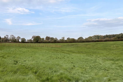
- Price
- Guide Price£70,000
- Size
- 2.05 acres
Barnsfield, Alvechurch, Birmingham, Tutnall and Cobley, Worcestershire B48 England
Added on 13/10/2026Pasture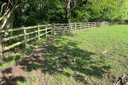
- Price
- Offers in Excess of£100,000
- Size
- 6.42 acres
Gunstone Lane, Codsall, WV8, Codsall, Staffordshire WV8 England
Added on 29/01/2026Grazing Land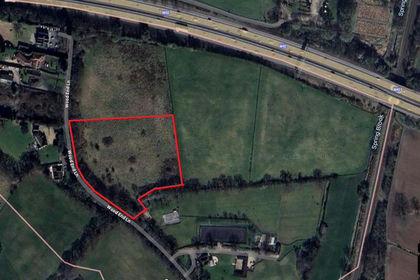
- Price
- £95,000
- Size
- 3.7 acres
Land at Wood End Lane, Tanworth in Arden, B94, Tanworth-in-Arden, Warwickshire B94 England
Added on 15/07/2026Grazing Land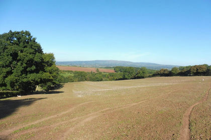
- Price
- Guide Price£110,000
- Size
- 11.36 acres
LAND - 11.36 Acres Hanley William WR15, Hanley, Worcestershire WR15 England
Added on 29/01/2026Agricultural Land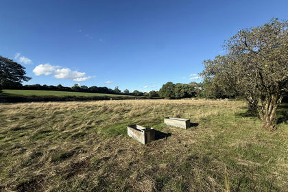
- Price
- £50,000
- Size
- 1.84 acres
Nether Lane, Burntwood, WS7, Burntwood, Staffordshire WS7 England
Added on 24/09/2026Agricultural Land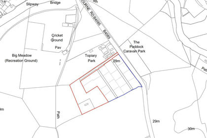
- Price
- Guide Price£75,000
- Size
- 2.8 acres
Honeybourne Road, Bidford-On-Avon, Bidford-on-Avon, Warwickshire B50 England
Added on 04/07/2026Grazing Land
- Price
- £50,000
- Size
- 4.5 acres
At Penkridge Bank Road, Slitting Mill, Rugeley, Brindley Heath, Staffordshire WS15 England
Added on 23/10/2026Woodland
- Price
- Guide Price£50,000
- Size
- 4.54 acres
Trinity Road, Kingsbury, Kingsbury, Warwickshire B78 England
Added on 02/10/2026Woodland
- Price
- £100,000
- Size
- 8.69 acres
All Stretton, Church Stretton, Shropshire, Church Stretton, Shropshire SY6 England
Added on 29/01/2026Grazing Land