Bond International, Newhouse Farm Industrial Estate, Chepstow, Monmouthshire
- Floor area
- 106,024 sq ft
- Use Class
- Use Class: B8
Key Features
- 2 Detached Warehouses.
- Available with Vacant Possession.
- B8 Use.
- Value Add Opportunity: Of interest to Investors and Owner Occupiers.
Description
LOCATION
The property is located within Newhouse Industrial Estate, Chepstow. This is an established industrial area with excellent transport links, situated
adjacent to Junction 2 of the M48 and the first Severn Bridge. The M4/M5 interchange nearby provides direct routes to the Midlands, London and the wider South West region. There is a mainline railway station in Chepstow with routes to Gloucester, Newport and Cardiff. The property is also within close proximity to J23 of the M4, which provides easy access to Newport, Cardiff and South Wales, with J23A providing access to the M4 Prince of Wales Bridge.
Drive Times
Approx travel times by car.
Bristol 15 miles 20 mins
Newport 18 miles 25 mins
Bath 30 miles 45 mins
Cardiff 30 miles 50 mins
Gloucester 36 miles 50 mins
London 125 miles 2 hrs 30 mins
DESCRIPTION
The property itself comprises two substantial, detached warehouses.
UNIT 2 has a minimum eaves height of approximately 7.48 metres. The warehouse also has 4 dock loading bays measuring approximately 3.48 metres wide by 3.16 metres high. The right hand side of the warehouse has also been extended, with a lower eaves than the main building.
UNIT 3 has a minimum eaves height of approximately 6.72 metres, 6 roller shutter doors of varying heights and widths along with 14 dock loading bays, with 11 currently in use. Each dock level bay measures approximately 2.15 metres wide by 2.80 metres high. Above the reception area are first floor offices, and adjacent the dock loading bay is a staff breakout area. Both units are of portal steel frame construction with brick elevations at lower level, with the remainder of the elevations and the roof being clad thereover with profile metal sheets. Floors are solid concrete. The warehouses would appeal to owner occupiers and investors.
Use:
B8 (Storage and Distribution).
EPC:
UNIT 2 – B (45) UNIT 3 – C (51)
Asset Management
Whilst the property is suitable for immediate occupation, there is potential to refurbish and let both warehouses, which would potentially increase ERV. Chepstow has an extremely limited supply of warehouse space available to let, with little coming to the open market in recent years. By separate negotiation with the neighbouring landowner, there is a area of land of approximately 0.15 acres between the two warehouses which could be purchased. The landowner has expressed willingness to potentially sell this area of land. A purchase of this land would allow accessibility between the two warehouses.
Anti Money Laundering
In order to discharge its legal obligations, including under applicable anti-money laundering regulations, Bladen Property will require certain information of the purchaser, including source of funds. In submitting an offer, you agree to provide such information when Heads of Terms are agreed.
VAT
We understand the property has been elected for VAT.
Business Rates
UNIT 2 £228,000 (1 April 2026)
UNIT 3 £148,000 (1 April 2026)
Tenure
To be sold with vacant possession. We are advised that Unit 2 is held Freehold and Unit 3 is Long Leasehold for a term of 999 years from 15 June 1989 at a peppercorn ground rent.
Purchase Price
Offers in excess of £5,800,000 (five million eight hundred thousand pounds), for the two warehouses sold together as a pair. Offers for each warehouse in isolation will be considered.
A purchase at this level reflects a low capital value of just £54.70 per square foot. Warehouses in this location rarely come to the open market, especially with vacant possession.
UNIT 2 – Offers in excess of £3.275M.
UNIT 3 – Offers in excess of £2.55M.
FURTHER INFORMATION
To arrange a viewing or for more information, please contact the sole agent.
KIERAN BLADEN
E:
M:
Important Notice. These particulars do not constitute an offer or contract and although they are believed to be correct their accuracy cannot be guaranteed and they are expressly excluded from any contract. Subject to contract. Moose Studios Oct ‘26.
Map Location
Property details
- Tenure
- Ask Agent
- Council Tax Band
- Ask Agent
- Date Posted
- 2026-10-23
Utilities & Restrictions
Utilities
- Electricity
- Ask Agent
- Water
- Ask Agent
- Heating
- Ask Agent
- Broadband
- Ask Agent
- Sewerage
- Ask Agent
Rights & Restrictions
- Public Rights of Way
- Ask Agent
- Private Rights of Way
- Ask Agent
- Listed Property
- Ask Agent
- Restrictions
- Ask Agent
Listed status, conservation areas and planning constraints for this location are in the full report.
Property Features
- Accessibility
- Ask Agent
- Parking
- Ask Agent
- Garden
- Ask Agent
Beyond the particulars: planning activity, flood history, heritage and ground risks, checked for this exact spot.
Connectivity
Broadband
Fastest speed available at this postcode
1.8 Gbps
Gigabit full fibre · available to 93% of premises
Suitable for
- 4K streaming on every screen
- Full-time home working
- Online gaming & big downloads
Mobile signal
Predicted 4G and 5G signal; indoor signal depends on building materials.
Ofcom Connected Nations postcode-level predictions. Speeds and signal are modelled, not measured, and vary between addresses and providers.
Signal is the easy part. Planning activity, flood history and protected designations here are in the full report.
Nearest Schools
Primary
- Thornwell Primary School874 metres
- Pupils
- 254
- Type
- Nursery, Infants & Juniors
- Language
- English medium school / provision
- Pembroke Primary0.9 miles
- Pupils
- 262
- Type
- Nursery, Infants & Juniors
- Language
- English medium school / provision
- St Mary'S R.C.P.School1.2 miles
- Pupils
- 117
- Type
- Infants & Juniors
- Language
- English medium school / provision
- The Dell Primary1.8 miles
- Pupils
- 398
- Type
- Infants & Juniors
- Language
- English medium school / provision
- Archbishop Rowan Williams Va2.8 miles
- Pupils
- 210
- Type
- Infants & Juniors
- Language
- English medium school / provision
Secondary
- Chepstow Comprehensive School2.1 miles
- Pupils
- 860
- Type
- Secondary (ages 11-19)
- Language
- English medium school / provision
- Caldicot School3.8 miles
- Pupils
- 1,247
- Type
- Secondary (ages 11-19)
- Language
- English medium school / provision
- Llanwern High School11 miles
- Pupils
- 1,101
- Type
- Secondary (ages 11-19)
- Language
- English medium school / provision
- Caerleon Comprehensive School12 miles
- Pupils
- 1,471
- Type
- Secondary (ages 11-19)
- Language
- English medium school / provision
- Lliswerry High School12 miles
- Pupils
- 1,079
- Type
- Secondary (ages 11-19)
- Language
- English medium school / provision
Distances are straight-line from the advertised location. Source: the national school registers (DfE, Welsh Government, Scottish Government) and Ofsted.
Schools are just the start: sold prices nearby, planning activity and any flood history are in the full report.
Amenities
Supermarket
GP surgery
Pharmacy
Green space
Straight-line distances from the advertised location. Sources: NHS records, Geolytix supermarket locations, OS Open Greenspace and the national trails registers.
The area stacks up? Now check the location itself: planning nearby, protected designations and past flooding.
Getting Around
Nearest station
Nearest bus stop
Typical drive times
Straight-line distances from the advertised location; drive times are typical free-flow times over OpenStreetMap road data, so allow more at peak. Public transport locations from DfT NaPTAN.
Easy to reach matters. So do planning activity, flood history and ground risks: all in the full report.
Flood Risk
Natural Resources Wales open data, checked around the advertised map pin for the listed acreage. Long-term risk counts flood defences; the planning map's flood zones do not. Provided by LandSale, not the listing agent, and not part of the agent's particulars. Risk varies across a holding, so verify before committing.
Rivers and the sea
Planning map: Flood Zone 3.
Surface water
Not at the pin: mapped about 40 metres away.
These bandings are the summary. Where this location sits on the flood maps, plus planning activity, heritage and ground risks, is in the full report.
Important notice: Information, maps and tags on this page are drawn from the advertising agent's marketing materials or generated automatically. LandSale has not verified them. Relying on these details is at your own risk, always carry out independent checks before committing to a purchase.
LandSale full disclaimer
Marketing information only - not formal particulars. The details on this website are provided for general guidance and do not constitute an offer or contract. Neither LandSale nor the advertising estate/land agent accepts responsibility for any inaccuracy.
1. Source of information
- Listing content: Core description, asking price, tenure, measurements, photographs and planning history originate from the marketing materials of the advertising estate or land agent. LandSale does not author this content and cannot guarantee its accuracy.
- Automated tags & categorisation: Property type, land-use class, acreage bands and similar labels may be applied by machine-learning models. They are intended as a helpful guide only and may not reflect the property's legal status or permitted use.
- Third-party & enriched data layers: Maps, boundary outlines, planning designations, soil reports, broadband coverage and other environmental or location-based insights are licensed from external suppliers. Such data are supplied “as is", may be incomplete or out of date and are subject to change without notice.
2. Verification required
Prospective purchasers must verify critical matters, including but not limited to planning permission, title boundaries, public rights of way, environmental constraints, acreage, services, access and VAT status, through their own inspections, specialist surveys, legal advisers and the selling agent before relying on the information or entering into any contract.
3. No warranty or liability
LandSale gives no warranty, express or implied, as to the accuracy, completeness or fitness for any particular purpose of the information displayed. LandSale shall not be liable for any loss, damage, cost or expense arising directly or indirectly from any use of or reliance on such information, save where liability may not be excluded by law.
4. Updates & feedback
If you believe any detail on this listing is inaccurate, please let us know. We will investigate and, where appropriate, update the listing or notify the agent.
© LandSale | Version 1.3 - August 2026
Listing agent
Bladen Property Consultants, BristolRedland House, 157 Redland Road, Redland, Bristol, BS6 6YE
Contact Bladen Property Consultants, Bristol
Redland House, 157 Redland Road, Redland, Bristol, BS6 6YE
View agent profileSimilar properties for sale
- Price
- Offers in Excess of£5,250,000
- Floor area
- 77,525 sq ft
Evans House, Third Way, Avonmouth, Bristol, BS11, Bristol North West, Bristol, City of BS11 England
Added on 18/04/2026WarehouseLeasehold
- Price
- Offers in Region of£5,000,000
- Size
- 9.1 acres
Added on 25/05/2026Industrial Land
- Price
- Offers in Region of£5,250,000
- Floor area
- 172,892 sq ft
Added on 21/07/2026Industrial Land
- Price
- Guide Price£5,250,000
- Floor area
- 29,053 sq ft
Bumpers Way, Bumpers Farm Industrial Estate, Chippenham, Chippenham, Wiltshire SN14 England
Added on 05/10/2026Commercial Land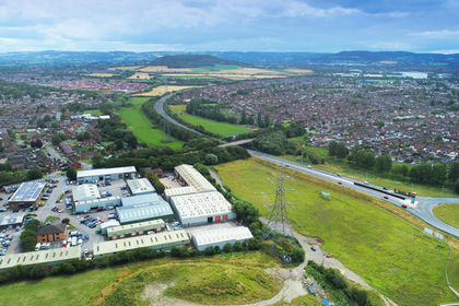
- Price
- Offers in Excess of£4,650,000
Added on 25/05/2026Warehouse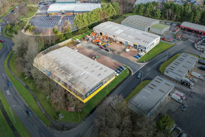
- Price
- Offers in Region of£5,000,000
- Size
- 3.85 acres
Enterprise Park Portfolio, Swansea Enterprise Park, Swansea, SA7, Llansamlet, Swansea SA7 Wales
Added on 05/11/2026Commercial LandLeasehold
- Price
- Offers in Excess of£4,500,000
- Floor area
- 117,418 sq ft
Bryntywod, Swansea, Wales, SA5, Llangyfelach, Swansea SA5 Wales
Added on 17/07/2026Warehouse