Auction: Wednesday 11 November 2026
Potential plot, next to 20 St. Whytes Road, Filwood, Bristol, Bristol BS4
Key Features
- For sale by Auction on 11th November 2026
- Guide price £30,000 - £50,000
- Parcel of land in residential area
- Potential for development, subject to panning
Description
A small parcel of land with potential for residential development, subject to planning. For sale by auction on the 11th November 2026
A level parcel of land situated the Filwood area of Bristol. For sale by online live stream auction on 11th November 2026.
Situated in a residential road between numbers 18 and 20 St. Whytes Road this is a former access to a now completed development. It is a level parcel of land measuring 30.3m deep by 6.5m wide totaling 195 sqm (measurements scaled from Pro Map). The land is suitable for a variety of different uses from storage to potential residential development, subject to the necessary planning consents.
Location and Local Information Situated in Filwood, near Novers Park, a residential part of south Bristol, with local shops and services nearby and larger shopping and leisure options around Hengrove and Imperial Park. Buses serve the area, though the best route depends on your exact destination.
What3words location///accent.roofs.robots
Accommodation Details This is an overgown parcel of land, enclosed on all sides. The site measures 30.3m deep by 6.5m wide totaling 195 sqm (measurements scaled from Pro Map). Benefits from double gated vehicular access
Tenure Details Freehold
Utilities & Services No known connections.
Viewing Arrangements Please contact City and Rural
Legal Pack & Due Diligence The legal pack is (or will be) available to download from our website.
It is expected to include title documentation, special conditions of sale, searches, EPC, tenancy documentation (if applicable), and any other relevant legal information.
We recommend all elements of the legal pack are reviewed by your and your conveyancer before bidding. You are deemed to bid in full knowledge of the contents of the legal pack whether you have reviewed it or not.
Your attention is drawn to the Special Conditions of Sale within the Legal Pack, which detail other charges in addition to the sale price which you may be liable for. These costs may include, but not limited to, Search Fees, reimbursement of Sellers costs and Legal Fees as well as Transfer Costs.
The Legal Pack is available to download, free of charge, via the City and Rural Property Auctions website. By registering for Legal Pack, you will be kept up to date of any changes that may occur in the build up to the auction.
Price & Auction Details • Guide price: £30,000 - £50,000
• Buyer’s Admin Fee: 0.5% inc VAT of the purchase price, subject to a minimum of £2,250 inc VAT, payable on exchange of contracts.
• Buyer’s Premium: £600 inc VAT.
• Method of sale: Traditional unconditional auction
• Auction date and time: For sale by auction on Wednesday 29th July 2026 at 6.30pm
• Exchange and completion: Exchange on the fall of the Auctioneer’s Gavel with completion 20 working days later.
Bidders Registration closes on 10th November 2026 You must register to bid to take part in the auction.
Step 1 – complete the online bidding form (this is the same form if you wish to do telephone or proxy bidding).
Step 2 – Upload your ID and Proof of Address
Step 3 – Pay your security deposit of £6,500 (this places a hold on your debit card and no money will leave your account unless you are the successful purchaser).
Step 4 – you will receive a confirmation email you are ready to bid.
Good luck at the auction! Any outstand deposit balance must be transferred to us within 24 hours of the auction. If you are unsuccessful at the auction the hold on your debit card will be cancelled within 24 hours of the auction, although the exact date will be determined by the issuing bank.
Mortgages and Bridging Finance There is finance available for virtually every lot, whether that’s a from a high street mortgage lender or from a short-term bridging finance company. We have a team of specialist auction third party mortgage brokers and finance providers that know the ins and outs of auctions, particularly the timescales required to complete, that are on hand to help. Please contact City and Rural Property Auctions for further details. Please note we may receive introductory fees from the broker for this service.
Legal Pack Review Service It is highly recommended that you have the legal pack reviewed by a conveyancer/solicitor. We work with a number of auction specialist firms that offer a paid for service that will undertake this for you at relatively short notice. Please contact us for further details.
Tenure: Freehold
Terms:
Guide Prices & Reserves
Guides are provided as an indication of each seller's minimum expectation. They are not necessarily figures which a property will sell for and may change at any time prior to the auction. Each property will be offered subject to a Reserve (a figure below which the Auctioneer cannot sell the property during the auction) which we expect will be set within the Guide Range or no more than 10% above a single figure Guide.
Additional Fees
Please be aware there may be additional fees payable on top of the final sale price. These include and are not limited to administration charges and buyer's premium fees payable on exchange, and disbursements payable on completion. Please ensure you check the property information page for a list of any relevant additional fees as well as reading the legal pack for any disbursements.
Plans, Maps and Photographs
The plans, floorplans, maps, photograph’s and video tours published on our website and in the catalogue are to aid identification of the property only. The plans are not to scale and should not be relied upon.
Consumer Protection Regulations 2008
City & Rural Property Auctions endeavour to make our sales details clear, accurate and reliable in line with the Consumer Protection from Unfair Trading Regulations 2008 but they should not be relied on as statements or representations of fact, and they do not constitute any part of an offer or contract. All references to planning, tenants, boundaries, potential development, tenure etc is to be superseded by the information contained in the legal pack. It should not be assumed that this property has all the necessary Planning, Building Regulation, or other consents. Any services, appliances and heating system(s) listed have not been checked or tested. Please note that in some instances the photographs may have been taken using a wide-angle lens. The seller does not make any representation or give any warranty in relation to the property, and we have no authority to do so on behalf of the seller.
Anti Money Laundering Regulations.
Intending buyers will be asked to produce identification documentation either as part of the bidder registration process of if they make an acceptable pre-auction offer, we would ask for your co-operation in order that there will be no delay in agreeing the sale.
Map Location
Property details
- Tenure
- Freehold
- Council Tax Band
- Ask Agent
- Date Posted
- 2026-10-21
Utilities & Restrictions
Utilities
- Electricity
- Ask Agent
- Water
- Ask Agent
- Heating
- Ask Agent
- Broadband
- Ask Agent
- Sewerage
- Ask Agent
Rights & Restrictions
- Public Rights of Way
- Ask Agent
- Private Rights of Way
- Ask Agent
- Listed Property
- Ask Agent
- Restrictions
- Ask Agent
Listed status, conservation areas and planning constraints for this location are in the full report.
Property Features
- Accessibility
- Ask Agent
- Parking
- Ask Agent
- Garden
- Ask Agent
Beyond the particulars: planning activity, flood history, heritage and ground risks, checked for this exact spot.
Connectivity
Broadband
Fastest speed available at this postcode
1.8 Gbps
Gigabit full fibre
Suitable for
- 4K streaming on every screen
- Full-time home working
- Online gaming & big downloads
Mobile signal
Predicted 4G and 5G signal; indoor signal depends on building materials.
Ofcom Connected Nations postcode-level predictions. Speeds and signal are modelled, not measured, and vary between addresses and providers.
Signal is the easy part. Planning activity, flood history and protected designations here are in the full report.
Nearest Schools
Primary
- School of Christ The King Catholic Primary401 metresOfsted: Good
- Ages
- 3 to 11
- Pupils
- 227
- Type
- Voluntary aided school
- Faith
- Roman Catholic
- Oasis Academy Connaught466 metresOfsted: Requires improvement *
- Ages
- 3 to 11
- Pupils
- 310
- Type
- Academy sponsor led
- E-ACT Greenfield Primary Academy601 metresOfsted: Good *
- Ages
- 3 to 11
- Pupils
- 332
- Type
- Academy converter
- Oasis Academy Marksbury Road0.7 milesNo Ofsted rating
- Ages
- 4 to 11
- Pupils
- 355
- Type
- Academy sponsor led
- E-ACT Ilminster Avenue Academy0.7 milesOfsted: Requires improvement *
- Ages
- 4 to 11
- Pupils
- 229
- Type
- Academy sponsor led
Secondary
- Oasis Academy Daventry Road964 metresNo Ofsted rating
- Ages
- 11 to 16
- Pupils
- 362
- Type
- Free schools
- Oasis Academy John Williams1.2 milesOfsted: Good
- Ages
- 11 to 16
- Pupils
- 858
- Type
- Academy sponsor led
- Bedminster Down School1.2 milesOfsted: Good *
- Ages
- 11 to 16
- Pupils
- 1,022
- Type
- Academy converter
- Bridge Learning Campus1.3 milesOfsted report card · Jan 2026
- Ages
- 3 to 16
- Pupils
- 1,202
- Type
- Academy sponsor led
- E-ACT Bristol Academy South1.3 milesOfsted: Inadequate
- Ages
- 3 to 18
- Pupils
- 1,018
- Type
- Academy sponsor led
* Latest graded judgement covers quality of education only; no overall grade was issued under the 2024-25 inspection framework.
Distances are straight-line from the advertised location. Source: the national school registers (DfE, Welsh Government, Scottish Government) and Ofsted.
Schools are just the start: sold prices nearby, planning activity and any flood history are in the full report.
Amenities
Supermarket
GP surgery
Pharmacy
Hospital
Green space
Straight-line distances from the advertised location. Sources: NHS records, Geolytix supermarket locations, OS Open Greenspace and the national trails registers.
The area stacks up? Now check the location itself: planning nearby, protected designations and past flooding.
Getting Around
Nearest station
Nearest bus stop
Typical drive times
Straight-line distances from the advertised location; drive times are typical free-flow times over OpenStreetMap road data, so allow more at peak. Public transport locations from DfT NaPTAN.
Easy to reach matters. So do planning activity, flood history and ground risks: all in the full report.
Flood Risk
Environment Agency open data, checked around the advertised map pin for the listed acreage. Long-term risk counts flood defences; the planning map's flood zones do not. Provided by LandSale, not the listing agent, and not part of the agent's particulars. Risk varies across a holding, so verify before committing.
Rivers and the sea
Planning map: Flood Zone 1.
Surface water
These bandings are the summary. Where this location sits on the flood maps, plus planning activity, heritage and ground risks, is in the full report.
Important notice: Information, maps and tags on this page are drawn from the advertising agent's marketing materials or generated automatically. LandSale has not verified them. Relying on these details is at your own risk, always carry out independent checks before committing to a purchase.
LandSale full disclaimer
Marketing information only - not formal particulars. The details on this website are provided for general guidance and do not constitute an offer or contract. Neither LandSale nor the advertising estate/land agent accepts responsibility for any inaccuracy.
1. Source of information
- Listing content: Core description, asking price, tenure, measurements, photographs and planning history originate from the marketing materials of the advertising estate or land agent. LandSale does not author this content and cannot guarantee its accuracy.
- Automated tags & categorisation: Property type, land-use class, acreage bands and similar labels may be applied by machine-learning models. They are intended as a helpful guide only and may not reflect the property's legal status or permitted use.
- Third-party & enriched data layers: Maps, boundary outlines, planning designations, soil reports, broadband coverage and other environmental or location-based insights are licensed from external suppliers. Such data are supplied “as is", may be incomplete or out of date and are subject to change without notice.
2. Verification required
Prospective purchasers must verify critical matters, including but not limited to planning permission, title boundaries, public rights of way, environmental constraints, acreage, services, access and VAT status, through their own inspections, specialist surveys, legal advisers and the selling agent before relying on the information or entering into any contract.
3. No warranty or liability
LandSale gives no warranty, express or implied, as to the accuracy, completeness or fitness for any particular purpose of the information displayed. LandSale shall not be liable for any loss, damage, cost or expense arising directly or indirectly from any use of or reliance on such information, save where liability may not be excluded by law.
4. Updates & feedback
If you believe any detail on this listing is inaccurate, please let us know. We will investigate and, where appropriate, update the listing or notify the agent.
© LandSale | Version 1.3 - August 2026
Contact City and Rural Property Auctions Ltd, Bristol
1 High Street, Keynsham, BS31 1DP
View agent profileSimilar properties for sale
- Price
- Guide Price£20,000
Added on 18/09/2026Development Land
- Price
- Guide Price£18,500
- Size
- 0.28 acres
Land to rear of 31 Brunel Way, Box, Wiltshire, SN13, Box, Wiltshire SN13 England
Added on 06/03/2026Vacant Land
- Price
- Guide Price£45,000
- Size
- 3.56 acres
3.56 Acres Of Agricultural Land, Badgworth, Axbridge, BS26, Axbridge, Somerset BS26 England
Added on 01/09/2026Agricultural Land
- Price
- Guide Price£30,000
Hanbury Road, Pontnewynydd, NP4, Pen Tranch, Torfaen NP4 Wales
Added on 07/06/2026Undeveloped Land
- Price
- Offers in Region of£20,000
Added on 25/05/2026Development Land
- Price
- Guide Price£33,000
Building Plot, Fflorens Road, Newbridge, Newport, Gwent, NP11, Crumlin, Caerphilly NP11 Wales
Added on 21/09/2026Building Plot
- Price
- Guide Price£20,000
- Size
- 0.18 acres
Added on 18/09/2026Development Land
- Price
- Guide Price£40,000
Dalwoods, Westbury, Sherborne, Sherborne, Dorset DT9 England
Added on 02/04/2026Vacant Land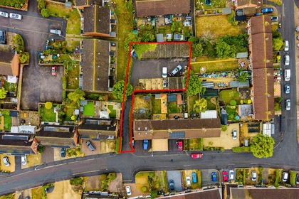
- Price
- Guide Price£40,000
- Size
- 0.14 acres
11 Garages | Brockworth, Brockworth, Gloucestershire GL3 England
Added on 05/10/2026Development Land
- Price
- Offers Over£30,000
Penygraig Terrace, Ynysybwl, Pontypridd, Ynysybwl and Coed-y-cwm, Rhondda Cynon Taf CF37 Wales
Added on 29/01/2026Small Plot of Land