Barns At Witton Old Hall, Witton, North Walsham, Norfolk, NR28
- Land size
- 0.7 acres
Key Features
- Available as a Whole or in Two Lots
- Full Planning Permission
Description
Available as a Whole or in Two Lots
Full Planning Permission
Old Hall Farm Barns at Witton offers a pair of traditional brick and flint barns with planning permission implemented for their conversion to two, four bedroom single storey residences.
Available as a Whole (£400,000) or in two lots (£200,000 each).
Please note VAT may be payable in addition.
Detailed Description
LOCATION
Old Hall Farm Barns are located in North East Norfolk, approximately three miles east of the market town of North Walsham. The town offers a range of facilities and services including three supermarkets, a range of sports facilities, shops, restaurants and infant, junior and high schools. Approximately five miles north and twelve miles north east are the popular coastal destinations of Mundesley and Cromer. The cathedral city of Norwich is 18 miles to the south west providing more extensive facilities including direct rail connections to London and an international airport.
Sitting in close proximity to both The Broads National Park and the North Norfolk Coast Area of Outstanding Natural Beauty, the property itself occupies a rural position, away from the road.
DESCRIPTION
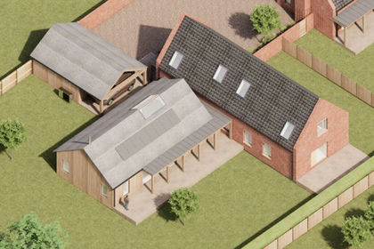
This residential development site extends to approximately 0.70 acres and offers a unique opportunity to acquire two traditional farm buildings with full, implemented planning permission for conversion into two dwellings. The barns are available as a whole or can be split into two lots, as shown on the indicative sale plan. Set within an attractive rural location, these barns combine historic charm and excellent development potential suited to modern living. The property also benefits from the security of near neighbours.
PLANNING PERMISSION
The Cart Shed Barn (Unit 2) is a single-storey traditional farm building with red brick and flint walls, open bays with exposed timber frames on the east side, and a clay pantile roof. Planning permission has been granted for conversion into a four-bedroom single storey dwelling covering 2,090 sqft. The proposed layout includes four double bedrooms, three being ensuite, with a further family bathroom, utility room and open plan kitchen and living space. The barn frontage makes the most of the attractive outlook across rolling farmland.
The Former Dairy Barn (Unit 11/13A) is made up of two attached buildings. Unit 11 is a single storey traditional redbrick and flint barn that boasts high eaves, with an open bay on the south facing side, and a clay pantile roof. Unit 13A, is a single-storey former dairy building, that is a more modern addition with a corrugated tin and fibre cement roof. Planning permission allows for conversion into a 2,882.50 sqft four-bedroom single storey dwelling. The proposed layout houses kitchen and living areas within Unit 11 with an entrance hall connecting to Unit 13A where there are four double bedrooms, including two ensuite, as well as a further bathroom, separate WC, home office and utility room.
Outside, both properties have ancillary land to provide parking, landscaping and garden space.
Full planning details can be found on the North Norfolk District Council website, under reference number: PF/15/1524. The planning permission was obtained in October 2017 and has been successfully implemented by the installation of access to the south and the discharging of ecology and landscaping conditions with approved plans (ref: CDA/15/1524).
Important Planning Notes: An application to make a non material amendment to remove the door on the western boundary of Unit 13 is in progress. The sunroom on Unit 11 included in the planning permission is not to be constructed. The buyer will be responsible for making any relevant planning amendments to remove this feature.
These changes are both shown on the illustrative plans in the sale brochure. Please refer to the Sellers' Agent for more information or further clarification.
GENERAL REMARKS AND STIPULATIONS
SERVICES
The wider farmyard has mains electrical and water connections. Interested parties should make their own enquiries of the relevant authorities regarding the connection, capacity, adequacy and availability of all services for their intended use. It will be the Buyer's obligation to undertake separation works to these connections as required and to facilitate rainwater and foul water drainage as required.
VAT
Please note that the property is opted to tax. A VAT registered Buyer will be required to pay VAT on the purchase price. For non VAT registered buyers who are unable to reclaim the VAT there is an ability to disapply the option. Please speak to the Selling Agents for more information.
VIEWINGS
Strictly by appointment with Brown & Co. Please contact: Lulu Agnew or Ben Taylor
METHOD OF SALE
For Sale by Private Treaty together as a whole development site, or split into two separate sites in accordance with the indicative sale plan.
OVERAGE/COVENANTS
A Covenant will apply, limiting the number of units developed on site to the number specified in the existing planning permission.
Should the Buyer of Unit 11 amend the internal layout of the property so that visibility from the window on the western elevation overlooks the adjoining farmhouse, they will be required to install obscure glass to ensure privacy.
WAYLEAVES, EASEMENTS & RIGHTS OF WAY
The sale is subject to all rights of support, public and private rights of way, water, light, drainage and other easements, quasi-easements and wayleaves, all or any other like rights, whether mentioned in these particulars or not. In particular;
- The Seller will retain the freehold of the driveway and access. The relevant rights of access to the property from the public highway will be included as part of the sale. The buyer(s) will be responsible for a fair and reasonable proportion (according to user) of costs of repair, maintenance and replacement of shared access.
- The Seller will retain rights to access rainwater and foul water pipes serving The Old Hall for repair, maintenance and replacement.
TENURE AND POSSESSION
The Freehold is for sale with Vacant Possession. Additional curtilage land shown hatched brown on the sale plan could be available to a buyer subject to separate negotiation.
BOUNDARY OBLIGATIONS
The Buyer will be responsible for fencing the boundaries within 6 months from the date of completion. The exact positioning of boundaries will be agreed once a sale is agreed between the parties on site.
DISPUTES
Should any dispute arise as to the boundaries or any point arising in the General Remarks and Stipulations or particulars of sale, schedules, plans or interpretation of any of them, the matter shall be referred to an Arbitrator to be appointed by the Selling Agents. The Buyer(s) shall be deemed to have full knowledge of all boundaries and neither the Seller nor Selling Agents will be responsible for defining boundaries or the ownership thereof.
HEALTH & SAFETY
The property is part of a working farm and therefore Viewers should be careful and vigilant whilst on the property. Neither the Vendors nor the Vendors' Agents are responsible for the safety of those viewing the property and accordingly those viewing the property do so at their own risk.
ANTI MONEY LAUNDERING
In accordance with the most recent Anti Money Laundering Legislation, Buyer(s) will be required to provide proof of identity and address to the Vendors' Agents once an offer has been submitted and accepted (subject to contract) prior to Solicitors being instructed.
Map Location
Property details
- Tenure
- Freehold
- Council Tax Band
- Ask Agent
- Date Posted
- 2026-10-12
Utilities & Restrictions
Utilities
- Electricity
- Ask Agent
- Water
- Ask Agent
- Heating
- Ask Agent
- Broadband
- Ask Agent
- Sewerage
- Ask Agent
Rights & Restrictions
- Public Rights of Way
- Ask Agent
- Private Rights of Way
- Ask Agent
- Listed Property
- Ask Agent
- Restrictions
- Ask Agent
Listed status, conservation areas and planning constraints for this location are in the full report.
Property Features
- Accessibility
- Ask Agent
- Parking
- Ask Agent
- Garden
- Ask Agent
Beyond the particulars: planning activity, flood history, heritage and ground risks, checked for this exact spot.
Connectivity
Broadband
Fastest speed available at this postcode
1.8 Gbps
Gigabit full fibre
Suitable for
- 4K streaming on every screen
- Full-time home working
- Online gaming & big downloads
Mobile signal
Predicted 4G and 5G signal; indoor signal depends on building materials.
Ofcom Connected Nations postcode-level predictions. Speeds and signal are modelled, not measured, and vary between addresses and providers.
Signal is the easy part. Planning activity, flood history and protected designations here are in the full report.
Nearest Schools
Primary
- North Walsham Junior School2 milesNo Ofsted rating
- Ages
- 7 to 11
- Pupils
- 248
- Type
- Academy converter
- North Walsham Infant School2 milesOfsted: Good
- Ages
- 4 to 7
- Pupils
- 151
- Type
- Academy converter
- East Ruston Infant School & Nursery2.1 milesOfsted: Good
- Ages
- 2 to 7
- Pupils
- 37
- Type
- Academy converter
- Bacton Primary School2.6 milesOfsted: Good
- Ages
- 2 to 11
- Pupils
- 77
- Type
- Community school
- Worstead Church of England Primary School2.6 milesNo Ofsted rating
- Ages
- 4 to 11
- Pupils
- 106
- Type
- Voluntary aided school
- Faith
- Church of England
Secondary
- North Walsham High School2.1 milesOfsted: Good
- Ages
- 11 to 16
- Pupils
- 641
- Type
- Academy converter
- Stalham High School4.5 milesOfsted: Good
- Ages
- 11 to 16
- Pupils
- 492
- Type
- Academy sponsor led
- Broadland High Ormiston Academy7.2 milesNo Ofsted rating
- Ages
- 11 to 16
- Pupils
- 725
- Type
- Academy converter
- Aylsham High School7.9 milesNo Ofsted rating
- Ages
- 11 to 16
- Pupils
- 1,138
- Type
- Foundation school
- Cromer Academy9.2 milesNo Ofsted rating
- Ages
- 11 to 16
- Pupils
- 665
- Type
- Academy converter
Distances are straight-line from the advertised location. Source: the national school registers (DfE, Welsh Government, Scottish Government) and Ofsted.
Schools are just the start: sold prices nearby, planning activity and any flood history are in the full report.
Amenities
Supermarket
GP surgery
Pharmacy
Hospital
Straight-line distances from the advertised location. Sources: NHS records, Geolytix supermarket locations, OS Open Greenspace and the national trails registers.
The area stacks up? Now check the location itself: planning nearby, protected designations and past flooding.
Getting Around
Nearest station
Nearest bus stop
Typical drive times
Straight-line distances from the advertised location; drive times are typical free-flow times over OpenStreetMap road data, so allow more at peak. Public transport locations from DfT NaPTAN.
Easy to reach matters. So do planning activity, flood history and ground risks: all in the full report.
Flood Risk
Environment Agency open data, checked around the advertised map pin for the listed acreage. Long-term risk counts flood defences; the planning map's flood zones do not. Provided by LandSale, not the listing agent, and not part of the agent's particulars. Risk varies across a holding, so verify before committing.
Rivers and the sea
Planning map: Flood Zone 1.
Surface water
Not at the pin: mapped about 20 metres away.
These bandings are the summary. Where this location sits on the flood maps, plus planning activity, heritage and ground risks, is in the full report.
Important notice: Information, maps and tags on this page are drawn from the advertising agent's marketing materials or generated automatically. LandSale has not verified them. Relying on these details is at your own risk, always carry out independent checks before committing to a purchase.
LandSale full disclaimer
Marketing information only - not formal particulars. The details on this website are provided for general guidance and do not constitute an offer or contract. Neither LandSale nor the advertising estate/land agent accepts responsibility for any inaccuracy.
1. Source of information
- Listing content: Core description, asking price, tenure, measurements, photographs and planning history originate from the marketing materials of the advertising estate or land agent. LandSale does not author this content and cannot guarantee its accuracy.
- Automated tags & categorisation: Property type, land-use class, acreage bands and similar labels may be applied by machine-learning models. They are intended as a helpful guide only and may not reflect the property's legal status or permitted use.
- Third-party & enriched data layers: Maps, boundary outlines, planning designations, soil reports, broadband coverage and other environmental or location-based insights are licensed from external suppliers. Such data are supplied “as is", may be incomplete or out of date and are subject to change without notice.
2. Verification required
Prospective purchasers must verify critical matters, including but not limited to planning permission, title boundaries, public rights of way, environmental constraints, acreage, services, access and VAT status, through their own inspections, specialist surveys, legal advisers and the selling agent before relying on the information or entering into any contract.
3. No warranty or liability
LandSale gives no warranty, express or implied, as to the accuracy, completeness or fitness for any particular purpose of the information displayed. LandSale shall not be liable for any loss, damage, cost or expense arising directly or indirectly from any use of or reliance on such information, save where liability may not be excluded by law.
4. Updates & feedback
If you believe any detail on this listing is inaccurate, please let us know. We will investigate and, where appropriate, update the listing or notify the agent.
© LandSale | Version 1.3 - August 2026
Listing agent
BROWN & CO-PROPERTY AND BUSINESS CONSULTANTS LLP, King's Lynn
Contact BROWN & CO-PROPERTY AND BUSINESS CONSULTANTS LLP, King's Lynn
View agent profileSimilar properties for sale
- Price
- Guide Price£375,000
Land off Church Loke, Coltishall, Norfolk, Coltishall, Norfolk NR12 England
Added on 14/05/2026Self Build Plot
- Price
- Guide Price£500,000
- Size
- 1 acres
Land for sale, Shortthorn Road, Stratton Strawless, Stratton Strawless, Norfolk NR10 England
Added on 14/04/2026Development Land
- Price
- Guide Price£375,000
Added on 02/10/2026Building Plot
- Price
- Guide Price£400,000
- Size
- 1.69 acres
Added on 17/07/2026Conversion Land
- Price
- Guide Price£300,000
Added on 29/01/2026Development Land
- Price
- £495,000
Bank House, Market Place, Reepham, Norwich, Norfolk, NR10, Reepham, Norfolk NR10 England
Added on 08/04/2026Redevelopment Land
- Price
- Guide Price£400,000
- Size
- 0.11 acres
Ber Street, Norwich, NR1, Norwich South, Norfolk NR1 England
Added on 28/01/2026Development Land
- Price
- Guide Price£485,000
- Size
- 48.28 acres
Added on 26/08/2026Arable Land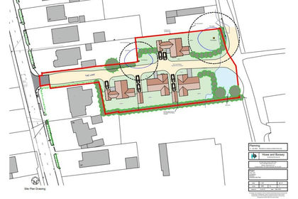
- Price
- Offers Over£450,000
Added on 18/08/2026Building Plot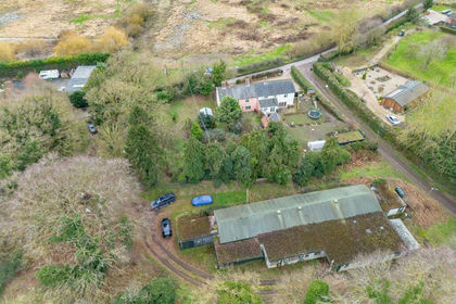
- Price
- Guide Price£450,000
- Size
- 1.22 acres
Development Opportunity in Bawburgh, Bawburgh, Norfolk NR9 England
Added on 22/04/2026Development Land