Friar Waddon, Weymouth
- Land size
- 167.61 acres
Key Features
- 167.61 acres (67.83 hectares)
- Productive Grade 3 arable land
- Ring-fenced block with attractive mixed copse
- Extensive range of agricultural buildings
- Grain store with drying floor and drying system
- Slurry lagoon with an estimated capacity of 2,000 cubic metres
- Central farm track providing good access across the holding
- Private water supply
- Option to purchase additional 103.59 acres of adjoining land
- Potential for future development of a derelict dairy house, subject to planning
Description
An attractive and productive block of arable land with useful range of agricultural buildings. Situated not far from the coastline, enjoying an attractive rural position. With woodland and option to purchase further adjoining land.
Introduction - Corton Farm offers prospective purchasers the opportunity to acquire an attractive and productive ring-fenced block of agricultural land in this sought-after part of Dorset. Extending to approximately 167.61 acres (67.83 ha), the property comprises predominantly Grade 3 arable land together with two areas of mixed copse and a useful range of agricultural buildings.
The farm provides a versatile agricultural holding, with the land being level to gently sloping. A central farm track provides good access throughout the holding, while the rural position boasts attractive views across the surrounding rolling countryside.
The property has historically been used for both arable and livestock enterprises, with the farm buildings providing accommodation suitable for a range of agricultural uses. The holding also has sporting, amenity and potential development interest, including a derelict dairy house occupying an elevated position within the southernmost parcel, which may offer future development potential subject to the necessary planning permission.
There is further potential to expand the holding with a pre-agreed option over 103.59 acres of adjoining land.
Situation - Corton Farm is situated in the small hamlet of Friar Waddon, between the picturesque village of Portesham to the west and Upwey to the east. The property occupies a secluded and attractive rural position, with far-reaching views over the surrounding rolling countryside and is located within easy reach of the spectacular Jurassic Coast World Heritage Site.
The nearby towns of Dorchester and Weymouth provide an extensive range of retail, recreational and commercial facilities, together with mainline railway connections. The A35 is also within easy reach.
Directions - From Dorchester, take the A35 west towards Bridport. At Monkeys Jump Roundabout take the exit signposted Martinstown, onto Bridport Road. Proceed for approximately 1.4 miles before turning left onto the B3159 towards Upwey. Continue for approximately 2.4 miles before turning right onto Friar Waddon Road. After approximately 1.6 miles, the access to Corton Farm will be found on the left-hand side.
What3Words: ///handbook.outwards.interrupt
The Land - Corton Farm comprises approximately 167.61 acres (67.83 ha) of productive, ring-fenced arable land together with two areas of attractive mixed copse. The land is classified as Grade 3 on the Agricultural Land Classification Map. An old railway line also runs east to west through the centre of the farm.
The land provides a useful block for arable and mixed farming enterprises and benefits from its accessible configuration.
The derelict dairy house occupies an elevated position within the centre of the southernmost parcel. This former building may offer future development potential, subject to obtaining the necessary planning permission.
The property benefits from a pre agreed option to purchase the adjoining land extending to 103.59 acres (41.92 hectares), as shown hatched on the sale plan. The option is triggered by the earlier of 2031 or other circumstances relating to the previous owners. The option must be exercised within 6 months of said date. The transfer and price mechanism for the purchase is pre agreed at an index linked average sale price per acre. This option provides purchasers the opportunity to create and expand the holding should the purchaser have the desire to do so. Further details are available from the selling agents.
Farm Buildings - Corton Farm benefits from a useful range of agricultural buildings, providing accommodation suitable for livestock and arable enterprises and arranged around a concrete yard.
The buildings include livestock housing and straw storage, a further livestock housing building with covered yard, a Nissen store, chemical and water storage, a four-bay grain store incorporating a drying floor and drying system, a farm office and a slurry lagoon with an estimated capacity of approximately 2,000 cubic metres.
Some of the buildings were previously used in connection with the breeding and finishing of pigs.
Tenure And Possession - The property is offered for sale Freehold, subject to a cropping licence on the arable land ending on the earlier of either 30th September 2027, or completion of the arable harvest 2027.
Services - The property benefits from a private water supply from a neighbouring property. The purchaser will be responsible for paying for all water consumed.
Rights are also included to cross neighbouring land to the nearest mains water supply connection.
Sporting, Timber And Minerals - The sporting rights, together with the timber and mineral rights, are included in the sale insofar as they are owned by the Vendor.
Public Rights Of Way And Public Access - Access to Corton Farm is directly from the public highway and then over a shared right of access. The purchaser is required to make a contribution towards the upkeep and maintenance of the surface of the shared access.
Public footpaths cross the property. Purchasers should make their own enquiries with the relevant authorities regarding the precise routes and extent of the public rights of way.
National Grid has a right of access along the shared trackway. Further details of the rights of access and associated arrangements are available from the selling agents.
Rural Grant Schemes - The land is not subject to any Rural Grant Funding agreements or schemes.
Designations - Part of the property is located within the Dorset National Landscape.
Part of Dairy House Coppice is designated as Ancient Semi-Natural Woodland.
The property is not located within a Nitrate Vulnerable Zone.
Local Authority - Dorset Council
Tel:
Agents Notes - Some of the land has in recent years been considered and identified as potentially suitable for solar development. Part of the property is subject to an overage provision to a previous owner that expires in January 2031. The overage is only relevant should the specific developer enter into a solar lease on the property. Any different schemes with a different provider would not trigger the overage. Further details are available from the selling agents.
Included in the sale is a significant amount of crushed local stone.
Early entry may be permitted if appropriate for the purchaser to conduct tillages and sow crops at their own risk and cost.
Photos taken in 2023 and 2026.
Map Location
Property details
- Tenure
- Freehold
- Council Tax Band
- Ask Agent
- Date Posted
- 2026-10-06
Market Value Analysis
Compared with 20 Farms & Smallholdings listings in South West England (100+ acres).
Utilities & Restrictions
Utilities
- Electricity
- Ask Agent
- Water
- Mains
- Heating
- Ask Agent
- Broadband
- Ask Agent
- Sewerage
- Ask Agent
Rights & Restrictions
- Public Rights of Way
- Ask Agent
- Private Rights of Way
- Ask Agent
- Listed Property
- Ask Agent
- Restrictions
- Ask Agent
Listed status, conservation areas and planning constraints for this location are in the full report.
Property Features
- Accessibility
- Ask Agent
- Parking
- Ask Agent
- Garden
- Garden
Beyond the particulars: planning activity, flood history, heritage and ground risks, checked for this exact spot.
Connectivity
Broadband
Fastest speed available at this postcode
27 Mbps
Standard (10-30 Mbps)
Suitable for
- Web & social
- Music streaming
- Standard video calls
Mobile signal
Predicted 4G and 5G signal; indoor signal depends on building materials.
Ofcom Connected Nations postcode-level predictions. Speeds and signal are modelled, not measured, and vary between addresses and providers.
Signal is the easy part. Planning activity, flood history and protected designations here are in the full report.
Nearest Schools
Primary
- Portesham Church of England Primary School2.2 milesOfsted: Good *
- Ages
- 4 to 11
- Pupils
- 46
- Type
- Academy sponsor led
- Faith
- Church of England
- St Nicholas and St Laurence Church of England Primary School2.7 milesOfsted: Good *
- Ages
- 4 to 11
- Pupils
- 213
- Type
- Academy converter
- Faith
- Church of England
- Winterbourne Valley Church of England Aided First School3.1 milesOfsted report card · Jan 2026
- Ages
- 3 to 9
- Pupils
- 60
- Type
- Voluntary aided school
- Faith
- Church of England
- Radipole Primary School3.2 milesNo Ofsted rating
- Ages
- 4 to 11
- Pupils
- 437
- Type
- Community school
- Bincombe Valley Primary School3.3 milesOfsted report card · Feb 2026
- Ages
- 2 to 11
- Pupils
- 291
- Type
- Community school
Secondary
- Wey Valley Academy2.7 milesOfsted: Good
- Ages
- 11 to 16
- Pupils
- 994
- Type
- Academy converter
- The Thomas Hardye School3.6 milesOfsted: Good *
- Ages
- 13 to 18
- Pupils
- 2,014
- Type
- Academy converter
- Dorchester Middle School3.8 milesOfsted report card · Jun 2026
- Ages
- 9 to 13
- Pupils
- 527
- Type
- Academy converter
- Budmouth Academy Weymouth4.2 milesOfsted: Requires improvement
- Ages
- 11 to 18
- Pupils
- 1,466
- Type
- Academy sponsor led
- St Osmund's Church of England Middle School4.2 milesOfsted: Good
- Ages
- 9 to 13
- Pupils
- 714
- Type
- Academy converter
- Faith
- Church of England
* Latest graded judgement covers quality of education only; no overall grade was issued under the 2024-25 inspection framework.
Distances are straight-line from the advertised location. Source: the national school registers (DfE, Welsh Government, Scottish Government) and Ofsted.
Schools are just the start: sold prices nearby, planning activity and any flood history are in the full report.
Amenities
Supermarket
GP surgery
Pharmacy
Hospital
Walking trail
Straight-line distances from the advertised location. Sources: NHS records, Geolytix supermarket locations, OS Open Greenspace and the national trails registers.
The area stacks up? Now check the location itself: planning nearby, protected designations and past flooding.
Getting Around
Nearest station
Nearest bus stop
Typical drive times
Straight-line distances from the advertised location; drive times are typical free-flow times over OpenStreetMap road data, so allow more at peak. Public transport locations from DfT NaPTAN.
Easy to reach matters. So do planning activity, flood history and ground risks: all in the full report.
Flood Risk
Environment Agency open data, checked around the advertised map pin for the listed acreage. Long-term risk counts flood defences; the planning map's flood zones do not. Provided by LandSale, not the listing agent, and not part of the agent's particulars. Risk varies across a holding, so verify before committing.
Rivers and the sea
Planning map: Flood Zone 1.
Surface water
Not at the pin: mapped about 40 metres away.
These bandings are the summary. Where this location sits on the flood maps, plus planning activity, heritage and ground risks, is in the full report.
Important notice: Information, maps and tags on this page are drawn from the advertising agent's marketing materials or generated automatically. LandSale has not verified them. Relying on these details is at your own risk, always carry out independent checks before committing to a purchase.
LandSale full disclaimer
Marketing information only - not formal particulars. The details on this website are provided for general guidance and do not constitute an offer or contract. Neither LandSale nor the advertising estate/land agent accepts responsibility for any inaccuracy.
1. Source of information
- Listing content: Core description, asking price, tenure, measurements, photographs and planning history originate from the marketing materials of the advertising estate or land agent. LandSale does not author this content and cannot guarantee its accuracy.
- Automated tags & categorisation: Property type, land-use class, acreage bands and similar labels may be applied by machine-learning models. They are intended as a helpful guide only and may not reflect the property's legal status or permitted use.
- Third-party & enriched data layers: Maps, boundary outlines, planning designations, soil reports, broadband coverage and other environmental or location-based insights are licensed from external suppliers. Such data are supplied “as is", may be incomplete or out of date and are subject to change without notice.
2. Verification required
Prospective purchasers must verify critical matters, including but not limited to planning permission, title boundaries, public rights of way, environmental constraints, acreage, services, access and VAT status, through their own inspections, specialist surveys, legal advisers and the selling agent before relying on the information or entering into any contract.
3. No warranty or liability
LandSale gives no warranty, express or implied, as to the accuracy, completeness or fitness for any particular purpose of the information displayed. LandSale shall not be liable for any loss, damage, cost or expense arising directly or indirectly from any use of or reliance on such information, save where liability may not be excluded by law.
4. Updates & feedback
If you believe any detail on this listing is inaccurate, please let us know. We will investigate and, where appropriate, update the listing or notify the agent.
© LandSale | Version 1.3 - August 2026
Listing agent
Symonds & Sampson, Dorchester
9 Weymouth Avenue Brewery Square, Dorchester DT1 1QR
Contact Symonds & Sampson, Dorchester
9 Weymouth Avenue Brewery Square, Dorchester DT1 1QR
View agent profileSimilar properties for sale
- Price
- Guide Price£1,300,000
- Size
- 134.07 acres
Coombe Road, Winterbourne Steepleton, Dorchester, Winterbourne Steepleton, Dorset DT2 England
Added on 06/10/2026Farmland
- Price
- Offers in Excess of£2,250,000
- Size
- 11.66 acres
Added on 29/01/2026Commercial Land
- Price
- Guide Price£1,750,000
- Size
- 6.21 acres
Land at Beavers Lodge Farm, Lympsham Road, BS24, Lympsham, Somerset BS24 England
Added on 29/01/2026Development Land
- Price
- Guide Price£1,200,000
- Size
- 2.5 acres
Added on 29/01/2026Redevelopment Land
- Price
- Guide Price£1,400,000
- Size
- 24 acres
Woodmancote, West Sussex, Westbourne, West Sussex PO10 England
Added on 06/02/2026Building Plot
- Price
- £1,400,000
- Size
- 149.37 acres
Added on 17/06/2026Farmland
- Price
- £1,500,000
- Size
- 228 acres
Llanfoist, Abergavenny., Llanfoist Fawr, Monmouthshire NP7 Wales
Added on 11/05/2026Farmland
- Price
- Guide Price£1,400,000
- Size
- 141.4 acres
Added on 04/06/2026Farm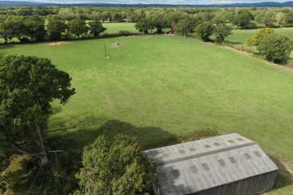
- Price
- Guide Price£1,300,000
- Size
- 64 acres
Skiff Lane, Wisborough Green, RH14, Loxwood, West Sussex RH14 England
Added on 17/09/2026Conversion Land