Llanddewi Brefi, Tregaron
- Bathrooms
- 1
Key Features
- Best and final offers to be submitted by 12 noon on the 9th of October 2026
- Detached former church hall
- Ripe for renovation and refurbishment
- Set in a village location
- Ideal spot for creative projects or new ventures
- In a village with a strong sense of community
- Built of solid stone walls
- With an open plan styled accommodation
- Main hall, rear kitchen and ladies and gents toilet
Description
Best and final offers invited by 12 noon the 9th of October 2026.
Nestled in the charming village of Llanddewi Brefi, Tregaron, this unique property presents an exciting opportunity for those with a vision. This detached former church hall is ripe for refurbishment and renovation, offering potential for a variety of uses, subject to the necessary consents.
Set in a central location within the village, the property benefits from a sense of community and accessibility, making it an ideal spot for creative projects or new ventures.
The village of Llanddewi Brefi has a strong community in the foothills of the Cambrian Mountains and is close to Tregaron and Lampeter offering wider amenities.
Best Offers - Taking into account the interest received and our clients charitable status interested parties are invited to submit their best and final offer for the purchase of the property in writing to the selling agents by 12 noon Friday the 9th October 2026.
These should be in a sealed envelope marked "Llanddewi Brefi Church Hall" " or alternatively via email
All offers need to be for a fixed sum and not related to any other offer received.
By entering this process the vendors or their representatives are not obliged to accept the highest or indeed any offer for the purchase of the property and reserve the right not to disclose any offers submitted. All offers submitted are only considered acceptable subject to the Diocese Board of Finance approval
Best offers submissions should include the following.
1. Proof of funding.
2. The intended use and any conditions for the purchase by the purchaser, i.e obtaining planning permission etc.
Location - The property is situated within the rural village of Llanddewi Brefi, a popular and picturesque village nestling in the foothills of the Cambrian Mountains. The village offers a range of local amenities including public houses, village hall and places of worship, whilst the nearby market town of Tregaron provides a wider range of facilities including a modern 3-16 school campus, doctor's surgery, shops, cafés, public houses and leisure amenities. The area is renowned for its attractive countryside, scenic walking and cycling routes, and excellent access to the Cambrian Mountains, making it an appealing location for those seeking a tranquil rural setting whilst remaining within convenient reach of everyday services.
Description - A detached property substantially constructed with solid stone walls under a slated roof, this adaptable building is a former church hall with an open plan styled accommodation having an impressive open vaulted roof structure to the main hall with a rear kitchen and ladies and gents W.Cs
Front Entrance Vestibule - 1.68m x 1.30m (5'6" x 4'3") - Having quarry tile floor, door into -
Main Meeting Room/Public Hall Area - 12.07m x 6.40m (39'7" x 20'11") - An open plan space having an exposed vaulted roof structure with oak trusses, several side windows, timber flooring
Rear Hallway - 3.05m x 1.83m (10' x 6') -
Kitchen Off - 3.05m x 3.05m (10' x 10') - Having basic kitchen units at base level incorporating single drainer sink unit
Gents W.C. - 1.63m x 1.70m (5'4" x 5'7") - With toilet and wash basin
Ladies W.C. - 1.32m x 1.70m (4'4" x 5'7") - With toilet and wash basin
Externally - The property is contained within a stone walled boundary with mainly gravelled curtilage.
Services - It is believed the property benefits from connection to mains electricity, mains water and mains drainage.
Conditions Of Sale - The property is being offered for sale under the vendors normal and standard conditions of sale and will be subject to their usual covenants. A copy of the usual covenants can be provided on request.
Title - The Diocese have made an application to the Land Registry to register the triangular area shown edged red on the attached plan' i.e. it has not yet obtained the registered title. If it is of help, the original conveyance showed the title as being as follows:
Map Location
Property details
- Tenure
- Freehold
- Council Tax Band
- Ask Agent
- Date Posted
- 2026-10-01
Utilities & Restrictions
Utilities
- Electricity
- Ask Agent
- Water
- Ask Agent
- Heating
- Ask Agent
- Broadband
- Ask Agent
- Sewerage
- Ask Agent
Rights & Restrictions
- Public Rights of Way
- Ask Agent
- Private Rights of Way
- Ask Agent
- Listed Property
- Ask Agent
- Restrictions
- Ask Agent
Listed status, conservation areas and planning constraints for this location are in the full report.
Property Features
- Accessibility
- Ask Agent
- Parking
- Ask Agent
- Garden
- Ask Agent
Beyond the particulars: planning activity, flood history, heritage and ground risks, checked for this exact spot.
Connectivity
Broadband
Fastest speed available at this postcode
1.8 Gbps
Gigabit full fibre
Suitable for
- 4K streaming on every screen
- Full-time home working
- Online gaming & big downloads
Mobile signal
Predicted 4G and 5G signal; indoor signal depends on building materials.
Ofcom Connected Nations postcode-level predictions. Speeds and signal are modelled, not measured, and vary between addresses and providers.
Signal is the easy part. Planning activity, flood history and protected designations here are in the full report.
Nearest Schools
Primary
- Ysgol Henry Richard2.8 miles
- Pupils
- 387
- Type
- Middle (ages 3-16)
- Language
- Welsh medium school / provision (including transitional)
- Ysgol Gymunedol Y Dderi3.8 miles
- Pupils
- 99
- Type
- Nursery, Infants & Juniors
- Language
- Welsh medium school / provision (including transitional)
- Ysgol Rhos Helyg3.8 miles
- Pupils
- 55
- Type
- Infants & Juniors
- Language
- Welsh medium school / provision (including transitional)
- Ysgol Bro Pedr7.1 miles
- Pupils
- 967
- Type
- Middle (ages 3-19)
- Language
- Dual language school / provision (Welsh and English) (including transitional)
- Carreg Hirfaen7.1 miles
- Pupils
- 164
- Type
- Nursery, Infants & Juniors
- Language
- Welsh medium school / provision (including transitional)
Secondary
- Ysgol Henry Richard2.8 miles
- Pupils
- 387
- Type
- Middle (ages 3-16)
- Language
- Welsh medium school / provision (including transitional)
- Ysgol Bro Pedr7.1 miles
- Pupils
- 967
- Type
- Middle (ages 3-19)
- Language
- Dual language school / provision (Welsh and English) (including transitional)
- Gyfun Aberaeron Comprehensive13 miles
- Pupils
- 573
- Type
- Secondary (ages 11-19)
- Language
- Welsh medium school / provision (including transitional)
- Ysgol Gyfun Penweddig17 miles
- Pupils
- 587
- Type
- Secondary (ages 11-19)
- Language
- Welsh medium school / provision (including transitional)
- Penglais School17 miles
- Pupils
- 1,120
- Type
- Secondary (ages 11-19)
- Language
- English medium school / provision
Distances are straight-line from the advertised location. Source: the national school registers (DfE, Welsh Government, Scottish Government) and Ofsted.
Schools are just the start: sold prices nearby, planning activity and any flood history are in the full report.
Amenities
Supermarket
GP surgery
Pharmacy
Green space
Straight-line distances from the advertised location. Sources: NHS records, Geolytix supermarket locations, OS Open Greenspace and the national trails registers.
The area stacks up? Now check the location itself: planning nearby, protected designations and past flooding.
Getting Around
Nearest station
Nearest bus stop
Typical drive times
Straight-line distances from the advertised location; drive times are typical free-flow times over OpenStreetMap road data, so allow more at peak. Public transport locations from DfT NaPTAN.
Easy to reach matters. So do planning activity, flood history and ground risks: all in the full report.
Flood Risk
Natural Resources Wales open data, checked around the advertised map pin for the listed acreage. Long-term risk counts flood defences; the planning map's flood zones do not. The map pin for this listing marks the postcode area rather than the exact location, so these readings describe the surrounding area. Provided by LandSale, not the listing agent, and not part of the agent's particulars. Risk varies across a holding, so verify before committing.
Rivers and the sea
Planning map: Flood Zone 1.
Surface water
Not at the pin: mapped about 10 metres away.
These bandings are the summary. Where this location sits on the flood maps, plus planning activity, heritage and ground risks, is in the full report.
Important notice: Information, maps and tags on this page are drawn from the advertising agent's marketing materials or generated automatically. LandSale has not verified them. Relying on these details is at your own risk, always carry out independent checks before committing to a purchase.
LandSale full disclaimer
Marketing information only - not formal particulars. The details on this website are provided for general guidance and do not constitute an offer or contract. Neither LandSale nor the advertising estate/land agent accepts responsibility for any inaccuracy.
1. Source of information
- Listing content: Core description, asking price, tenure, measurements, photographs and planning history originate from the marketing materials of the advertising estate or land agent. LandSale does not author this content and cannot guarantee its accuracy.
- Automated tags & categorisation: Property type, land-use class, acreage bands and similar labels may be applied by machine-learning models. They are intended as a helpful guide only and may not reflect the property's legal status or permitted use.
- Third-party & enriched data layers: Maps, boundary outlines, planning designations, soil reports, broadband coverage and other environmental or location-based insights are licensed from external suppliers. Such data are supplied “as is", may be incomplete or out of date and are subject to change without notice.
2. Verification required
Prospective purchasers must verify critical matters, including but not limited to planning permission, title boundaries, public rights of way, environmental constraints, acreage, services, access and VAT status, through their own inspections, specialist surveys, legal advisers and the selling agent before relying on the information or entering into any contract.
3. No warranty or liability
LandSale gives no warranty, express or implied, as to the accuracy, completeness or fitness for any particular purpose of the information displayed. LandSale shall not be liable for any loss, damage, cost or expense arising directly or indirectly from any use of or reliance on such information, save where liability may not be excluded by law.
4. Updates & feedback
If you believe any detail on this listing is inaccurate, please let us know. We will investigate and, where appropriate, update the listing or notify the agent.
© LandSale | Version 1.3 - August 2026
Listing agent
Evans Bros, Lampeter
39 High Street, Lampeter, SA48 7BB
Similar properties for sale
 Added on 02/10/2026Development Land
 Added on 29/01/2026Woodland
 Added on 29/01/2026Building Plot
- Price
- Guide Price£75,000
- Size
- 0.5 acres
Llanafan, Aberystwyth, SY23, Trawsgoed, Ceredigion SY23 Wales
Added on 29/01/2026Development Land
- Price
- Guide Price£50,000
- Size
- 0.6 acres
Land Llanafan, Aberystwyth, SY23, Trawsgoed, Ceredigion SY23 Wales
Added on 29/01/2026Vacant Land
- Price
- £50,000
- Size
- 0.1 acres
Bro Mydyr, Mydroilyn, Nr Aberaeron, SA48, Llanarth, Ceredigion SA48 Wales
Added on 29/01/2026Development Land
- Price
- Guide Price£50,000
- Size
- 1.7 acres
Added on 25/09/2026Undeveloped Land
- Price
- Offers in Region of£59,950
Land at the former Ty'n Llidiart SY23, Melindwr, Ceredigion SY23 Wales
Added on 29/01/2026Undeveloped Land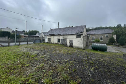
- Price
- Guide Price£75,000
Added on 29/01/2026Development Land Added on 29/01/2026Building Plot