Tredomen, Brecon
- Land size
- 75.9 acres
- Bedrooms
- 3
- Bathrooms
- 1
Key Features
- Characterful three bedroom farmhouse with traditional features
- Approximately 75.90 acres of predominantly Grade 2 & 3 pasture land and mature woodland
- Traditional farm buildings including stables
- Garage and courtyard parking
- Rural location in the pretty hamlet of Tredomen within easy reach od everyday amenities
Description
Middle House Farm is an impressive holding set within the historic hamlet of Tredomen, surrounded by the spectacular scenery of the Bannau Brycheiniog National Park. At its heart lies a
characterful period farmhouse, believed to date from the early 17th century, offering generous accommodation with the opportunity for sympathetic enhancement to create an exceptional
country home.
Extending to approximately 76 acres, the farm comprises productive pasture land, complemented by a small area of broadleaf woodland.
Description - A range of traditional farm buildings and stabling provide excellent versatility for agricultural, equestrian or lifestyle pursuits (subject to the necessary consents), while the attractive gardens and grounds, including an orchard and pond, enhance the property's strong rural appeal. Combining a historic farmhouse, traditional buildings and productive land, Middle House Farm represents a rare opportunity to acquire a compact yet highly attractive holding.
Location - Middle House Farmhouse is situated within the historic hamlet of Tredomen, approximately 4 miles west of the market town of Talgarth and around 7 miles north-east of Brecon, on the outskirts of the Bannau Brycheiniog (Brecon Beacons) National Park. The property enjoys a peaceful rural setting surrounded by unspoilt farmland and rolling countryside, whilst remaining within easy reach of a range of everyday amenities. Talgarth offers independent shops, cafés, public houses, a primary school and healthcare facilities, with a wider selection of retail, educational and leisure services available in Brecon. The area is renowned for its outstanding natural beauty and provides excellent access to the Black Mountains, Hay-on-Wye (approximately 11 miles) and an extensive network of walking, cycling and outdoor recreation opportunities. Tredomen itself is a small historic settlement with origins dating back several centuries, contributing to the character and appeal of this attractive rural location.
Middle House Farmhouse - Middle House Farmhouse is a substantial period residence occupying an idyllic position within the historic hamlet of Tredomen, surrounded by the unspoilt landscapes of the Bannau Brycheiniog National Park. Believed to date from the early 17th century, the property is rich in character and architectural interest, combining traditional stone and rendered elevations beneath a slate roof. The accommodation extends to provide well-proportioned family living space, retaining an abundance of period character throughout. Whilst the interiors would now benefit from a degree of modernisation and sympathetic refurbishment, the property offers an exceptional opportunity to create a distinguished country home, perfectly balancing contemporary comforts with its historic heritage.
The property is approached via a generous courtyard providing ample parking and stone garaging, the farmhouse enjoys attractive gardens and a delightful rural outlook, with views across the surrounding Bannau Brycheiniog National Park and Black Mountains. The accommodation is more particularly described as follows:
Rear Porch - 3.08m x 2.20m (10'1" x 7'2") - With a quarry tiled floor, window overlooking the rear aspect and a door leading through to the principal accommodation.
W/C - 2.15m x 2.03m (7'0" x 6'7" ) - Comprising a wash hand basin and WC, quarry tiled floor, radiator, window to the rear elevation and ceiling hatch to attic space.
Utility - 3.16m x 2.24m (10'4" x 7'4") - With a door and window to the front elevation.
Kitchen/Breakfast Room - 6.61m x 6.37m (max) (21'8" x 20'10" (max)) - With exposed ceiling beams, a solid fuel Rayburn, fitted wall and base units with integrated electric oven and hob, and windows to the front and side elevations. Double doors lead to the side elevation onto a patio area.
Reception Room - 5.67m x 5.59m (18'7" x 18'4" ) - With 16th-century oak floorboards and oak wall panelling, an inglenook fireplace with wood-burning stove and stone overmantel, together with exposed ceiling timbers. A door leads to the front elevation, with windows to both the front and rear elevations.
Sitting Room - 5.59m x 2.74m (18'4" x 8'11") - With exposed oak floorboards and wall panelling, an open fireplace with stone surround and exposed ceiling timbers, together with windows to the front and rear elevations.
Central Hallway - With door to front elevation and staircase rising to the first floor.
Upstairs Hallway - A spacious landing providing access to the bedroom accommodation and family bathroom, with carpet flooring, exposed ceiling timbers and Velux windows.
Main Bedroom - 6.39m x 5.72m (20'11" x 18'9") - With carpet flooring, radiator, built-in wardrobes, together with windows to the front and rear elevations. Double doors open onto a timber balcony, affording views across the surrounding countryside.
Bedroom - 5.71m x 3.50m (18'8" x 11'5") - With carpet flooring, exposed ceiling timbers, vaulted ceiling, feature stone fireplace recess and a window to the front and rear elevation.
Bedroom - 4.87m x 4.08m (max) (15'11" x 13'4" (max)) - With carpet flooring, exposed ceiling timbers, vaulted ceiling with Velux window, wash hand basin and radiator.
Bathroom - Comprising carpet floor with bath, shower, basin and toilet.
Buildings - Middle House Farm benefits from a useful range of traditional farm buildings situated to the north of the farmhouse, together with a separate yard area providing independent access and operational flexibility. In addition, there is a stone-built range adjacent to the farmhouse comprising garaging, stabling and stores, offering excellent ancillary accommodation suitable for a variety of agricultural, equestrian and general storage purposes (subject to the necessary consents).
Traditional Building - Comprising an L-shaped traditional farm building of stone and block construction beneath a corrugated sheet roof. Historically utilised for livestock housing and general storage, the buildings benefit from independent access directly from the council-maintained road via a separate yard area. Offering considerable versatility, the range presents potential for a variety of agricultural, equestrian, commercial or alternative uses, subject to the necessary consents.
Garage & Stables - A traditional stone-built outbuilding under a slate roof, comprising two stables, a garage with adjoining concrete apron and two useful stores, providing excellent ancillary accommodation for equestrian, agricultural or general storage purposes.
The Land - The land extends to approximately 75.90 acres in total, comprising productive pasture divided into a series of interconnecting field parcels. Classified as predominantly Grade 2 and 3 under the provisional agricultural land classification, the land has been utilised for grazing livestock, offering strong stocking capabilities and secure boundaries formed by mature mixed-species hedgerows and post-and-wire fencing. Access is taken directly from the council-maintained road via the yard to the north of the farmhouse. There is also direct road frontage access into field parcel 0991.
A small area of established woodland enhances both the ecological and visual appeal of the holding. The land provides a versatile opportunity for commercial agriculture, alongside potential for environmental or diversification schemes, subject to the necessary consents.
Energy Performance Certificate - Middle House Farmhouse has an energy performance rating of an F.
Council Tax Band - Middle House Farm is a band G for council tax.
Services - Middle House Farmhouse is connected to mains water, main electricity, propane gas and foul drainage is to a septic tank.
Mobile signal/coverage - Varying coverage available from the following providers: EE, O2, Three, Vodafone.
Access - The property is accessed via the council maintained road known as Green Lane.
Tenure - The property is sold freehold, with vacant possession upon completion.
Designations - The land is sold subject to the Control of Agricultural Pollution (Wales) Regulations, which apply to all agricultural land in Wales.
Wayleaves, Easements & Rights Of Way - The property is sold subject to and with the benefit of all easements, quasi easements, wayleaves, and rights of way whether declared or undeclared. There are public rights of way crossing the land at Middle House Farm.
Timber, Sporting & Mineral Rights - All standing timber, mineral rights or any sporting rights, if owned, are included in the sale of the land.
Boundaries & Fencing - The Purchaser shall be deemed to have full knowledge of the boundaries and neither the Vendors nor their Agents will be responsible for defining any ownership of boundaries, hedges or fences. They will however provide whatever assistance they can to ascertain the ownership of the same.
Mode Of Sale - Middle House Farm is being offered for sale as a whole by Private Treaty. Prospective Purchasers should carry out their own enquiries with Powys County Council and other Authorities before making an offer. All offers should be reported to the selling agents.
Guide Price - Offers in the region of £1,000,000
Planning - No formal planning searches have been undertaken on the land. Full details of the planning history can be found on the local authority website.
Local Authority & Public Utilities - Powys County Council, County Hall, Spa Road East, Llandrindod Wells, Powys, LD1 5LG
Dwr Cymru Welsh Water, Linea, Fortran Road, St Mellons, Cardiff, CF3 0LT
National Grid Electricity Distribution plc, Avonbank, Feeder Road, Bristol, BS2 0TB
Viewing - Viewing strictly by appointment with the selling agent only.
Matthew Nicholls on
Hay-on-Wye Office on
Health & Safety - Prospective Purchasers should take all necessary care when making an inspection including wearing suitable clothing. Viewings are taken solely at the risk of those who view and neither the Agents nor the owners of the property take responsibility for any injury however caused.
Site Plans - The plans included in the sale particulars are for identification purposes only and may have been reduced in scale to assist with printing. Any interested parties should check the Title Plan before proceeding to purchase.
Important Notice - These particulars are set out as a guide only. They are intended to give a fair description of the property but may not be relied upon as a statement or representation of facts. These particulars are produced in good faith but are inevitably subjective and do not form part of any Contract. No persons within Sunderlands have any authority to make or give any representation or warranty whatsoever in relation to the property.
Misinterpretation Act - (a) The property is sold with all faults and defects (if any), whether in good condition or otherwise and neither the Vendors nor Sunderlands 1862 LLP, the Agents for the Vendors, shall be in any way responsible for such faults and defects, or for any statements contained in the particulars of the property prepared by the said Agents.
(b) The purchaser shall be deemed to acknowledge that he has not entered into a contract in reliance on any of the said statements that he has satisfied himself, as to the contents of each of the said statements by inspection or otherwise, and that no warranty or representation has been made by the Vendors or the said Agents in relation to, or in connection with the property.
(c) Any error, omission or misstatement in any of the said statements shall not entitle the purchaser to rescind or to be discharged from this contract, nor give either party any cause for action.
(d) All measurements and distances are approximate. The services have not been tested by the Agents. (The normal enquiry is carried out by the purchaser’s Solicitors and the type of inspection undertaken by a purchaser’s surveyor have not been carried out by the selling agents for the purchase or preparation of these particulars). Interested prospective purchasers are recommended to obtain an independent survey report on this property.
Directions - From Hay-on-Wye, proceed south on the A438 towards Brecon for approximately 5 miles before turning right signposted Talgarth. Continue into Talgarth and, upon leaving the town, follow the minor road signposted towards Tredomen. Continue for approximately 1.5 miles into the hamlet of Tredomen, where Middle House Farm will be found within the village.
What3words ///relieves.else.kite
Map Location
Property details
- Tenure
- Freehold
- Council Tax Band
- G
- Date Posted
- 2026-09-30
Market Value Analysis
Compared with 58 Farms & Smallholdings listings in Wales (75+ acres).
Energy Performance Certificate
Energy Efficiency Rating
Based on UK Energy Performance Certificate standards (EU Directive 2002/91/EC)
Running costs are one side. Planning activity, flood history and ground risks for this location are in the full report.
Utilities & Restrictions
Utilities
- Electricity
- Mains
- Water
- Mains
- Heating
- Gas Heating
- Broadband
- Ask Agent
- Sewerage
- Septic Tank / Private
Rights & Restrictions
- Public Rights of Way
- Ask Agent
- Private Rights of Way
- Ask Agent
- Listed Property
- Ask Agent
- Restrictions
- Ask Agent
Listed status, conservation areas and planning constraints for this location are in the full report.
Property Features
- Accessibility
- Ask Agent
- Parking
- Parking Available
- Garden
- Garden
Beyond the particulars: planning activity, flood history, heritage and ground risks, checked for this exact spot.
Connectivity
Broadband
Fastest speed available at this postcode
1.8 Gbps
Gigabit full fibre · available to 90% of premises
Suitable for
- 4K streaming on every screen
- Full-time home working
- Online gaming & big downloads
Mobile signal
Predicted 4G and 5G signal; indoor signal depends on building materials.
Ofcom Connected Nations postcode-level predictions. Speeds and signal are modelled, not measured, and vary between addresses and providers.
Signal is the easy part. Planning activity, flood history and protected designations here are in the full report.
Nearest Schools
Primary
- Llangors C.I.W. School2.6 miles
- Pupils
- 141
- Type
- Nursery, Infants & Juniors
- Language
- English medium school / provision
- Ysgol Y Mynydd Du2.7 miles
- Pupils
- 91
- Type
- Nursery, Infants & Juniors
- Language
- English medium school / provision
- Archdeacon Griffiths C.I.W. Primary School4.3 miles
- Pupils
- 135
- Type
- Nursery, Infants & Juniors
- Language
- English medium school / provision
- Ysgol Y Bannau4.5 miles
- Pupils
- 94
- Type
- Nursery, Infants & Juniors
- Language
- Welsh medium school / provision (including transitional)
- Priory Church In Wales School5 miles
- Pupils
- 143
- Type
- Nursery, Infants & Juniors
- Language
- English medium school / provision
Secondary
- Brecon High School4.7 miles
- Pupils
- 557
- Type
- Secondary (ages 11-19)
- Language
- English medium school / provision
- Gwernyfed High School4.9 miles
- Pupils
- 505
- Type
- Secondary (ages 11-19)
- Language
- English medium school / provision
- Crickhowell High School10 miles
- Pupils
- 942
- Type
- Secondary (ages 11-19)
- Language
- English medium school / provision
- Brynmawr Foundation School13 miles
- Pupils
- 569
- Type
- Secondary (ages 11-16)
- Language
- English medium school / provision
- Ysgol Calon Cymru13 miles
- Pupils
- 948
- Type
- Secondary (ages 11-19)
- Language
- Dual language school / provision (Welsh and English) (including transitional)
Distances are straight-line from the advertised location. Source: the national school registers (DfE, Welsh Government, Scottish Government) and Ofsted.
Schools are just the start: sold prices nearby, planning activity and any flood history are in the full report.
Amenities
Supermarket
GP surgery
Pharmacy
Straight-line distances from the advertised location. Sources: NHS records, Geolytix supermarket locations, OS Open Greenspace and the national trails registers.
The area stacks up? Now check the location itself: planning nearby, protected designations and past flooding.
Getting Around
Nearest station
Nearest bus stop
Typical drive times
Straight-line distances from the advertised location; drive times are typical free-flow times over OpenStreetMap road data, so allow more at peak. Public transport locations from DfT NaPTAN.
Easy to reach matters. So do planning activity, flood history and ground risks: all in the full report.
Flood Risk
Natural Resources Wales open data, checked around the advertised map pin for the listed acreage. Long-term risk counts flood defences; the planning map's flood zones do not. Provided by LandSale, not the listing agent, and not part of the agent's particulars. Risk varies across a holding, so verify before committing.
Rivers and the sea
Planning map: Flood Zone 1.
Surface water
Not at the pin: mapped about 10 metres away.
These bandings are the summary. Where this location sits on the flood maps, plus planning activity, heritage and ground risks, is in the full report.
Important notice: Information, maps and tags on this page are drawn from the advertising agent's marketing materials or generated automatically. LandSale has not verified them. Relying on these details is at your own risk, always carry out independent checks before committing to a purchase.
LandSale full disclaimer
Marketing information only - not formal particulars. The details on this website are provided for general guidance and do not constitute an offer or contract. Neither LandSale nor the advertising estate/land agent accepts responsibility for any inaccuracy.
1. Source of information
- Listing content: Core description, asking price, tenure, measurements, photographs and planning history originate from the marketing materials of the advertising estate or land agent. LandSale does not author this content and cannot guarantee its accuracy.
- Automated tags & categorisation: Property type, land-use class, acreage bands and similar labels may be applied by machine-learning models. They are intended as a helpful guide only and may not reflect the property's legal status or permitted use.
- Third-party & enriched data layers: Maps, boundary outlines, planning designations, soil reports, broadband coverage and other environmental or location-based insights are licensed from external suppliers. Such data are supplied “as is", may be incomplete or out of date and are subject to change without notice.
2. Verification required
Prospective purchasers must verify critical matters, including but not limited to planning permission, title boundaries, public rights of way, environmental constraints, acreage, services, access and VAT status, through their own inspections, specialist surveys, legal advisers and the selling agent before relying on the information or entering into any contract.
3. No warranty or liability
LandSale gives no warranty, express or implied, as to the accuracy, completeness or fitness for any particular purpose of the information displayed. LandSale shall not be liable for any loss, damage, cost or expense arising directly or indirectly from any use of or reliance on such information, save where liability may not be excluded by law.
4. Updates & feedback
If you believe any detail on this listing is inaccurate, please let us know. We will investigate and, where appropriate, update the listing or notify the agent.
© LandSale | Version 1.3 - August 2026
Listing agent
Sunderlands, Hay-on-wye
3 The Pavement, Hay-On-Wye, HR3 5BU
Similar properties for sale
- Price
- Guide Price£875,000
- Size
- 69.32 acres
Added on 13/05/2026Farm
- Price
- Guide Price£900,000
- Size
- 50 acres
Added on 24/04/2026Farm
- Price
- £850,000
- Size
- 56 acres
Halfway, Llandovery, Carmarthenshire., Myddfai, Carmarthenshire SA20 Wales
Added on 28/09/2026House with Land
- Price
- Guide Price£1,000,000
- Size
- 40 acres
Llangovan, Monmouth, Monmouthshire, NP25, Mitchel Troy, Monmouthshire NP25 Wales
Added on 24/05/2026Farm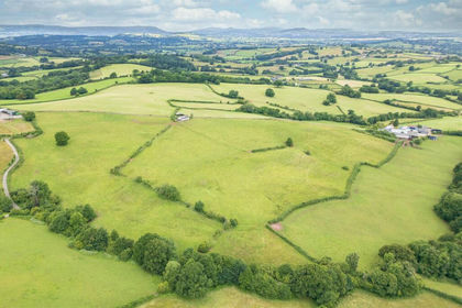
- Price
- Guide Price£1,000,000
- Size
- 116.36 acres
Added on 17/05/2026Farm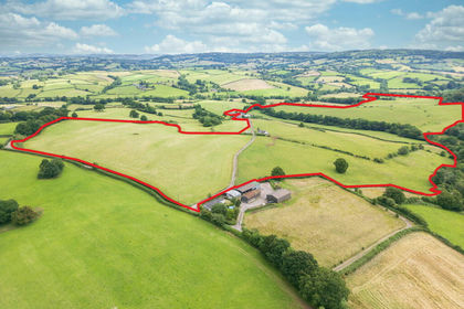
- Price
- Guide Price£1,000,000
- Size
- 116.36 acres
Porthvaynor Farm, Llangwm, Usk, NP15, Devauden, Monmouthshire NP15 Wales
Added on 29/01/2026Farm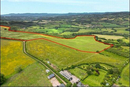
- Price
- Offers in Region of£750,000
- Size
- 67.71 acres
Newchurch, Chepstow, Monmouthshire, NP16, Devauden, Monmouthshire NP16 Wales
Added on 29/01/2026Farm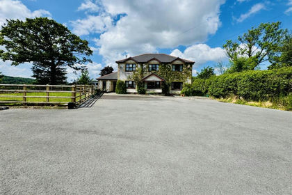
- Price
- Offers in Region of£850,000
- Size
- 56 acres
Added on 26/06/2026Farm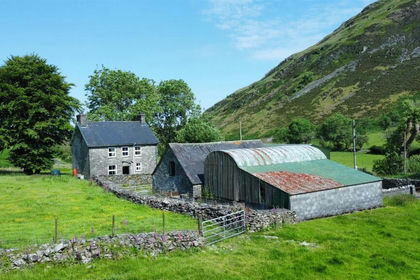
- Price
- Guide Price£1,250,000
- Size
- 210 acres
Added on 29/01/2026Farm
- Price
- Guide Price£1,100,000
- Size
- 97.25 acres
Llwyn-y-Celyn Farm Lot 2, Shirenewton, Chepstow, NP16, Shirenewton, Monmouthshire NP16 Wales
Added on 29/01/2026Dairy Farm