Thorney Hall, Spennithorne, North Yorkshire
- Land size
- 11.1 acres
- Bedrooms
- 6
- Bathrooms
- 4
Key Features
- Historic property.
- Stunning reception rooms
- Amazing views.
- Several staff/guest/holiday cottages/apartments.
- Outbuildings.
- Over 50 acres in total.
- 500 yards of private river fishing.
- No onward chain.
- No listing on the property.
Description
Thorney Hall is a historic North Yorkshire country estate situated on the edge of Spennithorne, just 1.5 miles from Leyburn. Built in 1860 by Lord Bolton for his daughter, it was designed to perfectly align with and overlook Middleham Castle across the dale. The house offers the perfect accommodation with 6 main principle bedrooms and several ancillary bedrooms as well as a separate staff/family flat and 2 guest cottages.
Leyburn 1 ½ miles, Bedale 9 miles, Catterick 11 miles, A1 North (Catterick) 11 miles, A1 South (Bedale) 9 miles, Darlington 25 miles, Northallerton Main Line Train Station 17 miles. Newcastle 59 miles.
Thorney Hall is to be sold in 3 separate lots:
Lot 1 £3,250,000 - Thorney Hall, Grange Cottage, Dairy Cottage and approximately 11.1 acres
Lot 2 £475,000 - Thorney Hall Barn with approximately 1.92 acres
Lot 3 £450,000 - Parcel of land, approximately 43.64 acres
Lord Bolton built the hall as a home for his daughter upon her marriage to a seemingly penniless army captain, Captain Ferrand. He endowed the hall and roughly 800 acres of
farmland to them. The estate was operated as a family farm for the next century. The hall was separated from the farmland in 1960 and sold to the Ministry of Defence, serving as a private residence for the Major General commanding the Catterick Garrison and by the late 1960s, it transitioned into a boutique hotel. During its time as a hotel, the property was used as a filming location in two episodes of the original BBC series of All Creatures Great and Small. Eventually, it transitioned back into private ownership and was split into multiple dwellings. The current owners reunited the property into a single residence and completed an extensive refurbishment program in 2016, restoring it to its original grandeur. It retains remarkable period features, including a cantilevered stone staircase, fossil stone and marble fireplaces, and barrel-vaulted ice houses.
Thorney Hall is currently split into three main parts: the main house (11,620sq ft), which provides extensive accommodation on three levels, including four principal reception rooms, six main bedrooms, four bathrooms and a two-bedroom granny flat; Grange Cottage (2,412sq ft ) on the ground and first floors, comprising two reception rooms, a kitchen, four bedrooms and two bath/shower rooms; Dairy Cottage (1,159sq ft), with a reception hall, sitting room, kitchen/dining room, two bedrooms and two bath/shower rooms on the lower-ground floor. These two cottages are currently successfully let out as holiday cottages
and provide a good income.
The décor of the main house is elegant and understated, with plenty of natural light filtering through large sash windows. An impressive reception hall leads from the front door to the
dual-aspect drawing room, the library with its south-facing bay window, the formal dining room and the kitchen/breakfast room. The six main bedrooms are all arranged on the first floor. In addition to the granny flat, the lower ground floor houses a games room/gym and a snooker room, as well as providing access to four former ice houses with barrel-vaulted stone roofs, which support a stalactite field. The latter is one of many original features, which also include fossil stone and marble fireplaces, window shutters and a cantilevered stone staircase carved from East Witton stone taken from a nearby quarry.
The grounds of Thorney Hall are a delight with mature formal gardens to the front of the house and rambling gardens all around including the delightful arboretum planted around the house at the time of its construction, which today includes some magnificent specimens of Wellingtonia, blue cypress, copper beech and horse chestnut. With its diverse mix of river frontage, 2 small woodlands, water-meadows, pond and lakes, the land is a haven for wildlife, including roe deer and a huge variety of birds includes buzzards, sparrowhawks, barn owls and a breeding colony of swifts.
Land
The 56.5 acres of land are a mix of pastureland, woodland, river frontage, water meadow, lake, pond and a stunning beck which bisects the land below the Hall. c30 acres of the pastureland is let to a local farmer on a FBT until April 2029. The River Ure, which runs by the house, supports otters, salmon, trout and coarse fish, whereas the beck below is an
established breeding ground for Ure salmon. The sale of the property includes 500 yards of single-bank fishing on the River Ure, which forms the southern boundary to Thorney Hall.
Location
The property lies in a picturesque setting on the edge of the small village of Spennithorne, surrounded by beautiful North Yorkshire countryside and within easy reach of the Yorkshire
Dales National Park. Spennithorne, as well as The Hall is located in a conservation area. The village has a community owned local pub, a parish church and a primary school, while everyday amenities are easily accessible in Leyburn, one and a half miles to the west. Leyburn’s facilities include a selection of shops, a medical practice and a small supermarket. Schooling in the area includes an outstanding-rated primary school in Leyburn, a
secondary school also in Leyburn and the independent Aysgarth School and Queen Mary’s. The A1(M) is 9 miles away, providing access towards Leeds and York to the south and Middlesbrough, Sunderland and Newcastle to the north. The National Rail network is close by at Northallerton and provides a regular service down to London or up to Edinburgh. The countryside around Spennithorne is wonderful and perfect for riding and walking with many local attractions on offer including Richard III’s Castle at Middleham and the wonderful ruins of Jervaulx Abby.
There are many good local pubs/hotels in the area including The Blue Lion at East Witton, Swinton Park at Swinton and The Cover Bridge on the River Cover.
Services
Mains water, electricity and drainage. Oil fired boiler for the hot water and central heating. Electricity is also provided by 30 Solar panels in the grounds which reduces the cost of electricity to the main Hall close to zero and provides a small income.
Local Authority
Council tax is payable to Yorkshire Council, band “G”.
Directions
From the village of Spennithorne carry on through the village with the Church on your right towards Leyburn. At the post box (on your right) turn left to Harmby and Leyburn. Leave the
village and after about 100 meters Thorney Hall will be found on the left with the entrance defined by two stone block pillars leading to the main drive.
Tenure and Possession
The property is offered for sale freehold and with vacant possession upon completion. THERE IS NO FORWARD CHAIN.
Viewing
Strictly by prior appointment through Giles Edwards Yorkshire
Property Ltd, Tel: .
Energy Performance
EPC rating is a “C”. Full report available on request.
Map Location
Property details
- Tenure
- Freehold
- Council Tax Band
- Ask Agent
- Date Posted
- 2026-09-23
Market Value Analysis
Compared with 78 Homes with Land listings in Yorkshire and The Humber (10+ acres).
Energy Performance Certificate
View the official EPC certificate for detailed energy efficiency information.
View official EPC certificate ↗
Running costs are one side. Planning activity, flood history and ground risks for this location are in the full report.
Utilities & Restrictions
Utilities
- Electricity
- Mains
- Water
- Mains
- Heating
- Ask Agent
- Broadband
- Standard Copper (ADSL)
- Sewerage
- Mains
Rights & Restrictions
- Public Rights of Way
- Ask Agent
- Private Rights of Way
- Ask Agent
- Listed Property
- Ask Agent
- Restrictions
- Ask Agent
Listed status, conservation areas and planning constraints for this location are in the full report.
Property Features
- Accessibility
- Ask Agent
- Parking
- Secure Parking, Garage, Driveway, Off-Street Parking, EV Charger, Private Parking, Garage En Bloc
- Garden
- Garden
Beyond the particulars: planning activity, flood history, heritage and ground risks, checked for this exact spot.
Connectivity
Broadband
Fastest speed available at this postcode
1.8 Gbps
Gigabit full fibre · available to 33% of premises
Suitable for
- 4K streaming on every screen
- Full-time home working
- Online gaming & big downloads
Mobile signal
Predicted 4G and 5G signal; indoor signal depends on building materials.
Ofcom Connected Nations postcode-level predictions. Speeds and signal are modelled, not measured, and vary between addresses and providers.
Signal is the easy part. Planning activity, flood history and protected designations here are in the full report.
Nearest Schools
Primary
- Spennithorne Church of England Primary School273 metresOfsted: Good
- Ages
- 4 to 11
- Pupils
- 54
- Type
- Voluntary controlled school
- Faith
- Church of England
- Middleham Church of England Aided School1.1 milesOfsted: Good
- Ages
- 4 to 11
- Pupils
- 47
- Type
- Voluntary aided school
- Faith
- Church of England
- Leyburn Primary School1.4 milesOfsted: Good
- Ages
- 3 to 11
- Pupils
- 200
- Type
- Academy converter
- Hunton and Arrathorne Community Primary School4 milesOfsted: Good
- Ages
- 4 to 11
- Pupils
- 86
- Type
- Community school
- Carnagill Community Primary School5.9 milesOfsted: Good *
- Ages
- 3 to 11
- Pupils
- 134
- Type
- Academy sponsor led
Secondary
- Wensleydale School1.5 milesOfsted report card · May 2026
- Ages
- 11 to 16
- Pupils
- 407
- Type
- Community school
- Risedale School6.4 milesOfsted: Requires improvement *
- Ages
- 11 to 16
- Pupils
- 467
- Type
- Community school
- Richmond School & Sixth Form College8 milesOfsted report card · Feb 2026
- Ages
- 11 to 18
- Pupils
- 1,315
- Type
- Academy converter
- St Francis Xavier School - a Joint Catholic and Church of England Voluntary Academy8.3 milesOfsted: Outstanding *
- Ages
- 11 to 16
- Pupils
- 611
- Type
- Academy converter
- Faith
- Roman Catholic/Church of England
- Bedale High School8.3 milesOfsted: Requires improvement
- Ages
- 11 to 16
- Pupils
- 555
- Type
- Community school
* Latest graded judgement covers quality of education only; no overall grade was issued under the 2024-25 inspection framework.
Distances are straight-line from the advertised location. Source: the national school registers (DfE, Welsh Government, Scottish Government) and Ofsted.
Schools are just the start: sold prices nearby, planning activity and any flood history are in the full report.
Amenities
Supermarket
GP surgery
Pharmacy
Hospital
Green space
Straight-line distances from the advertised location. Sources: NHS records, Geolytix supermarket locations, OS Open Greenspace and the national trails registers.
The area stacks up? Now check the location itself: planning nearby, protected designations and past flooding.
Getting Around
Nearest station
Nearest bus stop
Typical drive times
Straight-line distances from the advertised location; drive times are typical free-flow times over OpenStreetMap road data, so allow more at peak. Public transport locations from DfT NaPTAN.
Easy to reach matters. So do planning activity, flood history and ground risks: all in the full report.
Flood Risk
Environment Agency open data, checked around the advertised map pin for the listed acreage. Long-term risk counts flood defences; the planning map's flood zones do not. Provided by LandSale, not the listing agent, and not part of the agent's particulars. Risk varies across a holding, so verify before committing.
Rivers and the sea
Planning map: Flood Zone 2, about 90 metres away.
Surface water
Not at the pin: mapped about 30 metres away.
These bandings are the summary. Where this location sits on the flood maps, plus planning activity, heritage and ground risks, is in the full report.
Important notice: Information, maps and tags on this page are drawn from the advertising agent's marketing materials or generated automatically. LandSale has not verified them. Relying on these details is at your own risk, always carry out independent checks before committing to a purchase.
LandSale full disclaimer
Marketing information only - not formal particulars. The details on this website are provided for general guidance and do not constitute an offer or contract. Neither LandSale nor the advertising estate/land agent accepts responsibility for any inaccuracy.
1. Source of information
- Listing content: Core description, asking price, tenure, measurements, photographs and planning history originate from the marketing materials of the advertising estate or land agent. LandSale does not author this content and cannot guarantee its accuracy.
- Automated tags & categorisation: Property type, land-use class, acreage bands and similar labels may be applied by machine-learning models. They are intended as a helpful guide only and may not reflect the property's legal status or permitted use.
- Third-party & enriched data layers: Maps, boundary outlines, planning designations, soil reports, broadband coverage and other environmental or location-based insights are licensed from external suppliers. Such data are supplied “as is", may be incomplete or out of date and are subject to change without notice.
2. Verification required
Prospective purchasers must verify critical matters, including but not limited to planning permission, title boundaries, public rights of way, environmental constraints, acreage, services, access and VAT status, through their own inspections, specialist surveys, legal advisers and the selling agent before relying on the information or entering into any contract.
3. No warranty or liability
LandSale gives no warranty, express or implied, as to the accuracy, completeness or fitness for any particular purpose of the information displayed. LandSale shall not be liable for any loss, damage, cost or expense arising directly or indirectly from any use of or reliance on such information, save where liability may not be excluded by law.
4. Updates & feedback
If you believe any detail on this listing is inaccurate, please let us know. We will investigate and, where appropriate, update the listing or notify the agent.
© LandSale | Version 1.3 - August 2026
Listing agent
Giles Edwards Yorkshire Property, Masham
4 Market Place, Masham, HG4 4EB
Similar properties for sale
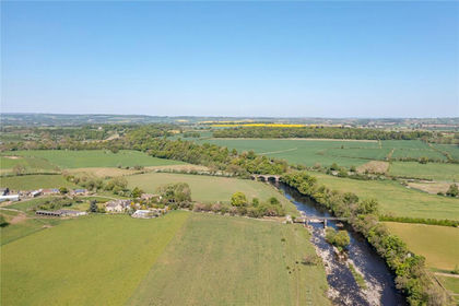
- Price
- Offers Over£3,200,000
- Size
- 134.99 acres
Winston, Richmond, County Durham, DL11, Barforth, County Durham DL11 England
Added on 30/05/2026Country Estate
- Price
- £3,600,000
- Size
- 5 acres
Added on 29/01/2026Country Home
- Price
- £3,600,000
- Size
- 5 acres
Added on 29/01/2026Development Land
- Price
- £2,500,000
- Size
- 7 acres
Heaton house, YO51, Boroughbridge, North Yorkshire YO51 England
Added on 19/04/2026Country Home
- Price
- Guide Price£3,250,000
- Size
- 9 acres
Helperby Manor, Helperby, York, Brafferton and Helperby, North Yorkshire YO61 England
Added on 04/09/2026Country Home
- Price
- Guide Price£3,000,000
- Size
- 11 acres
Osgoodby, Thirsk, Thirkleby High and Low with Osgodby, North Yorkshire YO7 England
Added on 28/06/2026Country Home
- Price
- Guide Price£2,850,000
- Size
- 6.5 acres
Farfield Hall, Addingham, Near Ilkley, West Yorkshire, LS29, Addingham, Bradford LS29 England
Added on 14/04/2026House with Land
- Price
- Guide Price£3,250,000
- Size
- 28 acres
Caydale Mill, Old Byland, York, Old Byland and Scawton, North Yorkshire YO62 England
Added on 24/05/2026House with Land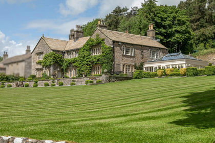
- Price
- Guide Price£2,750,000
- Size
- 7.22 acres
Added on 29/01/2026Stately Home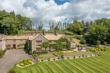
- Price
- £2,750,000
- Size
- 7.22 acres
Added on 29/01/2026Country Estate