North Tawton, EX20
- Bedrooms
- 5
Key Features
- Planning permission for five dwellings
- Traditional stone barn conversions
- Three contemporary new-build homes
- Outstanding rural setting
- Far-reaching countryside views
- Generous gardens, garages & parking
- Freehold site offered as a whole
- Flexible development opportunity
- Alternative purchase structures considered
- Planning references: 3621/21/LBC & 3137/25/FUL
Description
Development opportunities that combine traditional character with contemporary design are becoming increasingly difficult to find, and Westworthy Barns presents exactly that.
Set within a beautiful rural setting surrounded by open Devon countryside, planning permission has been granted to create an attractive scheme of five homes, combining the conversion of traditional agricultural barns with the construction of three contemporary family houses. Whether your intention is to build and sell, retain as an investment or create a bespoke development, the site offers exceptional flexibility.
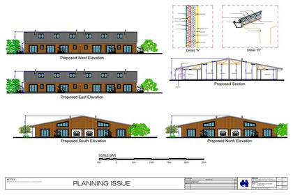
The traditional stone barns, which are curtilage listed, have consent to be sympathetically converted into a pair of attractive two-bedroom single-storey homes arranged around a shared courtyard, retaining the character and heritage of the original buildings whilst creating highly desirable accommodation.
Adjacent to these is a modern agricultural barn with planning permission for demolition and replacement with a terrace of three contemporary three-bedroom homes. Carefully positioned to take advantage of the outstanding countryside views, each property will benefit from generous gardens, private parking and garages, creating an appealing balance between modern living and a rural setting.
Planning permission has been granted under West Devon Borough Council references 3621/21/LBC and 3137/25/FUL, providing purchasers with the opportunity to move forward with an exciting and thoughtfully designed scheme.
The site is offered for sale as a single freehold, although it is currently held under two titles. The seller is also willing to consider alternative purchase structures, including the possibility of retaining the traditional barn conversions and agreeing a bespoke arrangement with a purchaser. Interested parties are encouraged to discuss any proposals with the selling agent.
Opportunities to acquire consented schemes of this quality and flexibility are increasingly rare. Westworthy Barns offers the chance to deliver a distinctive rural development that blends heritage, contemporary design and an exceptional countryside setting.
Please see the floorplan for room sizes.
Current Council Tax: NA – West Devon
Utilities: Unknown
Broadband within this postcode: NA
Drainage: Will be private by buyer
Heating: TBC
Construction: TBC
Listed: The historic barns (2 L-shaped) are listed, the modern barn isn’t.
Conservation Area: No
Tenure: Freehold
Buyers' Compliance Fee Notice: Please note that a compliance check fee of £25 (inc. VAT) per person is payable once your offer is accepted. This non-refundable fee covers essential ID verification and anti-money laundering checks, as required by law.
Agents’ Notes:
Boundaries, Access & Parking:
Boundary positions, access rights and parking arrangements have been provided by the seller, and any land plans shown are for identification purposes only. We have not seen the title deeds or other legal documents, and buyers should confirm exact details and ownership responsibilities with their conveyancer.
Broadband & Mobile Coverage:
Broadband speeds and mobile signal vary by provider and location, and service availability can change over time. Buyers can check current availability and predicted speeds at or via the Ofcom coverage checker.
Digital Photo Enhancement/Virtual Staging:
Some images in this brochure may have been digitally enhanced or virtually staged, for example by adding lighting effects, blue skies, twilight ambience, furniture or décor, to help illustrate how the property could look. These images are only illustrative and do not show the current fixtures, fittings or condition. Always rely on your viewing for an accurate understanding of the property.
NORTH TAWTON is a small market town, the original settlement being alongside the banks of the River Taw around which grew a rich woollen trade. Today the town is home to an array of independent shops and services many of which are centred around the pretty market square with its George V Jubilee clock tower. There are also large employers including Gregory’s Haulage and The Taw Valley Creamery, which also has a cheese shop. Both companies take advantage of North Tawton’s access to a good roadwork, a 6.5 mile drive takes you to the A30. The town is also served by frequent buses with routes to Crediton, Exeter, Okehampton as well as Bideford and Barnstaple. In recent years the town has expanded to accommodate more families as they seek the convenience of a small town within a rural setting, the OFSTED Good primary school is also an attraction. North Tawton has also had its brush with celebrity. The Poet laureate Ted Hughes moved to the town with Sylvia Plath; it remained his home until his passing in 1998. More recently, the town became the fictional village of Clatterford St Mary and the setting for Jennifer Saunders’ sitcom, Jam and Jerusalem.
DIRECTIONS
Use EX20 2DJ or the what3words is ///rather.wakes.unfilled
Map Location
Property details
- Tenure
- Freehold
- Council Tax Band
- Ask Agent
- Date Posted
- 2026-09-23
Utilities & Restrictions
Utilities
- Electricity
- Ask Agent
- Water
- Ask Agent
- Heating
- Ask Agent
- Broadband
- Ask Agent
- Sewerage
- Ask Agent
Rights & Restrictions
- Public Rights of Way
- Ask Agent
- Private Rights of Way
- Ask Agent
- Listed Property
- Ask Agent
- Restrictions
- Ask Agent
Listed status, conservation areas and planning constraints for this location are in the full report.
Property Features
- Accessibility
- Ask Agent
- Parking
- Parking Available
- Garden
- Private Garden
Beyond the particulars: planning activity, flood history, heritage and ground risks, checked for this exact spot.
Connectivity
Broadband
Fastest speed available at this postcode
6 Mbps
Under 10 Mbps here
Suitable for
- Basic browsing & email
Fixed wireless access may also be an option here.
Mobile signal
Predicted 4G and 5G signal; indoor signal depends on building materials.
Ofcom Connected Nations postcode-level predictions. Speeds and signal are modelled, not measured, and vary between addresses and providers.
Signal is the easy part. Planning activity, flood history and protected designations here are in the full report.
Nearest Schools
Primary
- North Tawton Community Primary School and Nursery1.4 milesNo Ofsted rating
- Ages
- 2 to 11
- Pupils
- 160
- Type
- Academy converter
- Bow Community Primary School3.3 milesOfsted: Good *
- Ages
- 4 to 11
- Pupils
- 133
- Type
- Community school
- Winkleigh Primary School3.7 milesOfsted: Good
- Ages
- 0 to 11
- Pupils
- 224
- Type
- Foundation school
- Exbourne Church of England Primary School4.6 milesNo Ofsted rating
- Ages
- 4 to 11
- Pupils
- 25
- Type
- Academy converter
- Faith
- Church of England
- Spreyton School4.7 milesOfsted: Good *
- Ages
- 3 to 11
- Pupils
- 30
- Type
- Foundation school
Secondary
- Chulmleigh Community College6.8 milesNo Ofsted rating
- Ages
- 11 to 16
- Pupils
- 735
- Type
- Academy converter
- Okehampton College7.6 milesOfsted report card · Jan 2026
- Ages
- 11 to 18
- Pupils
- 1,066
- Type
- Academy converter
- Queen Elizabeth's9.7 milesOfsted report card · May 2026
- Ages
- 11 to 18
- Pupils
- 1,096
- Type
- Academy converter
- South Molton Community College14 milesOfsted: Good *
- Ages
- 11 to 16
- Pupils
- 656
- Type
- Foundation school
- Great Torrington School15 milesNo Ofsted rating
- Ages
- 11 to 16
- Pupils
- 863
- Type
- Academy converter
* Latest graded judgement covers quality of education only; no overall grade was issued under the 2024-25 inspection framework.
Distances are straight-line from the advertised location. Source: the national school registers (DfE, Welsh Government, Scottish Government) and Ofsted.
Schools are just the start: sold prices nearby, planning activity and any flood history are in the full report.
Amenities
Supermarket
GP surgery
Pharmacy
Hospital
Straight-line distances from the advertised location. Sources: NHS records, Geolytix supermarket locations, OS Open Greenspace and the national trails registers.
The area stacks up? Now check the location itself: planning nearby, protected designations and past flooding.
Getting Around
Nearest station
Nearest bus stop
Typical drive times
Straight-line distances from the advertised location; drive times are typical free-flow times over OpenStreetMap road data, so allow more at peak. Public transport locations from DfT NaPTAN.
Easy to reach matters. So do planning activity, flood history and ground risks: all in the full report.
Flood Risk
Environment Agency open data, checked around the advertised map pin for the listed acreage. Long-term risk counts flood defences; the planning map's flood zones do not. Provided by LandSale, not the listing agent, and not part of the agent's particulars. Risk varies across a holding, so verify before committing.
Rivers and the sea
Planning map: Flood Zone 1.
Surface water
Not at the pin: mapped about 20 metres away.
These bandings are the summary. Where this location sits on the flood maps, plus planning activity, heritage and ground risks, is in the full report.
Important notice: Information, maps and tags on this page are drawn from the advertising agent's marketing materials or generated automatically. LandSale has not verified them. Relying on these details is at your own risk, always carry out independent checks before committing to a purchase.
LandSale full disclaimer
Marketing information only - not formal particulars. The details on this website are provided for general guidance and do not constitute an offer or contract. Neither LandSale nor the advertising estate/land agent accepts responsibility for any inaccuracy.
1. Source of information
- Listing content: Core description, asking price, tenure, measurements, photographs and planning history originate from the marketing materials of the advertising estate or land agent. LandSale does not author this content and cannot guarantee its accuracy.
- Automated tags & categorisation: Property type, land-use class, acreage bands and similar labels may be applied by machine-learning models. They are intended as a helpful guide only and may not reflect the property's legal status or permitted use.
- Third-party & enriched data layers: Maps, boundary outlines, planning designations, soil reports, broadband coverage and other environmental or location-based insights are licensed from external suppliers. Such data are supplied “as is", may be incomplete or out of date and are subject to change without notice.
2. Verification required
Prospective purchasers must verify critical matters, including but not limited to planning permission, title boundaries, public rights of way, environmental constraints, acreage, services, access and VAT status, through their own inspections, specialist surveys, legal advisers and the selling agent before relying on the information or entering into any contract.
3. No warranty or liability
LandSale gives no warranty, express or implied, as to the accuracy, completeness or fitness for any particular purpose of the information displayed. LandSale shall not be liable for any loss, damage, cost or expense arising directly or indirectly from any use of or reliance on such information, save where liability may not be excluded by law.
4. Updates & feedback
If you believe any detail on this listing is inaccurate, please let us know. We will investigate and, where appropriate, update the listing or notify the agent.
© LandSale | Version 1.3 - August 2026
Listing agent
Helmores, Crediton
111-112 High Street, Crediton, Devon, EX17 3LF
Similar properties for sale
- Price
- From£280,000
Added on 29/01/2026Conversion Land
- Price
- Guide Price£295,000
- Size
- 33.03 acres
Added on 03/07/2026Farm
- Price
- Guide Price£225,000
- Size
- 0.24 acres
42 High Street, St Saviours Way, Crediton, Devon, EX17, Crediton, Devon EX17 England
Added on 29/01/2026Development Land
- Price
- Guide Price£315,000
- Size
- 0.39 acres
Added on 13/08/2026Building Plot
- Price
- £295,000
- Size
- 2.5 acres
Southland Park, Highampton, Beaworthy, Black Torrington, Devon EX21 England
Added on 08/08/2026Development Land
- Price
- Guide Price£275,000
Added on 18/08/2026Development Land
- Price
- Guide Price£275,000
- Size
- 0.5 acres
Added on 25/07/2026Building Plot
- Price
- Guide Price£300,000
Westexe South, Tiverton, Devon, Tiverton, Devon EX16 England
Added on 01/04/2026Development Land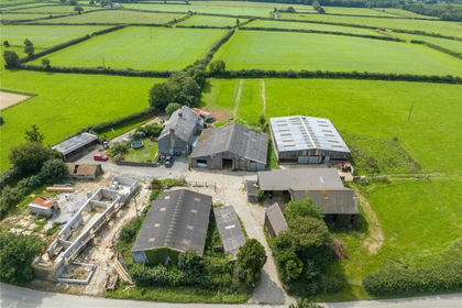 Added on 10/02/2026Building Plot
- Price
- Offers in Region of£250,000
- Size
- 0.59 acres
Youlston Close, Shirwell, Nr. Barnstaple, Devon, EX31, Shirwell, Devon EX31 England
Added on 08/07/2026Building Plot