Upper Senwick, Borgue, Kirkcudbright, DG6
- Land size
- 40.1 acres
- Bedrooms
- 4
- Bathrooms
- 2
Key Features
- Off grid holiday lodge with an established profitable rental return
- 37.25 acres (15.07 Ha) of grazing pasture all located within a ring fence
- Situated in a rural location with views over the rolling countryside and out onto Kirkcudbright Bay
- 3 bedroom cottage offering flexible accommodation
- A range of modern and traditional agricultural buildings
- Potential second income opportunity, with scope to expand and develop the smallholding into a successful holiday let enterprise
- Various consented planning permissions offering potential and scope
Description
Upper Senwick is a smallholding located near the rural town of Dalbeattie, offering excellent potential for diversification into agri-tourism. The property has a diverse array of both residential and agricultural assets offering the purchaser flexibility and an extensive ammount of scope to change a develop the property into the perfect smallholding.
The Accommodation
New Cottage is a detached three bedroom property located at the entrance to the farmyard. The cottage is surrounded by a generous garden and includes a paved patio area with scope for outdoor entertaining or further landscaping. Inside, the property offers a fully fitted kitchen, a bright reception room with bay windows providing plenty of natural light and an open fire that compliments the electric central heating system.
The cottage benefits from mains water, broadband, and a septic tank. The bathroom is fitted with a bath, electric shower, toilet, and sink. A central hallway leads to three double bedrooms, two of which include built-in wardrobes for additional storage.
The Secret Studio is a timber cabin positioned next to the pond, providing attractive rural views and a peaceful setting. The cabin includes a fully equipped bathroom with a bath overlooking the surrounding countryside, as well as a toilet and sink. The open-plan interior features a kitchen, bedroom, and living area centred around a wood-burning stove.
The cabin operates using a solar panel system, providing an environmentally conscious source of power. It also benefits from a fully functioning water supply and a gas-powered hot water system. A network of walking paths surrounds the cabin in the 8 acres of land allowing visitors to enjoy the secluded setting and scenic views. These features make The Secret Studio well suited as a private rural retreat.
Planning Permission
Planning permission has also been granted for the construction of two additional cabins. This presents an opportunity for purchasers looking to expand the property's accommodation or develop an agri-tourism business. Further details of this application can be found on the Dumfries and Galloway Council planning search under the reference 23/0084/FUL.
A further planning permission has been passed to convert the traditional stables into three residential properties. The building is an L-shaped, whitewashed stone outbuilding with a slated roof. Further details can be found on the Dumfries and Galloway Council planning search under the reference 24/1493/FUL.
Prior approval has been sought and a material start has been made on the erection of an agricultural shed measuring 18m x 12m. Further details can be found on the Dumfries and Galloway Council planning search under the reference 22/1828/DPA.
The Steading
The property extends to approximately 40.10 acres (16.23 Ha) and includes a range of agricultural buildings. Planning permission has been granted to convert the traditional stables into three residential properties. The building is an L-shaped whitewashed stone outbuilding with a slated roof.
There is also a modern steel portal frame agricultural building, currently arranged into four sections, providing practical accommodation for livestock and incorporating a central feed passage. In addition the farmyard includes a chicken shed offering potential for a supplementary agricultural or small-scale commercial enterprise.
The Land
The land surrounds the steading and extends approximatly to 37.25 acres (15.07 Ha) excluding the farmstead and cottage and is mainly rough grazing split into four field enclosures. The land benefits from a combination of natural and mains fed water supplies and is all registered with the SGRPID Rural Payments Services.
Situation
Upper Senwick is situated on the western edge of Kirkcudbright Bay, in a rural location, with the nearest town being some 5.5 miles to the North. Kircudbright offers an array of amenties that you would expect of a rural town to include, a supermarket, leisure centre and pharmacy along with various hospitality establishments. The area prides itself on its high quality lifestyle and country pursuits with some of the best shooting, stalkling, fishing and golfing that the county can offer, right on the doorstep of Upper Senwick.
Directions
From the centre of Kirkcudbright head west over the River Dee, and take the first left signposted Borgue. Continue along the coastal road of the B727 for 4 miles taking the first left signposted Brighouse Bay. Follow the road for approximately 1 mile taking the first left, after turning left the property can be found on your left after ¼ of a mile.
What3words:///deeply.sobs.excusing
General Remarks and Stipulations
Viewings: Strictly by appointment through the sole selling agents, C&D Rural. Tel 01228 792299
Tenure and Possession: The Heritable (Scottish equivalent of Freehold) title is offered for sale with vacant possession upon completion.
Matters of Title: The property is sold subject to all existing easements, burdens, reservations and wayleaves, including rights of access and rights of way whether contained in the Title Deeds or informally constituted and whether referred to in the General Remarks and Stipulations or not. The Purchaser(s) will be held to have satisfied themselves as to the nature of such matters. It is understood that the driveway servicing Upper Senwick is under the ownership of the property but has shared access rights with other third parties, with mainatinace being on a per user basis.
Mines & Minerals: All mines and mineral rights are included in so far as they are owned.
Sporting rights: All sporting and fishing rights are included in so far as they are owned by the property.
Council Tax: Dumfries and Galloway Council. Council Tax Band C.
Services: Upper Senwick is served by mains water, mains electricity, private septic tank and electric central heating. Prospective purchasers should make their own enquiries and satisfy themselves as to the condition, compliance and any associated costs. New Cottage has the added benefit of a solar panel array.
BPS: The land is all registered with SGRPID and extends to 13.26 Region 1 entitlements will be included within the sale. For the avoidance of doubt the seller will be retaining the entirety of the 2026 subsidy claim payment.
Money Laundering Obligations: We are required by law to carry out Anti Money Laundering Checks prior to issuing a memorandum of sale. We use an external agency to conduct these checks. Once an offer has been agreed, Coadjute will contact you to complete the checks electronically. A fee of £45 + VAT per person will apply and will be processed by Coadjute. If you have any queries please contact the office.
Plans, Areas and Schedules: These are based on the Ordnance Survey and are for reference only. They have been carefully checked and computed by the selling agents and the purchaser shall be deemed to have satisfied themselves as to the description of the property and any error or mis-statement shall not annul the sale nor entitle either party to compensation in respect thereof.
Website and Social Media: Further details of this property as well as all others offered by C&D Rural are available to view on our website. For updates and the latest properties like us on and Instagram on @cdrural
Referrals: C&D Rural work with preferred providers for the delivery of certain services necessary for a house sale or purchase. Our providers price their products competitively, however you are under no obligation to use their services and may wish to compare them against other providers. Should you choose to utilise them C&D Rural will receive a referral fee.
Map Location
Property details
- Tenure
- Freehold
- Council Tax Band
- C
- Date Posted
- 2026-09-17
Market Value Analysis
Compared with 40 Farms & Smallholdings listings in Scotland (25+ acres).
Energy Performance Certificate
Energy Efficiency Rating
Based on UK Energy Performance Certificate standards (EU Directive 2002/91/EC)
View official EPC certificate ↗
Running costs are one side. Planning activity, flood history and ground risks for this location are in the full report.
Utilities & Restrictions
Utilities
- Electricity
- Ask Agent
- Water
- Direct Main Waters
- Heating
- Electric Central, Solar Panels
- Broadband
- Ask Agent
- Sewerage
- Septic Tank
Rights & Restrictions
- Public Rights of Way
- Ask Agent
- Private Rights of Way
- Ask Agent
- Listed Property
- Ask Agent
- Restrictions
- Ask Agent
Listed status, conservation areas and planning constraints for this location are in the full report.
Property Features
- Accessibility
- Ask Agent
- Parking
- Ask Agent
- Garden
- Ask Agent
Beyond the particulars: planning activity, flood history, heritage and ground risks, checked for this exact spot.
Connectivity
Broadband
Fastest speed available at this postcode
1.8 Gbps
Gigabit full fibre · available to 73% of premises
Suitable for
- 4K streaming on every screen
- Full-time home working
- Online gaming & big downloads
Mobile signal
Outdoor predictions; indoor signal depends on building materials.
Ofcom Connected Nations postcode-level predictions. Speeds and signal are modelled, not measured, and vary between addresses and providers.
Signal is the easy part. Planning activity, flood history and protected designations here are in the full report.
Nearest Schools
Primary
- Borgue School1.7 miles
- Pupils
- 13
- Type
- Non-denominational
- Kirkcudbright Primary School3.1 miles
- Pupils
- 223
- Type
- Non-denominational
- Twynholm School4.7 miles
- Pupils
- 56
- Type
- Non-denominational
- Gatehouse School6.9 miles
- Pupils
- 81
- Type
- Non-denominational
- Auchencairn School9.4 miles
- Pupils
- 31
- Type
- Non-denominational
Secondary
- Kirkcudbright Academy3.1 miles
- Pupils
- 414
- Type
- Non-denominational
- Castle Douglas High School12 miles
- Pupils
- 549
- Type
- Non-denominational
- Dalbeattie High School14 miles
- Pupils
- 347
- Type
- Non-denominational
- Douglas Ewart High School19 miles
- Pupils
- 584
- Type
- Non-denominational
- Dalry Secondary School21 miles
- Pupils
- 21
- Type
- Non-denominational
Distances are straight-line from the advertised location. Source: the national school registers (DfE, Welsh Government, Scottish Government) and Ofsted.
Schools are just the start: planning activity, heritage and any flood history here are in the full report.
Amenities
Supermarket
GP surgery
Pharmacy
Walking trail
Straight-line distances from the advertised location. Sources: NHS records, Geolytix supermarket locations, OS Open Greenspace and the national trails registers.
The area stacks up? Now check the location itself: planning nearby, protected designations and past flooding.
Getting Around
Nearest station
Nearest bus stop
Typical drive times
Straight-line distances from the advertised location; drive times are typical free-flow times over OpenStreetMap road data, so allow more at peak. Public transport locations from DfT NaPTAN.
Easy to reach matters. So do planning activity, flood history and ground risks: all in the full report.
Flood Risk
From SEPA flood map open data, checked around the advertised map pin and allowing for the listed acreage where known. This summary comes from LandSale, the advertising platform, not from the listing agent, and is not part of the agent's particulars. Risk can vary across a single holding, so verify anything critical through your own searches before committing.
Rivers and the sea
Surface water
Mapped within the area searched, not at the advertised map pin itself.
These bandings are the summary. Where this location sits on the flood maps, plus planning activity, heritage and ground risks, is in the full report.
Important notice: Information, maps and tags on this page are drawn from the advertising agent's marketing materials or generated automatically. LandSale has not verified them. Relying on these details is at your own risk, always carry out independent checks before committing to a purchase.
LandSale full disclaimer
Marketing information only - not formal particulars. The details on this website are provided for general guidance and do not constitute an offer or contract. Neither LandSale nor the advertising estate/land agent accepts responsibility for any inaccuracy.
1. Source of information
- Listing content: Core description, asking price, tenure, measurements, photographs and planning history originate from the marketing materials of the advertising estate or land agent. LandSale does not author this content and cannot guarantee its accuracy.
- Automated tags & categorisation: Property type, land-use class, acreage bands and similar labels may be applied by machine-learning models. They are intended as a helpful guide only and may not reflect the property's legal status or permitted use.
- Third-party & enriched data layers: Maps, boundary outlines, planning designations, soil reports, broadband coverage and other environmental or location-based insights are licensed from external suppliers. Such data are supplied “as is", may be incomplete or out of date and are subject to change without notice.
2. Verification required
Prospective purchasers must verify critical matters, including but not limited to planning permission, title boundaries, public rights of way, environmental constraints, acreage, services, access and VAT status, through their own inspections, specialist surveys, legal advisers and the selling agent before relying on the information or entering into any contract.
3. No warranty or liability
LandSale gives no warranty, express or implied, as to the accuracy, completeness or fitness for any particular purpose of the information displayed. LandSale shall not be liable for any loss, damage, cost or expense arising directly or indirectly from any use of or reliance on such information, save where liability may not be excluded by law.
4. Updates & feedback
If you believe any detail on this listing is inaccurate, please let us know. We will investigate and, where appropriate, update the listing or notify the agent.
© LandSale | Version 1.3 - August 2026
Listing agent
C & D Rural, Carlisle
Lakeside, Townfoot, Longtown, Carlisle, CA6 5LY
Similar properties for sale
- Price
- Offers Over£630,000
- Size
- 14.58 acres
Mains of Twynholm, Twynholm, DG6, Dumfries and Galloway, Dumfries and Galloway DG6 Scotland
Added on 02/05/2026Smallholding
- Price
- Offers in Excess of£525,000
- Size
- 7.89 acres
Added on 29/01/2026Smallholding
- Price
- Offers in Excess of£595,000
- Size
- 16.61 acres
Nunland, Lochfoot, Dumfries, DG2, Dumfries and Galloway, Dumfries and Galloway DG2 Scotland
Added on 29/01/2026Cottage
- Price
- Offers Over£295,000
- Size
- 7.81 acres
Drumohr, Terregles, Dumfries, DG2, Dumfries and Galloway, Dumfries and Galloway DG2 Scotland
Added on 04/09/2026Smallholding
- Price
- Offers Over£495,000
- Size
- 4.5 acres
Added on 03/07/2026Smallholding
- Price
- £450,000
- Size
- 45.88 acres
Lot 6 - Prospect Farm, Cockermouth, Cumbria, CA13, Setmurthy, Cumberland CA13 England
Added on 18/08/2026Farmland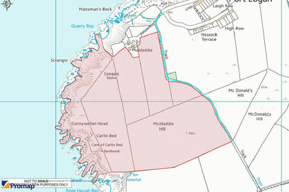
- Price
- Offers in Excess of£450,000
- Size
- 75.76 acres
Land at Muldaddie, Dumfries and Galloway, Dumfries and Galloway DG9 Scotland
Added on 29/01/2026Grazing Land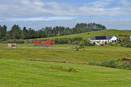
- Price
- Offers Over£340,000
- Size
- 2.76 acres
Added on 15/09/2026Smallholding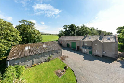
- Price
- Guide Price£575,000
- Size
- 2.31 acres
Woodside House, Waberthwaite, Millom, Cumbria, LA19, Waberthwaite, Cumberland CA18 England
Added on 29/01/2026Farmhouse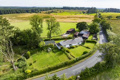
- Price
- Offers in Excess of£425,000
- Size
- 56.42 acres
Sunnyside, Penton, Cumberland, Nicholforest, Cumberland CA6 England
Added on 09/09/2026Farm