Acey Lane, Preston, Hull
- Land size
- 7.44 acres
Key Features
- Smallholding Totalling c. 3.01 ha ( c. 7.44 acres)
- Three Bedroom Detached Farmhouse with Range of Outbuildings
- Three Paddocks Totalling c. 2.72 ha (c. 6.72 acres)
- Located at Acey Lane off Staithes Road, West of Preston, Hull
- Stabling for up to 10 horses.
- House in Need of Upgrade and Modernisation
- Buildings may have possibility of conversion to annexe or holiday let (stp)
- Excellent Oppotunity
Description
The property lies in open countryside approximately 1 mile west of Preston village and conveniently situated 5 miles east of the centre of the city of Kingston-upon-Hull. It comprises of a registered smallholding extending to approximately 7.44 acres (3.01 ha) and includes a detached three bedroom traditional brick rendered farmhouse in need of refurbishment and modernisation, together with former stock buildings, stabling and barn having potential for conversion, subject to the usual consents and approvals. There are three grass paddocks extending to c. 6.74 acres (2.73 ha).
The property is registered with DEFRA and has a County Parish Holding (CPH) Number.
Property additional info
Location:
Acey Farm is located on Acey Lane, north of Staithes Road to the West of Preston near Hull. The surrounding area includes residential properties and a commercial yard interspersed with agricultural land with the property having both northern and southern aspects. Via Staithes Road there is easy access to Hull Road, Saltend and Hull, leading ultimately to the M62. To the east Staithes Road provides access to Preston where there is a pub, a couple of restaurants, a butcher and barber shop. What3Words: ///organ.heavy.vines
Farmhouse Accommodation:
The accommodation is arranged over two floors and includes:
Kitchen: 13' x 13' 11" (3.96m x 4.24m)
The kitchen is approached via a covered porch and includes shaker style fitted base wall and drawer units complimented with granite effect work surfaces with tiled splash back and inset stainless steel sin. There is an integrated electric oven, four plate ceramic hob with extractor hood over, the kitchen having a tiled floor. Additionally there is a Westwood solid fuel stove, off the kitchen there is a small utility/pantry with plumbing for an automatic washing machine.
Lounge: 18' 9" x 13' 6" (5.72m x 4.11m)
Having a solid fuel stove set within a brick inglenook with timber over mantel.
Snug/Cloak Room: 5' 3" x 7' 2" (1.60m x 2.18m)
Accessed from the lounge.
Front Entrance Hall: 5' 2" x 10' 1" (1.57m x 3.07m)
Approached from a UPVC front entrance door and having turned stairs leading to the first floor, under stairs cupboard with quarry tiled floor.
Dining Room: 144" x 156" (12' 0" x 13' 0")
Having open fire with brick surround and wooden mantel (presently boarded), laminated floor.
Bathroom: 63" x 86" (5' 3" x 7' 2")
Approached from a half-landing, with three piece white suite being fully tiled and with extractor fan.
Bedroom 1: 11' 11" x 13' (3.63m x 3.96m)
Having laminated boarded floor.
Bedroom 2: 13'8" (min) x 13'1" (max) (4.17m (min) x 3.99m (max) )
(max - Again with laminated floor and separate linen store/ hot water cylinder leading to.
Bedroom 3: 13' 5" x 14' (4.09m x 4.27m)
Also with laminated floor.
House Garden:
Garden to the south of the house, includes lawn secluded by trees.
House Outbuildings:
Rear yard with access to front garden. Coal and log house. Brick former aviary. Attached brick and tile lean-to garage with power and light (3.3 m x 5.6 m).
Paddocks/Land:
The property includes three paddocks. Paddock 1 (North) c. 1.26 ha (c. 3.11 acres). Paddock 2 (South) c. 0.57 ha ( c. 1.41 acres). Paddock 3 (West) c. 0.90 ha (c. 2.22 acres) . The vendor reserves the right to take hay off these paddocks for the 2026 season.
Timber Stable Block: 33' 10" x 12' 2" (10.31m x 3.71m)
Three stables with concrete floor and profile roof. Water tap with concrete plinth.
20 foot steel container
Livestock Building 1: 26' 3" x 12' 2" (8.00m x 3.71m)
Open livestock building, block plus fibre cement roof with four bays.
Livestock Building 2: 20' 4" x 39' 10" (6.20m x 12.14m)
Block + pole barn with profile + steel sheet roof. Earth floor and small enclosed yard.
Livestock Building 3: 16' 3" x 39' 10" (4.95m x 12.14m)
Brick + block cattle building. Concrete floor.
Barn/Tool Store: 18' 1" x 30' 2" (5.51m x 9.19m)
Brick buttress walls, corrugated iron roof, concrete floor. Attached cow house/piggeries (5.50 m x 18.30 m). Subject to usual consents and approvals, possibility of converting to a separate annexe or holiday let.
Fold Yard:
Concrete surface.
East Stable/Stalls: 72' 2" x 14' 5" (22.00m x 4.39m)
7 x stables/stalls. Brick with corrugated iron roof, concrete floor.
Barn: 52' 2" x 20' 8" (15.90m x 6.30m)
Steel trussed open bay barn with corrugated fibre cement roof and concrete floor.
Open Stores: 12' 6" x 18' 8" (3.81m x 5.69m)
Block construction with profile mono-pitch roof and water trough.
Former Railway Carriage
Former Pig Stalls: 74' 10" x 18' 1" (22.81m x 5.51m)
6 x pig stalls. Block rendered with double pitch asbestos roof and concrete floor and 6 small stalls opening to yard.
Services:
The property is connected to mains, water, electricity and telephone. Foul drainage is to a septic tank. The present system does not conform with the General Binding Rules for small sewerage discharges (SSDs). The vendor has agreed to install a new compliant system prior to the completion of the sale.
Tenure and Possession:
The property is available freehold. It is anticipated that vacant possession will be granted on completion.
Outgoings:
From internet enquiries via the GOV.UK website the property has been placed in Band E fro council tax purposes. Prospective purchasers should check this information before making any commitment to purchase the property.
Energy Performance Certificate:
The EPC rating is G (8).
Free Sales Market Appraisal:
Thinking of selling your house, or presently on the market and not yet achieved a sale or the level of interest you expected*? Then why not contact Leonards for a free independent market appraisal for the sale of your property, we have many years of experience and a proven track record in the selling of properties throughout the city of Hull and the East Riding of Yorkshire. *Where your property is presently been marketed by another agent, please check you agency agreement for any early termination costs or charges which may apply.
Indpendent Mortgage Advice:
UK Moneyman Limited is now Leonards preferred partner to offer independent mortgage advice for the purchase of this or any other residential property. As a reputable Licensed credit broker, UK Moneyman will carryout a comprehensive search of a wide range of mortgage offers tailored to suit your particular circumstances, with the aim of saving you both time and money. Customers will receive a free mortgage appointment with a qualified Advisor. Written quotations on request. Call us today on or visit our website to arrange your free, no obligation mortgage appointment. We may receive a fee if you use UK Moneyman Limited’s services. Your home is at risk if you do not keep up repayments on a mortgage or other loan secured on it.
Viewings:
Strictly by appointment with the Sole Agents Leonards on .
Farm Buildings:
The farm buildings are approached directly from Acey Lane, in part over a concrete and stoned yard which includes a 20ft steel container.
Map Location
Property details
- Tenure
- Freehold
- Council Tax Band
- Ask Agent
- Date Posted
- 2026-09-12
Market Value Analysis
Compared with 41 Farms & Smallholdings listings in Yorkshire and The Humber (5+ acres).
Energy Performance Certificate
Energy Efficiency Rating
Based on UK Energy Performance Certificate standards (EU Directive 2002/91/EC)
Running costs are one side. Planning activity, flood history and ground risks for this location are in the full report.
Utilities & Restrictions
Utilities
- Electricity
- Ask Agent
- Water
- Ask Agent
- Heating
- Ask Agent
- Broadband
- Ask Agent
- Sewerage
- Ask Agent
Rights & Restrictions
- Public Rights of Way
- Ask Agent
- Private Rights of Way
- Ask Agent
- Listed Property
- Ask Agent
- Restrictions
- Ask Agent
Listed status, conservation areas and planning constraints for this location are in the full report.
Property Features
- Accessibility
- Ask Agent
- Parking
- Parking Available
- Garden
- Garden
Beyond the particulars: planning activity, flood history, heritage and ground risks, checked for this exact spot.
Connectivity
Broadband
Fastest speed available at this postcode
1 Gbps
Gigabit full fibre
Suitable for
- 4K streaming on every screen
- Full-time home working
- Online gaming & big downloads
Fixed wireless access may also be an option here.
Mobile signal
Outdoor predictions; indoor signal depends on building materials.
Ofcom Connected Nations postcode-level predictions. Speeds and signal are modelled, not measured, and vary between addresses and providers.
Signal is the easy part. Planning activity, flood history and protected designations here are in the full report.
Nearest Schools
Primary
- Preston Primary School1 mileOfsted: Good *
- Ages
- 4 to 11
- Pupils
- 147
- Type
- Community school
- Hedon Primary School1.3 milesOfsted: Requires improvement
- Ages
- 4 to 11
- Pupils
- 130
- Type
- Academy sponsor led
- Oldfleet Primary School1.3 milesOfsted: Requires improvement
- Ages
- 3 to 11
- Pupils
- 304
- Type
- Academy converter
- Stockwell Academy1.4 milesNo Ofsted rating
- Ages
- 3 to 11
- Pupils
- 338
- Type
- Academy converter
- Mountbatten Primary School1.6 milesOfsted report card · Jun 2026
- Ages
- 3 to 11
- Pupils
- 272
- Type
- Academy converter
Secondary
- Holderness Academy1.1 milesOfsted: Good *
- Ages
- 11 to 16
- Pupils
- 906
- Type
- Academy sponsor led
- The Marvell College1.9 milesNo Ofsted rating
- Ages
- 11 to 16
- Pupils
- 1,232
- Type
- Academy sponsor led
- Liberty Academy2.4 milesOfsted: Requires improvement
- Ages
- 11 to 18
- Pupils
- 1,199
- Type
- Academy sponsor led
- Faith
- Church of England
- Malet Lambert3.4 milesOfsted: Good
- Ages
- 11 to 16
- Pupils
- 1,648
- Type
- Academy converter
- Winifred Holtby Academy4.4 milesOfsted: Good
- Ages
- 11 to 16
- Pupils
- 1,309
- Type
- Academy converter
* Latest graded judgement covers quality of education only; no overall grade was issued under the 2024-25 inspection framework.
Distances are straight-line from the advertised location. Source: the national school registers (DfE, Welsh Government, Scottish Government) and Ofsted.
Schools are just the start: sold prices nearby, planning activity and any flood history are in the full report.
Amenities
Supermarket
GP surgery
Pharmacy
Hospital
Straight-line distances from the advertised location. Sources: NHS records, Geolytix supermarket locations, OS Open Greenspace and the national trails registers.
The area stacks up? Now check the location itself: planning nearby, protected designations and past flooding.
Getting Around
Nearest station
Nearest bus stop
Typical drive times
Straight-line distances from the advertised location; drive times are typical free-flow times over OpenStreetMap road data, so allow more at peak. Public transport locations from DfT NaPTAN.
Easy to reach matters. So do planning activity, flood history and ground risks: all in the full report.
Flood Risk
From Environment Agency flood map open data, checked around the advertised map pin and allowing for the listed acreage where known. This summary comes from LandSale, the advertising platform, not from the listing agent, and is not part of the agent's particulars. Risk can vary across a single holding, so verify anything critical through your own searches before committing.
Rivers and the sea
Surface water
Mapped within the area searched, not at the advertised map pin itself.
The detail behind these bandings
The full report pinpoints where this location sits on the flood maps, and runs the deeper checks that usually only surface after an offer.
- Exact flood zones & annual chances (included in the full report)
- Any recorded past flooding (included in the full report)
- Planning activity nearby (included in the full report)
- Heritage & conservation (included in the full report)
- Protected nature designations (included in the full report)
- Ground risks (included in the full report)
- Sold prices nearby (included in the full report)
£14.99 · one-off purchase
By LandSale, the platform. Not provided by the listing agent. Ready in about a minute.
Important notice: Information, maps and tags on this page are drawn from the advertising agent's marketing materials or generated automatically. LandSale has not verified them. Relying on these details is at your own risk, always carry out independent checks before committing to a purchase.
LandSale full disclaimer
Marketing information only - not formal particulars. The details on this website are provided for general guidance and do not constitute an offer or contract. Neither LandSale nor the advertising estate/land agent accepts responsibility for any inaccuracy.
1. Source of information
- Listing content: Core description, asking price, tenure, measurements, photographs and planning history originate from the marketing materials of the advertising estate or land agent. LandSale does not author this content and cannot guarantee its accuracy.
- Automated tags & categorisation: Property type, land-use class, acreage bands and similar labels may be applied by machine-learning models. They are intended as a helpful guide only and may not reflect the property's legal status or permitted use.
- Third-party & enriched data layers: Maps, boundary outlines, planning designations, soil reports, broadband coverage and other environmental or location-based insights are licensed from external suppliers. Such data are supplied “as is", may be incomplete or out of date and are subject to change without notice.
2. Verification required
Prospective purchasers must verify critical matters, including but not limited to planning permission, title boundaries, public rights of way, environmental constraints, acreage, services, access and VAT status, through their own inspections, specialist surveys, legal advisers and the selling agent before relying on the information or entering into any contract.
3. No warranty or liability
LandSale gives no warranty, express or implied, as to the accuracy, completeness or fitness for any particular purpose of the information displayed. LandSale shall not be liable for any loss, damage, cost or expense arising directly or indirectly from any use of or reliance on such information, save where liability may not be excluded by law.
4. Updates & feedback
If you believe any detail on this listing is inaccurate, please let us know. We will investigate and, where appropriate, update the listing or notify the agent.
© LandSale | Version 1.3 - August 2026
Listing agent
Leonards, Hull
512 Holderness Road, Hull, HU9 3DS
Similar properties for sale
- Price
- Guide Price£400,000
- Size
- 36.37 acres
Ottringham, East Riding Of Yorkshire, Keyingham, East Riding of Yorkshire HU12 England
Added on 14/04/2026Arable Land
- Price
- Guide Price£395,000
- Size
- 57.74 acres
Cowden, Near Hornsea, Mappleton, East Riding of Yorkshire HU11 England
Added on 10/05/2026Farmland
- Price
- Guide Price£495,000
- Size
- 3.9 acres
Palmer Nook, Connisholme Road, Grainthorpe, Louth, LN11, Louth, Lincolnshire LN11 England
Added on 04/06/2026House with Land
- Price
- Offers in Excess of£400,000
- Size
- 3 acres
Crowle LINCOLNSHIRE, Crowle and Ealand, North Lincolnshire DN17 England
Added on 26/02/2026Equestrian property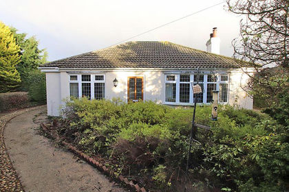
- Price
- £395,000
- Size
- 3 acres
London Road, Raithby-cum-maltby, Raithby cum Maltby, Lincolnshire LN11 England
Added on 04/08/2026House with Land