Land At Lower Road, Arrington, Royston, Cambridgeshire
- Land size
- 38.28 acres
Key Features
- 38.28 Acres (15.49 Hectares) of arable land
- Prior Approval for a new general-purpose agricultural storage building
- Prominent road frontage adjoining the B1042 (Lower Road)
- Strategic location
Description
38.28 Acres (15.49 Hectares) of arable land
Prior Approval for a new general-purpose agricultural storage building
Prominent road frontage adjoining the B1042 (Lower Road)
Strategic location
Detailed Description
LOCATION
The land is well located with prominent road frontage adjoining the B1042 (Lower Road) nearby to the roundabout with the A1198 and A603. The land is approximately 1 mile southwest of the village of Arrington, 5 miles north of the town of Royston and 10 miles west of the City of Cambridge.
What3Words: /// encounter.flagpole.originate
Nearest Postcode: SG8 0HF
THE PROPERTY
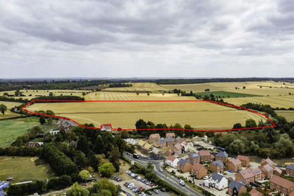
The Land comprises 38.28 acres (15.49 Hectares) of bare arable land in one enclosure. The land is classified as being Grade 3 agricultural land, being capable of growing a wide variety of arable crops and grass. The soil is of the Evesham 3 series, being slowly permeable, calcareous clayey and fine loamy soil. The boundaries comprise hedgerows and road frontage, with all boundaries being well defined.
CROPPING
Harvest Year Crop
2026 Spring Barley
2025 Winter Wheat
2024 Winter Wheat
2023 Winter Wheat
2022 Winter Wheat
There are also areas within in an SFI agreement.
PRIOR APPROVAL FOR AN AGRICULTURAL BUILDING
The land benefits from a Prior Approval for a general-purpose agricultural storage building, the approximate location shown by red box and arrow on the photos in these details. The building is approximately 30m x 17m. Planning reference 26/00227/PRIOR at South Cambridgeshire District Council. The development must be started before the expiration of 5 years from the date of consent- 17th February 2031.
GENERAL REMARKS AND STIPULATIONS
TENURE & METHOD OF SALE
The Land is being sold freehold with vacant possession upon completion, and subject to any rights and easements as described in these particulars of sale.
The Land is offered for sale by way of Private Treaty as a Whole.
TITLE
The Land is registered at the Land Registry and forms part of Title CB428423.
OVERAGE CLAUSE
The Land will be sold subject to an overage provision of 25% for 25 years from the date of completion. Any development outside of agricultural or equestrian will give rise to the overage obligation. The overage payment will be due on the earlier of either implementation or disposal of the Land with the new planning permission.
SERVICES
There are no mains services connected to the Land.
WAYLEAVES, EASEMENTS & RIGHTS OF WAY
The Land is sold subject to and with the benefit of all existing rights of way, whether public or private, light, support, drainage, water and electricity supplies and other rights, easements, quasi-easements and all wayleaves whether referred to or not in these particulars of sale.
SPORTING, MINERALS & TIMBER RIGHTS
The mines and minerals, sporting and timber rights are included in the sale insofar as they vest in the freehold.
HOLDOVER
The Vendor reserves the right to holdover for the purposes of harvesting crops until 30th August 2026.
BASIC PAYMENT SCHEME
The Vendor will retain all de-linked Basic Payment Scheme payments relating to the Land from the 2026 claim year until the scheme comes to an end in 2027.
SUSTAINABLE FARMING INCENTIVE
The Land is subject to a SFI agreement, this will terminate on completion.
NITRATE VULNERABLE ZONE
The Land is situated in a Nitrate Vulnerable Zone for both groundwater and surface water.
DRAINAGE CHARGES
The Land is subject to Environment Agency General Drainage charges, payable at the prevailing rate.
VALUE ADDED TAX
Should the sale of the land, or any right attached to it become a chargeable supply for the purposes of VAT, such tax shall be payable by the Purchaser(s) in addition to the agreed sale price.
BOUNDARIES
The Purchaser shall be deemed to have full knowledge of all boundaries and neither the Vendor, nor the Vendor's Agent, will be responsible for defining the boundaries nor their ownership.
Any red line boundary shown on the photographs are for illustrative purposes only and do not represent the actual boundary and are not to be relied upon.
PLANS & AREAS
These have been prepared as carefully as possible. The plans and photographs are for illustrative purposes only and although they are believed to be correct, their accuracy cannot be guaranteed.
DISPUTES
Should any disputes arise as to the boundaries or any matters relating to the particulars, schedule or interpretation, the matter will be referred to an Arbitrator to be appointed by the Vendor's Agent.
ANTI MONEY LAUNDERING
In accordance with the most recent Anti Money Laundering legislation, the Purchaser will be required to provide proof of identity and an address to the Vendor's Agent once an offer has been submitted and accepted (subject to contract) prior to solicitors being instructed.
VIEWINGS & HEATH AND SAFETY
The Land may be viewed during daylight hours with a copy of these particulars to hand, subject to prior notification to the Vendor's Agent. Viewing is at your own risk and Viewers should be careful and vigilant whilst on the land, particularly when turning on or off of the busy B1042. Neither the Vendor's Agent nor the Vendor are responsible for the safety of those viewing the Land nor do they take any responsibility for any losses or damages incurred during inspection.
LOCAL AUTHORITY
South Cambridgeshire District Council, South Cambridgeshire Hall, Cambourne Business Park, Cambourne, Cambridge, CB23 6EA
VENDOR'S AGENT
Brown & Co, The Fairways, Wyboston Lakes, Great North Road, Wyboston, Bedfordshire, MK44 3AL.
Map Location
Property details
- Tenure
- Ask Agent
- Council Tax Band
- Ask Agent
- Date Posted
- 2026-06-09
Market Value Analysis
Compared with 48 Farmland & Pasture listings in East Anglia (25+ acres).
Utilities & Restrictions
Utilities
- Electricity
- Ask Agent
- Water
- Ask Agent
- Heating
- Ask Agent
- Broadband
- Ask Agent
- Sewerage
- Ask Agent
Rights & Restrictions
- Public Rights of Way
- Ask Agent
- Private Rights of Way
- Ask Agent
- Listed Property
- Ask Agent
- Restrictions
- Ask Agent
Property Features
- Accessibility
- Ask Agent
- Parking
- Ask Agent
- Garden
- Ask Agent
Important notice: Information, maps and tags on this page are supplied by the advertising agent or generated automatically. LandSale has not verified them. Relying on these details is at your own risk, always carry out independent checks before committing to a purchase.
LandSale full disclaimer
Marketing information only - not formal particulars. The details on this website are provided for general guidance and do not constitute an offer or contract. Neither LandSale nor the advertising estate/land agent accepts responsibility for any inaccuracy.
1. Source of information
- Agent-supplied content: Core description, asking price, tenure, measurements, photographs and planning history are uploaded by the appointed agent, who remains solely responsible for their accuracy.
- Automated tags & categorisation: Property type, land-use class, acreage bands and similar labels may be applied by machine-learning models. They are intended as a helpful guide only and may not reflect the property's legal status or permitted use.
- Third-party & enriched data layers: Maps, boundary outlines, planning designations, soil reports, broadband coverage and other environmental or location-based insights are licensed from external suppliers. Such data are supplied “as is", may be incomplete or out of date and are subject to change without notice.
2. Verification required
Prospective purchasers must verify critical matters, including but not limited to planning permission, title boundaries, public rights of way, environmental constraints, acreage, services, access and VAT status, through their own inspections, specialist surveys, legal advisers and the selling agent before relying on the information or entering into any contract.
3. No warranty or liability
LandSale gives no warranty, express or implied, as to the accuracy, completeness or fitness for any particular purpose of the information displayed. LandSale shall not be liable for any loss, damage, cost or expense arising directly or indirectly from any use of or reliance on such information, save where liability may not be excluded by law.
4. Updates & feedback
If you believe any detail on this listing is inaccurate, please let us know. We will investigate and, where appropriate, update the listing or notify the agent.
© LandSale | Version 1.2 - January 2026
Listing agent
BROWN & CO-PROPERTY AND BUSINESS CONSULTANTS LLP, St. Neots
Contact BROWN & CO-PROPERTY AND BUSINESS CONSULTANTS LLP, St. Neots
View agent profileSimilar properties for sale
- Price
- Guide Price£565,000
Willington, Bedford, Bedfordshire, Willington, Bedford MK44 3QS England
Added on 15/07/2026Arable Land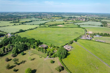
- Price
- Guide Price£375,000
- Size
- 27.07 acres
Added on 02/07/2026Agricultural Land
- Price
- £425,000
- Size
- 25.92 acres
Nags Head Lane, Hargrave, Hargrave, North Northamptonshire NN9 6BN England
Added on 29/01/2026Farmland
- Price
- Guide Price£400,000
- Size
- 0.8 acres
Added on 03/05/2026Development Land
- Price
- Guide Price£420,000
- Size
- 42.7 acres
Arable Land at Winwick, Winwick, Cambridgeshire PE28 5PN England
Added on 22/06/2026Arable Land
- Price
- Guide Price£500,000
- Size
- 5.28 acres
Mancroft Corner, Slip End, Bedfordshire, Slip End, Central Bedfordshire LU1 4DG England
Added on 17/07/2026Vacant Land
- Price
- £725,000
- Size
- 88.87 acres
Land At Wixoe, Stoke By Clare, Sudbury, Suffolk, CO10, Stoke-by-Clare, Suffolk CO10 8TA England
Added on 18/06/2026Farmland
- Price
- Guide Price£325,000
- Size
- 12.63 acres
Added on 29/01/2026Grazing Land
- Price
- Guide Price£315,000
- Size
- 24.37 acres
Added on 22/06/2026Grazing Land
- Price
- Guide Price£495,000
- Size
- 33.6 acres
Land at Epping Road, Ongar, Stanford Rivers, Essex CM5 9SQ England
Added on 25/07/2026Farmland