Wastor, Kingston, PL21
- Land size
- 3 acres
- Bedrooms
- 4
- Bathrooms
- 5
Key Features
- Detached period country home
- Approximately 3 acres
- Beautifully extended & improved
- Open-plan country kitchen/diner
- Four/Five bedrooms
- 5 bathrooms (3 En-Suite)
- Swimming pool & extensive gardens
- Studio, garage & outbuildings
- Formal gardens & meadow
- Walking distance to Wonwell Beach
Description
Wastor Farm is a truly special detached period property, beautifully presented throughout and thoughtfully extended and improved by the current owners to create an exceptional family home extending to approximately 3,090 sq ft. Set in an enviable rural position between the sought after villages of Kingston and Modbury, the property enjoys a wonderful balance of peace and privacy whilst remaining within easy reach of the coast and village amenities.
The house has an abundance of character and charm, combined with beautifully appointed and highly versatile modern accommodation. At the heart of the home is an impressive open plan country style kitchen and dining room, designed as a wonderful social space and featuring bi-fold doors opening onto the rear terrace and gardens. The excellent connection between the kitchen, terrace and grounds makes this an ideal home for both everyday family life and entertaining. Further ground floor accommodation includes an elegant drawing room, a comfortable snug and a useful study, together with a utility room/back kitchen. A ground floor shower room provides useful facilities for family and guests and is ideally positioned for use after enjoying the swimming pool and gardens. Equally, this space could offer the potential to create ground floor accommodation for a dependant relative or similar requirement, subject to any necessary consents. The first floor provides five bedrooms or four bedrooms and a dressing room, offering excellent flexibility. Three of the bedrooms have their own en-suite facilities, whilst the splendid principal bedroom enjoys a beautifully appointed dressing room and en-suite bathroom. The main bedroom takes full advantage of the outlook over the extensive gardens and grounds, whilst the bedrooms to the front enjoy a lovely rural outlook across the surrounding countryside.
Outside, Wastor Farm is particularly impressive. The property is approached through an attractive walled front garden, whilst to the rear the gardens and grounds extend to approximately 3 acres in total. The grounds have been carefully developed to provide a wonderful variety of spaces, including formal lawns, established gardens, wildlife areas and a meadow, creating an idyllic environment for both people and nature. An above ground swimming pool provides a fantastic recreational feature and is perfectly complemented by the adjoining terrace, which provides an excellent space for outdoor dining, entertaining and enjoying the peaceful surroundings. There are also a number of useful outbuildings, including a studio and garage, together with extensive storage and ample parking for numerous vehicles, making the property particularly practical for family life.
The setting is undoubtedly one of Wastor Farm's greatest attributes. Rural and wonderfully peaceful, the property is not isolated, and its position provides the rare opportunity to enjoy the countryside whilst also being within walking distance of the beautiful Wonwell Beach and the village. The surrounding area is renowned for its stunning coastline, rolling countryside and attractive villages, with Modbury providing a good range of everyday amenities and excellent access to the wider South Hams.
SITUATION
Kingston is a sought after village in the South Hams area of South Devon and Wastor Farm occupies a superb location within walking distance to both Wyscombe and Wonwell Beaches. The nearest town of Modbury is about 3 miles away, the larger town of Kingsbridge, offering a greater and wider range of recreation and commercial facilities is about 8 miles distant and the A38 dual carriageway expressway, connecting to the M5 motorway and national road network, being about 7 miles to the north.
Modbury is a picturesque Georgian town situated in an 'Area of Outstanding Natural Beauty'. Some two hundred years ago it was extremely prosperous being the local market town and a centre for the wool trade. Today there is a good range of local shops including a butcher, baker, grocers, chemist, delicatessen and a number of gift and antique shops. Other amenities include a primary school, health centre, dentist, veterinary surgery and mobile library.
Nearby is the magnificent South Hams coastline, offering fine cliff top and coastal walks, beaches and coves, with sailing at Salcombe and Newton Ferrers, 18 hole golf courses being available at Thurlestone and Bigbury, and Dartmoor National Park is within easy reach to the north.
FURTHER INFORMATION
To ensure legal compliance, we require our sellers to complete a Property Information Questionnaire or provide a Material Information Guide along with the title document. If available, please scan the QR code or access the additional online material information Alternatively, you can contact our team for this information.
Verified Material Information
Costs and tenure
Council tax band: G
EPC rating: D
The building
Detached house, standard stone construction
4 bedrooms, 5 bathrooms
Accessibility adaptations: None
Loft: insulated and unboarded, accessed by From the first floor landing
Outside areas: Front garden, Rear garden, and Side garden
No spray foam insulation
Services
Mains electricity
Mains water
Foul drainage: Septic tank
No mains surface water drainage
Oil central heating, installed 1st May 2015
Heating features: Double glazing, wood burner, and open fire
Broadband: ADSL copper wire
Mobile coverage: O2 good, Vodafone ok, Three ok, EE ok
Parking: Garage, Driveway, and Rear
Not in a controlled parking zone
No disabled parking available
Risks and restrictions
Not a listed building
Not in a conservation area
No tree preservation order
No environmental risks recorded
No specialist issues recorded
Onward chain: yes
All information is provided without warranty. Contains HM Land Registry data © Crown copyright and database right 2021. This data is licensed under the Open Government Licence v3.0.
The information contained is intended to help you decide whether the property is suitable for you. You should verify any answers which are important to you with your property lawyer or surveyor or ask for quotes from the appropriate trade experts: builder, plumber, electrician, damp, and timber expert.
VIEWINGS
Strictly by appointment with Luscombe Maye, Modbury
LETTINGS
Luscombe Maye also offers an Award Winning Lettings service. If you are considering Letting your own property, or a buy to let purchase, please contact or to discuss our range of bespoke services.
Map Location
Property details
- Tenure
- Freehold
- Council Tax Band
- G
- Date Posted
- 2026-09-07
Market Value Analysis
Compared with 1,727 Homes with Land listings in South West England (1+ acres).
Energy Performance Certificate
Energy Efficiency Rating
Based on UK Energy Performance Certificate standards (EU Directive 2002/91/EC)
Running costs are one side. Planning activity, flood history and ground risks for this location are in the full report.
Utilities & Restrictions
Utilities
- Electricity
- Mains
- Water
- Mains
- Heating
- Double Glazing, Oil Heating, Central Heating, Open Fire, Wood Burner
- Broadband
- Standard Copper (ADSL)
- Sewerage
- Septic Tank / Private
Rights & Restrictions
- Public Rights of Way
- Ask Agent
- Private Rights of Way
- Ask Agent
- Listed Property
- Ask Agent
- Restrictions
- Ask Agent
Listed status, conservation areas and planning constraints for this location are in the full report.
Property Features
- Accessibility
- Ask Agent
- Parking
- Garage
- Garden
- Patio, Private Garden
Beyond the particulars: planning activity, flood history, heritage and ground risks, checked for this exact spot.
Connectivity
Broadband
Fastest speed available at this postcode
8 Mbps
Under 10 Mbps here
Suitable for
- Basic browsing & email
Fixed wireless access may also be an option here.
Mobile signal
Outdoor predictions; indoor signal depends on building materials.
Ofcom Connected Nations postcode-level predictions. Speeds and signal are modelled, not measured, and vary between addresses and providers.
Signal is the easy part. Planning activity, flood history and protected designations here are in the full report.
Nearest Schools
Primary
- Modbury Primary School1.9 milesOfsted: Good
- Ages
- 4 to 11
- Pupils
- 152
- Type
- Community school
- Holbeton Primary School2 milesOfsted: Good
- Ages
- 2 to 11
- Pupils
- 51
- Type
- Academy converter
- Ermington Primary School2.5 milesOfsted: Good
- Ages
- 4 to 11
- Pupils
- 85
- Type
- Academy converter
- Aveton Gifford CofE Primary School3.2 milesOfsted report card · Jan 2026
- Ages
- 4 to 11
- Pupils
- 97
- Type
- Academy converter
- Faith
- Church of England
- Thurlestone All Saints Church of England Academy4.2 milesNo Ofsted rating
- Ages
- 2 to 11
- Pupils
- 149
- Type
- Academy converter
- Faith
- Church of England
Secondary
- Ivybridge Community College4.6 milesOfsted: Good
- Ages
- 11 to 18
- Pupils
- 2,262
- Type
- Academy converter
- Kingsbridge Academy6.3 milesOfsted: Good
- Ages
- 11 to 18
- Pupils
- 1,199
- Type
- Academy converter
- Plympton Academy7.7 milesOfsted: Requires improvement
- Ages
- 11 to 18
- Pupils
- 984
- Type
- Academy converter
- Coombe Dean School7.9 milesOfsted report card · Mar 2026
- Ages
- 11 to 18
- Pupils
- 1,000
- Type
- Academy converter
- Hele's School8.4 milesNo Ofsted rating
- Ages
- 11 to 18
- Pupils
- 1,378
- Type
- Academy converter
Distances are straight-line from the advertised location. Source: the national school registers (DfE, Welsh Government, Scottish Government) and Ofsted.
Schools are just the start: sold prices nearby, planning activity and any flood history are in the full report.
Amenities
Supermarket
GP surgery
Pharmacy
Hospital
Straight-line distances from the advertised location. Sources: NHS records, Geolytix supermarket locations, OS Open Greenspace and the national trails registers.
The area stacks up? Now check the location itself: planning nearby, protected designations and past flooding.
Getting Around
Nearest station
Nearest bus stop
Typical drive times
Straight-line distances from the advertised location; drive times are typical free-flow times over OpenStreetMap road data, so allow more at peak. Public transport locations from DfT NaPTAN.
Easy to reach matters. So do planning activity, flood history and ground risks: all in the full report.
Flood Risk
From Environment Agency flood map open data, checked around the advertised map pin and allowing for the listed acreage where known. This summary comes from LandSale, the advertising platform, not from the listing agent, and is not part of the agent's particulars. Risk can vary across a single holding, so verify anything critical through your own searches before committing.
Rivers and the sea
Surface water
These bandings are the summary. Where this location sits on the flood maps, plus planning activity, heritage and ground risks, is in the full report.
Important notice: Information, maps and tags on this page are drawn from the advertising agent's marketing materials or generated automatically. LandSale has not verified them. Relying on these details is at your own risk, always carry out independent checks before committing to a purchase.
LandSale full disclaimer
Marketing information only - not formal particulars. The details on this website are provided for general guidance and do not constitute an offer or contract. Neither LandSale nor the advertising estate/land agent accepts responsibility for any inaccuracy.
1. Source of information
- Listing content: Core description, asking price, tenure, measurements, photographs and planning history originate from the marketing materials of the advertising estate or land agent. LandSale does not author this content and cannot guarantee its accuracy.
- Automated tags & categorisation: Property type, land-use class, acreage bands and similar labels may be applied by machine-learning models. They are intended as a helpful guide only and may not reflect the property's legal status or permitted use.
- Third-party & enriched data layers: Maps, boundary outlines, planning designations, soil reports, broadband coverage and other environmental or location-based insights are licensed from external suppliers. Such data are supplied “as is", may be incomplete or out of date and are subject to change without notice.
2. Verification required
Prospective purchasers must verify critical matters, including but not limited to planning permission, title boundaries, public rights of way, environmental constraints, acreage, services, access and VAT status, through their own inspections, specialist surveys, legal advisers and the selling agent before relying on the information or entering into any contract.
3. No warranty or liability
LandSale gives no warranty, express or implied, as to the accuracy, completeness or fitness for any particular purpose of the information displayed. LandSale shall not be liable for any loss, damage, cost or expense arising directly or indirectly from any use of or reliance on such information, save where liability may not be excluded by law.
4. Updates & feedback
If you believe any detail on this listing is inaccurate, please let us know. We will investigate and, where appropriate, update the listing or notify the agent.
© LandSale | Version 1.3 - August 2026
Listing agent
Luscombe Maye, Modbury
3 Church Street, Modbury, PL21 0QW
Similar properties for sale
- Price
- Guide Price£1,150,000
- Size
- 1.2 acres
St Anns Chapel, Kingsbridge, Aveton Gifford, Devon TQ7 England
Added on 15/04/2026Cottage
- Price
- Guide Price£1,100,000
- Size
- 10.03 acres
10.09 Acres - Modbury, Ivybridge, Devon, PL21, Aveton Gifford, Devon PL21 England
Added on 15/08/2026House with Land
- Price
- Guide Price£1,250,000
- Size
- 9 acres
Aveton Gifford, Kingsbridge, Aveton Gifford, Devon TQ7 England
Added on 07/05/2026Country Home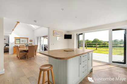
- Price
- Guide Price£1,100,000
- Size
- 3.88 acres
Added on 06/06/2026House with Land
- Price
- Guide Price£1,650,000
- Size
- 4 acres
Added on 30/06/2026Country Home
- Price
- Guide Price£1,100,000
- Size
- 5 acres
Added on 17/08/2026Development Land
- Price
- Guide Price£1,075,000
- Size
- 2.65 acres
Parsonage Road, Newton Ferrers, Plymouth, Devon, Newton and Noss, Devon PL8 England
Added on 10/05/2026Barn Conversion
- Price
- Guide Price£1,375,000
- Size
- 8 acres
Woodleigh, Nr Kingsbridge, TQ7, Woodleigh, Devon TQ7 England
Added on 11/05/2026House with Land
- Price
- £1,750,000
- Size
- 3.84 acres
Added on 28/01/2026Development Land- Price
- Guide Price£1,750,000
- Size
- 3.84 acres
Added on 29/01/2026Development Land