Borewell Farm, Scremerston, Berwick upon Tweed, TD15
- Land size
- 423 acres
Key Features
- Lot 1: 37.7 acres including the farmhouse, farm buildings, holiday park site, telecom mast, solar systems, 12.4 acres permanent grass and 15.0 acres arable.
- Lot 2: 336.4 acres including 286.4 acres arable, 17.7 acres permanent grass and 25.2 acres rough grazing and sea braes.
- Lot 3: 48.9 acres including 48.4 acres arable.
- The property is offered for sale either as a whole or in any combination of the lots.
Description
Borewell Farmhouse
Attractive traditional farmhouse - Three reception rooms, five bedrooms.
Farm Steading
Extensive range of modern and traditional farm buildings some of which provide scope for alternative use.
Pot-A-Doodle-Do
Fully integrated small holiday park site including restaurant and arts centre and with clear scope for expansion.
Land
349.7 acres arable and temporary grass, 30.1 acres permanent grass, 25.2 acres rough grazing and sea braes. Part with medium term development prospects (STP).
GENERAL INFORMATION
SITUATION
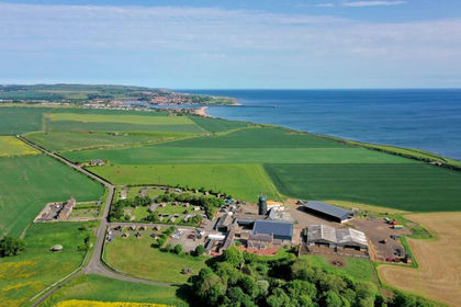
Borewell is located on the fertile east coast plain a short distance to the south of Berwick upon Tweed and to the north east of the satellite village of Scremerston. The farm benefits from magnificent south easterly views down the coast towards Holy Island and The Farnes.
The farm is very accessible being bordered on its west flank by the A1167 which connects to the A1(T) (0.3 miles) which in turn provides direct access to Newcastle and Edinburgh, both of which have international airports. Additionally, there is a mainline railway station at Berwick on the east coast route with direct connections to Edinburgh and Newcastle (45 minutes) and London (3¾ hours).
Berwick upon Tweed (population 14,000) is the northernmost town in England and is situated close to the Scottish border in an area of great natural beauty. Its history is defined by its strategic location at the mouth of the River Tweed which resulted in Berwick changing hands between England and Scotland on numerous occasions before finally being taken by the English in 1482. The Town, and indeed the entire area, has a rich and colourful history with notable local landmarks including the ruins of Berwick’s 12th century castle, the Italian style Elizabethan walls which are still largely intact, Trinity Church constructed by Oliver Cromwell (1648-52), the country’s first purpose built infantry barracks (1717-21), the town’s famous “three bridges” and its Georgian town hall (1754-61). Modern Berwick is an attractive vibrant coastal market town which offers a broad range of services including retail, leisure and financial, a twice weekly open market, a modern theatre and arts centre (“The Maltings”), a recently constructed leisure centre (“The Swan Centre”) and state schools for all ages. Private schooling is available at Longridge Towers, Berwick and St Mary’s, Melrose as well as at a number of schools in and around Edinburgh.
North Northumberland and the Scottish Borders is an area of low population and contrasting landscapes ranging from the upland expanses of the Cheviots and Lammermuirs through the fertile farmland of the Tweed Valley and beyond to the steepling cliffs and golden sands of the east coast. The minor public road which runs through Borewell provides direct access to Cocklawburn beach and Cheswick Sands with Holy Island, the Farne Islands, Budle Bay Nature Reserve and Bamburgh Castle just a short distance down the coast. For the golf enthusiast there are a number of excellent links and inland courses including those at Goswick (5 miles), Bamburgh, Berwick itself and the championship course at the SCHLOSS Roxburghe. There are several local riding schools, numerous lovely walks throughout the area, national hunt racing and curling at Kelso and first class prospects for those interested in field sports.
DIRECTIONS
From the roundabout at the south end of the A1(T) Berwick by-pass take the A1167 to Scremerston. Turn right after 0.2 miles and then left after a further 60 metres at the sign to Cocklawburn Beach and Pot-A-Doodle-Do and follow that road for 0.6 miles to the farm.
What3Words: ///shun.rust.remote
GENERAL DESCRIPTION
Borewell is a first class, highly productive, primarily arable farm with the added attraction of considerable diversified income emanating from its ancillary holiday park business which has been developed by Mrs Christine Whiteford over the last 25 years and which has the potential for significant further expansion. The Whiteford family has farmed at Borewell since 1959 and the farm is now offered for sale due to the impending retirement of the owners.
The farm comprises a single well shaped block divided only by the minor public road leading to the coast and, at the extreme east side, by the railway. It lies between sea level and the 75 metre contour and has an average annual rainfall of approximately 700mm. With the exception of the sea braes, all of the land is classified as grade 3. The arable fields are large and easily worked with minimal waste.
Soils vary but in the main comprise fine sandy-clay loams of medium constituency (Salop Series) with a significant clay fraction and limited stone content and are well suited to the consistent production of high yielding grass and cash crops, particularly winter wheat. Field drainage is generally good. There is trough water to a number of fields and the majority of fields can be reached either directly off the minor public road or via two good internal hard tracks. Soil indices have been well maintained and the land is clean with no significant weed ingress. With the exception of approximately 8 acres of permanent grass, the land to the east of the railway comprises sea braes and rough grazing.
Borewell has been farmed alongside other adjoining land, much of which comprises permanent grass and dunes. The two farms together carry approximately 150 spring calving suckler cows based on 110 Belgian Blue cross and 40 pedigree Angus. Commercial progeny is usually sold at 18-20 months as strong stores whilst some of the pedigree bulls are sold to breed and the remainder (other than replacement stock) are fattened on a bull beef type system. Some of the cows are outwintered on the coastal strip and these, together with the housed cattle, are fed on a silage based system with approximately 25 acres sown down to high protein clover swards and a further acreage devoted to whole crop.
The arable acreage has been farmed on a non-inversive minimum tillage system based principally on first and second wheats, winter oilseed , winter beans and spring barley. All grain is dried with a mobile system.
There is an extensive steading complex which provides more than adequate cover for the farm and which includes several traditional buildings which would lend themselves to residential conversion - subject to all requisite consents.
Borewell Farmhouse is a lovely traditional south facing family farmhouse which is situated directly to the south east of the farm buildings with its own private access drive and walled garden.
Pot-A-Doodle-Do is a fully integrated, well established small holiday park which includes licenced restaurant facilities, an arts and educational centre, glamping accommodation, a children’s play area and climbing wall together with ancillary services. It generates significant additional income and has the scope for considerable expansion both of the existing uses and with the integration of a variety of compatible operations making use of the existing infrastructure and the magnificent coastal location - subject to the obtaining of all the necessary consents.
Further diversified income emanates from a telecom mast and two small solar schemes.
SPORTING
The sporting rights are in-hand but are rarely exercised. There is a small duck pond in enclosure 18 within lot 2.
PLANNING
It is thought that some of the traditional farm buildings would be suitable for residential conversion - subject to all normal consents.
Class Q Permitted Development Rights (for which prior approval is needed) currently provides for the conversion without planning consent of agricultural buildings into residential use - subject to certain conditions and caveats.
Additionally, some of the modern buildings could be converted into a variety of uses ancillary to the holiday park including restaurant, wedding venue and equine - subject to all normal consents.
The land at the north end of the farm (Lot 3) adjacent to Elmbank Coastal Park appears to have significant latent development potential.
ENVIRONMENTAL STEWARDSHIP AND SFI
The farm is covered by an Environmental Stewardship Agreement (Ref: AG00564811) which runs until 30 September 2028. The Agreement covers both Borewell and other land farmed by the Vendors. The Agreement in respect of Borewell currently pays an annual grant of £11,500 and embraces a range of arable, grassland and boundary management options together with maintenance of the traditional buildings within the steading.
The Purchasers will be obligated to take on the Scheme and to indemnify the Vendors against any future breaches.
Additionally, there are various SFI Agreements across the farm, but these are not transferable under current SFI rules.
RENEWABLE ENERGY
There are two separate roof mounted solar systems, the larger of which (50kW) serves Pot-A-Doodle-Do with a smaller 10kW system supplying electricity to the the farmhouse and steading. In addition to significantly offsetting the annual cost of electricity, the FIT contracts have produced an annual average payment of £9,880 in recent years. The systems were installed in 2013 and the twenty year FIT contracts will therefore expire in April 2033. One of the contracts is held with Scottish Power and the other with British Gas.
TELECOM MAST
There is a telecom mast Lease in favour of Vodafone Ltd. The mast is attached to the higher of the two wet grain silos. The adjoining small traditional lean-to houses the control equipment and forms part of the Lease. The Tenant is holding over but has confirmed that it wishes to renew the Lease. The current annual rent (including site share) is £9,432.
RIGHTS, EASEMENTS AND OUTGOINGS
The property is sold subject to and with the benefit of all rights of way, whether public or private, and any existing or proposed wayleaves, easements, servitude rights, restrictions and burdens of whatever kind, whether referred to in these particulars or not. The Purchasers will be held to have satisfied themselves on all such matters.
LOTTING
The property is offered for sale either as a whole or in any combination of the following lots:
Lot 1: 37.7 acres including the farmhouse, farm buildings, holiday park site, telecom mast, solar systems, 12.4 acres permanent grass and 15.0 acres arable.
Lot 2: 336.4 acres including 286.4 acres arable, 17.7 acres permanent grass and 25.2 acres rough grazing and sea braes.
Lot 3: 48.9 acres including 48.4 acres arable.
In the event that the property is sold in lots, each individual lot will be granted such easements as necessary to enable it to be properly serviced and enjoyed.
METHOD OF SALE
The property is offered for sale with vacant possession by private treaty with entry by arrangement between the parties.
A closing date for offers may be fixed and interested parties are advised to register their interest with the Selling Agents.
The Vendors shall not be bound to accept the highest or indeed any offer.
OFFERS
Offers in writing should be submitted to the Selling Agents.
Map Location
Property details
- Tenure
- Freehold
- Council Tax Band
- Ask Agent
- Date Posted
- 2026-09-07
Market Value Analysis
Compared with 9 Farms & Smallholdings listings in North East England (250+ acres).
Utilities & Restrictions
Utilities
- Electricity
- Ask Agent
- Water
- Ask Agent
- Heating
- Ask Agent
- Broadband
- Ask Agent
- Sewerage
- Ask Agent
Rights & Restrictions
- Public Rights of Way
- Ask Agent
- Private Rights of Way
- Ask Agent
- Listed Property
- Ask Agent
- Restrictions
- Ask Agent
Listed status, conservation areas and planning constraints for this location are in the full report.
Property Features
- Accessibility
- Ask Agent
- Parking
- Ask Agent
- Garden
- Ask Agent
Beyond the particulars: planning activity, flood history, heritage and ground risks, checked for this exact spot.
Connectivity
Broadband
Fastest speed available at this postcode
8.5 Gbps
Gigabit full fibre · available to 87% of premises
Suitable for
- 4K streaming on every screen
- Full-time home working
- Online gaming & big downloads
Mobile signal
Outdoor predictions; indoor signal depends on building materials.
Ofcom Connected Nations postcode-level predictions. Speeds and signal are modelled, not measured, and vary between addresses and providers.
Signal is the easy part. Planning activity, flood history and protected designations here are in the full report.
Nearest Schools
Primary
- Scremerston First School942 metresOfsted: Good *
- Ages
- 4 to 11
- Pupils
- 38
- Type
- Community school
- Spittal Community Primary School1.4 milesNo Ofsted rating
- Ages
- 4 to 11
- Pupils
- 128
- Type
- Community school
- Prior Park Primary School1.6 milesOfsted: Good
- Ages
- 3 to 11
- Pupils
- 110
- Type
- Community school
- Tweedmouth West Primary School2.3 milesOfsted: Good
- Ages
- 4 to 11
- Pupils
- 145
- Type
- Community school
- St Cuthberts Catholic Primary School, Berwick2.3 milesNo Ofsted rating
- Ages
- 3 to 11
- Pupils
- 98
- Type
- Academy converter
- Faith
- Roman Catholic
Secondary
- Berwick Academy1.5 milesOfsted: Requires improvement
- Ages
- 13 to 18
- Pupils
- 601
- Type
- Academy converter
- The Duchess's Community High School26 milesOfsted: Requires improvement
- Ages
- 11 to 18
- Pupils
- 1,276
- Type
- Academy converter
- Dr Thomlinson Church of England Middle School30 milesNo Ofsted rating
- Ages
- 9 to 13
- Pupils
- 184
- Type
- Academy converter
- Faith
- Church of England
- James Calvert Spence College32 milesOfsted: Good
- Ages
- 11 to 19
- Pupils
- 567
- Type
- Community school
- The King Edward VI School41 milesOfsted: Good *
- Ages
- 13 to 18
- Pupils
- 1,426
- Type
- Academy converter
* Latest graded judgement covers quality of education only; no overall grade was issued under the 2024-25 inspection framework.
Distances are straight-line from the advertised location. Source: the national school registers (DfE, Welsh Government, Scottish Government) and Ofsted.
Schools are just the start: sold prices nearby, planning activity and any flood history are in the full report.
Amenities
Supermarket
GP surgery
Pharmacy
Hospital
Green space
Straight-line distances from the advertised location. Sources: NHS records, Geolytix supermarket locations, OS Open Greenspace and the national trails registers.
The area stacks up? Now check the location itself: planning nearby, protected designations and past flooding.
Getting Around
Nearest station
Nearest bus stop
Typical drive times
Straight-line distances from the advertised location; drive times are typical free-flow times over OpenStreetMap road data, so allow more at peak. Public transport locations from DfT NaPTAN.
Easy to reach matters. So do planning activity, flood history and ground risks: all in the full report.
Flood Risk
From Environment Agency flood map open data, checked around the advertised map pin and allowing for the listed acreage where known. This summary comes from LandSale, the advertising platform, not from the listing agent, and is not part of the agent's particulars. Risk can vary across a single holding, so verify anything critical through your own searches before committing.
Rivers and the sea
Mapped within the area searched, not at the advertised map pin itself.
Surface water
Mapped within the area searched, not at the advertised map pin itself.
The detail behind these bandings
The full report pinpoints where this location sits on the flood maps, and runs the deeper checks that usually only surface after an offer.
- Exact flood zones & annual chances (included in the full report)
- Any recorded past flooding (included in the full report)
- Planning activity nearby (included in the full report)
- Heritage & conservation (included in the full report)
- Protected nature designations (included in the full report)
- Ground risks (included in the full report)
- Sold prices nearby (included in the full report)
£14.99 · one-off purchase
By LandSale, the platform. Not provided by the listing agent. Ready in about a minute.
Important notice: Information, maps and tags on this page are drawn from the advertising agent's marketing materials or generated automatically. LandSale has not verified them. Relying on these details is at your own risk, always carry out independent checks before committing to a purchase.
LandSale full disclaimer
Marketing information only - not formal particulars. The details on this website are provided for general guidance and do not constitute an offer or contract. Neither LandSale nor the advertising estate/land agent accepts responsibility for any inaccuracy.
1. Source of information
- Listing content: Core description, asking price, tenure, measurements, photographs and planning history originate from the marketing materials of the advertising estate or land agent. LandSale does not author this content and cannot guarantee its accuracy.
- Automated tags & categorisation: Property type, land-use class, acreage bands and similar labels may be applied by machine-learning models. They are intended as a helpful guide only and may not reflect the property's legal status or permitted use.
- Third-party & enriched data layers: Maps, boundary outlines, planning designations, soil reports, broadband coverage and other environmental or location-based insights are licensed from external suppliers. Such data are supplied “as is", may be incomplete or out of date and are subject to change without notice.
2. Verification required
Prospective purchasers must verify critical matters, including but not limited to planning permission, title boundaries, public rights of way, environmental constraints, acreage, services, access and VAT status, through their own inspections, specialist surveys, legal advisers and the selling agent before relying on the information or entering into any contract.
3. No warranty or liability
LandSale gives no warranty, express or implied, as to the accuracy, completeness or fitness for any particular purpose of the information displayed. LandSale shall not be liable for any loss, damage, cost or expense arising directly or indirectly from any use of or reliance on such information, save where liability may not be excluded by law.
4. Updates & feedback
If you believe any detail on this listing is inaccurate, please let us know. We will investigate and, where appropriate, update the listing or notify the agent.
© LandSale | Version 1.3 - August 2026
Listing agent
EDWIN THOMPSON PROPERTY SERVICES LIMITED, Berwick
Contact EDWIN THOMPSON PROPERTY SERVICES LIMITED, Berwick
View agent profileSimilar properties for sale
- Price
- Offers in Region of£5,200,000
- Size
- 423 acres
Borewell Farm, Scremerston, Berwick upon Tweed, Ancroft, Northumberland TD15 England
Added on 07/09/2026Farm
- Price
- Offers Over£3,500,000
- Size
- 2.5 acres
The Glebe House, 4 Law Road, North Berwick, East Lothian, Lothian East, East Lothian EH39 Scotland
Added on 06/04/2026House with Land
- Price
- Offers Over£4,000,000
- Size
- 331.6 acres
South Farm, Ryal, Northumberland, Matfen, Northumberland NE20 England
Added on 11/07/2026Farm- Price
- Offers Over£4,000,000
- Size
- 331.6 acres
South Farm, Ryal, Northumberland, Matfen, Northumberland NE20 England
Added on 14/07/2026Farm
- Price
- Offers in Excess of£3,150,000
- Size
- 24 acres
Milbourne Hall, Newcastle Upon Tyne, Ponteland, Northumberland NE20 England
Added on 29/01/2026House with Land
- Price
- Guide Price£4,950,000
- Size
- 2.8 acres
Springfield House, Spoutwell Lane, Corbridge, Northumberland, Corbridge, Northumberland NE45 England
Added on 06/02/2026Estate
- Price
- Guide Price£4,950,000
- Size
- 2.8 acres
Springfield House, Spoutwell Lane, Corbridge, Northumberland, Corbridge, Northumberland NE45 England
Added on 14/03/2026Country Home
- Price
- Offers in Excess of£3,700,000
- Size
- 15 acres
Ormiston Castle, West Lothian, EH27, Livingston, West Lothian EH27 Scotland
Added on 13/05/2026House with Land
- Price
- Guide Price£4,600,000
- Size
- 395.31 acres
Low Harperley Farm, Wolsingham, Wolsingham, County Durham DL15 England
Added on 24/04/2026Farm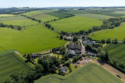
- Price
- Offers Over£5,900,000
- Size
- 486.17 acres
Balnacake and Netherton Farms, Brechin, Angus, DD9, Angus and Perthshire Glens, Angus DD9 Scotland
Added on 07/07/2026Farm