Hillside Road, Linton, DE12
- Land size
- 2.2 acres
- Bedrooms
- 6
- Bathrooms
- 5
Key Features
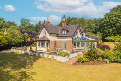
- Exceptional Grade II Listed Manor House dating to the 17th Century
- Set within 2.2 acres of private mature gardens and grounds in the National Forest
- Stunning open countryside views from the grounds and principal rooms
- Beautiful farmhouse kitchen with AGA, exposed beams and garden access
- Elegant reception rooms with original Minton tiles, period fireplaces and coving
- Dedicated cinema room
- Top-floor private gym and luxury steam room
- Year-round summer house with log burner, overlooking the tennis court and countryside
- Private grass tennis court set within the grounds
- Triple garage block with additional store and extensive parking
Description
Hidden within over two acres of private gardens and woodland, The Manor House is a magnificent Grade II Listed country residence dating back to the 17th Century. Offering over 6,500 sq ft of beautifully balanced accommodation, it combines heritage, privacy and exceptional family living in one remarkable home.
The Details:
Some homes stop you in your tracks the moment you arrive. The Manor House is one of those rare places — a Grade II Listed residence believed to date to the 17th Century, set within 2.2 acres of private grounds in the heart of the National Forest, with countryside views stretching out in every direction.
Inside, the accommodation extends to over 5,200 sq ft across three floors. The beautiful farmhouse kitchen sits at the heart of the home, complete with an impressive AGA, exposed beams and French doors to the garden — the kind of room where everyone naturally gravitates. Generous reception rooms flow throughout the ground floor, each rich with period character: original Minton tile flooring in the entrance hall, elegant coving, period fireplaces and deep multi-pane windows that frame the grounds beautifully. The dining room is a spectacular entertaining space, and a separate sitting room offers quieter moments beside the fire. For modern family life, a dedicated cinema room with epic surround sound provides the ultimate retreat — the best of both worlds, without compromise.
The first floor delivers spacious bedroom accommodation with far-reaching views, while the top floor has been transformed into a superb private gym complete with professional equipment and a remarkable steam room — a wellness space that rivals anything a luxury spa could offer.
Step outside and the grounds truly set this property apart. Extending to approximately 2.2 acres of private, mature gardens, the setting is peaceful, secluded and utterly beautiful. A lawned tennis court sits within the grounds, and beside it, a charming converted summer house — fully insulated and useable year-round — with exposed brick walls, timber flooring, log burner and countryside views that make it feel every bit like a private pub. Whether it's hosting friends, summer evenings or quiet mornings with a coffee, this space is something genuinely special. The substantial triple garage block with additional store provides excellent flexibility for vehicles, hobbies or further storage, all set within a private courtyard to the rear.
Linton is one of those quietly special villages that offers exactly the lifestyle so many buyers are searching for — space, scenery and a slower pace, without feeling disconnected from the world. Set within the heart of the National Forest, the village is surrounded by beautiful countryside, woodland walks and open green spaces. Nearby Foremark Reservoir, Calke Abbey and Staunton Harold provide wonderful days out, while Ashby-de-la-Zouch — just a short drive away — offers independent cafés, restaurants and a strong community feel. For commuters, the A42/M42 and A38 provide excellent access towards Birmingham, Derby, Nottingham and Leicester. Families are well served by local schooling and respected independents including Repton and Loughborough Schools within reach.
Disclaimer
This property advertisement is for general guidance only. Berkley Letting and Estate Agents do not guarantee that all details—including measurements, floor plans, descriptions, photos, appliances, fixtures, or services—are accurate or in working order. The information does not form part of any contract or offer. Prospective buyers or tenants should verify all details themselves by inspection or other independent means. For further information, including Energy Performance Certificates or other documents required by UK law, please contact the agent directly.
Map Location
Property details
- Tenure
- Freehold
- Council Tax Band
- G
- Date Posted
- 2026-09-02
Market Value Analysis
Compared with 708 Homes with Land listings in East Midlands (1+ acres).
Utilities & Restrictions
Utilities
- Electricity
- Ask Agent
- Water
- Ask Agent
- Heating
- Ask Agent
- Broadband
- Ask Agent
- Sewerage
- Ask Agent
Rights & Restrictions
- Public Rights of Way
- Ask Agent
- Private Rights of Way
- Ask Agent
- Listed Property
- Ask Agent
- Restrictions
- Ask Agent
Listed status, conservation areas and planning constraints for this location are in the full report.
Property Features
- Accessibility
- Ask Agent
- Parking
- Parking Available
- Garden
- Private Garden
Beyond the particulars: planning activity, flood history, heritage and ground risks, checked for this exact spot.
Connectivity
Broadband
Fastest speed available at this postcode
10 Gbps
Ultrafast
Suitable for
- 4K streaming on every screen
- Full-time home working
- Online gaming & big downloads
Mobile signal
Predicted 4G and 5G signal; indoor signal depends on building materials.
Ofcom Connected Nations postcode-level predictions. Speeds and signal are modelled, not measured, and vary between addresses and providers.
Signal is the easy part. Planning activity, flood history and protected designations here are in the full report.
Nearest Schools
Primary
- Linton Primary School671 metresOfsted: Good *
- Ages
- 3 to 11
- Pupils
- 278
- Type
- Foundation school
- St George's CofE Primary School1.7 milesNo Ofsted rating
- Ages
- 4 to 11
- Pupils
- 198
- Type
- Academy converter
- Faith
- Church of England
- Overseal Primary School1.7 milesOfsted report card · Mar 2026
- Ages
- 4 to 11
- Pupils
- 204
- Type
- Community school
- Church Gresley Infant and Nursery School1.7 milesNo Ofsted rating
- Ages
- 3 to 7
- Pupils
- 314
- Type
- Academy converter
- Pennine Way Junior Academy1.7 milesOfsted: Good
- Ages
- 7 to 11
- Pupils
- 358
- Type
- Academy converter
Secondary
- The Pingle Academy2.4 milesOfsted report card · Feb 2026
- Ages
- 11 to 18
- Pupils
- 1,363
- Type
- Academy converter
- Mercia Academy2.7 milesOfsted: Requires improvement *
- Ages
- 11 to 16
- Pupils
- 592
- Type
- Academy sponsor led
- Blessed Robert Sutton Catholic Voluntary Academy2.7 milesOfsted: Outstanding
- Ages
- 11 to 16
- Pupils
- 632
- Type
- Academy converter
- Faith
- Roman Catholic
- Paulet High School3 milesOfsted: Good
- Ages
- 11 to 18
- Pupils
- 915
- Type
- Academy converter
- Granville Academy3.1 milesOfsted: Good *
- Ages
- 11 to 16
- Pupils
- 914
- Type
- Academy converter
* Latest graded judgement covers quality of education only; no overall grade was issued under the 2024-25 inspection framework.
Distances are straight-line from the advertised location. Source: the national school registers (DfE, Welsh Government, Scottish Government) and Ofsted.
Schools are just the start: sold prices nearby, planning activity and any flood history are in the full report.
Amenities
Supermarket
GP surgery
Pharmacy
Hospital
Green space
Straight-line distances from the advertised location. Sources: NHS records, Geolytix supermarket locations, OS Open Greenspace and the national trails registers.
The area stacks up? Now check the location itself: planning nearby, protected designations and past flooding.
Getting Around
Nearest station
Nearest bus stop
Typical drive times
Straight-line distances from the advertised location; drive times are typical free-flow times over OpenStreetMap road data, so allow more at peak. Public transport locations from DfT NaPTAN.
Easy to reach matters. So do planning activity, flood history and ground risks: all in the full report.
Flood Risk
Environment Agency open data, checked around the advertised map pin for the listed acreage. Long-term risk counts flood defences; the planning map's flood zones do not. Provided by LandSale, not the listing agent, and not part of the agent's particulars. Risk varies across a holding, so verify before committing.
Rivers and the sea
Planning map: Flood Zone 1.
Surface water
Not at the pin: mapped about 40 metres away.
These bandings are the summary. Where this location sits on the flood maps, plus planning activity, heritage and ground risks, is in the full report.
Important notice: Information, maps and tags on this page are drawn from the advertising agent's marketing materials or generated automatically. LandSale has not verified them. Relying on these details is at your own risk, always carry out independent checks before committing to a purchase.
LandSale full disclaimer
Marketing information only - not formal particulars. The details on this website are provided for general guidance and do not constitute an offer or contract. Neither LandSale nor the advertising estate/land agent accepts responsibility for any inaccuracy.
1. Source of information
- Listing content: Core description, asking price, tenure, measurements, photographs and planning history originate from the marketing materials of the advertising estate or land agent. LandSale does not author this content and cannot guarantee its accuracy.
- Automated tags & categorisation: Property type, land-use class, acreage bands and similar labels may be applied by machine-learning models. They are intended as a helpful guide only and may not reflect the property's legal status or permitted use.
- Third-party & enriched data layers: Maps, boundary outlines, planning designations, soil reports, broadband coverage and other environmental or location-based insights are licensed from external suppliers. Such data are supplied “as is", may be incomplete or out of date and are subject to change without notice.
2. Verification required
Prospective purchasers must verify critical matters, including but not limited to planning permission, title boundaries, public rights of way, environmental constraints, acreage, services, access and VAT status, through their own inspections, specialist surveys, legal advisers and the selling agent before relying on the information or entering into any contract.
3. No warranty or liability
LandSale gives no warranty, express or implied, as to the accuracy, completeness or fitness for any particular purpose of the information displayed. LandSale shall not be liable for any loss, damage, cost or expense arising directly or indirectly from any use of or reliance on such information, save where liability may not be excluded by law.
4. Updates & feedback
If you believe any detail on this listing is inaccurate, please let us know. We will investigate and, where appropriate, update the listing or notify the agent.
© LandSale | Version 1.3 - August 2026
Listing agent
Berkley Estate & Letting Agents, Kibworth
44 High Street, Kibworth, LE8 0HQ
Contact Berkley Estate & Letting Agents, Kibworth
44 High Street, Kibworth, LE8 0HQ
View agent profileSimilar properties for sale
- Price
- £1,395,000
- Size
- 1.3 acres
Cottage Farm, Grangewood, Netherseal, Netherseal, Derbyshire DE12 England
Added on 16/07/2026House with Land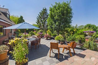
- Price
- £1,350,000
- Size
- 9.74 acres
Added on 23/07/2026House with Land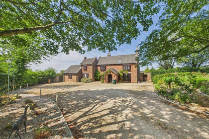
- Price
- £1,325,000
- Size
- 7.2 acres
Greysich Lane, Bretby, Burton On Trent, Bretby, Derbyshire DE15 England
Added on 24/07/2026House with Land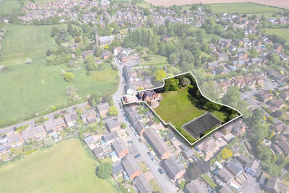
- Price
- Offers in Excess of£1,100,000
- Size
- 1.5 acres
Church Street, Appleby Magna, Swadlincote, Appleby Magna, Leicestershire DE12 England
Added on 29/01/2026House with Land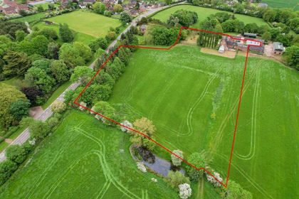
- Price
- Guide Price£1,200,000
- Size
- 4.5 acres
Measham Road, Snarestone, DE12, Measham, Leicestershire DE12 England
Added on 29/01/2026House with Land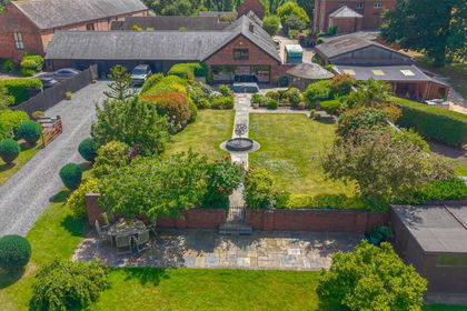
- Price
- Offers in Excess of£1,575,000
- Size
- 2 acres
Brookfields, Brickhouse Lane, Elford, B79, Elford, Staffordshire B79 England
Added on 03/05/2026Barn Conversion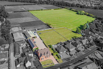
- Price
- £1,125,000
- Size
- 10 acres
Craythorne Road, Stretton, Burton-On-Trent, Stretton, Staffordshire DE13 England
Added on 28/01/2026House with Land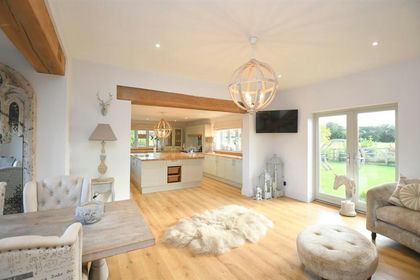
- Price
- Guide Price£1,125,000
- Size
- 4.25 acres
The Pump House, New Gate Court, Main Road, Anslow, DE13, Anslow, Staffordshire DE13 England
Added on 04/08/2026Barn Conversion
- Price
- Guide Price£1,250,000
- Size
- 9.1 acres
Greenways, Church Road, Egginton, DE65, Egginton, Derbyshire DE65 England
Added on 30/07/2026House with Land
- Price
- Guide Price£1,625,000
- Size
- 2 acres
Elford Road, Elford, Staffordshire, B79, Elford, Staffordshire B79 England
Added on 08/07/2026Country Home