The site sits adjacent to Heald Green Station, off finney Lane, Stocport, SK8
- Land size
- 1 acres
Description
Exceptional Residential-Led Development Opportunity Adjacent to Heald Green Station – Prime Freehold Site with Pre-Application for 31 Units, Retail & Community Space
Property Description
A rare and substantial freehold development site extends to approximately 0.64–1.0 acres (precise area to be confirmed by title and plan). It is immediately adjacent to Heald Green Station, off Finny Lane, in the highly sought-after suburb of Heald Green, Stockport. The property is currently utilized as surface car parking and occupies a prominent position with direct access to the station. This offers unrivalled connectivity to Manchester Piccadilly, Manchester Airport, and the wider North West region. The land is generally level, bounded by the railway line to the east and established mixed-use development to the west. There are mature trees and a public footpath along the western boundary. The immediate area is characterised by a blend of residential, retail, and community uses. This underpins robust demand for new homes and amenities. The site’s strategic location, scale, and context make it ideally suited for a landmark residential-led mixed-use development, subject to planning. Register to bid - Residential-Led Development Opportunity Heald Green Station
Development Potential
The site has been the subject of a comprehensive pre-application feasibility study (Suburban Studios, March 2010). This outlines a high-quality residential-led mixed-use scheme. The scheme comprises 31 residential units of mixed tenure, a retail shop, a community space, surface car parking, cycle storage, and landscaped amenity areas. The proposed design features two principal blocks: Block A, a four-storey landmark building at the site’s focal point, and Block B, a linear block running parallel to the railway. The scheme has been developed with careful attention to privacy, daylight, acoustic mitigation, and sustainability. It targets Code for Sustainable Homes Level 4 and incorporates green/brown roofs and renewable energy strategies. This proposal responds to the site’s unique context, maximising development potential while respecting neighbouring uses and enhancing local amenity. The site’s scale and configuration make it ideally suited for a significant residential development, subject to securing full planning consent. Comparable sites in the area have demonstrated strong market appetite for well-located, rail-adjacent development opportunities.
Planning and Policy Context
Planning Status There is limited recent planning history for the site itself. The most relevant is a 2002 permission for the erection of garages and boundary treatments (DC008663). This came with a condition restricting use to car parking. The current pre-application submission (March 2010) has been positively received in principle. However, it is subject to detailed design and technical considerations. The pre-application feasibility document (available in the legal pack) confirms that the proposal has been tested against local design guidelines and planning criteria. Moreover, early engagement with the council’s planning officers has informed the scheme. Key considerations include massing and layout, provision of affordable housing, sustainable drainage, renewable energy features, and enhanced pedestrian and cycle connectivity.
Local Plan and Policy Framework
The site is not within a conservation area, Green Belt, or flood risk zone. It is classified as previously developed (brownfield) land. The Stockport Local Plan and Core Strategy support residential-led mixed-use development in accessible locations. This particularly applies to those adjacent to public transport nodes such as Heald Green Station. Policy CS4 (Distribution of Housing) and Policy H-1 (Design of Residential Development) require that new housing is located in accessible locations, achieves high standards of design, and contributes to meeting local housing needs. Furthermore, Policy CS9 (Transport and Development) and T-1 (Transport and Development) support development in locations with good public transport. However, this is subject to appropriate parking, access, and mitigation of any adverse impacts. The emerging Local Plan identifies Heald Green as a focus for modest housing growth, with allocations for new homes primarily to the west of the railway line. The current policy context therefore supports residential development on well-located sites such as this. However, this support is provided that design, amenity, and infrastructure requirements are met.
Site Designations and Constraints
Conservation Area: The site is not within a designated conservation area and is not subject to Article 4 Directions.
Flood Risk: The site is classified as very low risk for river, surface water, and groundwater flooding.
Environmental Designations: No SSSI, Local Nature Reserve, or Site of Biological Importance applies. There are no Tree Preservation Orders directly affecting the site, though mature boundary trees should be retained where possible.
Permitted Development Rights: Standard permitted development rights apply, but the proposed scale of development will require full planning permission.
Planning Reference
A search of the Stockport planning portal does not return any current or determined planning application under reference. There is no evidence of any recent refusal or appeal affecting the site.
Location
Heald Green is a vibrant and well-connected suburb of Stockport, benefitting from immediate access to Heald Green Station (Manchester Piccadilly 15 minutes, Manchester Airport 5 minutes), extensive local amenities along Finny Lane, and proximity to major road networks including the M56 and M60. The area is characterised by strong residential demand, excellent schools, and a thriving local centre. The site’s adjacency to the station and established community infrastructure makes it uniquely positioned for a high-quality development catering to commuters, families, and local residents alike.
Tenure
Freehold
Guide Price Recommendation
Guide Price: £400,000 Rationale and Comparable Evidence The recommended guide price of £850,000+ is based on a detailed analysis of recent development land sales in Heald Green, Stockport, the SK8 postcode, and the wider Greater Manchester/Cheshire region. The analysis focused on sites of similar scale, density, and proximity to railway stations. The following comparables underpin the guide price:
Mauldeth Road, Lady barn, Manchester M14: 24 units on 0.84 acres (lapsed planning), sold at £900,000 (2026), equating to £1,071,429 per acre and £37,500 per unit.
Droylsden Town Centre, Manchester: 40 units on 2.3 acres (residential consent), sold at £1,800,000 (2025), £782,609 per acre and £45,000 per unit.
Oldham (Hartford Mill site): 200+ units on 8.7 acres (full planning), sold at £7,500,000 (2025), £862,069 per acre and £37,500 per unit.
Standish, Chorley Road: 9 dwellings on 1.16 acres (full planning), sold at £650,000 (2025), £560,345 per acre and £72,222 per unit.
Redbank, Manchester City Centre: 30 units (estimated) on 0.4 acres (mixed-use), sold at £1,200,000 (2025), £3,000,000 per acre and £40,000 per unit.
Values for the site
For the subject site, with a proposed scheme of 31 units plus commercial/community space on approximately 0.8–1.0 acres, the guide price of £850,000+ equates to approximately £27,400 per unit and £850,000–£1,062,500 per acre. This reflects the site’s strong development potential and excellent transport connectivity. However, the absence of full planning permission means the value is lower. Full planning permission would command a higher value. The guide price is set to encourage competitive bidding. It reflects the significant uplift potential subject to planning. Additionally, properties at auction frequently achieve 15–25% above guide price, depending on market conditions and buyer demand.
Legal Pack
The legal pack, including title documents, pre-application feasibility study, planning correspondence, and special conditions of sale, is available to download from the Palace Auctions London website. Prospective bidders are strongly advised to review the legal pack in full prior to bidding. They should consult their legal advisers.
Viewing Arrangements
The site may be inspected externally at any reasonable time. For accompanied viewings or further information, please contact Palace Auctions London on . Alternatively, email .
Special Conditions
Buyer’s Premium is charged by the auctioneers of 2% of the hammer price. A Buyer’s Fee of £1,200 (inclusive of VAT) is payable on the fall of the hammer. Additional charges and fees may apply; please refer to the Special Conditions of Sale and the legal pack for full details. All bidders must register in advance and complete anti-money laundering checks prior to bidding. The property is sold subject to the RICS Common Auction Conditions (Edition 4) and the Special Conditions of Sale. Prospective buyers are strongly advised to verify all particulars, planning status, and measurements independently. The guide price is an indication of the seller’s minimum expectation at auction and may be subject to change prior to the sale. The reserve price will not exceed 10% above the guide price in accordance with Advertising Standards Authority regulations. Please consult the addendum and legal pack for any updates prior to bidding.
Auction Venue:
Discover a rare opportunity to acquire Land Adjacent to Heald Green Station, Finny Lane, Heald Green, Stockport SK8 3DY at our highly anticipated live and online property auction, taking place on 23rd September 2026 at 1 pm in the iconic St James Room at Claridge’s, Mayfair, London. Renowned for its Art Deco elegance and world-class service, Claridge’s offers an unrivalled setting for discerning buyers. Whether you join us in person or bid online from anywhere in the world, you’ll benefit from state-of-the-art auction technology and a seamless experience. Register now to secure your place at this exclusive event and take the first step towards owning a prime property in one of Stockport's most sought-after locations."
Map Location
Property details
- Tenure
- Freehold
- Council Tax Band
- Ask Agent
- Date Posted
- 2026-09-02
Market Value Analysis
Compared with 132 Development Land listings in North West England (1+ acres).
Utilities & Restrictions
Utilities
- Electricity
- Ask Agent
- Water
- Ask Agent
- Heating
- Ask Agent
- Broadband
- Ask Agent
- Sewerage
- Ask Agent
Rights & Restrictions
- Public Rights of Way
- Ask Agent
- Private Rights of Way
- Ask Agent
- Listed Property
- Ask Agent
- Restrictions
- Ask Agent
Listed status, conservation areas and planning constraints for this location are in the full report.
Property Features
- Accessibility
- Ask Agent
- Parking
- Ask Agent
- Garden
- Ask Agent
Beyond the particulars: planning activity, flood history, heritage and ground risks, checked for this exact spot.
Connectivity
Broadband
Fastest speed available at this postcode
10 Gbps
Gigabit full fibre
Suitable for
- 4K streaming on every screen
- Full-time home working
- Online gaming & big downloads
Mobile signal
Outdoor predictions; indoor signal depends on building materials.
Ofcom Connected Nations postcode-level predictions. Speeds and signal are modelled, not measured, and vary between addresses and providers.
Signal is the easy part. Planning activity, flood history and protected designations here are in the full report.
Nearest Schools
Primary
- Etchells Primary School280 metresOfsted report card · Jan 2026
- Ages
- 3 to 11
- Pupils
- 397
- Type
- Community school
- Prospect Vale Primary School601 metresNo Ofsted rating
- Ages
- 3 to 11
- Pupils
- 230
- Type
- Community school
- North Cheshire Jewish Primary School794 metresOfsted: Good
- Ages
- 4 to 11
- Pupils
- 173
- Type
- Voluntary aided school
- Faith
- Jewish
- Outwood Primary School0.7 milesNo Ofsted rating
- Ages
- 3 to 11
- Pupils
- 202
- Type
- Community school
- Bolshaw Primary School0.7 milesNo Ofsted rating
- Ages
- 4 to 11
- Pupils
- 203
- Type
- Academy converter
Secondary
- Laurus Cheadle Hulme1 mileOfsted: Outstanding
- Ages
- 11 to 16
- Pupils
- 1,054
- Type
- Free schools
- The Kingsway School1 mileOfsted report card · Feb 2026
- Ages
- 11 to 16
- Pupils
- 1,260
- Type
- Academy converter
- St James' Catholic High School1.3 milesOfsted report card · Apr 2026
- Ages
- 11 to 16
- Pupils
- 824
- Type
- Voluntary aided school
- Faith
- Roman Catholic
- Cheadle Hulme High School1.6 milesOfsted: Outstanding *
- Ages
- 11 to 18
- Pupils
- 1,690
- Type
- Academy converter
- Manchester Enterprise Academy2.1 milesOfsted report card · Jan 2026
- Ages
- 11 to 16
- Pupils
- 1,145
- Type
- Academy sponsor led
* Latest graded judgement covers quality of education only; no overall grade was issued under the 2024-25 inspection framework.
Distances are straight-line from the advertised location. Source: the national school registers (DfE, Welsh Government, Scottish Government) and Ofsted.
Schools are just the start: sold prices nearby, planning activity and any flood history are in the full report.
Amenities
Supermarket
GP surgery
Pharmacy
Hospital
Green space
Straight-line distances from the advertised location. Sources: NHS records, Geolytix supermarket locations, OS Open Greenspace and the national trails registers.
The area stacks up? Now check the location itself: planning nearby, protected designations and past flooding.
Getting Around
Nearest station
Nearest bus stop
Typical drive times
Straight-line distances from the advertised location; drive times are typical free-flow times over OpenStreetMap road data, so allow more at peak. Public transport locations from DfT NaPTAN.
Easy to reach matters. So do planning activity, flood history and ground risks: all in the full report.
Flood Risk
From Environment Agency flood map open data, checked around the advertised map pin and allowing for the listed acreage where known. This summary comes from LandSale, the advertising platform, not from the listing agent, and is not part of the agent's particulars. Risk can vary across a single holding, so verify anything critical through your own searches before committing.
Rivers and the sea
Surface water
The detail behind these bandings
The full report pinpoints where this location sits on the flood maps, and runs the deeper checks that usually only surface after an offer.
- Exact flood zones & annual chances (included in the full report)
- Any recorded past flooding (included in the full report)
- Planning activity nearby (included in the full report)
- Heritage & conservation (included in the full report)
- Protected nature designations (included in the full report)
- Ground risks (included in the full report)
- Sold prices nearby (included in the full report)
£14.99 · one-off purchase
By LandSale, the platform. Not provided by the listing agent. Ready in about a minute.
Important notice: Information, maps and tags on this page are drawn from the advertising agent's marketing materials or generated automatically. LandSale has not verified them. Relying on these details is at your own risk, always carry out independent checks before committing to a purchase.
LandSale full disclaimer
Marketing information only - not formal particulars. The details on this website are provided for general guidance and do not constitute an offer or contract. Neither LandSale nor the advertising estate/land agent accepts responsibility for any inaccuracy.
1. Source of information
- Listing content: Core description, asking price, tenure, measurements, photographs and planning history originate from the marketing materials of the advertising estate or land agent. LandSale does not author this content and cannot guarantee its accuracy.
- Automated tags & categorisation: Property type, land-use class, acreage bands and similar labels may be applied by machine-learning models. They are intended as a helpful guide only and may not reflect the property's legal status or permitted use.
- Third-party & enriched data layers: Maps, boundary outlines, planning designations, soil reports, broadband coverage and other environmental or location-based insights are licensed from external suppliers. Such data are supplied “as is", may be incomplete or out of date and are subject to change without notice.
2. Verification required
Prospective purchasers must verify critical matters, including but not limited to planning permission, title boundaries, public rights of way, environmental constraints, acreage, services, access and VAT status, through their own inspections, specialist surveys, legal advisers and the selling agent before relying on the information or entering into any contract.
3. No warranty or liability
LandSale gives no warranty, express or implied, as to the accuracy, completeness or fitness for any particular purpose of the information displayed. LandSale shall not be liable for any loss, damage, cost or expense arising directly or indirectly from any use of or reliance on such information, save where liability may not be excluded by law.
4. Updates & feedback
If you believe any detail on this listing is inaccurate, please let us know. We will investigate and, where appropriate, update the listing or notify the agent.
© LandSale | Version 1.3 - August 2026
Listing agent
Palace Auctions (London) LTD, London
Contact Palace Auctions (London) LTD, London
View agent profileSimilar properties for sale
 Added on 27/02/2026Redevelopment Land
- Price
- £295,000
Albany Road, Manchester, Greater Manchester, M21, Manchester Withington, Manchester M21 England
Added on 17/07/2026Development Land
- Price
- Offers in Region of£300,000
Marburae House, Athey Street, Macclesfield, Cheshire, SK11, Macclesfield, Cheshire East SK11 England
Added on 18/07/2026Development Land
- Price
- Guide Price£325,000
- Size
- 0.49 acres
Lower Broughton Road, Salford, Greater Manchester, M7, Salford, Salford M7 England
Added on 21/08/2026Development Land
- Price
- Offers in Region of£300,000
Mill Lane, Macclesfield, Cheshire, SK11, Macclesfield, Cheshire East SK11 England
Added on 18/07/2026Development Land
- Price
- £300,000
Tower Street, Dukinfield, Greater Manchester, SK16, Ashton-under-Lyne, Tameside SK16 England
Added on 18/03/2026Development Land
- Price
- £375,000
Newmarket Road, Ashton-under-Lyne, Greater Manchester, OL7, Ashton-under-Lyne, Tameside OL7 England
Added on 28/06/2026Development Land Added on 23/04/2026Development Land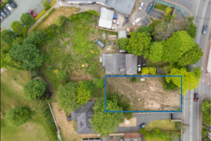
- Price
- £350,000
- Size
- 0.28 acres
Added on 27/06/2026Development Land